Birch Coppice

Wood, Forest in Warwickshire North Warwickshire

England

Birch Coppice

Essar petrol station on Watling Street, Dordon
Essar petrol station on Watling Street, Dordon Credit: David Howard

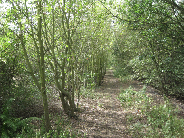
Birch Coppice is a wooded area located in Warwickshire, England. It is known for its dense population of birch trees, which give the forest its name. Covering an area of approximately 500 hectares, Birch Coppice is a significant woodland in the region.

The forest is situated near the village of Dordon and is easily accessible from the nearby towns of Tamworth and Atherstone. It offers a peaceful and serene environment, making it a popular destination for nature lovers and walkers.

The woodland is characterized by its diverse flora and fauna. Aside from the birch trees, the forest is home to a variety of other tree species, including oak, beech, and ash. This mix of trees provides a rich habitat for various animal species, such as deer, squirrels, and a wide range of bird species.

Birch Coppice is also home to a network of footpaths and trails, allowing visitors to explore the forest and enjoy its natural beauty. These paths lead to scenic spots, including a small lake, which adds to the overall charm of the woodland.

The forest is well-managed, with regular maintenance and conservation efforts in place. This ensures the preservation of its natural beauty and the sustainability of its ecosystem.

Overall, Birch Coppice is a tranquil and picturesque woodland that offers a refreshing escape from the hustle and bustle of everyday life. Its diverse flora and fauna, along with its well-maintained trails, make it an ideal destination for nature enthusiasts and those seeking a peaceful retreat in Warwickshire.

If you have any feedback on the listing, please let us know in the comments section below.

Birch Coppice Images

Images are sourced within 2km of 52.600683/-1.6097147 or Grid Reference SK2600. Thanks to Geograph Open Source API. All images are credited.

Essar petrol station on Watling Street, Dordon
Watling Street, Dordon
Starbucks, Dordon Dordon has acquired a Starbucks coffee house in this striking building at the rear of the Centurion Service Station site.
Starbucks, Dordon
Dordon has acquired a Starbucks coffee house in this striking building at the rear of the Centurion Service Station site.
Baddesley Ensor Church St Nicholas.
Baddesley Ensor Church
St Nicholas.
Ripening crops
Ripening crops
Birmingham Intermodal Freight Terminal, Birch Coppice See <a href="https://www.geograph.org.uk/photo/603341">SP2599 : Birmingham Intermodal Freight Terminal</a> This view is from the disused railway line to the south. In the background is the landscaped hill of spoil from the former Birch Coppice colliery. <span class="nowrap"><a title="http://www.roadways.co.uk/images/gallery/Birmingham-freight-terminal.jpg" rel="nofollow ugc noopener" href="http://www.roadways.co.uk/images/gallery/Birmingham-freight-terminal.jpg">Link</a><img style="margin-left:2px;" alt="External link" title="External link - shift click to open in new window" src="https://s1.geograph.org.uk/img/external.png" width="10" height="10"/></span>
Birmingham Intermodal Freight Terminal, Birch Coppice
See SP2599 : Birmingham Intermodal Freight Terminal This view is from the disused railway line to the south. In the background is the landscaped hill of spoil from the former Birch Coppice colliery. LinkExternal link
Lower House Lane by Baddesley Farm  This country is towards the northern edge of the Arden region. The land falls away unevenly to the valley of the northwest-flowing river Anker.
Lower House Lane by Baddesley Farm
This country is towards the northern edge of the Arden region. The land falls away unevenly to the valley of the northwest-flowing river Anker.
Part-harvested field behind Stone Cottage  Some chickens were having a feast. The relative height of this country only becomes apparent when a gap in the tree cover reveals the distant landscape below.
Part-harvested field behind Stone Cottage
Some chickens were having a feast. The relative height of this country only becomes apparent when a gap in the tree cover reveals the distant landscape below.
Dismantled railway south of Birch Coppice This stretch is heading for SP2599 and SP2499 on a decaying embankment. The old trackbed is not a public footpath but is perfectly walkable, though riddled with burrows and densely colonised by scrub. The line was a branch of the Midland Railway from Kingsbury to Baddesley Colliery at Baxterley (SP2798). It opened in 1878, may also have served the Birch Coppice mine, and may have been intended to replace or augment the tramway from Baddesley Colliery to the West Coast main line north of Atherstone. <span class="nowrap"><a title="http://www.irsociety.co.uk/Archives/11/william_francis.htm" rel="nofollow ugc noopener" href="http://www.irsociety.co.uk/Archives/11/william_francis.htm">Link</a><img style="margin-left:2px;" alt="External link" title="External link - shift click to open in new window" src="https://s1.geograph.org.uk/img/external.png" width="10" height="10"/></span>
Dismantled railway south of Birch Coppice
This stretch is heading for SP2599 and SP2499 on a decaying embankment. The old trackbed is not a public footpath but is perfectly walkable, though riddled with burrows and densely colonised by scrub. The line was a branch of the Midland Railway from Kingsbury to Baddesley Colliery at Baxterley (SP2798). It opened in 1878, may also have served the Birch Coppice mine, and may have been intended to replace or augment the tramway from Baddesley Colliery to the West Coast main line north of Atherstone. LinkExternal link
View northwest from Lower House Lane  Beyond the small-scale farming landscape is the vast Birmingham Intermodal Freight Terminal and associated distribution centres at Birch Coppice Business Park, the site of a former coal mine.
View northwest from Lower House Lane
Beyond the small-scale farming landscape is the vast Birmingham Intermodal Freight Terminal and associated distribution centres at Birch Coppice Business Park, the site of a former coal mine.
View north from near Baddesley Farm  Beyond the small-scale farming landscape is the vast intermodal distribution facility at Birch Coppice, a former coal mine. Prominent is a huge distribution complex under construction for Ocado, the online supermarket. Subject position is general and approximate.
View north from near Baddesley Farm
Beyond the small-scale farming landscape is the vast intermodal distribution facility at Birch Coppice, a former coal mine. Prominent is a huge distribution complex under construction for Ocado, the online supermarket. Subject position is general and approximate.
Distribution complex under construction  If I understand the Birch Coppice website correctly, this is a site of 575,000 square feet for Ocado, the "award-winning online supermarket delivering quality Waitrose groceries direct to your home." A big shed is flanked by a huge area of hardstanding. Photographed from the side of the old railway embankment, where all sign of the public footpath disappears.

Currently, Ocado handles customers' orders "at a 23-acre, 1.2m sq. ft. dedicated fulfilment centre in Hatfield, Hertfordshire. This Customer Fulfilment Centre (or 'CFC') is the largest of its kind in the world, and currently handles the same order volume as 25 supermarkets.

The four-floor CFC covers the equivalent space of eight football pitches and is operated using smart software and proprietary technology that we have designed from scratch. It houses the world's largest order storage and retrieval system. Combined, its conveyor belts extend over 10 miles. In the absence of a similar system anywhere in the world, we have made a significant investment in this innovative approach. Supporting the CFC is a network of local 'spokes' and a 75-strong fleet of single and double decker LGVs. Across the spokes, we operate a fleet of over 800 specially-designed delivery vans.

Combined, this current infrastructure enables us to reach 70% of the UK. But the big news is that we're currently working on a second super 'shed' in the West Midlands. This will be able to handle approximately 180,000 orders per week, more than doubling our current capacity. It will provide around 2,000 new jobs, from cutting-edge engineering, logistics and operations roles to picking, packing and delivery opportunities."

In the current economic climate an expansion on this scale could be seen as a huge gamble. Watch this space.
Distribution complex under construction
If I understand the Birch Coppice website correctly, this is a site of 575,000 square feet for Ocado, the "award-winning online supermarket delivering quality Waitrose groceries direct to your home." A big shed is flanked by a huge area of hardstanding. Photographed from the side of the old railway embankment, where all sign of the public footpath disappears. Currently, Ocado handles customers' orders "at a 23-acre, 1.2m sq. ft. dedicated fulfilment centre in Hatfield, Hertfordshire. This Customer Fulfilment Centre (or 'CFC') is the largest of its kind in the world, and currently handles the same order volume as 25 supermarkets. The four-floor CFC covers the equivalent space of eight football pitches and is operated using smart software and proprietary technology that we have designed from scratch. It houses the world's largest order storage and retrieval system. Combined, its conveyor belts extend over 10 miles. In the absence of a similar system anywhere in the world, we have made a significant investment in this innovative approach. Supporting the CFC is a network of local 'spokes' and a 75-strong fleet of single and double decker LGVs. Across the spokes, we operate a fleet of over 800 specially-designed delivery vans. Combined, this current infrastructure enables us to reach 70% of the UK. But the big news is that we're currently working on a second super 'shed' in the West Midlands. This will be able to handle approximately 180,000 orders per week, more than doubling our current capacity. It will provide around 2,000 new jobs, from cutting-edge engineering, logistics and operations roles to picking, packing and delivery opportunities." In the current economic climate an expansion on this scale could be seen as a huge gamble. Watch this space.
Birch Coppice intermodal freight handling facility  This is the colossal rectangular building on the map. It has an area of over 64,000 square metres (6.4 hectares). It can only be for emptying or filling the shipping containers from the terminal alongside.
In the foreground is a hardstanding under construction, part of Ocado's second Customer Fulfilment Centre. Ocado is an online supermarket that delivers Waitrose groceries to customers' homes.
Birch Coppice intermodal freight handling facility
This is the colossal rectangular building on the map. It has an area of over 64,000 square metres (6.4 hectares). It can only be for emptying or filling the shipping containers from the terminal alongside. In the foreground is a hardstanding under construction, part of Ocado's second Customer Fulfilment Centre. Ocado is an online supermarket that delivers Waitrose groceries to customers' homes.
South boundary of Birch Coppice Business Park  On the left appears about half of the south side of the 6.4 hectare shed alongside the Birmingham Intermodal Freight Terminal. In the distance is the Customer Fulfilment Centre under construction for Ocado, the online supermarket. Photographed from near the foot of the old railway embankment.
South boundary of Birch Coppice Business Park
On the left appears about half of the south side of the 6.4 hectare shed alongside the Birmingham Intermodal Freight Terminal. In the distance is the Customer Fulfilment Centre under construction for Ocado, the online supermarket. Photographed from near the foot of the old railway embankment.
Side of old railway embankment, Birch Coppice  Riddled with burrows and densely colonised by scrub, the old trackbed is perfectly walkable although not a public footpath. The line was a branch of the Midland Railway from Kingsbury to Baddesley Colliery at Baxterley. It opened in 1878, may also have served the Birch Coppice mine, and may have been intended to replace or augment the tramway from Baddesley Colliery to the West Coast main line north of Atherstone. <span class="nowrap"><a title="http://www.irsociety.co.uk/Archives/11/william_francis.htm" rel="nofollow ugc noopener" href="http://www.irsociety.co.uk/Archives/11/william_francis.htm">Link</a><img style="margin-left:2px;" alt="External link" title="External link - shift click to open in new window" src="https://s1.geograph.org.uk/img/external.png" width="10" height="10"/></span>
Side of old railway embankment, Birch Coppice
Riddled with burrows and densely colonised by scrub, the old trackbed is perfectly walkable although not a public footpath. The line was a branch of the Midland Railway from Kingsbury to Baddesley Colliery at Baxterley. It opened in 1878, may also have served the Birch Coppice mine, and may have been intended to replace or augment the tramway from Baddesley Colliery to the West Coast main line north of Atherstone. LinkExternal link
Birmingham Intermodal Freight Terminal, Birch Coppice  See <a href="https://www.geograph.org.uk/photo/603341">SP2599 : Birmingham Intermodal Freight Terminal</a> and <a href="https://www.geograph.org.uk/photo/2553243">SP2599 : Birmingham Intermodal Freight Terminal, Birch Coppice</a>. This view is from the disused railway line to the south. In the background is the landscaped hill of spoil from the former Birch Coppice colliery.
Birmingham Intermodal Freight Terminal, Birch Coppice
See SP2599 : Birmingham Intermodal Freight Terminal and SP2599 : Birmingham Intermodal Freight Terminal, Birch Coppice. This view is from the disused railway line to the south. In the background is the landscaped hill of spoil from the former Birch Coppice colliery.
Former railway bridge south of Birch Coppice  The railway crossed a track and a watercourse here. Riddled with burrows and densely colonised by scrub, the old trackbed is perfectly walkable although not a public footpath. The line was a branch of the Midland Railway from Kingsbury to Baddesley Colliery at Baxterley. It opened in 1878, may also have served the Birch Coppice mine, and may have been intended to replace or augment the tramway from Baddesley Colliery to the West Coast main line north of Atherstone. <span class="nowrap"><a title="http://www.irsociety.co.uk/Archives/11/william_francis.htm" rel="nofollow ugc noopener" href="http://www.irsociety.co.uk/Archives/11/william_francis.htm">Link</a><img style="margin-left:2px;" alt="External link" title="External link - shift click to open in new window" src="https://s1.geograph.org.uk/img/external.png" width="10" height="10"/></span>
Former railway bridge south of Birch Coppice
The railway crossed a track and a watercourse here. Riddled with burrows and densely colonised by scrub, the old trackbed is perfectly walkable although not a public footpath. The line was a branch of the Midland Railway from Kingsbury to Baddesley Colliery at Baxterley. It opened in 1878, may also have served the Birch Coppice mine, and may have been intended to replace or augment the tramway from Baddesley Colliery to the West Coast main line north of Atherstone. LinkExternal link
Tamworth container terminal Taken when I was delivering to the unit next door shortly after buying my new camera! This is the container terminal just off the A5/M42 junction near Tamworth in Staffordshire, taken around 6pm.
Tamworth container terminal
Taken when I was delivering to the unit next door shortly after buying my new camera! This is the container terminal just off the A5/M42 junction near Tamworth in Staffordshire, taken around 6pm.
Show me another place!

Birch Coppice is located at Grid Ref: SK2600 (Lat: 52.600683, Lng: -1.6097147)

Administrative County: Warwickshire

District: North Warwickshire

Police Authority: Warwickshire

What 3 Words

///daredevil.inspector.priced. Near Polesworth, Warwickshire

Related Wikis

Dordon

Dordon is a village and civil parish in the North Warwickshire district of the county of Warwickshire in England and close to the border with Staffordshire...

Mercia

Mercia (, Old English: Miercna rīċe; Latin: Merciorum regnum) was one of the three main Anglic kingdoms founded after Sub-Roman Britain was settled by...

The Polesworth School

The Polesworth School is a coeducational secondary school located in Dordon, near Polesworth, Warwickshire, England. The Headteacher is Maura Favell....

Polesworth

Polesworth is a large village and civil parish in the North Warwickshire district of Warwickshire, England. It is situated close to the northern tip of...

Birchmoor

Birchmoor is a former coal mining village in the North Warwickshire district of Warwickshire, England. It lies about one mile southwest of Polesworth...

Polesworth Vicarage

Polesworth Vicarage stands adjacent to St Editha's Church in High Street, Polesworth, Warwickshire, England. It is recorded in the National Heritage List...

Polesworth Abbey

Polesworth Abbey was a Benedictine nunnery in Polesworth, North Warwickshire, England. == Abbey == It was founded in the 9th century by St. Modwena and...

Tamworth services

Tamworth services is a motorway service station on the M42 motorway near Tamworth Staffordshire, England. The border between Staffordshire and Warwickshire...

Nearby Amenities

Located within 500m of 52.600683,-1.6097147
Bus Stop
Church;Long Street
Bus: yes
Layby: yes
Naptan AtcoCode: 4200F019100;4200F170301
Naptan Bearing: SE
Naptan CommonName: Church;Long Street
Naptan Indicator: Adj
Naptan Landmark: Coppice Corner
Naptan NaptanCode: warajtpt;warampmg
Naptan Street: Watling Street
Public Transport: platform
Source: naptan_import
Lat/Long: 52.5981121/-1.6155412
Bus Stop
Texaco Garage
Bus: yes
Naptan AtcoCode: 4200F170401
Naptan Bearing: SE
Naptan CommonName: Texaco Garage
Naptan Indicator: Adj
Naptan NaptanCode: warampmt
Naptan Street: Watling Street
Naptan Verified: no
Public Transport: platform
Source: naptan_import
Lat/Long: 52.5963917/-1.6100831
Bus Stop
Texaco Garage
Bus: yes
Naptan AtcoCode: 4200F170402
Naptan Bearing: NW
Naptan CommonName: Texaco Garage
Naptan Indicator: Opp
Naptan NaptanCode: warampmw
Naptan Street: A5
Naptan Verified: no
Public Transport: platform
Source: naptan_import
Lat/Long: 52.5964024/-1.610656
Bus Stop
Church
Bus: yes
Naptan AtcoCode: 4200F175601
Naptan Bearing: N
Naptan CommonName: Church
Naptan Indicator: Adj
Naptan Landmark: Church
Naptan NaptanCode: warapjpg
Naptan Street: Long Street
Naptan Verified: no
Public Transport: platform
Source: naptan_import
Lat/Long: 52.5984477/-1.6149651
Bus Stop
Browns Lane
Bus: yes
Naptan AtcoCode: 4200F180001
Naptan Bearing: N
Naptan CommonName: Browns Lane
Naptan Indicator: Nr
Naptan NaptanCode: warawagm
Naptan Street: New Street
Naptan Verified: no
Public Transport: platform
Source: naptan_import
Lat/Long: 52.599943/-1.6166353
Fast Food
Dordon Fish Bar
Lat/Long: 52.600942/-1.6154424
Fast Food
Pearl City
Cuisine: chinese
Lat/Long: 52.6007042/-1.6162895
Spar
Brand: Spar
Brand Wikidata: Q610492
Brand Wikipedia: en:SPAR (retailer)
Shop: convenience
Website: https://www.spar.co.uk/store-locator/afb13635-spar-whitmore-dordon/
Lat/Long: 52.6009095/-1.6156087
Post Box
Ref: B78 397
Lat/Long: 52.6016196/-1.6145943
Dordon
Place: village
Wikidata: Q5297639
Lat/Long: 52.5995055/-1.615482
Give Way
Lat/Long: 52.5983161/-1.6148314
Source: Bing
Traffic Calming: cushion
Lat/Long: 52.6024285/-1.6144162
Source: Bing
Traffic Calming: cushion
Lat/Long: 52.6041324/-1.6144238
Generator Method: photovoltaic
Generator Output Electricity: yes
Generator Source: solar
Generator Type: solar_photovoltaic_panel
Location: roof
Power: generator
Lat/Long: 52.6011953/-1.6156742
Generator Method: photovoltaic
Generator Output Electricity: yes
Generator Source: solar
Generator Type: solar_photovoltaic_panel
Location: roof
Power: generator
Lat/Long: 52.6010503/-1.6125682
Generator Method: photovoltaic
Generator Output Electricity: yes
Generator Source: solar
Generator Type: solar_photovoltaic_panel
Location: roof
Power: generator
Lat/Long: 52.6011188/-1.6136196
Generator Method: photovoltaic
Generator Output Electricity: yes
Generator Source: solar
Generator Type: solar_photovoltaic_panel
Location: roof
Power: generator
Lat/Long: 52.6021565/-1.616554
Generator Method: photovoltaic
Generator Output Electricity: yes
Generator Source: solar
Generator Type: solar_photovoltaic_panel
Location: roof
Power: generator
Lat/Long: 52.6004525/-1.6170234
Generator Method: photovoltaic
Generator Output Electricity: yes
Generator Source: solar
Generator Type: solar_photovoltaic_panel
Location: roof
Power: generator
Lat/Long: 52.6021972/-1.6069315
Drinking Water: yes
Man Made: water_tap
Lat/Long: 52.596683/-1.6089486
The data included in this document is from www.openstreetmap.org. The data is made available under ODbL.

Have you been to Birch Coppice?

Leave your review of Birch Coppice below (or comments, questions and feedback).