Bandland Coppice

Wood, Forest in Staffordshire Lichfield

England

Bandland Coppice

Clifton Campville from the air Clifton Campville is towards the lower left corner. Junction 11 on the M42/A42 is to the right of centre.
Clifton Campville from the air Credit: Thomas Nugent

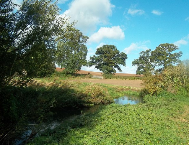
Bandland Coppice is a picturesque woodland located in Staffordshire, England. Situated in close proximity to the village of Hoar Cross, it covers an area of approximately 50 acres and is known for its diverse range of flora and fauna.

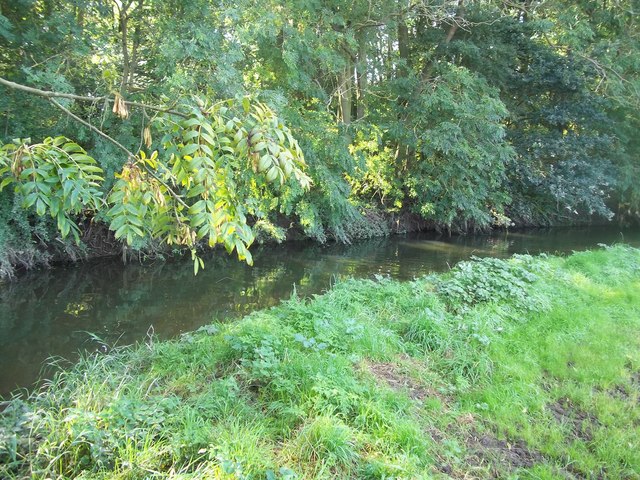
As one enters Bandland Coppice, they are greeted by a dense canopy of ancient oak, birch, and beech trees that create a tranquil and serene atmosphere. The woodland floor is adorned with an array of wildflowers, including bluebells, primroses, and wood anemones, adding bursts of color to the landscape during springtime.

Walking along the well-maintained trails, visitors can spot various wildlife species that call Bandland Coppice their home. Squirrels scurry through the branches above, while rabbits and foxes can occasionally be seen darting across the forest floor. Bird enthusiasts will be delighted by the presence of woodpeckers, owls, and numerous songbirds filling the air with their melodious tunes.

Bandland Coppice is not only a haven for nature enthusiasts but also a popular destination for outdoor activities. The woodland offers several designated picnic areas, making it an ideal spot for families and groups to enjoy a day out in nature. Additionally, there are ample opportunities for hiking and cycling, with several well-marked trails winding their way through the forest.

Overall, Bandland Coppice is a hidden gem in Staffordshire, offering a peaceful retreat from the hustle and bustle of everyday life. Its natural beauty and diverse ecosystem make it a must-visit destination for those seeking solace in nature's embrace.

If you have any feedback on the listing, please let us know in the comments section below.

Bandland Coppice Images

Images are sourced within 2km of 52.689767/-1.6110815 or Grid Reference SK2610. Thanks to Geograph Open Source API. All images are credited.

Clifton Campville from the air Clifton Campville is towards the lower left corner. Junction 11 on the M42/A42 is to the right of centre.
Clifton Campville from the air
Clifton Campville is towards the lower left corner. Junction 11 on the M42/A42 is to the right of centre.
The Road to Clifton Campville from Lullington
Entering Clifton Campville from Haunton
Smith Lane / Clifton Lane Road Junction, Clifton Campville
House for Sale on the Outskirts of Clifton Campville
The River Mease near Stones Bridge River and county boundary just outside Clifton Campville. The far bank is in Staffordshire and the picture was taken in Derbyshire.
The River Mease near Stones Bridge
River and county boundary just outside Clifton Campville. The far bank is in Staffordshire and the picture was taken in Derbyshire.
The Most Southerly Point in Derbyshire This stretch of riverbank is the very southern tip of the county. It's at SK26731105 close to Clifton Campville, separated from Staffordshire by the River Mease.
The Most Southerly Point in Derbyshire
This stretch of riverbank is the very southern tip of the county. It's at SK26731105 close to Clifton Campville, separated from Staffordshire by the River Mease.
The River Mease near Seal Fields Farm 3 counties share this grid square. This picture was taken from Derbyshire with Leicestershire on the opposite bank. Further along the far bank we are over into Staffordshire.
The River Mease near Seal Fields Farm
3 counties share this grid square. This picture was taken from Derbyshire with Leicestershire on the opposite bank. Further along the far bank we are over into Staffordshire.
Rectory Cottage, Clifton Campville
St Andrew's Church, Clifton Campville
Church Street, Clifton Campville
River Mease near Clifton Campville
Minor road towards Lullington Heading north.
Minor road towards Lullington
Heading north.
Farmland near Mill Farm Bald Hill's Farm in the distance.
Farmland near Mill Farm
Bald Hill's Farm in the distance.
St Andrew's Church, Clifton Campville - monument to Sir John Vernon An outstanding alabaster monument to Sir John Vernon (†1545) and his wife on a tomb-chest. Sir John was a lawyer in Tudor times during the reign of Henry VIII.

<a href="https://www.geograph.org.uk/photo/4461900">SK2510 : St Andrew's Church, Clifton Campville - monument to Sir John Vernon - detail (1)</a>
St Andrew's Church, Clifton Campville - monument to Sir John Vernon
An outstanding alabaster monument to Sir John Vernon (†1545) and his wife on a tomb-chest. Sir John was a lawyer in Tudor times during the reign of Henry VIII. SK2510 : St Andrew's Church, Clifton Campville - monument to Sir John Vernon - detail (1)
St Andrew's Church, Clifton Campville - monument to Sir John Vernon - detail (1) Sir John Vernon (†1545) and his wife.

<a href="https://www.geograph.org.uk/photo/4461901">SK2510 : St Andrew's Church, Clifton Campville - monument to Sir John Vernon - detail (2)</a>
St Andrew's Church, Clifton Campville - monument to Sir John Vernon - detail (1)
St Andrew's Church, Clifton Campville - monument to Sir John Vernon - detail (2) Sir John Vernon (†1545) and his wife.
St Andrew's Church, Clifton Campville - monument to Sir John Vernon - detail (2)
Sir John Vernon (†1545) and his wife.
Lullington Road towards Clifton Campville
Show me another place!

Bandland Coppice is located at Grid Ref: SK2610 (Lat: 52.689767, Lng: -1.6110815)

Administrative County: Staffordshire

District: Lichfield

Police Authority: Staffordshire

What 3 Words

///inversion.trader.blesses. Near Donisthorpe, Leicestershire

Related Wikis

Clifton Campville

Clifton Campville is a village, former manor and civil parish in Staffordshire, England. It lies on the River Mease, about 10 miles (16 km) east of the...

Church of St Andrew, Clifton Campville

The Church of St Andrew is a Grade I listed church in the village of Clifton Campville, Staffordshire. It was built in the 13th and 14th centuries. The...

Thorpe Constantine

Thorpe Constantine is a small village and civil parish in Staffordshire, England. It lies about 6 miles (10 km) north-east of Tamworth and 6 miles south...

River Mease SSSI

River Mease SSSI is a 23.0 hectares (57 acres) biological Site of Special Scientific Interest. It is a stretch of the River Mease and its tributary Gilwiskaw...

Chilcote

Chilcote is a village and civil parish in the North West Leicestershire district of Leicestershire, England. Until 1897 it was in Derbyshire. The parish...

Haunton

Haunton is a village in Staffordshire, England. It lies on the River Mease, about 7 miles (11 km) north of Tamworth, 1½ miles east of Harlaston and 1 mile...

Seckington

Seckington is a village and civil parish in North Warwickshire, about 4 miles (6 km) northeast of Tamworth. The B4593 road between Tamworth and Appleby...

No Man's Heath, Warwickshire

No Man's Heath is an area of the civil parish of Newton Regis, in the North Warwickshire district, in the county of Warwickshire, England, about 6 miles...

Nearby Amenities

Located within 500m of 52.689767,-1.6110815
Power: pole
Lat/Long: 52.6858951/-1.6085824
Power: pole
Lat/Long: 52.6866233/-1.6071578
Power: pole
Lat/Long: 52.6872732/-1.6061105
Power: pole
Lat/Long: 52.6879306/-1.6050259
Power: pole
Lat/Long: 52.6886241/-1.6039041
The data included in this document is from www.openstreetmap.org. The data is made available under ODbL.

Have you been to Bandland Coppice?

Leave your review of Bandland Coppice below (or comments, questions and feedback).