Bean's Covert

Wood, Forest in Staffordshire East Staffordshire

England

Bean's Covert

Branston Water Park This image was taken of Branston Water Park.  The area was an old quarry site that has been transformed into a tourist site.  It is a popular site for model boat enthusiasts.  The fenced off area in the foreground is there to let the grass regrow due to excessive eating by the local wildlife
Branston Water Park Credit: Jason Wood

Bean's Covert is a picturesque woodland located in the county of Staffordshire, England. Situated near the village of Stafford, this enchanting forest covers an area of approximately 100 acres. It is a popular destination for nature lovers, hikers, and wildlife enthusiasts.

The woodland is characterized by its dense and diverse collection of trees, including oak, beech, birch, and pine. These towering trees create a mesmerizing canopy, providing a stunning display of colors throughout the changing seasons. The forest floor is adorned with a carpet of wildflowers, ferns, and moss, adding to the natural beauty of the area.

Bean's Covert offers a variety of walking trails, ranging from easy strolls to more challenging hikes. These trails wind through the woods, leading visitors on a journey of discovery. Along the way, one can encounter a plethora of wildlife, including deer, foxes, squirrels, and a wide array of bird species. It is also home to several protected species, such as the great crested newt and the lesser spotted woodpecker.

The forest is managed by the local authorities to preserve its natural beauty and biodiversity. Several conservation projects have been implemented to protect the woodland and its inhabitants. There are information boards placed throughout the area, providing educational content about the flora and fauna found in the covert.

Bean's Covert offers a peaceful and serene escape from the hustle and bustle of daily life. Its tranquil ambiance and breathtaking scenery make it a perfect destination for nature enthusiasts seeking to immerse themselves in the beauty of the Staffordshire countryside.

If you have any feedback on the listing, please let us know in the comments section below.

Bean's Covert Images

Images are sourced within 2km of 52.793697/-1.6611409 or Grid Reference SK2221. Thanks to Geograph Open Source API. All images are credited.

Branston Water Park This image was taken of Branston Water Park.  The area was an old quarry site that has been transformed into a tourist site.  It is a popular site for model boat enthusiasts.  The fenced off area in the foreground is there to let the grass regrow due to excessive eating by the local wildlife
Branston Water Park
This image was taken of Branston Water Park. The area was an old quarry site that has been transformed into a tourist site. It is a popular site for model boat enthusiasts. The fenced off area in the foreground is there to let the grass regrow due to excessive eating by the local wildlife
Waterfowl on Branston Water Park Branston Water Park is situated between the Trent and Mersey Canal and the A38 road just SW of Burton. The area was first quarried for aggregates during the 1930's. The quarry was then functional up until the 1950's when it started to become too costly to continue pumping out the water, since then the quarry has gradually filled up with a natural supply of water as the water table has gradually risen up to today's present level. In 1989 the council started to make the site into an area suitable for the public to use for recreation. The Water Park has a number of different public users apart from tourists and bird watchers (the park has a naturally growing set of reed beds which are quite rare to Staffordshire). The clubs at present that use the water are the model boat club, fishermen and wind surfers
Waterfowl on Branston Water Park
Branston Water Park is situated between the Trent and Mersey Canal and the A38 road just SW of Burton. The area was first quarried for aggregates during the 1930's. The quarry was then functional up until the 1950's when it started to become too costly to continue pumping out the water, since then the quarry has gradually filled up with a natural supply of water as the water table has gradually risen up to today's present level. In 1989 the council started to make the site into an area suitable for the public to use for recreation. The Water Park has a number of different public users apart from tourists and bird watchers (the park has a naturally growing set of reed beds which are quite rare to Staffordshire). The clubs at present that use the water are the model boat club, fishermen and wind surfers
Branston Water Park North end of Branston Water Park looking beyond the visitor centre to Drakelow Power Station in the background
Branston Water Park
North end of Branston Water Park looking beyond the visitor centre to Drakelow Power Station in the background
Church near the Town Hall This splendid church is near the civic centre along with the Victorian town hall.
Church near the Town Hall
This splendid church is near the civic centre along with the Victorian town hall.
River Trent floodplain south of Branston, Staffordshire The River Trent flows north-eastwards by the line of trees in the top right of the picture. The flood plain on either side of the railway line is former gravel pits that were filled in with flyash from nearby Drakelow Power Station during the 1960s and early 70s. The land is now partly used for rough grazing (sheep). The village of Branston (original home of the famous pickle) is clearly visible in the distance, on and beyond the northern edge of the grid square. Some taller buildings (namely the tower of Coors maltings) of the brewery town of Burton upon Trent are just visible beyond Branston. An early evening Virgin Voyager express train hurries from Birmingham, towards Burton upon Trent and Derby. The photograph was taken looking north-eastwards, at 19.27 hours, from the top of a recently erected footbridge over the railway and which as yet does not appear on any OS maps.
River Trent floodplain south of Branston, Staffordshire
The River Trent flows north-eastwards by the line of trees in the top right of the picture. The flood plain on either side of the railway line is former gravel pits that were filled in with flyash from nearby Drakelow Power Station during the 1960s and early 70s. The land is now partly used for rough grazing (sheep). The village of Branston (original home of the famous pickle) is clearly visible in the distance, on and beyond the northern edge of the grid square. Some taller buildings (namely the tower of Coors maltings) of the brewery town of Burton upon Trent are just visible beyond Branston. An early evening Virgin Voyager express train hurries from Birmingham, towards Burton upon Trent and Derby. The photograph was taken looking north-eastwards, at 19.27 hours, from the top of a recently erected footbridge over the railway and which as yet does not appear on any OS maps.
Coors Brewers Maltings, Burton upon Trent Coors Brewers Maltings Division Shobnall Site, is located on Wellington Road. The maltings were originally built by the world famous Bass Brewery, which was taken over by the American brewery Coors, around the late 1990s. The barley that is malted to produce lagers and beers, arrives in articulated lorries (most seem to be from East Anglia) which enter the site by the raised barrier. The barley is stored in corrugated steel silos - some of which can be seen to the right - and is then malted in the large concrete tower, before being taken across town to the brewery.
Coors Brewers Maltings, Burton upon Trent
Coors Brewers Maltings Division Shobnall Site, is located on Wellington Road. The maltings were originally built by the world famous Bass Brewery, which was taken over by the American brewery Coors, around the late 1990s. The barley that is malted to produce lagers and beers, arrives in articulated lorries (most seem to be from East Anglia) which enter the site by the raised barrier. The barley is stored in corrugated steel silos - some of which can be seen to the right - and is then malted in the large concrete tower, before being taken across town to the brewery.
Parkway, Centrum 100, Branston, Burton upon Trent, Staffordshire. Centrum 100 is a modern business park built alongside the A38(T) and its access interchange. It is a mixture of distribution warehouses, manufacturing, offices and retailing. The large white building is called First Point and is the latest development. It was completed in June 2006, for sale or rental. Other units visible include the former Littlewoods Stores distribution warehouse, operated by Wincanton Logistics on the right, with Coors Brewers distribution warehouse on the left. Parkway extension, which leads straight on, was opened in September 1998.
Parkway, Centrum 100, Branston, Burton upon Trent, Staffordshire.
Centrum 100 is a modern business park built alongside the A38(T) and its access interchange. It is a mixture of distribution warehouses, manufacturing, offices and retailing. The large white building is called First Point and is the latest development. It was completed in June 2006, for sale or rental. Other units visible include the former Littlewoods Stores distribution warehouse, operated by Wincanton Logistics on the right, with Coors Brewers distribution warehouse on the left. Parkway extension, which leads straight on, was opened in September 1998.
Farmland to the south of Forest Road, Shobnall, Burton upon Trent, Staffordshire. Looking north-east across farmland (grass recently mown for hay) towards the rear of The Albion Hotel on Forest Road - the large brick building in the centre of the image. Flat-topped underground reservoirs and a telecommunications mast can be clearly seen on the skyline, just to the north of Oaks Wood. A new industrial unit, part of the Centrum 100 West development, can be seen to the east of the A38(T). It is owned by Kongsberg who manufacture parts for the automotive industry. Shobnall Grange is hidden by the large hedgerow on the left of the image.
Farmland to the south of Forest Road, Shobnall, Burton upon Trent, Staffordshire.
Looking north-east across farmland (grass recently mown for hay) towards the rear of The Albion Hotel on Forest Road - the large brick building in the centre of the image. Flat-topped underground reservoirs and a telecommunications mast can be clearly seen on the skyline, just to the north of Oaks Wood. A new industrial unit, part of the Centrum 100 West development, can be seen to the east of the A38(T). It is owned by Kongsberg who manufacture parts for the automotive industry. Shobnall Grange is hidden by the large hedgerow on the left of the image.
Looking south across farmland from Shobnall to Branston, Burton upon Trent, Staffordshire. Image was taken on a river terrace below the Sinai Park escarpment, looking south from Shobnall, across the floodplain of the River Trent, towards Branston. The land to the east of the A38(T) is earmarked for development as part of the Centrum 100 West Business Park. The fields to the west of the A38(T), that have just been mown for hay, have recently been removed from local plans for future industrial development. The tarmac track that runs parallel with the A38(T), is part of the Sustrans National Cycle Network - Route 54.
Looking south across farmland from Shobnall to Branston, Burton upon Trent, Staffordshire.
Image was taken on a river terrace below the Sinai Park escarpment, looking south from Shobnall, across the floodplain of the River Trent, towards Branston. The land to the east of the A38(T) is earmarked for development as part of the Centrum 100 West Business Park. The fields to the west of the A38(T), that have just been mown for hay, have recently been removed from local plans for future industrial development. The tarmac track that runs parallel with the A38(T), is part of the Sustrans National Cycle Network - Route 54.
Main Street, Branston, Burton upon Trent, Staffordshire. This row of shops is situated in the centre of the village, just off the main road - the B5108 that runs just behind the pub. The shops comprise of a hairdressing salon, fish and chip shop, newsagents and a pets and gardens store. A butcher is located behind the shops and flats have been built above them. A small local recycling facility can be found in the corner of the pub car park, adjacent to the shops.
Main Street, Branston, Burton upon Trent, Staffordshire.
This row of shops is situated in the centre of the village, just off the main road - the B5108 that runs just behind the pub. The shops comprise of a hairdressing salon, fish and chip shop, newsagents and a pets and gardens store. A butcher is located behind the shops and flats have been built above them. A small local recycling facility can be found in the corner of the pub car park, adjacent to the shops.
Lawns Farm, Branston, Burton upon Trent, Staffordshire. In addition to the obvious farmland and Lawns Farm itself, the following features can just be picked out on the skyline from left to right:
recent barn conversions at Sinai Park; Marston's Brewery at Shobnall; cooling towers at the now derelict Willington Power Station; industrial units on Centrum 100 Business Park; and Coors Brewers maltings tower.
Lawns Farm, Branston, Burton upon Trent, Staffordshire.
In addition to the obvious farmland and Lawns Farm itself, the following features can just be picked out on the skyline from left to right: recent barn conversions at Sinai Park; Marston's Brewery at Shobnall; cooling towers at the now derelict Willington Power Station; industrial units on Centrum 100 Business Park; and Coors Brewers maltings tower.
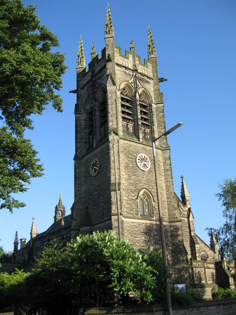
All Saints Church, Branstone Road, Burton upon Trent, Staffordshire Early evening sunshine adds warmth and colour to the normally dull looking stonework of the imposing clocktower. Note the spelling of Branstone Road - the modern spelling of the village name is Branston (the original home of the world famous pickle).
All Saints Church, Branstone Road, Burton upon Trent, Staffordshire
Early evening sunshine adds warmth and colour to the normally dull looking stonework of the imposing clocktower. Note the spelling of Branstone Road - the modern spelling of the village name is Branston (the original home of the world famous pickle).
Flood defences at Branston, Burton upon Trent, Staffordshire. The embankment provides flood protection to properties along or near to Burton Road, Branston. To the left is Paget High School's playing fields and the 'Golfers Estate' (all roads are named after famous golfers or golf courses). To the right is the edge of Branston Golf and Country Club's golf course, whilst the River Trent is less than 50 metres to the right of the photographer.
Flood defences at Branston, Burton upon Trent, Staffordshire.
The embankment provides flood protection to properties along or near to Burton Road, Branston. To the left is Paget High School's playing fields and the 'Golfers Estate' (all roads are named after famous golfers or golf courses). To the right is the edge of Branston Golf and Country Club's golf course, whilst the River Trent is less than 50 metres to the right of the photographer.
Branston Depot - the original home of Branston Pickle Branston Depot is situated on Burton Road, Branston, Burton upon Trent, Staffordshire. It was built in 1915 as the National Machine Gun Factory and was then taken over by Crosse and Blackwell in the 1920s, with the village giving its name to the world famous pickle that was first produced there. In the 1930s it became a silk factory and was taken over by the Army in the Second World War as their Central Ordnance Depot. They remained there until the 1960s, when it then became Home Office stores, supplying prisons and storing the former AFS 'Green Goddess' fire engines. The 'Green Goddesses', which were used by the military during national firefighters' strikes, moved to a store at nearby Marchington at the end of the 1980s. In 2004, part of the Depot was leased to B&Q and is operated as a distribution depot for them by the logistics firm TNT. A massive fire at the beginning of 2006, destroyed millions of pounds worth of fitted kitchens stock and the warehouse centred on SK23552162.
Branston Depot - the original home of Branston Pickle
Branston Depot is situated on Burton Road, Branston, Burton upon Trent, Staffordshire. It was built in 1915 as the National Machine Gun Factory and was then taken over by Crosse and Blackwell in the 1920s, with the village giving its name to the world famous pickle that was first produced there. In the 1930s it became a silk factory and was taken over by the Army in the Second World War as their Central Ordnance Depot. They remained there until the 1960s, when it then became Home Office stores, supplying prisons and storing the former AFS 'Green Goddess' fire engines. The 'Green Goddesses', which were used by the military during national firefighters' strikes, moved to a store at nearby Marchington at the end of the 1980s. In 2004, part of the Depot was leased to B&Q and is operated as a distribution depot for them by the logistics firm TNT. A massive fire at the beginning of 2006, destroyed millions of pounds worth of fitted kitchens stock and the warehouse centred on SK23552162.
Trent Mersey Canal near Branston Water Park The Way for the Millennium on the Trent Mersey Canal near Branston Water Park.
Trent Mersey Canal near Branston Water Park
The Way for the Millennium on the Trent Mersey Canal near Branston Water Park.
Burton upon Trent Fire Station Wholetime station in the Eastern corner of Staffordshire
Burton upon Trent Fire Station
Wholetime station in the Eastern corner of Staffordshire
Winter at Branston View from the railway foot crossing at Branston, with Drakelowe Power station (now demolished), in the background
Winter at Branston
View from the railway foot crossing at Branston, with Drakelowe Power station (now demolished), in the background
View across the rails View across Birmingham South Curve Junction at Branston, with the now demolished Drakelow power station in the background. All the land on the far side of the rails has now been subjected to housing development.
View across the rails
View across Birmingham South Curve Junction at Branston, with the now demolished Drakelow power station in the background. All the land on the far side of the rails has now been subjected to housing development.
Show me another place!

Bean's Covert is located at Grid Ref: SK2221 (Lat: 52.793697, Lng: -1.6611409)

Administrative County: Staffordshire

District: East Staffordshire

Police Authority: Staffordshire

What 3 Words

///reduce.tamed.modest. Near Burton upon Trent, Staffordshire

Related Wikis

Nearby Amenities

Located within 500m of 52.793697,-1.6611409
Traffic Calming: cushion
Lat/Long: 52.7931199/-1.6569955
Traffic Calming: cushion
Lat/Long: 52.7904498/-1.6586677
Traffic Calming: cushion
Lat/Long: 52.7897739/-1.658646
Give Way
Lat/Long: 52.7947051/-1.6656697
Turning Circle
Lat/Long: 52.7926125/-1.666481
Atm
Operator: HSBC
Lat/Long: 52.7948666/-1.6627857
Atm
Operator: Lloyds Bank
Lat/Long: 52.7948921/-1.6627379
Pharmacy
Morrisons Pharmacy
Addr City: Burton-on-Trent
Addr Housename: Morrisons Pharmacy
Addr Housenumber: 113-129
Addr Postcode: DE14 2AR
Addr Street: Clays Lane
Healthcare: pharmacy
Operator: Morrisons
Lat/Long: 52.7943123/-1.663173
Atm
Operator: Barclays Bank PLC
Lat/Long: 52.7948428/-1.6628325
Crossing
Crossing: marked
Lat/Long: 52.7949548/-1.6674406
Mini Roundabout
Direction: clockwise
Lat/Long: 52.7949389/-1.6648197
Crossing
Crossing: unmarked
Crossing Markings: no
Lat/Long: 52.7955693/-1.6674687
Turning Circle
Lat/Long: 52.7939014/-1.6659402
Post Box
Operator: Royal Mail
Ref: DE14 1229
Lat/Long: 52.7936875/-1.65891
Post Box
Operator: Royal Mail
Ref: DE14 1198
Lat/Long: 52.7945818/-1.6631108
Post Box
Operator: Royal Mail
Ref: DE14 1001
Lat/Long: 52.792542/-1.6643587
Crossing
Lat/Long: 52.7955418/-1.6608486
Crossing
Crossing: unmarked
Crossing Markings: no
Lat/Long: 52.7954743/-1.6662177
Crossing
Crossing: unmarked
Crossing Markings: no
Lat/Long: 52.7953707/-1.6661973
Crossing
Crossing: unmarked
Crossing Markings: no
Lat/Long: 52.7956244/-1.6674312
Crossing
Crossing: unmarked
Crossing Markings: no
Lat/Long: 52.7957871/-1.6666506
Crossing
Crossing: unmarked
Crossing Markings: no
Lat/Long: 52.7958211/-1.6668187
Crossing
Crossing: zebra
Lat/Long: 52.7941704/-1.6636514
Access: customers
Entrance: main
Lat/Long: 52.7942172/-1.6635001
Crossing
Crossing: marked
Crossing Island: no
Tactile Paving: no
Traffic Calming: table
Lat/Long: 52.794631/-1.667193
Traffic Signals
Lat/Long: 52.795569/-1.6609043
Recycling
Lat/Long: 52.7951825/-1.664745
Turning Circle
Lat/Long: 52.7898676/-1.6645869
Man Made: pumping_station
Source: survey
Substance: sewage
Lat/Long: 52.7926469/-1.6631109
Railway: switch
Lat/Long: 52.7904564/-1.6616435
Railway: switch
Lat/Long: 52.7902943/-1.6619063
Branston Junction
Railway: junction
Lat/Long: 52.790525/-1.6615798
Railway: signal
Railway Signal: main
Railway Signal Catenary Mast: yes
Lat/Long: 52.7914019/-1.6605183
School
The Strumalong Guitar School
Addr Housenumber: 8
Wheelchair: no
Lat/Long: 52.792875/-1.665491
Car Wash
Lat/Long: 52.7959985/-1.66721
Traffic Signals
Lat/Long: 52.7953568/-1.6610276
Traffic Signals
Lat/Long: 52.7952757/-1.6604473
Traffic Signals
Lat/Long: 52.7955233/-1.6603645
Entrance: yes
Lat/Long: 52.7961417/-1.665821
Access: private
Barrier: lift_gate
Lat/Long: 52.7971241/-1.6648794
Access: customers
Entrance: yes
Lat/Long: 52.7945459/-1.6633987
Charging Station
Capacity: 3
Fee: yes
Operator: Instavolt
Lat/Long: 52.7933029/-1.6685075
Smoking Area
Bench: yes
Bin: yes
Shelter: yes
Lat/Long: 52.7970561/-1.6653696
Entrance: yes
Lat/Long: 52.7957591/-1.6658747
Leisure: picnic_table
Lat/Long: 52.7958835/-1.6662332
Barrier: height_restrictor
Maxheight: 2.1
Lat/Long: 52.7975579/-1.6643877
Direction: both
Traffic Calming: bump
Lat/Long: 52.7974565/-1.6645168
Access: permit
Barrier: lift_gate
Foot: no
Lat/Long: 52.797004/-1.6647818
Access: permit
Barrier: lift_gate
Foot: no
Lat/Long: 52.7970558/-1.6649117
Bus Stop
Sedgefield Road
Naptan AtcoCode: 3800C301801
Public Transport: platform
Lat/Long: 52.7909354/-1.6589999
Bus Stop
Heather Close
Naptan AtcoCode: 3800C320801
Naptan NaptanCode: stadgapg
Public Transport: platform
Lat/Long: 52.7921762/-1.6585144
Bus Stop
Pershore Drive
Naptan AtcoCode: 3800C320601
Naptan NaptanCode: stadgamt
Public Transport: platform
Lat/Long: 52.7932207/-1.6562493
Bus Stop
Caraway Drive
Naptan AtcoCode: 3800C320302
Naptan NaptanCode: stadgamg
Public Transport: platform
Lat/Long: 52.7943488/-1.6539373
Bus Stop
Morrisons Supermarket
Public Transport: platform
Lat/Long: 52.7940455/-1.6651127
Bus Stop
Morrisons Supermarket
Public Transport: platform
Lat/Long: 52.7938606/-1.6649866
Bus Stop
Cotswold Road
Naptan AtcoCode: 3800C316901
Naptan NaptanCode: stadawjd
Public Transport: platform
Lat/Long: 52.7915307/-1.6641216
Bus Stop
Cotswold Road
Naptan AtcoCode: 3800C316902
Naptan NaptanCode: stadawjg
Public Transport: platform
Lat/Long: 52.7912485/-1.664532
Railway: switch
Lat/Long: 52.7898825/-1.6625286
Traffic Calming: cushion
Lat/Long: 52.793777/-1.6555238
Traffic Calming: cushion
Lat/Long: 52.7943673/-1.6546282
Crossing
Crossing: marked
Lat/Long: 52.7940767/-1.6682
Traffic Calming: cushion
Lat/Long: 52.792551/-1.658192
Traffic Calming: cushion
Lat/Long: 52.7914413/-1.6593039
Crossing
Crossing: marked
Lat/Long: 52.7947467/-1.6671231
Entrance: yes
Lat/Long: 52.7947875/-1.6671301
Bus Stop
Bus: yes
Naptan AtcoCode: 3800C347901
Naptan NaptanCode: stadjawt
Public Transport: platform
Lat/Long: 52.7965239/-1.6663035
Turning Circle
Lat/Long: 52.793653/-1.6670291
Crossing
Crossing Island: yes
Lat/Long: 52.794741/-1.6655392
Crossing
Crossing: unmarked
Crossing Markings: no
Lat/Long: 52.7950753/-1.6666241
Crossing
Crossing: unmarked
Crossing Markings: no
Lat/Long: 52.795051/-1.6667844
Crossing
Crossing: unmarked
Crossing Markings: no
Lat/Long: 52.7952298/-1.6674702
Crossing
Crossing: unmarked
Crossing Markings: no
Lat/Long: 52.7951427/-1.6673926
The data included in this document is from www.openstreetmap.org. The data is made available under ODbL.

Have you been to Bean's Covert?

Leave your review of Bean's Covert below (or comments, questions and feedback).