Eastern Plantation

Wood, Forest in Wiltshire

England

Eastern Plantation

Outdoor Seating Area, Cholderton Farm Shop and Cafe
Outdoor Seating Area, Cholderton Farm Shop and Cafe Credit: Paul Collins

Eastern Plantation is a charming woodland located in the county of Wiltshire, England. Situated in the eastern part of the county, it covers a vast area and is renowned for its stunning natural beauty. The plantation is primarily composed of dense woodlands and a variety of forested areas, making it a haven for nature enthusiasts and outdoor adventurers.

The plantation boasts a diverse range of tree species, including oak, beech, ash, and pine, creating a rich and vibrant ecosystem. These trees provide a haven for numerous wildlife species, such as deer, foxes, badgers, and a plethora of bird species, making it a popular spot for birdwatchers and wildlife photographers.

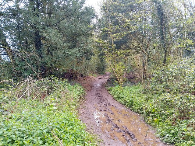
Eastern Plantation offers a network of well-maintained trails that wind through the woodland, providing visitors with the opportunity to explore the plantation's natural wonders. These trails cater to a range of abilities, from leisurely strolls to more challenging hikes, ensuring there is something for everyone to enjoy.

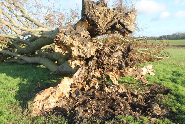
In addition to its natural beauty, Eastern Plantation also has a rich history. The area was once utilized for timber production, and remnants of old sawmills and charcoal pits can still be found within the woodland. These historical artifacts serve as a testament to the plantation's past and provide a glimpse into the region's industrial heritage.

Eastern Plantation is a true gem nestled in the heart of Wiltshire. Its stunning woodlands, diverse wildlife, and rich history make it a must-visit destination for those seeking a peaceful and immersive experience in nature.

If you have any feedback on the listing, please let us know in the comments section below.

Eastern Plantation Images

Images are sourced within 2km of 51.172303/-1.6802164 or Grid Reference SU2241. Thanks to Geograph Open Source API. All images are credited.

Outdoor Seating Area, Cholderton Farm Shop and Cafe
Home Farm, Cholderton The farm boasts the popular Cholderton Farm Shop and Cafe. The shepherd's hut hasn't altered much in 10 years <a href="https://www.geograph.org.uk/photo/2834040">SU2342 : Drive, Home Farm</a>.
Home Farm, Cholderton
The farm boasts the popular Cholderton Farm Shop and Cafe. The shepherd's hut hasn't altered much in 10 years SU2342 : Drive, Home Farm.
Quarley Parish Boundary Marker The boundary stone marks the south-west corner of Quarley parish. It is inscribed on the west face "QM 1807".
Quarley Parish Boundary Marker
The boundary stone marks the south-west corner of Quarley parish. It is inscribed on the west face "QM 1807".
Quarley Parish Boundary Marker Stone boundary marker, east face, inscribed with Ordnance Survey benchmark and with metal stud set in the top surface.
Quarley Parish Boundary Marker
Stone boundary marker, east face, inscribed with Ordnance Survey benchmark and with metal stud set in the top surface.
Big Cowden field, Cholderton, fallen tree Fallen tree (with arborglyph - see earlier photo <a title="https://www.geograph.org.uk/photo/6054096)" href="https://www.geograph.org.uk/photo/6054096)">Link</a>
Big Cowden field, Cholderton, fallen tree
Fallen tree (with arborglyph - see earlier photo Link
Tin Can Copse, Cholderton Tin Can Copse is a sad remnant of a small copse of trees situated on the boundary of Big Cowden field and the edge of the Bourne valley floodplain. It gets its name from the hollow in the middle being used as a rubbish dump during the mid/late 19th-early/mid 20th century.
Tin Can Copse, Cholderton
Tin Can Copse is a sad remnant of a small copse of trees situated on the boundary of Big Cowden field and the edge of the Bourne valley floodplain. It gets its name from the hollow in the middle being used as a rubbish dump during the mid/late 19th-early/mid 20th century.
Big Cowden field, Cholderton, fallen tree The northern and first to fall of two trees in the middle of Big Cowden field (the tree on the left in <a title="https://www.geograph.org.uk/photo/6054093)" href="https://www.geograph.org.uk/photo/6054093)">Link</a>. The uprooted tree bowl shows the underlying soliflucted chalk overlain by Clay-with-flints still attached to the roots.
Big Cowden field, Cholderton, fallen tree
The northern and first to fall of two trees in the middle of Big Cowden field (the tree on the left in Link. The uprooted tree bowl shows the underlying soliflucted chalk overlain by Clay-with-flints still attached to the roots.
Down Barn Dairy field, Cholderton during field walking survey Looking west across the combe running through Down Barn Dairy field, during archaeological field walking survey in advance of solar development due to cover the field in the future.
Down Barn Dairy field, Cholderton during field walking survey
Looking west across the combe running through Down Barn Dairy field, during archaeological field walking survey in advance of solar development due to cover the field in the future.
Parkhouse Field, Cholderton Looking across Top Parkhouse Field to Beacon Hill, with tractor and water trough.
Parkhouse Field, Cholderton
Looking across Top Parkhouse Field to Beacon Hill, with tractor and water trough.
Grateley Lodge Grateley Lodge is a lodge at the end of a lane. The lodge is part of Wilbury House (a Grade II listed park and garden), list entry number 1001245 <span class="nowrap"><a title="https://historicengland.org.uk/listing/the-list/list-entry/1001245" rel="nofollow ugc noopener" href="https://historicengland.org.uk/listing/the-list/list-entry/1001245">Link</a><img style="margin-left:2px;" alt="External link" title="External link - shift click to open in new window" src="https://s1.geograph.org.uk/img/external.png" width="10" height="10"/></span>
Grateley Lodge
Grateley Lodge is a lodge at the end of a lane. The lodge is part of Wilbury House (a Grade II listed park and garden), list entry number 1001245 LinkExternal link
Byway towards Grateley Lodge A byway heading towards Grateley Lodge.
Byway towards Grateley Lodge
A byway heading towards Grateley Lodge.
Field south east of Grateley Lodge A field to the south east of Grateley Lodge.
Field south east of Grateley Lodge
A field to the south east of Grateley Lodge.
Long Walk Plantation track A track through Long Walk Plantation.
Long Walk Plantation track
A track through Long Walk Plantation.
Farmland east of Long Walk Plantation Farmland to the east of Long Walk Plantation.
Farmland east of Long Walk Plantation
Farmland to the east of Long Walk Plantation.
Bridleway sign at Long Walk Plantation A bridleway sign on the edge of Long Walk Plantation, fixed to a telegraph pole.
Bridleway sign at Long Walk Plantation
A bridleway sign on the edge of Long Walk Plantation, fixed to a telegraph pole.
Long Walk Plantation track A track through Long Walk Plantation.
Long Walk Plantation track
A track through Long Walk Plantation.
St Andrew, Newton Toney: September 2023
St Andrew, Newton Toney: grave of a baronet That of Sir Henry Charles Eden Malet, 3rd Baronet. His father <span class="nowrap"><a title="https://en.wikipedia.org/wiki/Sir_Alexander_Malet,_2nd_Baronet" rel="nofollow ugc noopener" href="https://en.wikipedia.org/wiki/Sir_Alexander_Malet,_2nd_Baronet">Link</a><img style="margin-left:2px;" alt="External link" title="External link - shift click to open in new window" src="https://s1.geograph.org.uk/img/external.png" width="10" height="10"/></span> and son <span class="nowrap"><a title="https://en.wikipedia.org/wiki/Edward_Malet" rel="nofollow ugc noopener" href="https://en.wikipedia.org/wiki/Edward_Malet">Link</a><img style="margin-left:2px;" alt="External link" title="External link - shift click to open in new window" src="https://s1.geograph.org.uk/img/external.png" width="10" height="10"/></span> have Wikipedia entries.
St Andrew, Newton Toney: grave of a baronet
That of Sir Henry Charles Eden Malet, 3rd Baronet. His father LinkExternal link and son LinkExternal link have Wikipedia entries.
Show me another place!

Eastern Plantation is located at Grid Ref: SU2241 (Lat: 51.172303, Lng: -1.6802164)

Unitary Authority: Wiltshire

Police Authority: Wiltshire

What 3 Words

///tumblers.sandwich.spit. Near Allington, Wiltshire

Related Wikis

Wilbury House

Wilbury House or Wilbury Park is an 18th-century Neo-Palladian country house in the parish of Newton Tony, Wiltshire in South West England, about 8.7 miles...

Cholderton

Cholderton, or more properly West Cholderton, is a village and civil parish in the Bourne Valley of Wiltshire, England. The village is about 4 miles (6...

Newton Tony

Newton Tony (formerly Newton Toney) is a rural English village and civil parish in the county of Wiltshire, close to the border with Hampshire. Situated...

Battle of the Beanfield

The Battle of the Beanfield took place over several hours on 1 June 1985, when Wiltshire Police prevented The Peace Convoy, a convoy of several hundred...

Nearby Amenities

Located within 500m of 51.172303,-1.6802164
The data included in this document is from www.openstreetmap.org. The data is made available under ODbL.

Have you been to Eastern Plantation?

Leave your review of Eastern Plantation below (or comments, questions and feedback).