Coronation Plantation
Wood, Forest in Yorkshire Richmondshire
England
Coronation Plantation
Coronation Plantation, located in Yorkshire, is a picturesque woodland area known for its lush greenery and diverse range of trees. This enchanting forest covers a vast expanse of land, providing visitors with a tranquil escape from the hustle and bustle of everyday life.
The plantation is home to a variety of tree species, including oak, beech, and birch, which create a beautiful tapestry of colors throughout the seasons. The dense canopy of foliage offers a cool respite during the hot summer months, while in autumn, the vibrant hues of red, orange, and gold create a breathtaking display.
Walking trails wind their way through the plantation, allowing visitors to explore the woodland at their own pace. These paths are well-maintained and offer a chance to immerse oneself in the natural beauty of the surroundings. The tranquil atmosphere is enhanced by the gentle rustling of leaves and the melodic songs of birds.
Coronation Plantation is not only a haven for nature lovers but also a habitat for various wildlife species. Keen observers may spot squirrels scampering among the branches or catch a glimpse of a deer gracefully moving through the undergrowth.
The plantation is a popular destination for outdoor activities such as hiking, birdwatching, and photography. It also offers opportunities for picnics and family outings, with designated areas equipped with tables and benches.
With its stunning scenery, diverse flora and fauna, and peaceful ambiance, Coronation Plantation in Yorkshire is a must-visit destination for those seeking a connection with nature and a chance to unwind in a truly enchanting setting.
If you have any feedback on the listing, please let us know in the comments section below.
Coronation Plantation Images
Images are sourced within 2km of 54.52027/-1.6643333 or Grid Reference NZ2113. Thanks to Geograph Open Source API. All images are credited.


![Piercebridge Roman features [1] This information board about the Roman Bridge is located in the car park.
Piercebridge is a village in the county of Durham, some 5 miles west of Darlington. The village overlies a Roman fort built circa 265 where Dere Street, the Roman road from York to Newstead, crossed the River Tees. The fort was occupied until the fifth century and a civilian settlement was established to the east of the fort. The river has changed course and the remains of a Roman bridge over the river lie about a quarter of a mile east of the current bridge. Most of the site of the village is a Scheduled Ancient Monument, with details at: <span class="nowrap"><a title="https://historicengland.org.uk/listing/the-list/list-entry/1002365" rel="nofollow ugc noopener" href="https://historicengland.org.uk/listing/the-list/list-entry/1002365">Link</a><img style="margin-left:2px;" alt="External link" title="External link - shift click to open in new window" src="https://s1.geograph.org.uk/img/external.png" width="10" height="10"/></span>](https://s0.geograph.org.uk/geophotos/07/31/89/7318920_88671c65.jpg)
![Piercebridge features [1] This path leads to the remains of the Roman bridge.
Piercebridge is a village in the county of Durham, some 5 miles west of Darlington. The village overlies a Roman fort built circa 265 where Dere Street, the Roman road from York to Newstead, crossed the River Tees. The fort was occupied until the fifth century and a civilian settlement was established to the east of the fort. The river has changed course and the remains of a Roman bridge over the river lie about a quarter of a mile east of the current bridge. Most of the site of the village is a Scheduled Ancient Monument, with details at: <span class="nowrap"><a title="https://historicengland.org.uk/listing/the-list/list-entry/1002365" rel="nofollow ugc noopener" href="https://historicengland.org.uk/listing/the-list/list-entry/1002365">Link</a><img style="margin-left:2px;" alt="External link" title="External link - shift click to open in new window" src="https://s1.geograph.org.uk/img/external.png" width="10" height="10"/></span>](https://s1.geograph.org.uk/geophotos/07/31/89/7318921_7bafcd77.jpg)
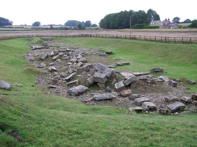
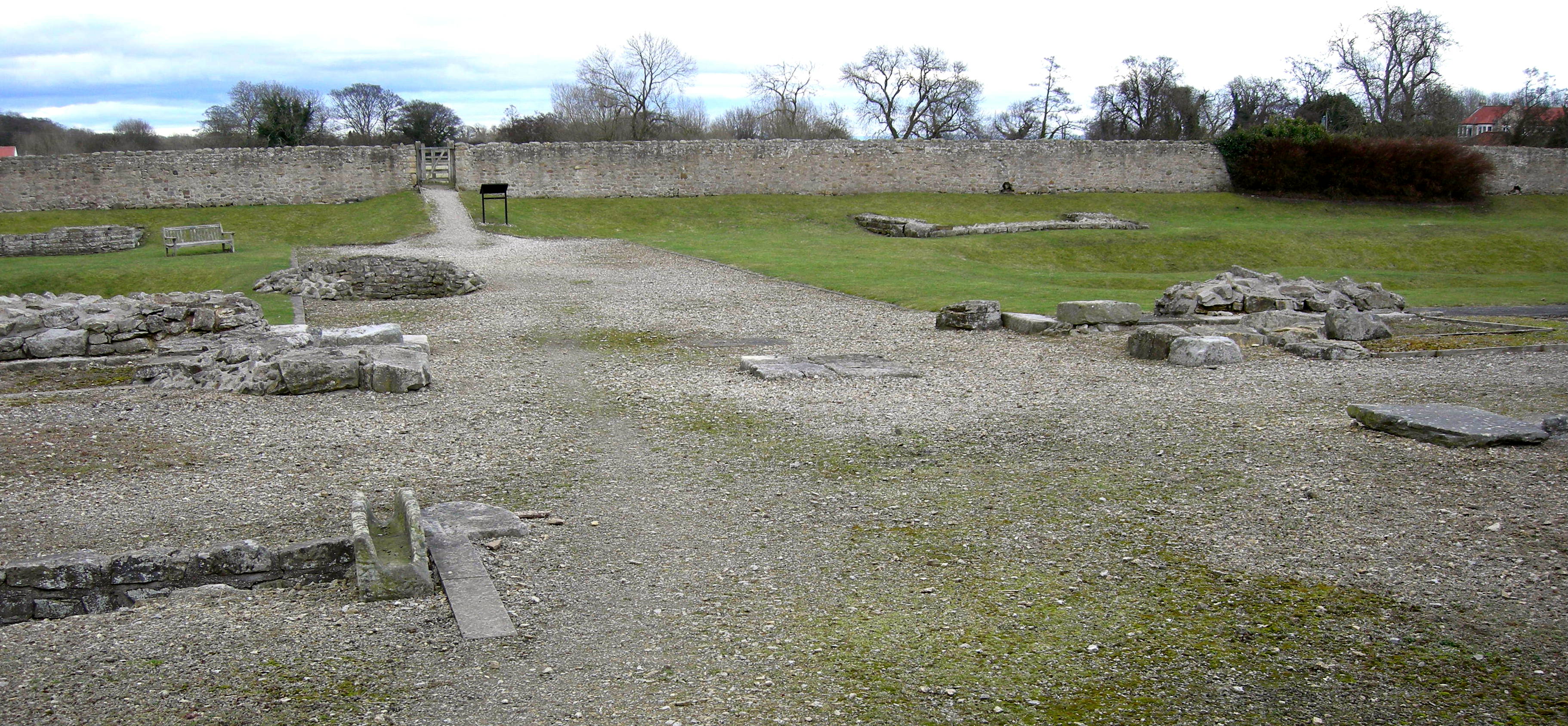
![Piercebridge Roman features [2] The original Roman timber bridge was destroyed in a flood and a replacement stone bridge was built some 200 metres downstream. The river has since changed course and the remains of the stone bridge, seen here, were discovered in the 1970s. The site is a Scheduled Ancient Monument with details at: <span class="nowrap"><a title="https://historicengland.org.uk/listing/the-list/list-entry/1004062" rel="nofollow ugc noopener" href="https://historicengland.org.uk/listing/the-list/list-entry/1004062">Link</a><img style="margin-left:2px;" alt="External link" title="External link - shift click to open in new window" src="https://s1.geograph.org.uk/img/external.png" width="10" height="10"/></span>
Piercebridge is a village in the county of Durham, some 5 miles west of Darlington. The village overlies a Roman fort built circa 265 where Dere Street, the Roman road from York to Newstead, crossed the River Tees. The fort was occupied until the fifth century and a civilian settlement was established to the east of the fort. The river has changed course and the remains of a Roman bridge over the river lie about a quarter of a mile east of the current bridge. Most of the site of the village is a Scheduled Ancient Monument, with details at: <span class="nowrap"><a title="https://historicengland.org.uk/listing/the-list/list-entry/1002365" rel="nofollow ugc noopener" href="https://historicengland.org.uk/listing/the-list/list-entry/1002365">Link</a><img style="margin-left:2px;" alt="External link" title="External link - shift click to open in new window" src="https://s1.geograph.org.uk/img/external.png" width="10" height="10"/></span>](https://s2.geograph.org.uk/geophotos/07/31/89/7318922_4fbb09c8.jpg)
![Piercebridge Roman features [3] The original Roman timber bridge was destroyed in a flood and a replacement stone bridge was built some 200 metres downstream. The river has since changed course and the remains of the stone bridge, seen here, were discovered in the 1970s. The site is a Scheduled Ancient Monument with details at: <span class="nowrap"><a title="https://historicengland.org.uk/listing/the-list/list-entry/1004062" rel="nofollow ugc noopener" href="https://historicengland.org.uk/listing/the-list/list-entry/1004062">Link</a><img style="margin-left:2px;" alt="External link" title="External link - shift click to open in new window" src="https://s1.geograph.org.uk/img/external.png" width="10" height="10"/></span>
Piercebridge is a village in the county of Durham, some 5 miles west of Darlington. The village overlies a Roman fort built circa 265 where Dere Street, the Roman road from York to Newstead, crossed the River Tees. The fort was occupied until the fifth century and a civilian settlement was established to the east of the fort. The river has changed course and the remains of a Roman bridge over the river lie about a quarter of a mile east of the current bridge. Most of the site of the village is a Scheduled Ancient Monument, with details at: <span class="nowrap"><a title="https://historicengland.org.uk/listing/the-list/list-entry/1002365" rel="nofollow ugc noopener" href="https://historicengland.org.uk/listing/the-list/list-entry/1002365">Link</a><img style="margin-left:2px;" alt="External link" title="External link - shift click to open in new window" src="https://s1.geograph.org.uk/img/external.png" width="10" height="10"/></span>](https://s0.geograph.org.uk/geophotos/07/31/89/7318924_111a4246.jpg)
![Piercebridge Roman features [4] The original Roman timber bridge was destroyed in a flood and a replacement stone bridge was built some 200 metres downstream. The river has since changed course and the remains of the stone bridge, seen here, were discovered in the 1970s. The site is a Scheduled Ancient Monument with details at: <span class="nowrap"><a title="https://historicengland.org.uk/listing/the-list/list-entry/1004062" rel="nofollow ugc noopener" href="https://historicengland.org.uk/listing/the-list/list-entry/1004062">Link</a><img style="margin-left:2px;" alt="External link" title="External link - shift click to open in new window" src="https://s1.geograph.org.uk/img/external.png" width="10" height="10"/></span>
Piercebridge is a village in the county of Durham, some 5 miles west of Darlington. The village overlies a Roman fort built circa 265 where Dere Street, the Roman road from York to Newstead, crossed the River Tees. The fort was occupied until the fifth century and a civilian settlement was established to the east of the fort. The river has changed course and the remains of a Roman bridge over the river lie about a quarter of a mile east of the current bridge. Most of the site of the village is a Scheduled Ancient Monument, with details at: <span class="nowrap"><a title="https://historicengland.org.uk/listing/the-list/list-entry/1002365" rel="nofollow ugc noopener" href="https://historicengland.org.uk/listing/the-list/list-entry/1002365">Link</a><img style="margin-left:2px;" alt="External link" title="External link - shift click to open in new window" src="https://s1.geograph.org.uk/img/external.png" width="10" height="10"/></span>](https://s3.geograph.org.uk/geophotos/07/31/89/7318927_206de143.jpg)
![Piercebridge Roman features [5] The original Roman timber bridge was destroyed in a flood and a replacement stone bridge was built some 200 metres downstream. The river has since changed course and the remains of the stone bridge, seen here, were discovered in the 1970s. The site is a Scheduled Ancient Monument with details at: <span class="nowrap"><a title="https://historicengland.org.uk/listing/the-list/list-entry/1004062" rel="nofollow ugc noopener" href="https://historicengland.org.uk/listing/the-list/list-entry/1004062">Link</a><img style="margin-left:2px;" alt="External link" title="External link - shift click to open in new window" src="https://s1.geograph.org.uk/img/external.png" width="10" height="10"/></span>
Piercebridge is a village in the county of Durham, some 5 miles west of Darlington. The village overlies a Roman fort built circa 265 where Dere Street, the Roman road from York to Newstead, crossed the River Tees. The fort was occupied until the fifth century and a civilian settlement was established to the east of the fort. The river has changed course and the remains of a Roman bridge over the river lie about a quarter of a mile east of the current bridge. Most of the site of the village is a Scheduled Ancient Monument, with details at: <span class="nowrap"><a title="https://historicengland.org.uk/listing/the-list/list-entry/1002365" rel="nofollow ugc noopener" href="https://historicengland.org.uk/listing/the-list/list-entry/1002365">Link</a><img style="margin-left:2px;" alt="External link" title="External link - shift click to open in new window" src="https://s1.geograph.org.uk/img/external.png" width="10" height="10"/></span>](https://s3.geograph.org.uk/geophotos/07/31/89/7318931_745ef86e.jpg)
![Piercebridge Roman features [6] The original Roman timber bridge was destroyed in a flood and a replacement stone bridge was built some 200 metres downstream. The river has since changed course and the remains of the stone bridge, seen here, were discovered in the 1970s. The site is a Scheduled Ancient Monument with details at: <span class="nowrap"><a title="https://historicengland.org.uk/listing/the-list/list-entry/1004062" rel="nofollow ugc noopener" href="https://historicengland.org.uk/listing/the-list/list-entry/1004062">Link</a><img style="margin-left:2px;" alt="External link" title="External link - shift click to open in new window" src="https://s1.geograph.org.uk/img/external.png" width="10" height="10"/></span>
Piercebridge is a village in the county of Durham, some 5 miles west of Darlington. The village overlies a Roman fort built circa 265 where Dere Street, the Roman road from York to Newstead, crossed the River Tees. The fort was occupied until the fifth century and a civilian settlement was established to the east of the fort. The river has changed course and the remains of a Roman bridge over the river lie about a quarter of a mile east of the current bridge. Most of the site of the village is a Scheduled Ancient Monument, with details at: <span class="nowrap"><a title="https://historicengland.org.uk/listing/the-list/list-entry/1002365" rel="nofollow ugc noopener" href="https://historicengland.org.uk/listing/the-list/list-entry/1002365">Link</a><img style="margin-left:2px;" alt="External link" title="External link - shift click to open in new window" src="https://s1.geograph.org.uk/img/external.png" width="10" height="10"/></span>](https://s1.geograph.org.uk/geophotos/07/31/89/7318933_034b3441.jpg)
![Piercebridge features [2] This path leads back to the village from the remains of the Roman bridge.
Piercebridge is a village in the county of Durham, some 5 miles west of Darlington. The village overlies a Roman fort built circa 265 where Dere Street, the Roman road from York to Newstead, crossed the River Tees. The fort was occupied until the fifth century and a civilian settlement was established to the east of the fort. The river has changed course and the remains of a Roman bridge over the river lie about a quarter of a mile east of the current bridge. Most of the site of the village is a Scheduled Ancient Monument, with details at: <span class="nowrap"><a title="https://historicengland.org.uk/listing/the-list/list-entry/1002365" rel="nofollow ugc noopener" href="https://historicengland.org.uk/listing/the-list/list-entry/1002365">Link</a><img style="margin-left:2px;" alt="External link" title="External link - shift click to open in new window" src="https://s1.geograph.org.uk/img/external.png" width="10" height="10"/></span>](https://s0.geograph.org.uk/geophotos/07/31/89/7318936_9a643aa7.jpg)
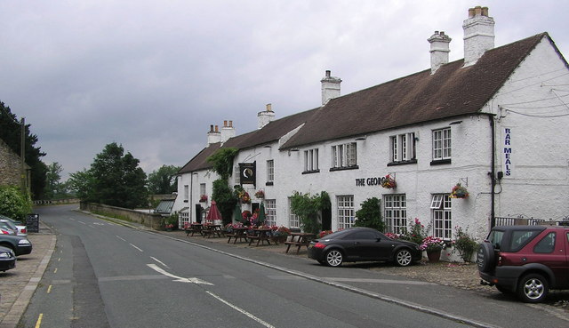
![Piercebridge buildings [1] A former coaching inn, the George Hotel has ranges from the 17th, 18th and 19th centuries, with later alterations and additions. Constructed of rendered rubble stone under tile roofs. The 17th century range is on the left, the 18th century range is in the centre and the 19th century range is to the right. Some early original internal features remain. Listed, grade II, with details at: <span class="nowrap"><a title="https://historicengland.org.uk/listing/the-list/list-entry/1179351" rel="nofollow ugc noopener" href="https://historicengland.org.uk/listing/the-list/list-entry/1179351">Link</a><img style="margin-left:2px;" alt="External link" title="External link - shift click to open in new window" src="https://s1.geograph.org.uk/img/external.png" width="10" height="10"/></span>
Piercebridge is a village in the county of Durham, some 5 miles west of Darlington. The village overlies a Roman fort built circa 265 where Dere Street, the Roman road from York to Newstead, crossed the River Tees. The fort was occupied until the fifth century and a civilian settlement was established to the east of the fort. The river has changed course and the remains of a Roman bridge over the river lie about a quarter of a mile east of the current bridge. Most of the site of the village is a Scheduled Ancient Monument, with details at: <span class="nowrap"><a title="https://historicengland.org.uk/listing/the-list/list-entry/1002365" rel="nofollow ugc noopener" href="https://historicengland.org.uk/listing/the-list/list-entry/1002365">Link</a><img style="margin-left:2px;" alt="External link" title="External link - shift click to open in new window" src="https://s1.geograph.org.uk/img/external.png" width="10" height="10"/></span>](https://s1.geograph.org.uk/geophotos/07/31/89/7318949_b170d441.jpg)
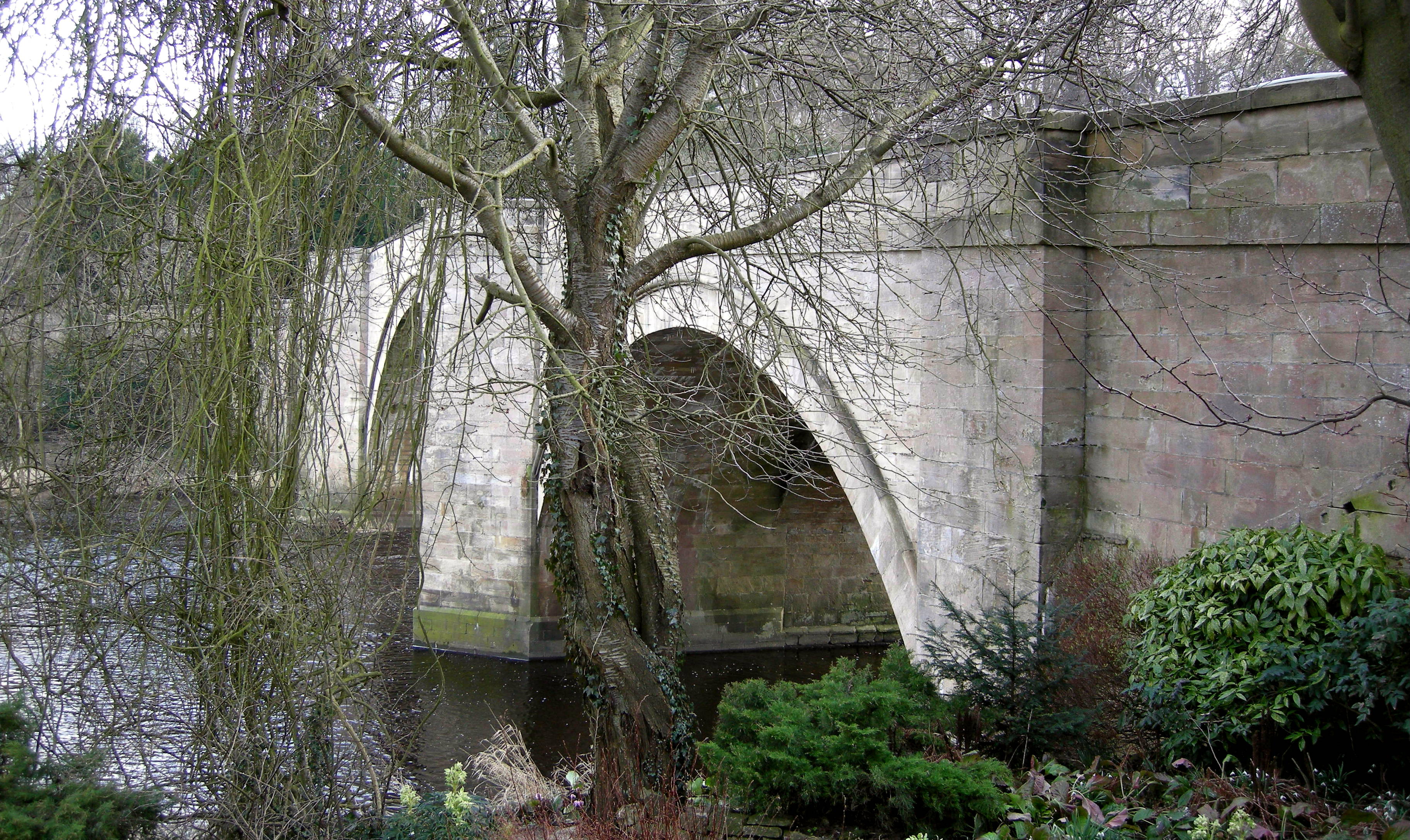
![Piercebridge features [3] Piercebridge Bridge carries the B6275 road over the River Tees. The bridge was built in the early 16th century and widened on the downstream side in 1781. Constructed of dressed and ashlar sandstone. Both sides have cutwaters rising to form pedestrian refuges. See also <a href="https://www.geograph.org.uk/photo/7319718">NZ2115 : Piercebridge features [4]</a> Listed, grade II*, with details at: <span class="nowrap"><a title="https://historicengland.org.uk/listing/the-list/list-entry/1145843" rel="nofollow ugc noopener" href="https://historicengland.org.uk/listing/the-list/list-entry/1145843">Link</a><img style="margin-left:2px;" alt="External link" title="External link - shift click to open in new window" src="https://s1.geograph.org.uk/img/external.png" width="10" height="10"/></span> A Scheduled Ancient Monument with details at: <span class="nowrap"><a title="https://historicengland.org.uk/listing/the-list/list-entry/1002344" rel="nofollow ugc noopener" href="https://historicengland.org.uk/listing/the-list/list-entry/1002344">Link</a><img style="margin-left:2px;" alt="External link" title="External link - shift click to open in new window" src="https://s1.geograph.org.uk/img/external.png" width="10" height="10"/></span>
Piercebridge is a village in the county of Durham, some 5 miles west of Darlington. The village overlies a Roman fort built circa 265 where Dere Street, the Roman road from York to Newstead, crossed the River Tees. The fort was occupied until the fifth century and a civilian settlement was established to the east of the fort. The river has changed course and the remains of a Roman bridge over the river lie about a quarter of a mile east of the current bridge. Most of the site of the village is a Scheduled Ancient Monument, with details at: <span class="nowrap"><a title="https://historicengland.org.uk/listing/the-list/list-entry/1002365" rel="nofollow ugc noopener" href="https://historicengland.org.uk/listing/the-list/list-entry/1002365">Link</a><img style="margin-left:2px;" alt="External link" title="External link - shift click to open in new window" src="https://s1.geograph.org.uk/img/external.png" width="10" height="10"/></span>](https://s1.geograph.org.uk/geophotos/07/31/97/7319717_3c8ee19b.jpg)
![Piercebridge features [4] Piercebridge Bridge carries the B6275 road over the River Tees. The bridge was built in the early 16th century and widened on the downstream side in 1781. Constructed of dressed and ashlar sandstone. Both sides have cutwaters rising to form pedestrian refuges. See also <a href="https://www.geograph.org.uk/photo/7319717">NZ2115 : Piercebridge features [3]</a> Listed, grade II*, with details at: <span class="nowrap"><a title="https://historicengland.org.uk/listing/the-list/list-entry/1145843" rel="nofollow ugc noopener" href="https://historicengland.org.uk/listing/the-list/list-entry/1145843">Link</a><img style="margin-left:2px;" alt="External link" title="External link - shift click to open in new window" src="https://s1.geograph.org.uk/img/external.png" width="10" height="10"/></span> A Scheduled Ancient Monument with details at: <span class="nowrap"><a title="https://historicengland.org.uk/listing/the-list/list-entry/1002344" rel="nofollow ugc noopener" href="https://historicengland.org.uk/listing/the-list/list-entry/1002344">Link</a><img style="margin-left:2px;" alt="External link" title="External link - shift click to open in new window" src="https://s1.geograph.org.uk/img/external.png" width="10" height="10"/></span>
Piercebridge is a village in the county of Durham, some 5 miles west of Darlington. The village overlies a Roman fort built circa 265 where Dere Street, the Roman road from York to Newstead, crossed the River Tees. The fort was occupied until the fifth century and a civilian settlement was established to the east of the fort. The river has changed course and the remains of a Roman bridge over the river lie about a quarter of a mile east of the current bridge. Most of the site of the village is a Scheduled Ancient Monument, with details at: <span class="nowrap"><a title="https://historicengland.org.uk/listing/the-list/list-entry/1002365" rel="nofollow ugc noopener" href="https://historicengland.org.uk/listing/the-list/list-entry/1002365">Link</a><img style="margin-left:2px;" alt="External link" title="External link - shift click to open in new window" src="https://s1.geograph.org.uk/img/external.png" width="10" height="10"/></span>](https://s2.geograph.org.uk/geophotos/07/31/97/7319718_609a1c9d.jpg)
![Piercebridge features [5] The River Tees, looking upstream from Piercebridge Bridge <a href="https://www.geograph.org.uk/photo/7319717">NZ2115 : Piercebridge features [3]</a> and <a href="https://www.geograph.org.uk/photo/7319718">NZ2115 : Piercebridge features [4]</a>.
Piercebridge is a village in the county of Durham, some 5 miles west of Darlington. The village overlies a Roman fort built circa 265 where Dere Street, the Roman road from York to Newstead, crossed the River Tees. The fort was occupied until the fifth century and a civilian settlement was established to the east of the fort. The river has changed course and the remains of a Roman bridge over the river lie about a quarter of a mile east of the current bridge. Most of the site of the village is a Scheduled Ancient Monument, with details at: <span class="nowrap"><a title="https://historicengland.org.uk/listing/the-list/list-entry/1002365" rel="nofollow ugc noopener" href="https://historicengland.org.uk/listing/the-list/list-entry/1002365">Link</a><img style="margin-left:2px;" alt="External link" title="External link - shift click to open in new window" src="https://s1.geograph.org.uk/img/external.png" width="10" height="10"/></span>](https://s3.geograph.org.uk/geophotos/07/31/97/7319719_5d028d08.jpg)
![Piercebridge features [6] The River Tees, looking downstream from Piercebridge Bridge <a href="https://www.geograph.org.uk/photo/7319717">NZ2115 : Piercebridge features [3]</a> and <a href="https://www.geograph.org.uk/photo/7319718">NZ2115 : Piercebridge features [4]</a>.
Piercebridge is a village in the county of Durham, some 5 miles west of Darlington. The village overlies a Roman fort built circa 265 where Dere Street, the Roman road from York to Newstead, crossed the River Tees. The fort was occupied until the fifth century and a civilian settlement was established to the east of the fort. The river has changed course and the remains of a Roman bridge over the river lie about a quarter of a mile east of the current bridge. Most of the site of the village is a Scheduled Ancient Monument, with details at: <span class="nowrap"><a title="https://historicengland.org.uk/listing/the-list/list-entry/1002365" rel="nofollow ugc noopener" href="https://historicengland.org.uk/listing/the-list/list-entry/1002365">Link</a><img style="margin-left:2px;" alt="External link" title="External link - shift click to open in new window" src="https://s1.geograph.org.uk/img/external.png" width="10" height="10"/></span>](https://s0.geograph.org.uk/geophotos/07/31/97/7319720_d4d1f062.jpg)
Coronation Plantation is located at Grid Ref: NZ2113 (Lat: 54.52027, Lng: -1.6643333)
Division: North Riding
Administrative County: North Yorkshire
District: Richmondshire
Police Authority: North Yorkshire
What 3 Words
///compiled.sedative.pylons. Near High Coniscliffe, Co. Durham
Nearby Locations
Related Wikis

Manfield
Manfield is a village and civil parish in the Richmondshire district of North Yorkshire, England. It is a parish in the wapentake of Gilling East. The...
Cliffe, Richmondshire
Cliffe is a small village and civil parish in Richmondshire district of North Yorkshire, England. A stream called the Glen runs through the village to...
Battle of Piercebridge
The battle of Piercebridge was fought on 1 December 1642 in County Durham, England, during the First English Civil War. The Earl of Newcastle was advancing...
Piercebridge Roman Bridge
Piercebridge Roman Bridge is the ruin of a Roman bridge over the River Tees, northern England. It is near the villages of Cliffe (North Yorkshire) and...
Piercebridge Roman Fort
Piercebridge Roman Fort is a scheduled ancient monument situated in the village of Piercebridge on the banks of the River Tees in modern-day County Durham...
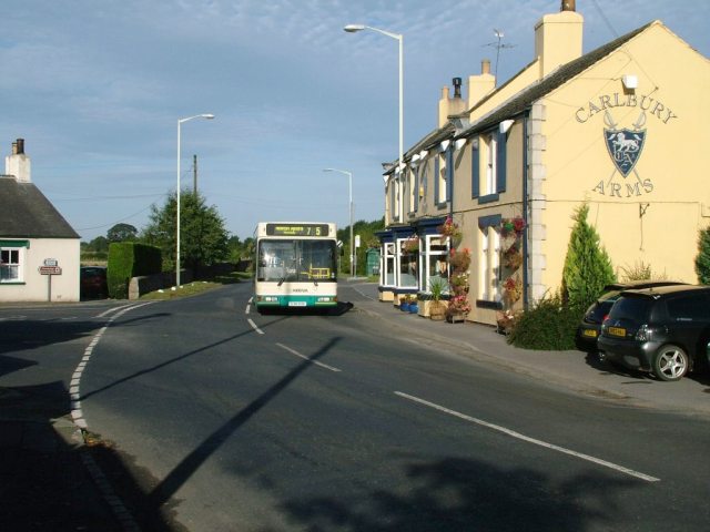
Carlbury
Carlbury is a hamlet in the civil parish of High Coniscliffe in County Durham, in England. It is situated a few miles to the west of Darlington, on the...

A67 road
The A67 is a road in England that links Bowes in County Durham with Crathorne in North Yorkshire. The road from Middlesbrough to Darlington was previously...
Piercebridge
Piercebridge is a village and civil parish in the borough of Darlington and the ceremonial county of Durham, England. The population of the civil parish...
Nearby Amenities
Located within 500m of 54.52027,-1.6643333Have you been to Coronation Plantation?
Leave your review of Coronation Plantation below (or comments, questions and feedback).