Coldbeck's Plantation

Wood, Forest in Yorkshire Harrogate

England

Coldbeck's Plantation

Kirk Bank Minor lane heading west from Kirkby Malzeard.
Kirk Bank Credit: Chris Heaton

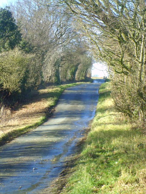
Coldbeck's Plantation is a picturesque woodland area located in the county of Yorkshire, England. Situated in the northern part of the county, the plantation covers a vast area of land, forming part of the larger forested region in the vicinity. The plantation is renowned for its stunning natural beauty, with dense trees and lush vegetation encompassing the landscape.

The woodland is primarily composed of a diverse range of tree species, including oak, beech, and birch, creating a rich and vibrant ecosystem. The area is also home to a variety of wildlife, including deer, rabbits, and various bird species, making it a popular spot for nature enthusiasts and birdwatchers.

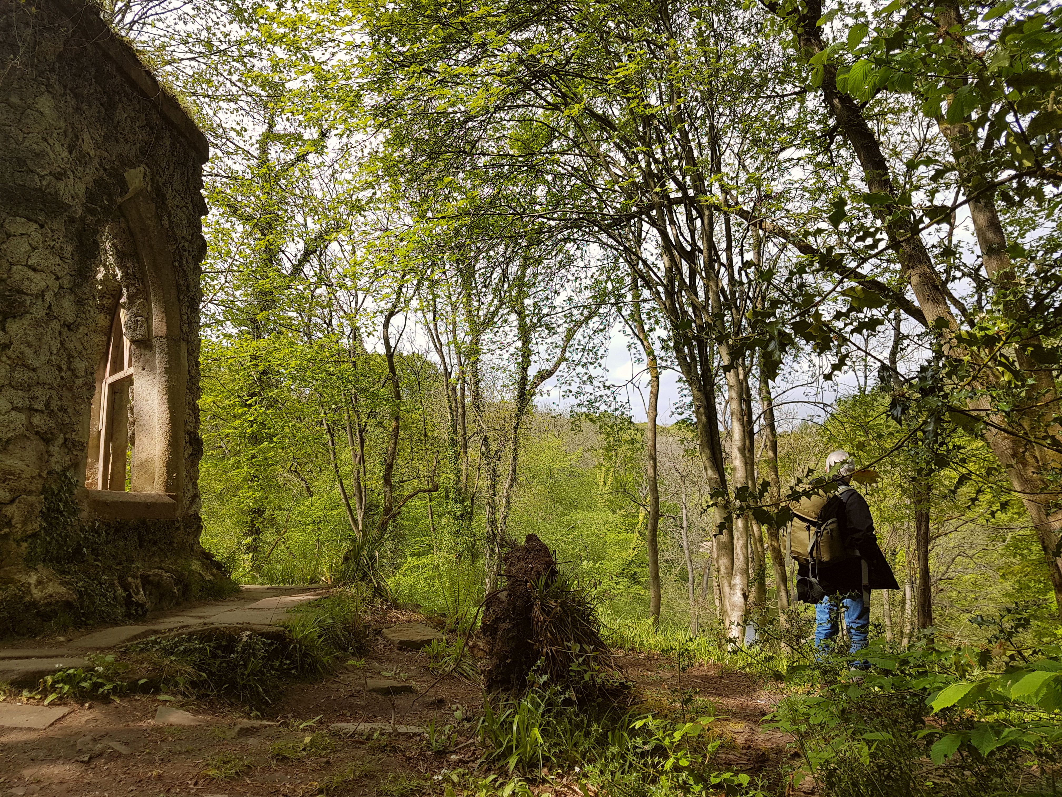
Coldbeck's Plantation offers a tranquil and serene environment, attracting visitors who seek solace and relaxation amidst nature. Numerous walking trails meander through the woodland, offering opportunities for exploration and discovery. These paths provide an excellent way to admire the flora and fauna, with occasional clearings offering breathtaking views of the surrounding countryside.

The plantation is well-maintained, with efforts made to preserve its natural beauty and protect its inhabitants. The management of the area ensures that the woodland remains a haven for wildlife and an enjoyable destination for visitors. Conservation initiatives are in place to safeguard the biodiversity of the plantation, ensuring its longevity for future generations to appreciate.

Coldbeck's Plantation is a must-visit destination for those seeking a slice of tranquility in the heart of Yorkshire. Its stunning landscape, diverse wildlife, and well-preserved natural environment make it a true gem of the region.

If you have any feedback on the listing, please let us know in the comments section below.

Coldbeck's Plantation Images

Images are sourced within 2km of 54.163601/-1.6729522 or Grid Reference SE2174. Thanks to Geograph Open Source API. All images are credited.

Kirk Bank Minor lane heading west from Kirkby Malzeard.
Kirk Bank
Minor lane heading west from Kirkby Malzeard.
Foulgate Nook Lane Access to Foulgate Farm from Grewelthorpe.
Foulgate Nook Lane
Access to Foulgate Farm from Grewelthorpe.
Access Lane to Thorpe Grange Tarmaced access lane leading off Foulgate Nook Lane towards Thorpe Grange.
Access Lane to Thorpe Grange
Tarmaced access lane leading off Foulgate Nook Lane towards Thorpe Grange.
Road Junction, Kirkby Malzeard Road junction at the western end of Kirkby Malzeard village.
Road Junction, Kirkby Malzeard
Road junction at the western end of Kirkby Malzeard village.
Entering Kirkby Malzeard Entering the village from Laverton.
Entering Kirkby Malzeard
Entering the village from Laverton.
Parked Up Old Ford tractor with a trailer full of stone parked up outside Foulgate Farm.
Parked Up
Old Ford tractor with a trailer full of stone parked up outside Foulgate Farm.
Main Street Kirkby Malzeard A springtime view along the Main Street of Kirkby Malzeard.
Main Street Kirkby Malzeard
A springtime view along the Main Street of Kirkby Malzeard.
Bridleway to Kirkby Malzeard Bridleway from Foulgate to Kirkby Malzeard. This is probably an ancient track dating back to the medieval period when Kirkby was a market centre. The bridleway provides a through route to Lofthouse and upper Nidderdale.
Bridleway to Kirkby Malzeard
Bridleway from Foulgate to Kirkby Malzeard. This is probably an ancient track dating back to the medieval period when Kirkby was a market centre. The bridleway provides a through route to Lofthouse and upper Nidderdale.
Footbridge over Kex Beck Footbridge and ford at Kex Beck to the west of Kirkby Malzeard.
Footbridge over Kex Beck
Footbridge and ford at Kex Beck to the west of Kirkby Malzeard.
Tractors at work Ploughing fields to the west of Kirkby Malzeard.
Tractors at work
Ploughing fields to the west of Kirkby Malzeard.
Holmes Farm Holmes Farm stands amongst pastureland to the west of Kirkby Malzeard.
Holmes Farm
Holmes Farm stands amongst pastureland to the west of Kirkby Malzeard.
Duck pond, Foulgate A recently constructed duck pond, complete with smart duck house on an island.
Duck pond, Foulgate
A recently constructed duck pond, complete with smart duck house on an island.
Wreaks Lane Unsurfaced lane heading gently downhill towards Grewelthorpe.
Wreaks Lane
Unsurfaced lane heading gently downhill towards Grewelthorpe.
Kirk Bank The lane running westwards from Kirkby Malzeard towards Bagwith House and the moor edge is known as Kirk Bank. Its straightness would suggest that it was aligned around the time of 19thC parliamentary enclosures, although it is probably close to the line of medieval trackways that led from the markets in Kirkby to Upper Nidderdale.
Kirk Bank
The lane running westwards from Kirkby Malzeard towards Bagwith House and the moor edge is known as Kirk Bank. Its straightness would suggest that it was aligned around the time of 19thC parliamentary enclosures, although it is probably close to the line of medieval trackways that led from the markets in Kirkby to Upper Nidderdale.
Biggin Grange Sprawling farm buildings to the north of Kirk Bank near Kirkby Moorside. The name might suggest a link with the medieval granges of Fountains Abbey which is just a few miles away.
Biggin Grange
Sprawling farm buildings to the north of Kirk Bank near Kirkby Moorside. The name might suggest a link with the medieval granges of Fountains Abbey which is just a few miles away.
Kirk Bank Country lane that runs west from Kirkby Malzeard towards the moor edge. The lane is mostly straight, as are the field boundaries to either side, suggesting a 19thC enclosure road.
Kirk Bank
Country lane that runs west from Kirkby Malzeard towards the moor edge. The lane is mostly straight, as are the field boundaries to either side, suggesting a 19thC enclosure road.
Road junction in Kirkby Malzeard Looking eastward.
Road junction in Kirkby Malzeard
Looking eastward.
Ordnance Survey Flush Bracket S0409 This can be found on the roadside wall of a house in Kirkby Malzeard.
For more detail see : <span class="nowrap"><a title="http://www.bench-marks.org.uk/bm11417" rel="nofollow ugc noopener" href="http://www.bench-marks.org.uk/bm11417">Link</a><img style="margin-left:2px;" alt="External link" title="External link - shift click to open in new window" src="https://s1.geograph.org.uk/img/external.png" width="10" height="10"/></span>
Ordnance Survey Flush Bracket S0409
This can be found on the roadside wall of a house in Kirkby Malzeard. For more detail see : LinkExternal link
Show me another place!

Coldbeck's Plantation is located at Grid Ref: SE2174 (Lat: 54.163601, Lng: -1.6729522)

Division: West Riding

Administrative County: North Yorkshire

District: Harrogate

Police Authority: North Yorkshire

What 3 Words

///bleaching.gained.affords. Near Masham, North Yorkshire

Related Wikis

Kirkby Malzeard

Kirkby Malzeard () is a village and civil parish in the Harrogate district of North Yorkshire, England. There has been a creamery in the village making...

Laverton, North Yorkshire

Laverton is a village and civil parish in the Harrogate district of North Yorkshire, England, about 7 miles (11 km) west of Ripon. The population of this...

Grewelthorpe

Grewelthorpe is a village and civil parish in the Harrogate district of North Yorkshire, England situated 3 miles (5 km) south of Masham and 6.2 miles...

Dallowgill

Dallowgill (historically also Dallaghill) is a village in Harrogate district in North Yorkshire, England. It consists of a number of scattered settlements...

Hack Fall Wood

Hack Fall Wood, otherwise known as Hackfall, is a Site of Special Scientific Interest, or SSSI, of 44.8687 hectares (0.4487 km2; 0.1732 sq mi), lying north...

Galphay

Galphay (traditionally pronounced [ˈgɔ:fə] GAW-fə) is a village in North Yorkshire, England. It is situated in the Nidderdale Area of Outstanding Natural...

Swinton with Warthermarske

Swinton with Warthermarske is a civil parish in Harrogate district, North Yorkshire, England. The parish includes the village of Swinton and the hamlets...

Grantley, North Yorkshire

Grantley is a village (also known as High Grantley) and civil parish in North Yorkshire, England. It lies 5 miles (8 km) west of Ripon. The parish also...

Nearby Amenities

Located within 500m of 54.163601,-1.6729522
Building: yes
Lat/Long: 54.1648719/-1.6679472
Building: yes
Lat/Long: 54.1648091/-1.6658658
Building: yes
Lat/Long: 54.1605835/-1.6692301
Building: yes
Lat/Long: 54.1602066/-1.673114
Place: farm
Lat/Long: 54.1598422/-1.6769549
Power: pole
Lat/Long: 54.167945/-1.670974
Power: pole
Lat/Long: 54.1610938/-1.6792256
Power: pole
Lat/Long: 54.1602741/-1.6779796
The data included in this document is from www.openstreetmap.org. The data is made available under ODbL.

Have you been to Coldbeck's Plantation?

Leave your review of Coldbeck's Plantation below (or comments, questions and feedback).