Victoria Plantation

Wood, Forest in Northumberland

England

Victoria Plantation

Bus Stop on the A1 near Shotton Interchange A brick-built shelter at the side of the northbound carriageway of the A1.
Bus Stop on the A1 near Shotton Interchange Credit: David Dixon

Victoria Plantation is a picturesque woodland area located in Northumberland, England. Covering an expansive area, the plantation is known for its dense forest and diverse range of flora and fauna. The plantation is nestled within the stunning Northumberland countryside, offering visitors a tranquil and scenic escape from the bustling city life.

The woodlands of Victoria Plantation are predominantly made up of native tree species such as oak, beech, and birch. These towering trees provide a dense canopy, creating a shaded and cool environment even during the peak summer months. The forest floor is covered in a thick layer of moss and ferns, giving it a lush and enchanting appearance.

The woodland is also home to a wide variety of wildlife. Visitors may be fortunate enough to spot resident deer, badgers, foxes, and numerous species of birds. The plantation is a haven for birdwatchers, with a range of species including woodpeckers, owls, and several types of songbirds.

For those looking to explore Victoria Plantation, there are several well-marked trails that wind through the woodland. These trails offer a chance to immerse oneself in nature and take in the breathtaking scenery. Additionally, the plantation offers picnic areas and benches along the trails, allowing visitors to relax and enjoy the peaceful surroundings.

Victoria Plantation is a true gem in Northumberland, offering a serene and idyllic setting for nature enthusiasts and those seeking a break from the fast-paced modern world. With its abundant wildlife, stunning woodland, and well-maintained trails, it is a must-visit destination for anyone looking to reconnect with nature.

If you have any feedback on the listing, please let us know in the comments section below.

Victoria Plantation Images

Images are sourced within 2km of 55.099288/-1.6776811 or Grid Reference NZ2078. Thanks to Geograph Open Source API. All images are credited.

Bus Stop on the A1 near Shotton Interchange A brick-built shelter at the side of the northbound carriageway of the A1.
Bus Stop on the A1 near Shotton Interchange
A brick-built shelter at the side of the northbound carriageway of the A1.
Layby on the Northbound A1 A Highways England Traffic Officer's car stopped in the layby near Stannington.
Layby on the Northbound A1
A Highways England Traffic Officer's car stopped in the layby near Stannington.
Ridley Arms, Stannington
Small lake in woodland
Damp farmland southwest of Bog House Farm The map and satellite image <span class="nowrap"><a title="https://wtp2.appspot.com/wheresthepath.htm?lat=55.084479&lon=-1.679355&lz=16&rz=19&lt=OS&rt=satellite&lov=None&rov=None&lgrat=None&rgrat=None" rel="nofollow ugc noopener" href="https://wtp2.appspot.com/wheresthepath.htm?lat=55.084479&lon=-1.679355&lz=16&rz=19&lt=OS&rt=satellite&lov=None&rov=None&lgrat=None&rgrat=None">Link</a><img style="margin-left:2px;" alt="External link" title="External link - shift click to open in new window" src="https://s1.geograph.org.uk/img/external.png" width="10" height="10"/></span> show two artificial ponds in this area, so the expanse of water may be related to those - or may be just waterlogged ground following several days of heavy rain.
Damp farmland southwest of Bog House Farm
The map and satellite image LinkExternal link show two artificial ponds in this area, so the expanse of water may be related to those - or may be just waterlogged ground following several days of heavy rain.
Field and Twist Plantation
Pond and Twist Plantation
Farmland west of Twist Plantation
Farmland west of Twist Plantation (2)
Farmland between Ewe Hill and Twist Plantation
Farmland south of Twist Plantation
Track in Twist Plantation
Farmland northeast of the copse on Ewe Hill
Drain northeast of Ewe Hill
Old Hearse House, Stannington Dating from 1871 this stone built former hearse house is a Grade II Listed building. The gable front which faces the street has double boarded doors in a  
segmental arch with a datestone above.
Old Hearse House, Stannington
Dating from 1871 this stone built former hearse house is a Grade II Listed building. The gable front which faces the street has double boarded doors in a segmental arch with a datestone above.
Ridley Arms, Stannington Believed to have been built in the 17th century as a coaching inn, on what at that time would have been the route of the Great North Road, by the Howard Family (Earls of Carlisle) and named 'The Howard Arms'. It was subsequently renamed as the 'Ridley Arms' in the 1950's.
Ridley Arms, Stannington
Believed to have been built in the 17th century as a coaching inn, on what at that time would have been the route of the Great North Road, by the Howard Family (Earls of Carlisle) and named 'The Howard Arms'. It was subsequently renamed as the 'Ridley Arms' in the 1950's.
Rose Cottage, Stannington This Grade II Listed four-bayed cottage was built in the early part of the 19th century and is located at the heart of this pretty village.
Rose Cottage, Stannington
This Grade II Listed four-bayed cottage was built in the early part of the 19th century and is located at the heart of this pretty village.
Show me another place!

Victoria Plantation is located at Grid Ref: NZ2078 (Lat: 55.099288, Lng: -1.6776811)

Unitary Authority: Northumberland

Police Authority: Northumbria

What 3 Words

///excusing.refills.depravity. Near Stannington, Northumberland

Related Wikis

Stannington, Northumberland

Stannington is a village and civil parish in Northumberland, England. The population of the civil parish was 1,219 at the 2001 Census, increasing to 1...

Blagdon Hall

Blagdon Hall (grid reference NZ21557705) is a privately owned English country house near Cramlington in Northumberland. It is a Grade I listed building...

Shotton Surface Mine

Shotton Surface Mine was an open cast coal mine located on the estate of Blagdon Hall, Northumberland, UK, operated by Banks Group. The mine was granted...

Plessey railway station

Plessey railway station served the hamlet of Plessey, Northumberland, England from 1859 to 1962 on the East Coast Main Line. == History == The station...

Stannington railway station

Stannington railway station was a railway station which served the village of Stannington in Northumberland, England. It was located on the East Coast...
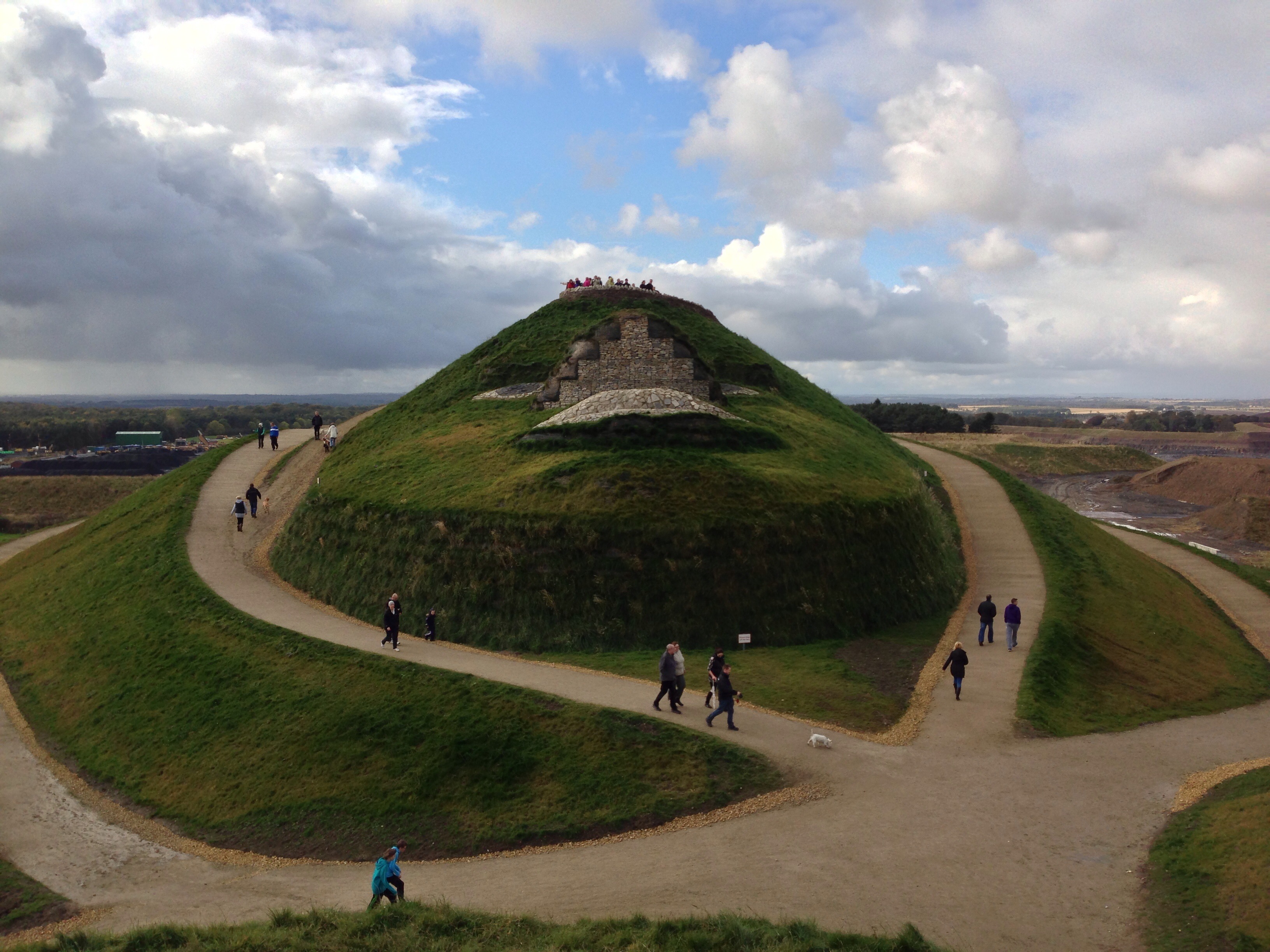
Northumberlandia

Northumberlandia (the "Lady of the North") is a huge land art sculpture in the shape of a reclining female figure, which was completed in 2012, near Cramlington...

Brenkley

Brenkley is a hamlet and former civil parish about 6 miles from Newcastle upon Tyne, now in the parish of Dinnington, in the Newcastle upon Tyne district...

St Mary's Hospital, Stannington

St Mary's Hospital was a mental health facility near Stannington, Northumberland, England. It was opened in 1910 and closed permanently in 1995. It was...

Nearby Amenities

Located within 500m of 55.099288,-1.6776811
Ewe Hill
Place: locality
Lat/Long: 55.0952891/-1.6808335
The data included in this document is from www.openstreetmap.org. The data is made available under ODbL.

Have you been to Victoria Plantation?

Leave your review of Victoria Plantation below (or comments, questions and feedback).