Alma Clump

Wood, Forest in Wiltshire

England

Alma Clump

Weather Hill, Wiltshire Summer wild flowers on Salisbury Plain in the vicinity of Weather Hill.
Weather Hill, Wiltshire Credit: Rebecca A Wills

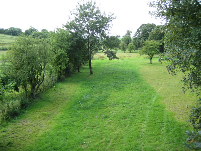
Alma Clump, located in Wiltshire, England, is a serene and picturesque woodland area that offers a tranquil escape for nature enthusiasts. Situated in close proximity to the village of Wood, Alma Clump is renowned for its stunning forest scenery and abundance of wildlife.

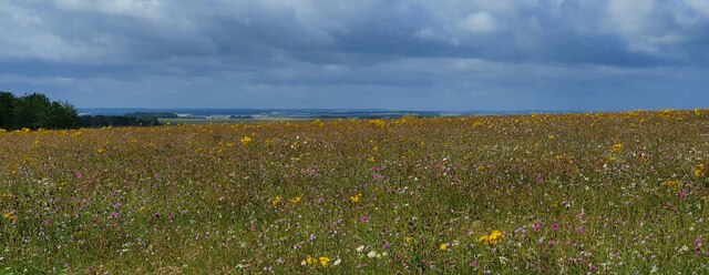
Covering an area of approximately 100 acres, Alma Clump is predominantly composed of ancient broadleaf woodland, with a diverse range of tree species including oak, ash, beech, and sycamore. These towering trees provide a dense canopy, casting dappled sunlight onto the forest floor and creating a magical atmosphere.

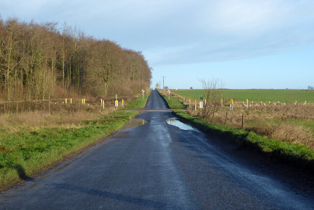
The woodland is crisscrossed by a network of well-maintained footpaths, making it easily accessible for visitors. These paths wind their way through the forest, offering walkers and hikers the opportunity to explore the area at their own pace. The tranquil ambiance of Alma Clump provides the perfect setting for a peaceful stroll, allowing visitors to immerse themselves in the beauty of nature.

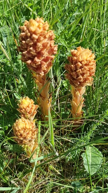
The forest is also home to a rich variety of wildlife, with deer, badgers, foxes, and numerous bird species frequently spotted by keen observers. The diverse ecosystem supports a range of flora and fauna, with wildflowers, fungi, and mosses adding vibrant splashes of color to the forest floor.

Alma Clump offers a haven for those seeking solace in nature, providing a peaceful retreat from the hustle and bustle of everyday life. Whether it be a leisurely walk, a birdwatching expedition, or simply a moment of tranquility, this enchanting woodland offers something for everyone to enjoy.

If you have any feedback on the listing, please let us know in the comments section below.

Alma Clump Images

Images are sourced within 2km of 51.278039/-1.7077554 or Grid Reference SU2053. Thanks to Geograph Open Source API. All images are credited.

Weather Hill, Wiltshire Summer wild flowers on Salisbury Plain in the vicinity of Weather Hill.
Weather Hill, Wiltshire
Summer wild flowers on Salisbury Plain in the vicinity of Weather Hill.
Weather Hill, Wiltshire Wild flowers on Salisbury Plain in the vicinity of Weather Hill.
Weather Hill, Wiltshire
Wild flowers on Salisbury Plain in the vicinity of Weather Hill.
Snail Down, Wiltshire Summer grassland and showers on Salisbury Plain!
Snail Down, Wiltshire
Summer grassland and showers on Salisbury Plain!
Snail Down, Wiltshire Looking west over Snail Down.
Snail Down, Wiltshire
Looking west over Snail Down.
Tank crossing on Marlborough Road The land to either side is a military training area.
Tank crossing on Marlborough Road
The land to either side is a military training area.
Weather Hill, Wiltshire A group of Knapweed Broomrapes. They are parasitic and also contain no chlorophyll, which explains the absence of green pigmentation. They are a relatively common sight on Salisbury Plain.
Weather Hill, Wiltshire
A group of Knapweed Broomrapes. They are parasitic and also contain no chlorophyll, which explains the absence of green pigmentation. They are a relatively common sight on Salisbury Plain.
Snail Down, Wiltshire A common sight at this time of year - the vibrant five spot burnet moth feeding on viper's bugloss.
Snail Down, Wiltshire
A common sight at this time of year - the vibrant five spot burnet moth feeding on viper's bugloss.
Downland, Collingbourne Ducis A more open landscape to the north associated with the Everleigh parachute drop-zone has given way to rougher grassland and scrubby woodland.
Downland, Collingbourne Ducis
A more open landscape to the north associated with the Everleigh parachute drop-zone has given way to rougher grassland and scrubby woodland.
Pasture, Everleigh Cattle grazing on farmed MOD land to the east of the village.
Pasture, Everleigh
Cattle grazing on farmed MOD land to the east of the village.
Houses, Everleigh The end of The Street in East Everleigh, the most concentrated area of housing in a scattered community.
Houses, Everleigh
The end of The Street in East Everleigh, the most concentrated area of housing in a scattered community.
Byway and farmland, Everleigh Like a lot of the MOD estate in this area, the land to the left is being farmed under the terms of an agricultural tenancy. That to the right is privately owned.
Byway and farmland, Everleigh
Like a lot of the MOD estate in this area, the land to the left is being farmed under the terms of an agricultural tenancy. That to the right is privately owned.
Farmland north of Everleigh View eastwards from near the entrance to Linden Farm Stores.

The mixture of cattle pasture and arable (oilseed rape and cereals) is typical of the area.
Farmland north of Everleigh
View eastwards from near the entrance to Linden Farm Stores. The mixture of cattle pasture and arable (oilseed rape and cereals) is typical of the area.
Snail Down Chalk downland within the MoD Salisbury Plain training area, south-east of Everleigh.

The wind sock has to do with an MoD parachute drop area, ahead and to the left.  To the right are some of the barrows seen in Vieve Forward's contribution: <a title="https://www.geograph.org.uk/photo/4454173" href="https://www.geograph.org.uk/photo/4454173">Link</a>
Snail Down
Chalk downland within the MoD Salisbury Plain training area, south-east of Everleigh. The wind sock has to do with an MoD parachute drop area, ahead and to the left. To the right are some of the barrows seen in Vieve Forward's contribution: Link
Byway to Pigleaze and Lower Everleigh Farmland on the left falls within the MoD's Salisbury Plain training area.
Byway to Pigleaze and Lower Everleigh
Farmland on the left falls within the MoD's Salisbury Plain training area.
Parachute drop over Salisbury Plain My location of this shot has to be a matter of guesswork, but - given the light south-easterly breeze - the C-130 must have been almost directly above the drop area at <a href="https://www.geograph.org.uk/photo/5387938">SU2152 : Snail Down</a>

<a href="https://www.geograph.org.uk/photo/5395192">SU2052 : C-130 over Salisbury Plain</a> gives a closer view of the aircraft (on an earlier run).
Parachute drop over Salisbury Plain
My location of this shot has to be a matter of guesswork, but - given the light south-easterly breeze - the C-130 must have been almost directly above the drop area at SU2152 : Snail Down SU2052 : C-130 over Salisbury Plain gives a closer view of the aircraft (on an earlier run).
C-130 over Salisbury Plain I had watched as this aircraft approached from the north-west, at a height of a few hundred feet and at low speed. Engine noise from the four turboprops was no more than a low-pitched hum - far quieter than from any commercial aircraft of similar size (or even from much smaller turboprop types).  In the photo, the trailing-edge flaps are down and the hold door/loading ramp is open.

A second or two after I'd taken the shot two cargo parachutes were discharged, opening almost immediately and disappearing behind trees.  By the time the C-130 re-appeared on the same flight-path some minutes later I had moved further off.  I was able to record the drop, but at a greater range: <a href="https://www.geograph.org.uk/photo/5394311">SU2152 : Parachute drop over Salisbury Plain</a>

Position is approximate, but based on the observation that the aircraft was only a couple of seconds short of the drop-zone on Snail Down.
C-130 over Salisbury Plain
I had watched as this aircraft approached from the north-west, at a height of a few hundred feet and at low speed. Engine noise from the four turboprops was no more than a low-pitched hum - far quieter than from any commercial aircraft of similar size (or even from much smaller turboprop types). In the photo, the trailing-edge flaps are down and the hold door/loading ramp is open. A second or two after I'd taken the shot two cargo parachutes were discharged, opening almost immediately and disappearing behind trees. By the time the C-130 re-appeared on the same flight-path some minutes later I had moved further off. I was able to record the drop, but at a greater range: SU2152 : Parachute drop over Salisbury Plain Position is approximate, but based on the observation that the aircraft was only a couple of seconds short of the drop-zone on Snail Down.
Six-spot burnet moth on viper's bugloss, Snail Down Photo taken within the MoD's Salisbury Plain Training Area, south of Everleigh.

On a warm day in June the chalk grassland on Snail Down seemed full of wildflowers.  A number of tall-growing species were conspicuous among the long grass - apart from Viper's Bugloss (Echium vulgare) we identified Weld, Wild Mignonette, Meadowsweet and Common Toadflax.  Six-spot burnet moths (Zygaena filipendulae) were present in abundance, and very active (the temperature being about 27C).  Viper's bugloss seemed to attract them in large numbers.
Six-spot burnet moth on viper's bugloss, Snail Down
Photo taken within the MoD's Salisbury Plain Training Area, south of Everleigh. On a warm day in June the chalk grassland on Snail Down seemed full of wildflowers. A number of tall-growing species were conspicuous among the long grass - apart from Viper's Bugloss (Echium vulgare) we identified Weld, Wild Mignonette, Meadowsweet and Common Toadflax. Six-spot burnet moths (Zygaena filipendulae) were present in abundance, and very active (the temperature being about 27C). Viper's bugloss seemed to attract them in large numbers.
Six-spot burnet moths gathering on viper's bugloss, Snail Down (1) The Six-spot Burnet Moth (Zygaena filipendulae) is a common species in chalk grassland, boldly marked and not easily overlooked.  I've often seen and photographed the species elsewhere <a title="https://www.geograph.org.uk/photo/4005636" href="https://www.geograph.org.uk/photo/4005636">Link</a>  <a title="https://www.geograph.org.uk/photo/5436543" href="https://www.geograph.org.uk/photo/5436543">Link</a>  but usually in ones and twos - never in the sort of numbers seen here.  Viper's bugloss was growing in some abundance among the long grass, and each plant was attracting burnet moths by the dozen.

At least two of the moths in the picture are in flight.  With the temperature at about 27C the moths were in constant (almost bee-like) motion.

Photograph taken within the MoD Salisbury Plain Training Area.
Six-spot burnet moths gathering on viper's bugloss, Snail Down (1)
The Six-spot Burnet Moth (Zygaena filipendulae) is a common species in chalk grassland, boldly marked and not easily overlooked. I've often seen and photographed the species elsewhere Link Link but usually in ones and twos - never in the sort of numbers seen here. Viper's bugloss was growing in some abundance among the long grass, and each plant was attracting burnet moths by the dozen. At least two of the moths in the picture are in flight. With the temperature at about 27C the moths were in constant (almost bee-like) motion. Photograph taken within the MoD Salisbury Plain Training Area.
Show me another place!

Alma Clump is located at Grid Ref: SU2053 (Lat: 51.278039, Lng: -1.7077554)

Unitary Authority: Wiltshire

Police Authority: Wiltshire

What 3 Words

///haystack.reminder.yoga. Near Collingbourne Kingston, Wiltshire

Related Wikis

Nearby Amenities

Located within 500m of 51.278039,-1.7077554
Everleigh
Place: village
Lat/Long: 51.2814473/-1.710541
Post Box
Brand: Royal Mail
Brand Wikidata: Q638098
Collection Times: Mo-Fr 09:00; Sa 07:00
Drive Through: no
Operator: Royal Mail
Operator Wikidata: Q638098
Post Box Type: lamp
Ref: SN8 150
Royal Cypher: EIIR
Royal Cypher Wikidata: Q33102113
Lat/Long: 51.2802278/-1.7120191
Defibrillator
Emergency: defibrillator
Lat/Long: 51.2812898/-1.7098023
Post Box
Brand: Royal Mail
Brand Wikidata: Q638098
Collection Times: Mo-Fr 09:00; Sa 07:00
Drive Through: no
Operator: Royal Mail
Operator Wikidata: Q638098
Post Box Type: lamp
Ref: SN8 69
Royal Cypher: EIIR
Royal Cypher Wikidata: Q33102113
Lat/Long: 51.2816749/-1.7061183
Barrier: stile
Lat/Long: 51.2801409/-1.7139276
Bus Stop
The Crown
Bus: yes
Naptan AtcoCode: 4600WIA13409
Naptan Bearing: E
Naptan BusStopType: CUS
Naptan CommonName: The Crown
Naptan Indicator: opp
Naptan NaptanCode: wildmadj
Naptan Street: A342
Naptan Verified: no
Public Transport: platform
Lat/Long: 51.2815108/-1.7090107
Bus Stop
The Crown
Bus: yes
Naptan AtcoCode: 4600WIA13408
Naptan Bearing: W
Naptan CommonName: The Crown
Naptan Indicator: o/s
Naptan NaptanCode: wildmadg
Naptan Street: A342
Naptan Verified: no
Public Transport: platform
Source: naptan;bing;naptan_compare_tool
Lat/Long: 51.2814133/-1.7091079
The data included in this document is from www.openstreetmap.org. The data is made available under ODbL.

Have you been to Alma Clump?

Leave your review of Alma Clump below (or comments, questions and feedback).