Bowmoor Plantation
Wood, Forest in Gloucestershire Cotswold
England
Bowmoor Plantation
Bowmoor Plantation is a picturesque woodland area located in Gloucestershire, England. Covering an expansive area of lush greenery and majestic trees, it is a haven for nature lovers and outdoor enthusiasts alike. Situated near the village of Wood, Bowmoor Plantation is well-known for its tranquil atmosphere and diverse range of flora and fauna.
The plantation boasts a rich history, dating back several centuries. Originally established as a hunting ground for local nobility, it gradually evolved into a thriving woodland ecosystem. Today, it is managed by a team of dedicated conservationists who strive to protect and enhance its natural beauty.
The woodland is predominantly composed of deciduous trees, including oak, beech, and birch, which provide a vibrant display of colors throughout the year. These trees, along with the dense undergrowth, offer a sanctuary to a wide variety of wildlife, including deer, foxes, and various bird species.
Bowmoor Plantation also features several well-maintained trails that wind through its enchanting landscape. These paths offer visitors the opportunity to explore the plantation’s beauty up close, whether it be by foot, bicycle, or horseback. The plantation is a popular destination for hikers and nature enthusiasts, who can enjoy the peaceful surroundings and immerse themselves in the wonders of the natural world.
In addition to its recreational offerings, Bowmoor Plantation plays a crucial role in the local ecosystem. It acts as a carbon sink, absorbing and storing significant amounts of carbon dioxide, thereby helping to combat climate change. The conservation efforts undertaken by the plantation’s management team also contribute to the preservation of rare and endangered species, promoting biodiversity in the region.
Overall, Bowmoor Plantation is a captivating destination, offering a perfect blend of natural beauty, recreational activities, and ecological significance.
If you have any feedback on the listing, please let us know in the comments section below.
Bowmoor Plantation Images
Images are sourced within 2km of 51.686361/-1.730002 or Grid Reference SU1898. Thanks to Geograph Open Source API. All images are credited.
![A figure of eight walk from Lechlade-on-Thames [7] The path now runs along the field edge.
After leaving Lechlade, the route joins the long distance Thames and Severn Way and passes the southern edge of Bowmoor Lake. Turning north, and looping around the northern edge of the lake, the Thames and Severn Way is re-joined and followed to the banks of the River Thames and back to Lechlade. Slightly over 5 miles.](https://s1.geograph.org.uk/geophotos/07/26/41/7264121_27a44cb8.jpg)
![A figure of eight walk from Lechlade-on-Thames [8] The path approaches the point where it joins the Thames and Severn Way.
After leaving Lechlade, the route joins the long distance Thames and Severn Way and passes the southern edge of Bowmoor Lake. Turning north, and looping around the northern edge of the lake, the Thames and Severn Way is re-joined and followed to the banks of the River Thames and back to Lechlade. Slightly over 5 miles.](https://s2.geograph.org.uk/geophotos/07/26/41/7264122_b7e2555a.jpg)
![A figure of eight walk from Lechlade-on-Thames [9] The path to Main Street leaves the track that is the Thames and Severn Way.
After leaving Lechlade, the route joins the long distance Thames and Severn Way and passes the southern edge of Bowmoor Lake. Turning north, and looping around the northern edge of the lake, the Thames and Severn Way is re-joined and followed to the banks of the River Thames and back to Lechlade. Slightly over 5 miles.](https://s3.geograph.org.uk/geophotos/07/26/41/7264123_4324e15f.jpg)
![A figure of eight walk from Lechlade-on-Thames [43] Now beyond the southern edge of the lake, the track continues with access to a property on the right.
After leaving Lechlade, the route joins the long distance Thames and Severn Way and passes the southern edge of Bowmoor Lake. Turning north, and looping around the northern edge of the lake, the Thames and Severn Way is re-joined and followed to the banks of the River Thames and back to Lechlade. Slightly over 5 miles.](https://s1.geograph.org.uk/geophotos/07/26/52/7265265_1600e270.jpg)
![A figure of eight walk from Lechlade-on-Thames [44] A property on the south side of the track.
After leaving Lechlade, the route joins the long distance Thames and Severn Way and passes the southern edge of Bowmoor Lake. Turning north, and looping around the northern edge of the lake, the Thames and Severn Way is re-joined and followed to the banks of the River Thames and back to Lechlade. Slightly over 5 miles.](https://s3.geograph.org.uk/geophotos/07/26/52/7265267_35ae6a48.jpg)
![A figure of eight walk from Lechlade-on-Thames [45] Looking back along the road.
After leaving Lechlade, the route joins the long distance Thames and Severn Way and passes the southern edge of Bowmoor Lake. Turning north, and looping around the northern edge of the lake, the Thames and Severn Way is re-joined and followed to the banks of the River Thames and back to Lechlade. Slightly over 5 miles.](https://s2.geograph.org.uk/geophotos/07/26/60/7266014_7ccd338b.jpg)
![A figure of eight walk from Lechlade-on-Thames [46] At this junction of paths, the route now heads south towards the confluence of the River Coln with the River Thames.
After leaving Lechlade, the route joins the long distance Thames and Severn Way and passes the southern edge of Bowmoor Lake. Turning north, and looping around the northern edge of the lake, the Thames and Severn Way is re-joined and followed to the banks of the River Thames and back to Lechlade. Slightly over 5 miles.](https://s3.geograph.org.uk/geophotos/07/26/60/7266015_db91a609.jpg)
![A figure of eight walk from Lechlade-on-Thames [47] The track gives access to leads to The Round House.
After leaving Lechlade, the route joins the long distance Thames and Severn Way and passes the southern edge of Bowmoor Lake. Turning north, and looping around the northern edge of the lake, the Thames and Severn Way is re-joined and followed to the banks of the River Thames and back to Lechlade. Slightly over 5 miles.](https://s0.geograph.org.uk/geophotos/07/26/60/7266016_33728d6f.jpg)
![A figure of eight walk from Lechlade-on-Thames [48] The public footpath veers to the left, the track continues to The Round House.
After leaving Lechlade, the route joins the long distance Thames and Severn Way and passes the southern edge of Bowmoor Lake. Turning north, and looping around the northern edge of the lake, the Thames and Severn Way is re-joined and followed to the banks of the River Thames and back to Lechlade. Slightly over 5 miles.](https://s1.geograph.org.uk/geophotos/07/26/60/7266017_e2af831d.jpg)
![A figure of eight walk from Lechlade-on-Thames [49] This bridge carries the track to The Round House over the River Coln.
Here the River Coln and the River Thames have their confluence and, between the rivers, the now disused Thames and Severn Canal comes to an end as it meets the river.
After leaving Lechlade, the route joins the long distance Thames and Severn Way and passes the southern edge of Bowmoor Lake. Turning north, and looping around the northern edge of the lake, the Thames and Severn Way is re-joined and followed to the banks of the River Thames and back to Lechlade. Slightly over 5 miles.](https://s2.geograph.org.uk/geophotos/07/26/60/7266018_b8ba8707.jpg)
![A figure of eight walk from Lechlade-on-Thames [50] This footbridge carries the long distance Thames and Severn Way over the River Thames. Here the River Coln and the River Thames have their confluence and, between the rivers, the now disused Thames and Severn Canal comes to an end as it joins the river.
After leaving Lechlade, the route joins the long distance Thames and Severn Way and passes the southern edge of Bowmoor Lake. Turning north, and looping around the northern edge of the lake, the Thames and Severn Way is re-joined and followed to the banks of the River Thames and back to Lechlade. Slightly over 5 miles.](https://s3.geograph.org.uk/geophotos/07/26/60/7266019_f4c5d9d6.jpg)
![A figure of eight walk from Lechlade-on-Thames [51] The Round House is set alongside the now disused Thames and Severn Canal where it comes to an end as it joins the River Thames. Seen from the path that is now both the Thames and Severn Way and The Thames Path. The Round House and the Round House Cottage are both listed, grade II, with details for The Round House at: <span class="nowrap"><a title="https://historicengland.org.uk/listing/the-list/list-entry/1089423" rel="nofollow ugc noopener" href="https://historicengland.org.uk/listing/the-list/list-entry/1089423">Link</a><img style="margin-left:2px;" alt="External link" title="External link - shift click to open in new window" src="https://s1.geograph.org.uk/img/external.png" width="10" height="10"/></span> and for Round House Cottage at: <span class="nowrap"><a title="https://historicengland.org.uk/listing/the-list/list-entry/1089424" rel="nofollow ugc noopener" href="https://historicengland.org.uk/listing/the-list/list-entry/1089424">Link</a><img style="margin-left:2px;" alt="External link" title="External link - shift click to open in new window" src="https://s1.geograph.org.uk/img/external.png" width="10" height="10"/></span>
After leaving Lechlade, the route joins the long distance Thames and Severn Way and passes the southern edge of Bowmoor Lake. Turning north, and looping around the northern edge of the lake, the Thames and Severn Way is re-joined and followed to the banks of the River Thames and back to Lechlade. Slightly over 5 miles.](https://s0.geograph.org.uk/geophotos/07/26/60/7266020_4f023a98.jpg)
![A figure of eight walk from Lechlade-on-Thames [52] The path, both the Thames and Severn Way and The Thames Path, runs alongside the River Thames towards Lechlade.
After leaving Lechlade, the route joins the long distance Thames and Severn Way and passes the southern edge of Bowmoor Lake. Turning north, and looping around the northern edge of the lake, the Thames and Severn Way is re-joined and followed to the banks of the River Thames and back to Lechlade. Slightly over 5 miles.](https://s1.geograph.org.uk/geophotos/07/26/60/7266021_c8c87121.jpg)
![A figure of eight walk from Lechlade-on-Thames [54] A view across the fields to The Round House. There is a closer view of the Round House at <a href="https://www.geograph.org.uk/photo/7266020">SU2098 : A figure of eight walk from Lechlade-on-Thames [51]</a>.
After leaving Lechlade, the route joins the long distance Thames and Severn Way and passes the southern edge of Bowmoor Lake. Turning north, and looping around the northern edge of the lake, the Thames and Severn Way is re-joined and followed to the banks of the River Thames and back to Lechlade. Slightly over 5 miles.](https://s0.geograph.org.uk/geophotos/07/26/60/7266024_c50a8b90.jpg)


Bowmoor Plantation is located at Grid Ref: SU1898 (Lat: 51.686361, Lng: -1.730002)
Administrative County: Gloucestershire
District: Cotswold
Police Authority: Gloucestershire
What 3 Words
///consumed.work.firelight. Near Lechlade, Gloucestershire
Nearby Locations
Related Wikis
River Coln
The River Coln is a river in Gloucestershire, England. It rises to the north of Brockhampton, a village to the east of Cheltenham, and flows in a south/south...
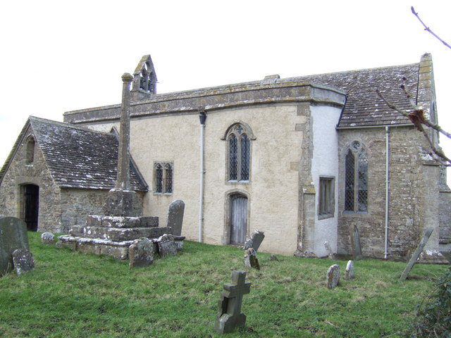
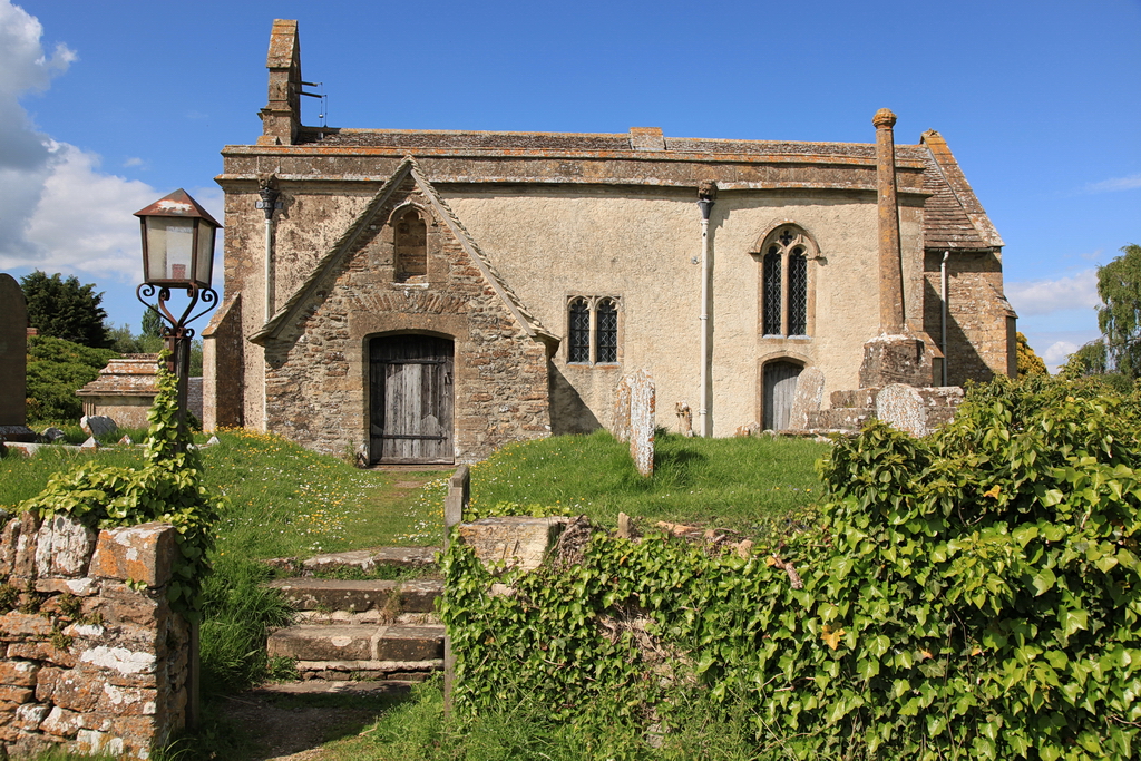
St John the Baptist Church, Inglesham
St John the Baptist Church in Inglesham, near Swindon, Wiltshire, England, has Anglo-Saxon origins but most of the current structure was built around 1205...
Inglesham
Inglesham is a small village and civil parish in the Borough of Swindon, Wiltshire, England, notable for the Grade-I listed St John the Baptist Church...
Whelford
Whelford is a village in the civil parish of Kempsford, in the Cotswold district, in the county of Gloucestershire, England. Whelford lies in the Cotswold...

Whelford Meadow
Whelford Meadow (grid reference SP168000) is a 1.86-hectare (4.6-acre) biological Site of Special Scientific Interest in Gloucestershire, England, notified...

Thames meander
Thames meander refers to a long-distance journey over all or part of the River Thames in England. Walking the Thames Path is itself a meander, but the...

Halfpenny Bridge
Halfpenny Bridge is a bridge across the River Thames, at Lechlade, Gloucestershire, England. The bridge and its toll house are a Grade II listed building...

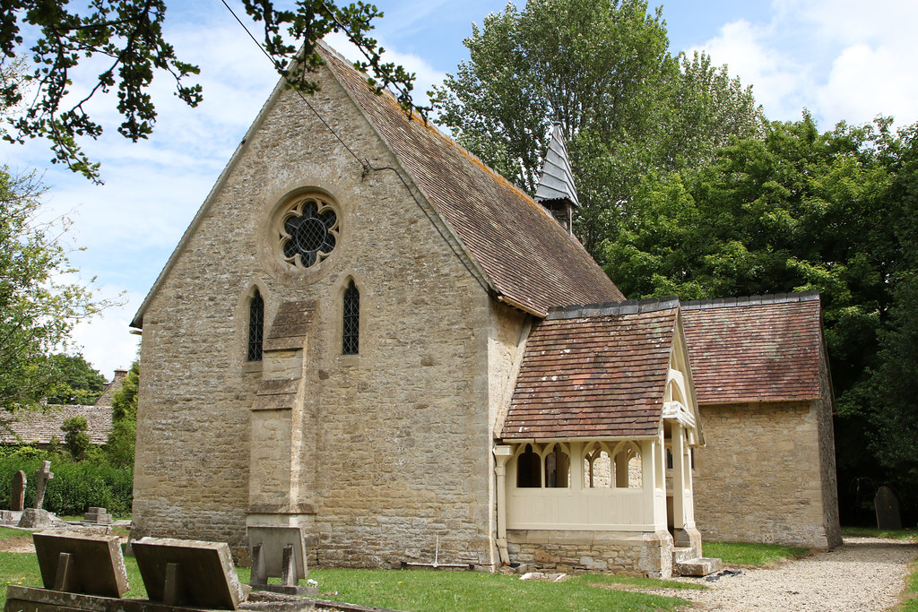
St Lawrence Church, Lechlade
The Anglican St Lawrence Church, dedicated to St. Lawrence of Rome, is the Church of England parish church of Lechlade in Gloucestershire, England. The...
Nearby Amenities
Located within 500m of 51.686361,-1.730002Have you been to Bowmoor Plantation?
Leave your review of Bowmoor Plantation below (or comments, questions and feedback).