Barber's Coppice

Wood, Forest in Warwickshire

England

Barber's Coppice

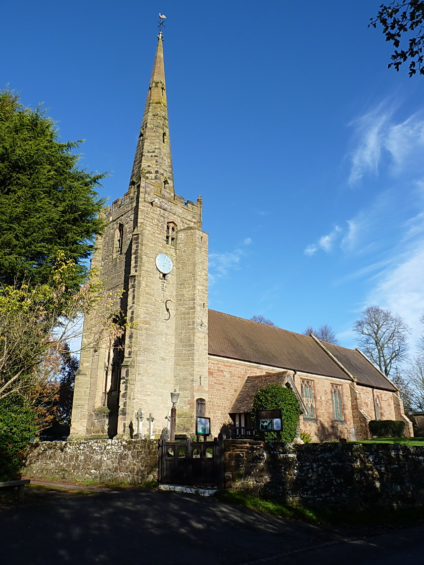
St Mary & St Bartholomew, Hampton-in-Arden The Parish Church of St Mary & St Bartholomew, Hampton-in-Arden.
St Mary & St Bartholomew, Hampton-in-Arden Credit: Julian Dowse

Barber's Coppice is a picturesque woodland located in Warwickshire, England. Spanning over an area of approximately 50 acres, this enchanting forest is nestled near the village of Henley-in-Arden. The woodland is named after the Barber family, who were the former owners of the land.

The coppice is predominantly made up of native tree species, including oak, ash, beech, and birch, which create a diverse and vibrant ecosystem. The tall, majestic trees provide a dense canopy, allowing only dappled sunlight to filter through to the forest floor. This creates a tranquil and peaceful atmosphere, making Barber's Coppice a popular destination for nature enthusiasts and walkers seeking a serene escape.

Wildlife thrives within the woodland, with a variety of bird species, such as woodpeckers and owls, making their homes among the trees. The forest floor is rich in plant life, with wildflowers, ferns, and mosses adding to the natural beauty of the area.

The woodland is crisscrossed by a network of well-maintained footpaths, allowing visitors to explore its hidden treasures. These paths wind through the forest, leading to open glades, babbling brooks, and secluded ponds. The peaceful ambiance of Barber's Coppice makes it a perfect spot for picnics or simply enjoying the tranquility of nature.

Managed by the local council, Barber's Coppice is protected to preserve its unique ecosystem. Regular maintenance ensures the health and vitality of the woodland, while also providing a safe environment for visitors.

In conclusion, Barber's Coppice in Warwickshire is a stunning woodland, offering a peaceful retreat and a chance to connect with nature. With its diverse flora and fauna, it is a haven for wildlife and a delight for those who appreciate the beauty of the natural world.

If you have any feedback on the listing, please let us know in the comments section below.

Barber's Coppice Images

Images are sourced within 2km of 52.424156/-1.7324482 or Grid Reference SP1880. Thanks to Geograph Open Source API. All images are credited.

St Mary & St Bartholomew, Hampton-in-Arden The Parish Church of St Mary & St Bartholomew, Hampton-in-Arden.
St Mary & St Bartholomew, Hampton-in-Arden
The Parish Church of St Mary & St Bartholomew, Hampton-in-Arden.
St Mary & St Bartholomew, Hampton-in-Arden St Mary & St Bartholomew, Hampton-in-Arden
The Parish Church of St Mary & St Bartholomew, Hampton-in-Arden.
St Mary & St Bartholomew, Hampton-in-Arden
St Mary & St Bartholomew, Hampton-in-Arden The Parish Church of St Mary & St Bartholomew, Hampton-in-Arden.
Hampton in Arden from the air The Parish Church of Saint Mary and Saint Bartholomew can be seen near the centre of the photo. Viewed on approach to Birmingham from a flight from Prague.
Hampton in Arden from the air
The Parish Church of Saint Mary and Saint Bartholomew can be seen near the centre of the photo. Viewed on approach to Birmingham from a flight from Prague.
Hampton in Arden from the air The railway line which bisects the village can be seen on the right. Viewed on approach to Birmingham from a flight from Prague.
Hampton in Arden from the air
The railway line which bisects the village can be seen on the right. Viewed on approach to Birmingham from a flight from Prague.
Hampton maize A healthy looking crop of maize at Hampton in Arden, West Midlands.
Hampton maize
A healthy looking crop of maize at Hampton in Arden, West Midlands.
Hampton-in-Arden manor The Manor House in this Warwickshire village.
Hampton-in-Arden manor
The Manor House in this Warwickshire village.
Church Steps The steps to St Mary and St Bartholomew the Parish Church of Hampton in Arden from the Solihull Road.
Church Steps
The steps to St Mary and St Bartholomew the Parish Church of Hampton in Arden from the Solihull Road.
Hampton Church St Mary and St Bartholomew the Parish Church of Hampton in Arden on the High Street. The Chancel dates back to 1130.
Hampton Church
St Mary and St Bartholomew the Parish Church of Hampton in Arden on the High Street. The Chancel dates back to 1130.
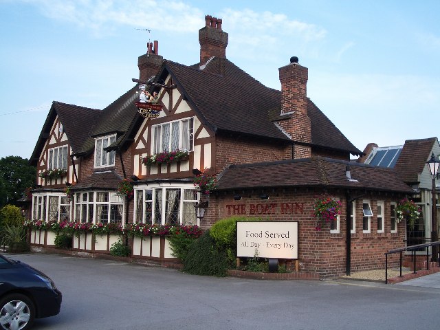
The Boat Inn The Boat Inn is situated in the village of Catherine De Barnes which was once a small area of heath within Longdon Manor. The village takes its name  from the 12th century Lord of the Manor whose name was KETELBERNE.
The Boat Inn
The Boat Inn is situated in the village of Catherine De Barnes which was once a small area of heath within Longdon Manor. The village takes its name from the 12th century Lord of the Manor whose name was KETELBERNE.
Early Morning Traffic on the M42 Motorway The busy morning traffic is moving for a change (!!!) following the implementation in November 2005 of the new "Active Traffic Management" system on this stretch of the M42 costing approx £100 million, similar to that already in use on the M25 motorway
Early Morning Traffic on the M42 Motorway
The busy morning traffic is moving for a change (!!!) following the implementation in November 2005 of the new "Active Traffic Management" system on this stretch of the M42 costing approx £100 million, similar to that already in use on the M25 motorway
Parish Church of Saint Peter, Bickenhill in the Birmingham Diocese This beautiful old parish church lies in the tiny village of Bickenhill.  Unfortunately it is located very close to Birmingham International Airport and is threatened by the potential future airport expansion plans.
Parish Church of Saint Peter, Bickenhill in the Birmingham Diocese
This beautiful old parish church lies in the tiny village of Bickenhill. Unfortunately it is located very close to Birmingham International Airport and is threatened by the potential future airport expansion plans.
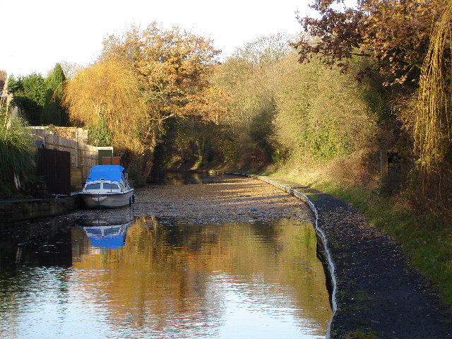
Grand Union Canal just beyond Catherine de Barnes village The picture is taken from the towpath of the canal under the road bridge, just beyond the Boat Inn public house
Grand Union Canal just beyond Catherine de Barnes village
The picture is taken from the towpath of the canal under the road bridge, just beyond the Boat Inn public house
Village shops in Catherine de Barnes The local shops are directly opposite the Boat Inn located on the B4102 from Solihull to Hampton in Arden
Village shops in Catherine de Barnes
The local shops are directly opposite the Boat Inn located on the B4102 from Solihull to Hampton in Arden
The Grand Union Canal, Solihull
Sports Ground, Old Damson Lane, Elmdon This is the entrance (off the lane) to the Birmingham CSSC Sports Ground.
Sports Ground, Old Damson Lane, Elmdon
This is the entrance (off the lane) to the Birmingham CSSC Sports Ground.
Woodhouse Farm, Catherine de Barnes In spite of being close to the Birmingham conurbation and the M42, this is a very sparsely populated square.
Woodhouse Farm, Catherine de Barnes
In spite of being close to the Birmingham conurbation and the M42, this is a very sparsely populated square.
Shadowbrook Lane This is the junction of Shadowbrook Lane and Catherine de Barnes Lane. Shadowbrook Lane leads to Hampton in Arden.
Shadowbrook Lane
This is the junction of Shadowbrook Lane and Catherine de Barnes Lane. Shadowbrook Lane leads to Hampton in Arden.
An Air Quality Monitoring Station above the M42 This Air Quality Monitoring Station is in Shadowbrook Lane, on a bridge above the M42.
An Air Quality Monitoring Station above the M42
This Air Quality Monitoring Station is in Shadowbrook Lane, on a bridge above the M42.
Show me another place!

Barber's Coppice is located at Grid Ref: SP1880 (Lat: 52.424156, Lng: -1.7324482)

Unitary Authority: Solihull

Police Authority: West Midlands

What 3 Words

///jars.grapes.fries. Near Bickenhill, West Midlands

Nearby Locations

Barber's Coppice

Related Wikis

Catherine-de-Barnes

Catherine-de-Barnes (known to locals as Catney) is a small village within the Metropolitan Borough of Solihull in the English county of West Midlands....

Páirc na hÉireann

Páirc na hÉireann, near Bickenhill, Solihull, England, is the principal Gaelic games sports facility in the West Midlands. It is administered by the Warwickshire...

Catherine-de-Barnes Isolation Hospital

Catherine-de-Barnes Isolation Hospital was a specialist isolation hospital for infection control in Catherine-de-Barnes, a village within the Metropolitan...

Blackwood F.C.

Blackwood F.C. was a football club based in Solihull, West Midlands.. == History == Blackwood Football Club was formed in 1964 and played Sunday league...

Bickenhill Meadows

Bickenhill Meadows is a 7.2 hectares (18 acres) biological site of Special Scientific Interest in the West Midlands. The site was notified in 1991 under...

Berry Hall Farm

Berry Hall Farm is a moated, fifteenth century half-timbered property located on Ravenshaw Lane in central Solihull. Originally named 'Berry Hall' and...

Bickenhill

Bickenhill is a village in the civil parish of Bickenhill and Marston Green, in the Metropolitan Borough of Solihull, in the West Midlands county, England...

Peel's Restaurant

Peel's Restaurant is situated in Hampton Manor, Hampton-in-Arden. It currently holds one Michelin star and four AA Rosettes. Hampton Manor is a Grade II...

Nearby Amenities

Located within 500m of 52.424156,-1.7324482
Catherine-de-Barnes
Place: hamlet
Wikidata: Q5052511
Wikipedia: en:Catherine-de-Barnes
Lat/Long: 52.4223526/-1.7381485
Turning Circle
Source: bing
Lat/Long: 52.421281/-1.7376619
Power: tower
Source: Bing
Lat/Long: 52.4235204/-1.7258091
Power: tower
Source: Bing
Lat/Long: 52.4213488/-1.7280294
Operator: Esso
Pipeline: marker
Substance: oil
Lat/Long: 52.4224683/-1.7301459
Location: underground
Operator: Esso
Pipeline: marker
Ref: Km 34.66
Substance: oil
Lat/Long: 52.427533/-1.7311926
Location: underground
Operator: Esso
Pipeline: marker
Ref: Km 34.64
Substance: oil
Lat/Long: 52.4274037/-1.7311094
Location: underground
Operator: Esso
Pipeline: marker
Ref: Km 34.05
Source: survey
Substance: oil
Lat/Long: 52.4225896/-1.7301349
Pipeline: marker
Source: visual survey;estimate
Substance: gas
Lat/Long: 52.4209608/-1.7326702
Power: tower
Source: bing
Lat/Long: 52.4217649/-1.728116
Power: tower
Source: bing
Lat/Long: 52.4230883/-1.7257808
Post Box
Collection Times: Mo-Fr 16:00; Sa 12:00
Operator: Royal Mail
Post Box Type: pillar
Ref: B91 428
Royal Cypher: EIIR
Royal Cypher Wikidata: Q33102113
Source: survey
Lat/Long: 52.4210277/-1.7373789
Give Way
Source: Warwicks CC Aerial Imagery 2013
Lat/Long: 52.4221791/-1.7342774
Stop
Source: Warwicks CC Aerial Imagery 2013
Lat/Long: 52.4215779/-1.7361094
Power: pole
Ref: 722255
Source: wpd_open_data
Transformer: distribution
Lat/Long: 52.4215383/-1.7346583
Power: pole
Source: Warwicks CC Aerial Imagery 2013
Lat/Long: 52.4212732/-1.7293274
Power: pole
Source: Warwicks CC Aerial Imagery 2013
Lat/Long: 52.4213191/-1.7306645
Power: pole
Source: Warwicks CC Aerial Imagery 2013
Lat/Long: 52.4213959/-1.7319909
Power: pole
Source: Warwicks CC Aerial Imagery 2013
Lat/Long: 52.4214426/-1.7329015
Power: pole
Ref: 722253
Source: wpd_open_data
Transformer: distribution
Lat/Long: 52.4211947/-1.7278455
Barrier: yes
Lat/Long: 52.4205685/-1.7353326
The data included in this document is from www.openstreetmap.org. The data is made available under ODbL.

Have you been to Barber's Coppice?

Leave your review of Barber's Coppice below (or comments, questions and feedback).