Athy's Dean

Wood, Forest in Northumberland

England

Athy's Dean

Fields near Tranwell Farm
Fields near Tranwell Farm Credit: David Dixon

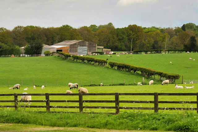
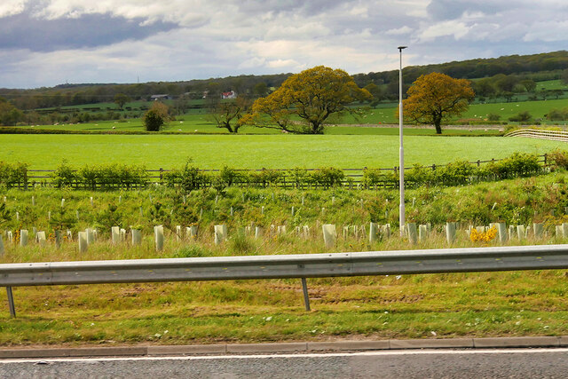
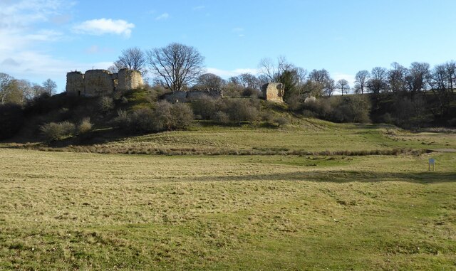
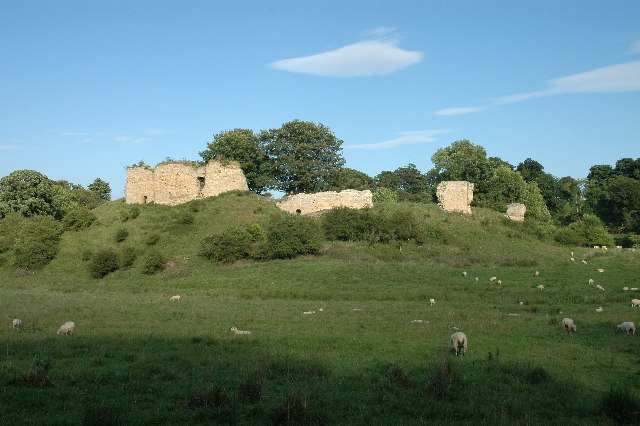
Athy's Dean, located in Northumberland, England, is a picturesque woodland area known for its natural beauty and rich history. Covering an estimated area of 1,200 acres, this ancient forest is nestled within the stunning countryside, making it a popular destination for nature enthusiasts and history buffs alike.

The woodland is named after the nearby village of Athy, and it has been well-preserved throughout the centuries. The forest is home to a diverse range of flora and fauna, including oak, birch, and beech trees that create a dense canopy, providing a habitat for various bird species, such as woodpeckers, owls, and songbirds. The forest floor is also teeming with a vibrant array of wildflowers and ferns, adding to the area's natural charm.

Athy's Dean has a long and intriguing history dating back to medieval times. It is believed that the forest was once used as a hunting ground by local nobility, and remnants of ancient deer parks can still be found within the woods. Additionally, the forest has played a significant role in the region's coal mining history, with evidence of old mine entrances and disused railway lines scattered throughout the area.

Visitors to Athy's Dean can explore the forest through a network of well-maintained walking trails, allowing them to fully immerse themselves in the serene and tranquil surroundings. The woodland also offers opportunities for wildlife spotting, birdwatching, and photography, making it a haven for nature lovers seeking solace in the great outdoors.

In conclusion, Athy's Dean in Northumberland is a captivating woodland area that seamlessly combines natural beauty with a rich historical heritage. Whether it's a leisurely stroll among the trees or an exploration of its fascinating past, this forest offers a truly enchanting experience for all who visit.

If you have any feedback on the listing, please let us know in the comments section below.

Athy's Dean Images

Images are sourced within 2km of 55.161537/-1.7150527 or Grid Reference NZ1885. Thanks to Geograph Open Source API. All images are credited.

Fields near Tranwell Farm
Farmland, High Church
Saplings at St Leonard's Junction Newly planted saplings alongside the A1 at St Leonard's Junction (A1/A197 Morpeth Bypass).
Saplings at St Leonard's Junction
Newly planted saplings alongside the A1 at St Leonard's Junction (A1/A197 Morpeth Bypass).
Hiding in plain sight The sundial on the south wall of the Church of St. Mary the Virgin is a large one but is easily missed.  See also <a href="https://www.geograph.org.uk/photo/7004976">NZ1985 : Sundial on the Church of St. Mary the Virgin</a>
Hiding in plain sight
The sundial on the south wall of the Church of St. Mary the Virgin is a large one but is easily missed. See also NZ1985 : Sundial on the Church of St. Mary the Virgin
Sundial on the Church of St. Mary the Virgin This elegant sundial is carved into the stonework, high on the south side of the chancel wall.  The long slender gnomon provides high precision.  Not sure what the 'T W' stands for, or the lower 'j W'. See also <a href="https://www.geograph.org.uk/photo/7004966">NZ1985 : Hiding in plain sight</a>
Sundial on the Church of St. Mary the Virgin
This elegant sundial is carved into the stonework, high on the south side of the chancel wall. The long slender gnomon provides high precision. Not sure what the 'T W' stands for, or the lower 'j W'. See also NZ1985 : Hiding in plain sight
Old signpost beside the old A1 Such precision! The base bearing the letters and numbers is quite badly cracked but still legible.  See <a href="https://www.geograph.org.uk/photo/7004999">NZ1985 : Old signpost beside the old A1</a> for the reverse side.
Old signpost beside the old A1
Such precision! The base bearing the letters and numbers is quite badly cracked but still legible. See NZ1985 : Old signpost beside the old A1 for the reverse side.
Old signpost beside the old A1 The reverse side of <a href="https://www.geograph.org.uk/photo/7004991">NZ1985 : Old signpost beside the old A1</a>  Looking quite well maintained, see <a href="https://www.geograph.org.uk/photo/6048069">NZ1985 : Old Sign board by the B1337 in Morpeth</a>
Old signpost beside the old A1
The reverse side of NZ1985 : Old signpost beside the old A1 Looking quite well maintained, see NZ1985 : Old Sign board by the B1337 in Morpeth
Giant 'comb' in action Collecting logs and debris in the aftermath of Storm Arwen this structure on the Wansbeck, designed to protect Morpeth bridges etc., appears to be doing its job effectively.
Giant 'comb' in action
Collecting logs and debris in the aftermath of Storm Arwen this structure on the Wansbeck, designed to protect Morpeth bridges etc., appears to be doing its job effectively.
Gate House to Mitford Hall
Mitford Cricket Ground
Mitford Castle The Norman motte and bailey castle stands on a small prominence, a somewhat elliptical mound, above the River Wansbeck. The selected building site allowed for the natural hill to be scarped and ditched, producing the motte. Wikipedia.
Mitford Castle
The Norman motte and bailey castle stands on a small prominence, a somewhat elliptical mound, above the River Wansbeck. The selected building site allowed for the natural hill to be scarped and ditched, producing the motte. Wikipedia.
Lych Gate of the Church of St. Mary Magdalene, Mitford  The parish church of Mitford, although locally prominent in the landscape through its lofty spire, lies low on the south bank of the Wansbeck, and is overlooked on the south east by the prominent knoll that carries the ruins of Mitford
Castle.
Lych Gate of the Church of St. Mary Magdalene, Mitford
The parish church of Mitford, although locally prominent in the landscape through its lofty spire, lies low on the south bank of the Wansbeck, and is overlooked on the south east by the prominent knoll that carries the ruins of Mitford Castle.
Direction Sign – Signpost on St Leonards Lane, Mitford Located on the northeast side of the junction of the B6343 and St Leonards Lane in Mitford parish. 1 arm and fan finial. See also <a title="https://www.geograph.org.uk/photo/6527519" href="https://www.geograph.org.uk/photo/6527519">Link</a> and <a title="https://www.geograph.org.uk/photo/1767673" href="https://www.geograph.org.uk/photo/1767673">Link</a>.

Milestone Society National ID: NB_NZ1785
Direction Sign – Signpost on St Leonards Lane, Mitford
Located on the northeast side of the junction of the B6343 and St Leonards Lane in Mitford parish. 1 arm and fan finial. See also Link and Link. Milestone Society National ID: NB_NZ1785
River Wansbeck at Highford Bridge
Show me another place!

Athy's Dean is located at Grid Ref: NZ1885 (Lat: 55.161537, Lng: -1.7150527)

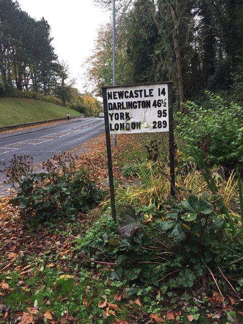
Unitary Authority: Northumberland

Police Authority: Northumbria

What 3 Words

///hope.escalates.prospers. Near Morpeth, Northumberland

Related Wikis

Morpeth Town A.F.C.

Morpeth Town Association Football Club is a football club based in Morpeth, Northumberland, England. They are currently members of the Northern Premier...

Newminster Abbey

Newminster Abbey was a Cistercian abbey in Northumberland in the north of England. The site is protected by Grade II listed building and Scheduled Ancient...

Mitford, Northumberland

Mitford is a village in Northumberland, England, located 2 miles (3 km) west of Morpeth. == History == Although the foundation of Mitford is unknown, it...
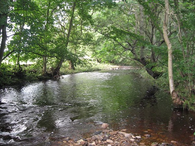
River Font

The River Font is a river that flows through Northumberland, England. The river is a tributary of the River Wansbeck which it joins at Mitford. == References... ==

Mitford Castle

Mitford Castle is an English castle dating from the end of the 11th century and located at Mitford, Northumberland. It is a Scheduled Ancient Monument...

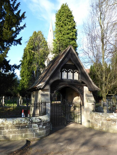
St Mary's, High Church

St Mary's, also known as St Mary the Virgin, is an ancient Grade I listed Church of England parish church located in Morpeth, Northumberland. The church...

Mitford Old Manor House

Mitford Old Manor House is an historic English manor house at Mitford, Northumberland, and is a Grade II* listed building. The Manor of Mitford was held...

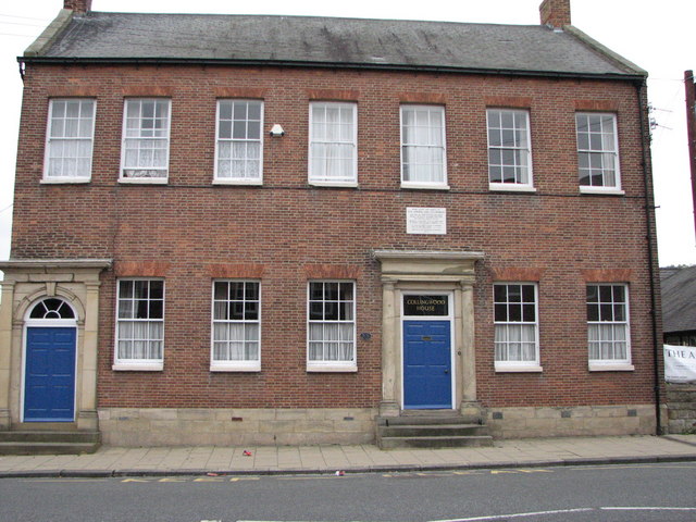
Collingwood House, Morpeth

Collingwood House is a late 18th-century Georgian house, having Grade II* listed building status, at Oldgate, Morpeth, Northumberland. It was the home...

Nearby Amenities

Located within 500m of 55.161537,-1.7150527
Noexit: yes
Lat/Long: 55.1635284/-1.708777
Noexit: yes
Lat/Long: 55.160502/-1.7095263
Noexit: yes
Lat/Long: 55.1610397/-1.7093024
Power: pole
Source: Bing
Lat/Long: 55.1576305/-1.7133376
Power: pole
Source: Bing
Lat/Long: 55.1581969/-1.7131349
Power: pole
Source: Bing
Lat/Long: 55.1587619/-1.7129229
Athey's Dean
Natural: wood
Lat/Long: 55.1622686/-1.7141651
Borough Wood
Place: locality
Lat/Long: 55.1646097/-1.7166756
Post Box
Collection Times: Mo-Fr 17:15; Sa 12:15
Post Box Type: pillar
Ref: NE61 157
Royal Cypher: EIIR
Royal Cypher Wikidata: Q33102113
Source: survey
Lat/Long: 55.1616003/-1.7079328
Noexit: yes
Lat/Long: 55.1640106/-1.7087934
Generator Method: photovoltaic
Generator Output Electricity: yes
Generator Source: solar
Generator Type: solar_photovoltaic_panel
Location: roof
Power: generator
Lat/Long: 55.160279/-1.7095442
Generator Method: photovoltaic
Generator Output Electricity: yes
Generator Source: solar
Generator Type: solar_photovoltaic_panel
Location: roof
Power: generator
Lat/Long: 55.1605782/-1.7089567
Generator Method: photovoltaic
Generator Output Electricity: yes
Generator Source: solar
Generator Type: solar_photovoltaic_panel
Location: roof
Power: generator
Lat/Long: 55.1611715/-1.7101661
Generator Method: photovoltaic
Generator Output Electricity: yes
Generator Source: solar
Generator Type: solar_photovoltaic_panel
Location: roof
Power: generator
Lat/Long: 55.1611815/-1.709886
Generator Method: photovoltaic
Generator Output Electricity: yes
Generator Source: solar
Generator Type: solar_photovoltaic_panel
Location: roof
Power: generator
Lat/Long: 55.1614378/-1.7098257
Generator Method: photovoltaic
Generator Output Electricity: yes
Generator Source: solar
Generator Type: solar_photovoltaic_panel
Location: roof
Power: generator
Lat/Long: 55.1621749/-1.7083693
Generator Method: photovoltaic
Generator Output Electricity: yes
Generator Source: solar
Generator Type: solar_photovoltaic_panel
Location: roof
Power: generator
Lat/Long: 55.1621749/-1.7084229
Generator Method: photovoltaic
Generator Output Electricity: yes
Generator Source: solar
Generator Type: solar_photovoltaic_panel
Location: roof
Power: generator
Lat/Long: 55.1622055/-1.7080635
Generator Method: photovoltaic
Generator Output Electricity: yes
Generator Source: solar
Generator Type: solar_photovoltaic_panel
Location: roof
Power: generator
Lat/Long: 55.1622086/-1.7080233
Generator Method: photovoltaic
Generator Output Electricity: yes
Generator Source: solar
Generator Type: solar_photovoltaic_panel
Location: roof
Power: generator
Lat/Long: 55.161755/-1.7097238
Generator Method: photovoltaic
Generator Output Electricity: yes
Generator Source: solar
Generator Type: solar_photovoltaic_panel
Location: roof
Power: generator
Lat/Long: 55.1623924/-1.7097238
Generator Method: photovoltaic
Generator Output Electricity: yes
Generator Source: solar
Generator Type: solar_photovoltaic_panel
Location: roof
Power: generator
Lat/Long: 55.1623894/-1.7097775
Generator Method: photovoltaic
Generator Output Electricity: yes
Generator Source: solar
Generator Type: solar_photovoltaic_panel
Location: roof
Power: generator
Lat/Long: 55.1624154/-1.7094797
Generator Method: photovoltaic
Generator Output Electricity: yes
Generator Source: solar
Generator Type: solar_photovoltaic_panel
Location: roof
Power: generator
Lat/Long: 55.1624123/-1.70952
Generator Method: photovoltaic
Generator Output Electricity: yes
Generator Source: solar
Generator Type: solar_photovoltaic_panel
Location: roof
Power: generator
Lat/Long: 55.162633/-1.7091042
Noexit: yes
Lat/Long: 55.1609656/-1.7091215
Give Way
Direction: forward
Lat/Long: 55.1615867/-1.709216
Give Way
Direction: forward
Lat/Long: 55.1615378/-1.710091
Give Way
Direction: forward
Lat/Long: 55.1616888/-1.7086965
Noexit: yes
Lat/Long: 55.1593137/-1.7089494
Generator Method: photovoltaic
Generator Output Electricity: yes
Generator Source: solar
Generator Type: solar_photovoltaic_panel
Location: roof
Power: generator
Lat/Long: 55.1597811/-1.7085001
Generator Method: photovoltaic
Generator Output Electricity: yes
Generator Source: solar
Generator Type: solar_photovoltaic_panel
Location: roof
Power: generator
Lat/Long: 55.1588295/-1.7094603
Generator Method: photovoltaic
Generator Output Electricity: yes
Generator Source: solar
Generator Type: solar_photovoltaic_panel
Location: roof
Power: generator
Lat/Long: 55.1590233/-1.7092659
Generator Method: photovoltaic
Generator Output Electricity: yes
Generator Source: solar
Generator Type: solar_photovoltaic_panel
Location: roof
Power: generator
Lat/Long: 55.1588255/-1.7092428
The data included in this document is from www.openstreetmap.org. The data is made available under ODbL.

Have you been to Athy's Dean?

Leave your review of Athy's Dean below (or comments, questions and feedback).