Cramside Wood

Wood, Forest in Derbyshire Derbyshire Dales

England

Cramside Wood

Litton, Bottomhill Road Gatepost BM BM on gatepost, E side of road
Litton, Bottomhill Road Gatepost BM Credit: mralrule

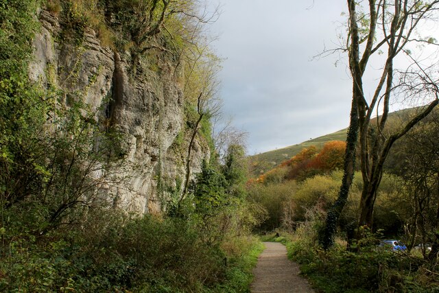
Cramside Wood is a picturesque woodland located in the county of Derbyshire, England. Nestled within the beautiful Peak District National Park, it covers an area of approximately 100 hectares and offers visitors a tranquil escape into nature.

The wood is predominantly comprised of native broadleaf trees, such as oak, beech, and birch, which create a dense canopy overhead. The forest floor is carpeted with a rich diversity of plant species, including bluebells, wild garlic, and wood sorrel, providing a vibrant burst of color during the spring and summer months.

Cramside Wood is home to a wide range of wildlife, making it a popular destination for nature enthusiasts and birdwatchers. Visitors can spot various bird species, including the great spotted woodpecker, tawny owl, and common buzzard. Squirrels scurry through the treetops, while deer can occasionally be spotted grazing in the quieter areas of the wood.

Several well-marked trails wind their way through the wood, offering visitors the chance to explore its natural beauty. These trails cater to both walkers and cyclists, providing a peaceful and scenic route to enjoy the woodland. There are also designated picnic areas and benches where visitors can relax and take in the tranquil surroundings.

Cramside Wood is easily accessible, with a car park located nearby and good public transport links. The wood is open to the public throughout the year, allowing visitors to experience its ever-changing beauty in different seasons. Whether it's a leisurely stroll, a family picnic, or a wildlife-spotting adventure, Cramside Wood offers a delightful escape into nature for all to enjoy.

If you have any feedback on the listing, please let us know in the comments section below.

Cramside Wood Images

Images are sourced within 2km of 53.253635/-1.7516776 or Grid Reference SK1672. Thanks to Geograph Open Source API. All images are credited.

Litton, Bottomhill Road Gatepost BM BM on gatepost, E side of road
Litton, Bottomhill Road Gatepost BM
BM on gatepost, E side of road
Cressbrook, Bottomhill Road BM on roadside wall
Cressbrook, Bottomhill Road
BM on roadside wall
Path in Monsal Dale Looking up the dale. The River Wye is off to the right.
Path in Monsal Dale
Looking up the dale. The River Wye is off to the right.
Cutting on the Monsal Trail Section of the former Manchester to Matlock line, built by the Midland Railway in 1865.
It closed in 1968, with 8.5 miles converted to leisure use - populated by cyclists, walkers and the odd horse rider.
Cutting on the Monsal Trail
Section of the former Manchester to Matlock line, built by the Midland Railway in 1865. It closed in 1968, with 8.5 miles converted to leisure use - populated by cyclists, walkers and the odd horse rider.
Footbridge over the River Wye
The Road to Litton Mill Follows the course of the River Wye through Millers Dale
The Road to Litton Mill
Follows the course of the River Wye through Millers Dale
Footpath at Tongue End looking North West Beginning of the footpath that runs up Tideswell Dale
Footpath at Tongue End looking North West
Beginning of the footpath that runs up Tideswell Dale
The End of the Footpath that runs down Tideswell Dale The footpath reaches the road to Litton Mill, beside the River Wye.
The End of the Footpath that runs down Tideswell Dale
The footpath reaches the road to Litton Mill, beside the River Wye.
Path heading up Tideswell Dale (1)
Path heading up  Tideswell Dale (2) Gradual climb up this limestone dale towards the ancient village of Tideswell.
Path heading up Tideswell Dale (2)
Gradual climb up this limestone dale towards the ancient village of Tideswell.
Public Convenience in the Tideswell Dale Car Park
Tideswell Dale Car Park Car Park in autumn colours
Tideswell Dale Car Park
Car Park in autumn colours
Autumnal Scene in Tideswell Dale Following a footpath through woods, that will eventually lead up to the village of Tideswell.
Autumnal Scene in Tideswell Dale
Following a footpath through woods, that will eventually lead up to the village of Tideswell.
Looking down into Millers Dale from the Monsal Trail
Path down to the River Wye, Millers Dale A path off the Monsal Trail to a footbridge over the Wye. Slippery following rain!
Path down to the River Wye, Millers Dale
A path off the Monsal Trail to a footbridge over the Wye. Slippery following rain!
Entering Tideswell Dale
Ash Requiem 2021, Tideswell Dale Diseased, 'ash dieback' trees were being felled in this area.
Ash Requiem 2021, Tideswell Dale
Diseased, 'ash dieback' trees were being felled in this area.
Public conveniences, Tideswell Dale Car Park
Show me another place!

Cramside Wood is located at Grid Ref: SK1672 (Lat: 53.253635, Lng: -1.7516776)

Administrative County: Derbyshire

District: Derbyshire Dales

Police Authority: Derbyshire

What 3 Words

///found.cosmic.tops. Near Tideswell, Derbyshire

Nearby Locations

Cramside Wood Mill Stream

Related Wikis

Cressbrook

Cressbrook is a village in the Peak District National Park in Derbyshire. It lies in Water-cum-Jolly Dale at the foot of Cressbrook Dale. Population details...

Cressbrook Dale

Cressbrook Dale (also called Ravensdale) is a dry carboniferous limestone gorge near Bakewell, Derbyshire, in the Peak District of England. The dale is...

Litton Mill

Litton Mill is a textile mill at Millers Dale, near Tideswell in Derbyshire. The original 19th-century mill became notorious during the Industrial Revolution...

Monsal Dale railway station

Monsal Dale railway station was opened in 1866 by the Midland Railway on its line from Rowsley, extending the Manchester, Buxton, Matlock and Midlands...

Hubble (climb)

Hubble is a short 10-metre (33 ft) bolted sport climb at the limestone crag of Raven Tor in Miller's Dale, in the Peak District in Derbyshire, England...

Monsal Dale

Monsal Dale is a valley in Derbyshire, England, in the White Peak limestone area of the Peak District National Park. It is a Site of Special Scientific...

Monsal Trail

The Monsal Trail is a cycling, horse riding and walking trail in the Derbyshire Peak District. It was constructed from a section of the former Manchester...

Brushfield

Brushfield is a hamlet and civil parish in the Derbyshire Dales district of Derbyshire, England, in the Peak District National Park. It is about 8 miles...

Nearby Amenities

Located within 500m of 53.253635,-1.7516776
Cressbrook (Phone Box)
Bus: yes
Public Transport: stop_position
Lat/Long: 53.2547334/-1.7469412
Cressbrook
Is In: Derbyshire, England, UK
Place: village
Wikidata: Q5184488
Wikipedia: en:Cressbrook
Lat/Long: 53.2548332/-1.7458863
Barrier: stile
Foot: yes
Lat/Long: 53.2526872/-1.758766
Railway Stories
Information: audioguide
Tourism: information
Lat/Long: 53.2506198/-1.7514074
Water-cum-Jolly Dale
Place: locality
Lat/Long: 53.2520399/-1.745249
Tourism: viewpoint
Lat/Long: 53.2505876/-1.7512625
Post Box
Collection Times: Mo-Fr 09:00; Sa 07:00
Operator: Royal Mail
Post Box Type: lamp
Ref: SK17 84
Royal Cypher: EIIR
Royal Cypher Wikidata: Q33102113
Lat/Long: 53.2546817/-1.7479195
Defibrillator
HE Ref: 1140150
Access: yes
Booth: K6
Check Date: 2023-03-09
Covered: booth
Defibrillator Location: in red phone box in Cressbrook
Disused Amenity: telephone
Emergency: defibrillator
Indoor: no
Listed Status: Grade II
Source: survey
Wikidata: Q26432945
Lat/Long: 53.2547026/-1.746909
HE Ref: 1158755
Historic: memorial
Listed Status: Grade II
Memorial: war_memorial
Source: survey
Wikidata: Q26452500
Lat/Long: 53.2548001/-1.7469444
Bus Stop
Cressbrook (Phone Box)
Bench: no
Bus: yes
Public Transport: platform
Shelter: no
Source: survey
Lat/Long: 53.2547042/-1.7469441
Cressbrook Dale
Place: locality
Lat/Long: 53.2550664/-1.7527726
Access: no
Barrier: stile
Foot: permissive
Material: wood
Step Count: 2
Stile: stepover
Lat/Long: 53.2510178/-1.7527826
Historic: mine_shaft
Lat/Long: 53.2531992/-1.7544478
Natural: cave_entrance
Lat/Long: 53.25264/-1.7576759
Disused: yes
Man Made: mineshaft
Lat/Long: 53.2530386/-1.7557383
Whittle's Weir
Waterway: weir
Lat/Long: 53.2539134/-1.7523772
Cramside Wood Nature Reserve
Board Type: nature
Information: board
Tourism: information
Lat/Long: 53.2549669/-1.7542733
Fixme: Needs continuing
Lat/Long: 53.2504303/-1.7492698
Grit Bin
Seasonal: no
Lat/Long: 53.25464/-1.7489562
Bench
Openbenches Id: 31038
Lat/Long: 53.2560889/-1.7509541
Tourism: information
Lat/Long: 53.2547035/-1.7472384
Waste Basket
Waste: dog_excrement
Lat/Long: 53.2549102/-1.7452642
Bench
Openbenches Id: 31039
Lat/Long: 53.2548168/-1.7455774
Bench
Lat/Long: 53.2548225/-1.7455504
Wild Peak Rounds: Cramside Wood
Tourism: information
Lat/Long: 53.2516167/-1.7485847
The data included in this document is from www.openstreetmap.org. The data is made available under ODbL.

Have you been to Cramside Wood?

Leave your review of Cramside Wood below (or comments, questions and feedback).