Bewes Hills
Wood, Forest in Durham
England
Bewes Hills

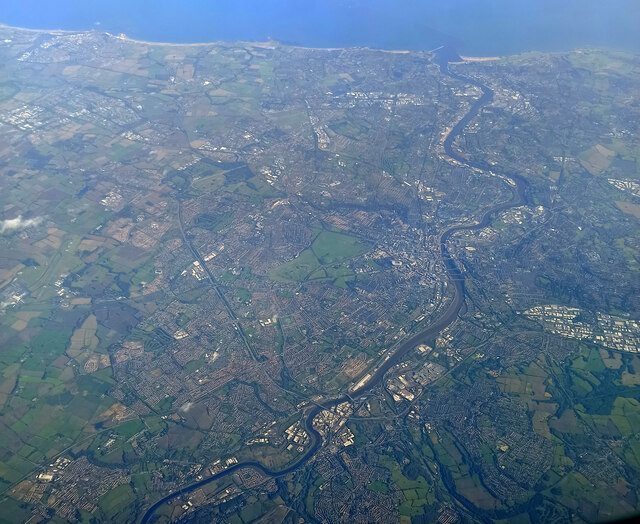
Bewes Hills, also known as Wood or Forest in Durham, is a picturesque and idyllic area located in the northeast region of England. Situated within the County Durham district, this charming village is surrounded by lush greenery, rolling hills, and dense woodlands, making it a haven for nature lovers and outdoor enthusiasts.
The name "Bewes Hills" itself suggests the abundant presence of hills in the area, offering breathtaking panoramic views of the surrounding landscape. The village is known for its tranquil and peaceful atmosphere, providing a respite from the hustle and bustle of city life.
With its rich history dating back centuries, Bewes Hills boasts a number of historical landmarks and architectural marvels. The village is home to several well-preserved medieval buildings, including a church that stands as a testament to the area's religious heritage.
The community in Bewes Hills is tight-knit and welcoming, with friendly locals who take pride in their village. The village often hosts various events and festivals throughout the year, showcasing the local culture and traditions.
For those seeking outdoor activities, Bewes Hills offers ample opportunities for hiking, cycling, and exploring the surrounding woodlands. The area is also known for its diverse wildlife, making it a popular spot for birdwatching and nature photography.
Overall, Bewes Hills, Durham (Wood, Forest) is a serene and picturesque village that offers a peaceful retreat for visitors and residents alike. With its stunning natural beauty, rich history, and welcoming community, it is no wonder that this area has become a hidden gem in the heart of County Durham.
If you have any feedback on the listing, please let us know in the comments section below.
Bewes Hills Images
Images are sourced within 2km of 54.96215/-1.7415773 or Grid Reference NZ1663. Thanks to Geograph Open Source API. All images are credited.


Bewes Hills is located at Grid Ref: NZ1663 (Lat: 54.96215, Lng: -1.7415773)
Unitary Authority: Gateshead
Police Authority: Northumbria
What 3 Words
///using.nasal.notion. Near Blaydon-on-Tyne, Tyne & Wear
Nearby Locations
Related Wikis
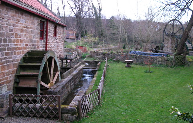
Path Head Watermill
Path Head Mill is an 18th-century watermill at Summerhill on Blaydon Burn, between Blaydon and Stella, near Gateshead in north-east England. The Vale Mill...

Crookhill
Crookhill is an area of Ryton in Tyne and Wear, England. The original terraced housing was built mostly as accommodation for NCB workers, and lies to the...
Addison and Hedgefield Reserve
Addison and Hedgefield Reserve is a woodland area located in the region of Gateshead, United Kingdom, situated to the north of the B6317 to the west of...
Stella, Gateshead
Stella is a community in the Metropolitan Borough of Gateshead, Tyne and Wear, England. It lies on the south bank of the Tyne, about 5 miles (8 km) west...
Nearby Amenities
Located within 500m of 54.96215,-1.7415773Have you been to Bewes Hills?
Leave your review of Bewes Hills below (or comments, questions and feedback).