Heath Plantation

Wood, Forest in Wiltshire

England

Heath Plantation

Gopher Wood, Wiltshire Bluebells, almost at their best, in Gopher Wood.
Gopher Wood, Wiltshire Credit: Rebecca A Wills

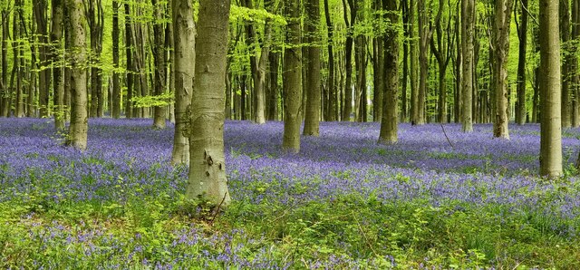
Heath Plantation, located in Wiltshire, England, is a picturesque woodland area renowned for its scenic beauty and diverse flora and fauna. Spread across a sprawling area, this woodland paradise offers a tranquil escape from the hustle and bustle of city life.

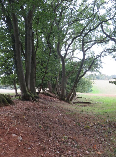
The plantation primarily consists of a mix of deciduous and evergreen trees, creating a lush green canopy that stretches as far as the eye can see. The dense foliage provides a habitat for a wide array of wildlife, including various species of birds, small mammals, and insects.

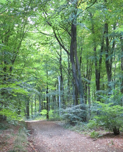
Heath Plantation is a popular destination for nature enthusiasts and hikers, boasting a network of well-maintained walking trails that wind their way through the woods. These paths offer stunning views of the surrounding landscape and provide opportunities to observe the abundant wildlife in their natural habitat.

The plantation also serves as an important ecological site, with several rare and protected species of plants and animals calling it home. Conservation efforts are in place to ensure the preservation and protection of these valuable species.

In addition to its natural beauty, Heath Plantation offers a range of recreational activities for visitors. Picnic areas are scattered throughout the woodland, providing the perfect spot to relax and enjoy the serene surroundings. The plantation is also a popular destination for camping, with designated camping sites available for overnight stays.

Overall, Heath Plantation in Wiltshire is a haven for nature lovers, offering a peaceful retreat amidst stunning woodlands, a haven for wildlife, and a wealth of recreational activities for visitors to enjoy.

If you have any feedback on the listing, please let us know in the comments section below.

Heath Plantation Images

Images are sourced within 2km of 51.389788/-1.7870511 or Grid Reference SU1465. Thanks to Geograph Open Source API. All images are credited.

Gopher Wood, Wiltshire Bluebells, almost at their best, in Gopher Wood.
Gopher Wood, Wiltshire
Bluebells, almost at their best, in Gopher Wood.
Pickrudge, West Woods Bluebells in the area of Pickrudge, within West Woods.
Pickrudge, West Woods
Bluebells in the area of Pickrudge, within West Woods.
Foxbury Copse, West Woods Bluebells and a track within Foxbury Copse (part of West Woods).
Foxbury Copse, West Woods
Bluebells and a track within Foxbury Copse (part of West Woods).
Wools Grove, West Woods Bluebells in Wools Grove, within West Woods.
Wools Grove, West Woods
Bluebells in Wools Grove, within West Woods.
Access track to West Woods car park Woodland managed by Forestry England.
Access track to West Woods car park
Woodland managed by Forestry England.
Shady picnic tables at West Woods car park
Thatched cottages at Lockeridge Now a single dwelling and known as number 41. The cottage faces out on to the lower part of Lockeridge Dene, an NT protected area noted for sarsen stones, a few of which can be seen here. The area once had a wide covering of sarsen, but many were used for building cottages like this one, walls and other structures, including the monuments of Stonehenge, Avebury, West Kennet Long Barrow etc.
Thatched cottages at Lockeridge
Now a single dwelling and known as number 41. The cottage faces out on to the lower part of Lockeridge Dene, an NT protected area noted for sarsen stones, a few of which can be seen here. The area once had a wide covering of sarsen, but many were used for building cottages like this one, walls and other structures, including the monuments of Stonehenge, Avebury, West Kennet Long Barrow etc.
Lockeridge Dene An area of sarsen stones at the southern end of the village, now under the care of the National Trust.
Lockeridge Dene
An area of sarsen stones at the southern end of the village, now under the care of the National Trust.
Parking area on the edge of West Woods Not signposted on any road out of Lockeridge, and presumably used mostly by local dog walkers.
Parking area on the edge of West Woods
Not signposted on any road out of Lockeridge, and presumably used mostly by local dog walkers.
Dappled sunlight, West Woods West Woods are a large area of ancient woodland which at one time may have been joined to Savernake Forest. This might be ancient woodland recorded for 400 years or so, but one would have to search long and hard for any really ancient trees.
Dappled sunlight, West Woods
West Woods are a large area of ancient woodland which at one time may have been joined to Savernake Forest. This might be ancient woodland recorded for 400 years or so, but one would have to search long and hard for any really ancient trees.
Track in West Woods This track is shown as a 'BOAT' on OS maps and is also the course of the Wansdyke Path. The Wansdyke is off picture to the left and is quite insignificant at this point.
Track in West Woods
This track is shown as a 'BOAT' on OS maps and is also the course of the Wansdyke Path. The Wansdyke is off picture to the left and is quite insignificant at this point.
Slight remains of Wansdyke The low mount surmounted by trees marks the Wansdyke bank, but the ditch to the right has largely disappeared thanks to some 1500 years of slow infill.
The Wansdyke still has an air of mystery. Who built it and why?  It appears to be post Roman in date as at one point it crosses a Roman Road, whilst the ditch is on the north side, which suggests that if it was a defensive line, then it was defending land to the south.
Slight remains of Wansdyke
The low mount surmounted by trees marks the Wansdyke bank, but the ditch to the right has largely disappeared thanks to some 1500 years of slow infill. The Wansdyke still has an air of mystery. Who built it and why? It appears to be post Roman in date as at one point it crosses a Roman Road, whilst the ditch is on the north side, which suggests that if it was a defensive line, then it was defending land to the south.
Deserted Medieval Village site This is the site of the medieval village of Shaw, about which very little is known as the site has never been fully excavated. There is some evidence of a very small church which would have been to the right of this photo, whilst the village may have extended across neighbouring fields where centuries of agriculture has destroyed evidence. Anyone expecting to see an interesting area of lumps and bumps will be disappointed due to the tall vegetation. maybe a winter visit with low sunlight might prove better.
Deserted Medieval Village site
This is the site of the medieval village of Shaw, about which very little is known as the site has never been fully excavated. There is some evidence of a very small church which would have been to the right of this photo, whilst the village may have extended across neighbouring fields where centuries of agriculture has destroyed evidence. Anyone expecting to see an interesting area of lumps and bumps will be disappointed due to the tall vegetation. maybe a winter visit with low sunlight might prove better.
Downland country A fold in the hills near the old village site of Shaw. Open views here, but the bridleway heading towards Gopher Wood turned out to be a fight with brambles, nettles and thistles. Riding a horse or bike through here would be nigh on impossible.
Downland country
A fold in the hills near the old village site of Shaw. Open views here, but the bridleway heading towards Gopher Wood turned out to be a fight with brambles, nettles and thistles. Riding a horse or bike through here would be nigh on impossible.
Testing times ahead The gate marks the start of an enclosed section of bridleway heading towards a junction with the Wansdyke Path near the DMV of Shaw. The next 500m or so will test clothing [and legs if wearing shorts] as parts of the path are very narrow and lined with thorn bushes, brambles, nettles and thistles. A fine route for masochists.
Testing times ahead
The gate marks the start of an enclosed section of bridleway heading towards a junction with the Wansdyke Path near the DMV of Shaw. The next 500m or so will test clothing [and legs if wearing shorts] as parts of the path are very narrow and lined with thorn bushes, brambles, nettles and thistles. A fine route for masochists.
Path into the vale There's a meeting of at least six paths near the NE corner of Gopher Wood, this one heads south downhill towards Huish in the Vale of Pewsey.
Path into the vale
There's a meeting of at least six paths near the NE corner of Gopher Wood, this one heads south downhill towards Huish in the Vale of Pewsey.
Path towards West Woods Bridleway which is probably part of an old route from Huish to Lockeridge and is now part of the White Horse Trail.
Path towards West Woods
Bridleway which is probably part of an old route from Huish to Lockeridge and is now part of the White Horse Trail.
Clearing in Hursley Bottom A clearing in West Woods, complete with picnic table.
Clearing in Hursley Bottom
A clearing in West Woods, complete with picnic table.
Show me another place!

Heath Plantation is located at Grid Ref: SU1465 (Lat: 51.389788, Lng: -1.7870511)

Unitary Authority: Wiltshire

Police Authority: Wiltshire

What 3 Words

///agreeable.triads.region. Near Huish, Wiltshire

Related Wikis

Lockeridge

Lockeridge is a village in Wiltshire, England. It lies at the edge of the West Woods in the Kennet Valley, 2.9 miles (4.7 km) west of Marlborough, 3.1...

Huish, Wiltshire

Huish is a small village and former civil parish, now in the parish of Wilcot, Huish and Oare, in Wiltshire, England, 2 miles (3.2 km) northwest of Pewsey...

Oare Pavilion

The Oare Pavilion or Oare Tea House Pavilion is a summer house designed by I. M. Pei for the businessman Henry Keswick and his wife Tessa Keswick at Oare...

Oare House

Oare House is a Grade I listed country house in Oare, Wiltshire, England.The house was built in 1740 for a London wine merchant, Henry Deacon. It was largely...

Oare, Wiltshire

Oare is a small village in the east of the county of Wiltshire, England. The village lies about 2 miles (3.2 km) north of Pewsey, on the A345 road towards...

West Overton

West Overton is a village and civil parish in the English county of Wiltshire, about 3.5 miles (5.6 km) west of Marlborough. The river Kennet runs immediately...

Clatford

Clatford is a small hamlet (formerly a village) approximately 1 mile (1.6 km) west of the village of Manton and about 2 miles (3.2 km) west of Marlborough...

Fyfield (near Marlborough)

Fyfield is a village and civil parish in the English county of Wiltshire, in the Kennet Valley about 2.5 miles (4.0 km) west of Marlborough. The village...

Nearby Amenities

Located within 500m of 51.389788,-1.7870511
Pickrudge
Natural: wood
Lat/Long: 51.3904677/-1.7919311
Bench: yes
Leisure: picnic_table
Lit: no
Lat/Long: 51.3940568/-1.7880111
The data included in this document is from www.openstreetmap.org. The data is made available under ODbL.

Have you been to Heath Plantation?

Leave your review of Heath Plantation below (or comments, questions and feedback).