Bog Wood

Wood, Forest in Durham

England

Bog Wood

Nacreous clouds over Heddon Common Polar stratospheric clouds, also known as nacreous and mother-of-pearl clouds, are formed of small water droplets or usually ice crystals of nearly uniform size. When the Sun is in the right position and, typically, hidden from direct view, these thin clouds can be seen significantly diffracting sunlight in a nearly coherent manner, with different colours being deflected by different amounts. They  form when cold temperatures in the usually cloudless lower stratosphere form ice crystals. They remain sunlit at altitudes of around 15 to 25 kilometres even after sunset and just before the dawn. 
<span class="nowrap"><a title="https://apod.nasa.gov/apod/ap200115.html" rel="nofollow ugc noopener" href="https://apod.nasa.gov/apod/ap200115.html">Link</a><img style="margin-left:2px;" alt="External link" title="External link - shift click to open in new window" src="https://s1.geograph.org.uk/img/external.png" width="10" height="10"/></span>
Nacreous clouds over Heddon Common Credit: Andrew Curtis

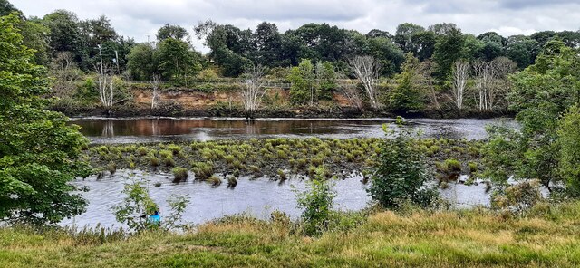
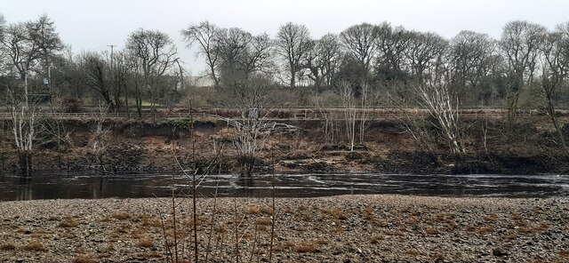
Bog Wood, located in Durham, England, is a unique and enchanting forest known for its ancient and preserved woodlands. Situated in the heart of the Durham Dales, this picturesque area covers a vast expanse of approximately 200 hectares.

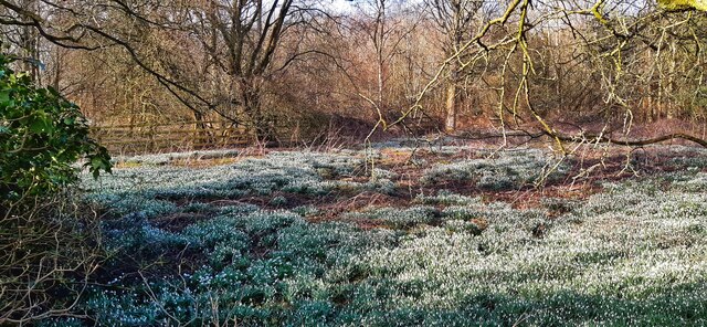
The forest gets its name from the presence of peat bogs, which are a defining feature of the landscape. These bogs have formed over thousands of years and are home to a diverse range of plant and animal species. The wet conditions of the bogs create a specialized habitat that supports rare and delicate flora, including sphagnum mosses and carnivorous plants such as sundews and butterworts.

The woodland itself is dominated by dense stands of oak, birch, and rowan trees, which provide shelter and food for a variety of wildlife. Visitors to Bog Wood may be lucky enough to spot red squirrels, roe deer, and a variety of bird species, including the elusive nightjar.

The forest is crisscrossed by a network of walking trails, allowing visitors to explore its natural wonders at their own pace. These trails offer stunning views of the surrounding countryside, with rolling hills and meandering streams adding to the area's charm.

Bog Wood is not only a haven for nature enthusiasts but also a valuable site for scientific research and conservation efforts. Its unique ecosystem provides insights into the region's ecological history and has led to the protection and preservation of this extraordinary woodland for future generations to enjoy.

If you have any feedback on the listing, please let us know in the comments section below.

Bog Wood Images

Images are sourced within 2km of 54.978015/-1.7910183 or Grid Reference NZ1364. Thanks to Geograph Open Source API. All images are credited.

Nacreous clouds over Heddon Common Polar stratospheric clouds, also known as nacreous and mother-of-pearl clouds, are formed of small water droplets or usually ice crystals of nearly uniform size. When the Sun is in the right position and, typically, hidden from direct view, these thin clouds can be seen significantly diffracting sunlight in a nearly coherent manner, with different colours being deflected by different amounts. They  form when cold temperatures in the usually cloudless lower stratosphere form ice crystals. They remain sunlit at altitudes of around 15 to 25 kilometres even after sunset and just before the dawn. 
<span class="nowrap"><a title="https://apod.nasa.gov/apod/ap200115.html" rel="nofollow ugc noopener" href="https://apod.nasa.gov/apod/ap200115.html">Link</a><img style="margin-left:2px;" alt="External link" title="External link - shift click to open in new window" src="https://s1.geograph.org.uk/img/external.png" width="10" height="10"/></span>
Nacreous clouds over Heddon Common
Polar stratospheric clouds, also known as nacreous and mother-of-pearl clouds, are formed of small water droplets or usually ice crystals of nearly uniform size. When the Sun is in the right position and, typically, hidden from direct view, these thin clouds can be seen significantly diffracting sunlight in a nearly coherent manner, with different colours being deflected by different amounts. They form when cold temperatures in the usually cloudless lower stratosphere form ice crystals. They remain sunlit at altitudes of around 15 to 25 kilometres even after sunset and just before the dawn. LinkExternal link
Somewhere over the rainbow A plane flies south from Newcastle Airpoprt above a fine display of nacreous rainbow clouds just after sunrise.
Somewhere over the rainbow
A plane flies south from Newcastle Airpoprt above a fine display of nacreous rainbow clouds just after sunrise.
Nacreous clouds at sunrise
Ryton Church spire above River Tyne A collection of photographs taken around midday by Geographers from all over Britain and Ireland. 
See all the images on the map: <a title="https://www.geograph.org.uk/stuff/xmas.php?year=2023" href="https://www.geograph.org.uk/stuff/xmas.php?year=2023">Link</a>
Ryton Church spire above River Tyne
A collection of photographs taken around midday by Geographers from all over Britain and Ireland. See all the images on the map: Link
Spider's web on tree Unlike the orb web <a href="https://www.geograph.org.uk/photo/6942715">NZ1266 : Spider's web on tree</a>, the sheet webs are densely woven, thin, horizontal sheets which look like silken hammocks often built on stems of grass or low bushes. On this garden conifer the webs stand out on a misty mid-summer morning. Bugs fall onto the hammocks or get knocked down when they collide with a tangle of threads above the sheet.

Sheet webs are usually built by the Linyphiidae. This is the largest family of spiders in the UK, with 280 species. It includes the tiny money spiders said to bring good luck if you find one wandering over you.
<span class="nowrap"><a title="https://www.nhm.ac.uk/discover/spider-webs.html" rel="nofollow ugc noopener" href="https://www.nhm.ac.uk/discover/spider-webs.html">Link</a><img style="margin-left:2px;" alt="External link" title="External link - shift click to open in new window" src="https://s1.geograph.org.uk/img/external.png" width="10" height="10"/></span>
Spider's web on tree
Unlike the orb web NZ1266 : Spider's web on tree, the sheet webs are densely woven, thin, horizontal sheets which look like silken hammocks often built on stems of grass or low bushes. On this garden conifer the webs stand out on a misty mid-summer morning. Bugs fall onto the hammocks or get knocked down when they collide with a tangle of threads above the sheet. Sheet webs are usually built by the Linyphiidae. This is the largest family of spiders in the UK, with 280 species. It includes the tiny money spiders said to bring good luck if you find one wandering over you. LinkExternal link
Spider's web on tree Classic orb web on garden conifer.

A two-dimensional web that look like a bicycle wheel or dart board.

Orb webs are constructed with radial threads that function as a scaffold. The spider then lays down sticky threads in a spiral.
<span class="nowrap"><a title="https://www.nhm.ac.uk/discover/spider-webs.html" rel="nofollow ugc noopener" href="https://www.nhm.ac.uk/discover/spider-webs.html">Link</a><img style="margin-left:2px;" alt="External link" title="External link - shift click to open in new window" src="https://s1.geograph.org.uk/img/external.png" width="10" height="10"/></span>
Spider's web on tree
Classic orb web on garden conifer. A two-dimensional web that look like a bicycle wheel or dart board. Orb webs are constructed with radial threads that function as a scaffold. The spider then lays down sticky threads in a spiral. LinkExternal link
Common green shieldbug nymph on stinging nettle Common Green Shieldbug (Palomena prasina) undergoes hemimetabolic development in that they have no larval stage and so they emerge as miniature adults or nymphs. The young go through 5 stages of growth pre-adulthood and these are known as instars. The primary instar has dark colouration and the green colouration, caused by serrations in their exoskeleton refracting light, becomes more prevalent with age.
<span class="nowrap"><a title="https://biomeecology.com/nature/2016/04/the-life-of-a-common-green-shieldbug" rel="nofollow ugc noopener" href="https://biomeecology.com/nature/2016/04/the-life-of-a-common-green-shieldbug">Link</a><img style="margin-left:2px;" alt="External link" title="External link - shift click to open in new window" src="https://s1.geograph.org.uk/img/external.png" width="10" height="10"/></span>

A recent beneficiary of climate change, the common green shieldbug was once restricted to Southern England. In recent years, however, it has been on the march, and is now common and widespread across much of England and Wales, and spreading further northwards.
<span class="nowrap"><a title="https://www.ywt.org.uk/wildlife-explorer/invertebrates/bugs/common-green-shieldbug" rel="nofollow ugc noopener" href="https://www.ywt.org.uk/wildlife-explorer/invertebrates/bugs/common-green-shieldbug">Link</a><img style="margin-left:2px;" alt="External link" title="External link - shift click to open in new window" src="https://s1.geograph.org.uk/img/external.png" width="10" height="10"/></span>
Common green shieldbug nymph on stinging nettle
Common Green Shieldbug (Palomena prasina) undergoes hemimetabolic development in that they have no larval stage and so they emerge as miniature adults or nymphs. The young go through 5 stages of growth pre-adulthood and these are known as instars. The primary instar has dark colouration and the green colouration, caused by serrations in their exoskeleton refracting light, becomes more prevalent with age. LinkExternal link A recent beneficiary of climate change, the common green shieldbug was once restricted to Southern England. In recent years, however, it has been on the march, and is now common and widespread across much of England and Wales, and spreading further northwards. LinkExternal link
September morning sunrise
Rear of The Swan, Heddon on the Wall
The Swan, Towne Gate, Heddon on the Wall
Towne Gate, Heddon on the Wall Near junction with Heddon Banks.
Towne Gate, Heddon on the Wall
Near junction with Heddon Banks.
Erosion of south bank of River Tyne By 3rd February 2021, 5 months after this photo was taken, there was a further landslip in this location leading to closure of the footpath and cycle route <a href="https://www.geograph.org.uk/photo/6995543">NZ1264 : Landslip on south bank of River Tyne</a>

"A section of the Keelman's Way, the popular walking and cycling route linking Wylam with Gateshead Quays, has had to be closed due to the imminent risk of the river bank collapsing.

The Keelman's Way, which follows the south bank of the River Tyne all the way from Wylam to Gateshead Quays, has had to be closed after large cracks and collapses of the river bank have affected the stability of the path.

The decision to close the footpath was taken in the interests of public safety and will mean that there will be no direct pedestrian or cycle access between Wylam railway station and Ryton for the foreseeable future.

Closure signs are now being erected and a diversion route is being devised, though this is likely to be lengthy.

Network Rail, whose main Newcastle-Carlisle rail line runs close to the footpath, has also been alerted.

Gateshead Council has been monitoring the erosion of the river bank east of Wylam railway station for some years since changes were observed in the flow of the River Tyne which were leading to increased erosion of the south bank of the river. The land on which the erosion is taking place - and on which the Keelman's Way runs -  is privately-owned.

Options for the long term future of the riverside path will now need to be examined."

<span class="nowrap"><a title="https://www.gateshead.gov.uk/article/17433/Keelman-Way-closed-at-Wylam-due-to-landslip" rel="nofollow ugc noopener" href="https://www.gateshead.gov.uk/article/17433/Keelman-Way-closed-at-Wylam-due-to-landslip">Link</a><img style="margin-left:2px;" alt="External link" title="External link - shift click to open in new window" src="https://s1.geograph.org.uk/img/external.png" width="10" height="10"/></span>
Erosion of south bank of River Tyne
By 3rd February 2021, 5 months after this photo was taken, there was a further landslip in this location leading to closure of the footpath and cycle route NZ1264 : Landslip on south bank of River Tyne "A section of the Keelman's Way, the popular walking and cycling route linking Wylam with Gateshead Quays, has had to be closed due to the imminent risk of the river bank collapsing. The Keelman's Way, which follows the south bank of the River Tyne all the way from Wylam to Gateshead Quays, has had to be closed after large cracks and collapses of the river bank have affected the stability of the path. The decision to close the footpath was taken in the interests of public safety and will mean that there will be no direct pedestrian or cycle access between Wylam railway station and Ryton for the foreseeable future. Closure signs are now being erected and a diversion route is being devised, though this is likely to be lengthy. Network Rail, whose main Newcastle-Carlisle rail line runs close to the footpath, has also been alerted. Gateshead Council has been monitoring the erosion of the river bank east of Wylam railway station for some years since changes were observed in the flow of the River Tyne which were leading to increased erosion of the south bank of the river. The land on which the erosion is taking place - and on which the Keelman's Way runs -  is privately-owned. Options for the long term future of the riverside path will now need to be examined." LinkExternal link
Winter walk at Broomy Hill Monochrome in a monochrome world.
Winter walk at Broomy Hill
Monochrome in a monochrome world.
Heddon Common View south over the Tyne Valley.
Heddon Common
View south over the Tyne Valley.
Landslip on south bank of River Tyne See description on earlier photo <a href="https://www.geograph.org.uk/photo/6991732">NZ1264 : Erosion of south bank of River Tyne</a>

This photo, taken shortly after the landslip that resulted in closure of the Keelman's Way, shows the collapse of a section of the fence erected for safety. In this section the path occupies a narrow space between the river cliff and the Newcastle-Carlisle railway line.
Landslip on south bank of River Tyne
See description on earlier photo NZ1264 : Erosion of south bank of River Tyne This photo, taken shortly after the landslip that resulted in closure of the Keelman's Way, shows the collapse of a section of the fence erected for safety. In this section the path occupies a narrow space between the river cliff and the Newcastle-Carlisle railway line.
Carpet of snowdrops on old colliery site off Station Road
Victrix, Taberna Close, Heddon on the Wall Photo taken in May 2021 after the installation of new information board.

See description here <a href="https://www.geograph.org.uk/photo/5970948">NZ1366 : 'Victrix', Taberna Close, Heddon on the Wall</a>
Victrix, Taberna Close, Heddon on the Wall
Photo taken in May 2021 after the installation of new information board. See description here NZ1366 : 'Victrix', Taberna Close, Heddon on the Wall
Flooded farmland east of Heddon Haughs
Show me another place!

Bog Wood is located at Grid Ref: NZ1364 (Lat: 54.978015, Lng: -1.7910183)

Unitary Authority: Gateshead

Police Authority: Northumbria

What 3 Words

///pass.reds.glitz. Near Wylam, Northumberland

Related Wikis

Clara Vale

Clara Vale is a village situated on the south bank of the River Tyne in Tyne and Wear, England. Once an independent village in County Durham it became...

Ryton & Crawcrook Albion F.C.

Ryton & Crawcrook Albion Football Club is a semi-professional English non-league football club from Crawcrook, near Ryton, Newcastle upon Tyne, in Tyne...

George Stephenson's Birthplace

George Stephenson's Birthplace is the 18th-century stone cottage home of rail pioneer George Stephenson. Located along the north bank of the River Tyne...

Heddon-on-the-Wall railway station

Heddon-on-the-Wall railway station served the village of Heddon-on-the-Wall, Northumberland, England from 1881 to 1958. == History == The station opened...

British Masters

The Betfred British Masters is a professional golf tournament. It was founded in 1946 as the Dunlop Masters and was held every year up to 2008, except...

Close House, Northumberland

Close House is a country estate near Heddon-on-the-Wall, Northumberland. The estate contains a Grade II* listed former mansion house, which is currently...

Crawcrook

Crawcrook is a semi-rural village close to the western border of the metropolitan county of Tyne and Wear in England. Traditionally an independent village...

Wylam railway station

Wylam is a railway station on the Tyne Valley Line, which runs between Newcastle and Carlisle via Hexham. The station, situated 9 miles 71 chains (9.89...

Nearby Amenities

Located within 500m of 54.978015,-1.7910183
Source: PGS
Lat/Long: 54.9816094/-1.7956383
Created By: almien_coastlines
Source: PGS
Lat/Long: 54.9811617/-1.7963421
Created By: almien_coastlines
Source: PGS
Lat/Long: 54.9807837/-1.7970211
Clara Vale
Is In: Gateshead, England, UK
Place: village
Postal Code: NE40 3
Wikidata: Q5126056
Wikipedia: en:Clara Vale
Lat/Long: 54.9797324/-1.7922674
Post Box
Ref: NE40 79
Lat/Long: 54.9792402/-1.7922044
Clara Vale War Memorial
Historic: memorial
Lat/Long: 54.9785813/-1.7918282
Crossing Barrier: half
Crossing Bell: yes
Crossing Light: yes
Railway: level_crossing
Lat/Long: 54.9803641/-1.7931729
Barrier: kissing_gate
Foot: yes
Lat/Long: 54.977641/-1.7972462
Maryside Hill
Ele: 51
Man Made: survey_point
Ref: S4429
Tpuk Ref: TP4685
Lat/Long: 54.9779409/-1.785449
Barrier: stile
Lat/Long: 54.9773848/-1.7963856
Edington Well
Disused Man Made: water_well
Lat/Long: 54.9770546/-1.7879174
Barrier: stile
Lat/Long: 54.9760567/-1.7874835
Barrier: kissing_gate
Foot: yes
Lat/Long: 54.9778786/-1.7970903
The Alex West Hide
Building: yes
Leisure: bird_hide
Note: Access info https://www.gateshead.gov.uk/article/4395/Bird-Hides
Lat/Long: 54.9781979/-1.7980156
Power: substation
Lat/Long: 54.9785994/-1.7949185
Barrier: stile
Lat/Long: 54.9775321/-1.7963591
Building: yes
Leisure: bird_hide
Lat/Long: 54.9779061/-1.7972048
Barrier: stile
Lat/Long: 54.9786464/-1.7959694
Bus Stop
STANNERFORD ROAD-FARM-N/B
Local Ref: NE
Naptan AtcoCode: 410000012053
Naptan Bearing: NE
Naptan CommonName: STANNERFORD ROAD-FARM-N/B
Naptan Indicator: NE
Naptan Landmark: OUTSIDE BUILDING FARM
Naptan NaptanCode: twratmwa
Naptan Street: STANNERFORD
Naptan Verified: no
Source: naptan_import
Lat/Long: 54.9748257/-1.7888976
Bus Stop
STANNERFORD ROAD-EAST VIEW
Local Ref: N
Naptan AtcoCode: 410000012054
Naptan Bearing: N
Naptan CommonName: STANNERFORD ROAD-EAST VIEW
Naptan Indicator: N
Naptan Landmark: OPPOSITE CLARA VALE JUNIOR AND INFANTS SCHOOL
Naptan NaptanCode: twratmwd
Naptan Street: STANNERFORD ROAD
Naptan Verified: no
Source: naptan_import
Lat/Long: 54.9791087/-1.7923458
Bus Stop
CLARA VALE
Local Ref: S
Naptan AtcoCode: 410000012055
Naptan Bearing: S
Naptan CommonName: CLARA VALE
Naptan Indicator: S
Naptan Landmark: OUTSIDE CLARA VALE JUNIOR AND INFANTS SCHOOL
Naptan NaptanCode: twratmwg
Naptan Street: STANNERFORD ROAD
Naptan Verified: no
Source: naptan_import
Lat/Long: 54.9789754/-1.7920843
Bus Stop
STANNERFORD ROAD-FARM-S/B
Local Ref: SW
Naptan AtcoCode: 410000012056
Naptan Bearing: SW
Naptan CommonName: STANNERFORD ROAD-FARM-S/B
Naptan Indicator: SW
Naptan Landmark: OPPOSITE BUILDING FARM
Naptan NaptanCode: twratmwj
Naptan Street: STANNERFORD ROAD
Naptan Verified: no
Source: naptan_import
Lat/Long: 54.974804/-1.7887785
Power: substation
Lat/Long: 54.9794273/-1.7913401
Board Type: nature
Information: board
Tourism: information
Lat/Long: 54.9784868/-1.7953037
Bench
The Blather Bench
Lat/Long: 54.9786214/-1.7919177
Board Type: nature
Information: board
Tourism: information
Lat/Long: 54.9776358/-1.797203
Barrier: stile
Lat/Long: 54.9784934/-1.7969924
Bbq
Material: brick
Lat/Long: 54.9786219/-1.7952962
Bench
Material: wood
Lat/Long: 54.9776579/-1.7969238
Bench
Material: wood
Lat/Long: 54.978361/-1.7955769
Bench
Source: gps;survey
Lat/Long: 54.9794921/-1.7911866
Bench
Source: gps;survey
Lat/Long: 54.9799125/-1.7921079
Historic: memorial
Inscription: Formerly the Church of the Good Shepherd. This Centenary Garden is dedicated to the miners and their families who created this village. 1891 - 1991. "How bright these glorious spirits shine".
Lat/Long: 54.9799195/-1.7920721
Bench
Source: gps;survey
Lat/Long: 54.9807861/-1.7894486
Bench
Source: gps;survey
Lat/Long: 54.980993/-1.7884776
Leisure: picnic_table
Source: gps;survey
Lat/Long: 54.9810055/-1.7885863
Bench
Source: gps;survey
Lat/Long: 54.9811523/-1.7880908
Crossing Barrier: half
Crossing Bell: yes
Crossing Light: yes
Railway: level_crossing
Lat/Long: 54.9803314/-1.7931471
Baking Oven
Oven: wood_fired
Lat/Long: 54.9792076/-1.7914273
Disc Golf: basket
Sport: disc_golf
Lat/Long: 54.9785236/-1.798733
Barrier: bollard
Lat/Long: 54.9749224/-1.7884963
Waste Basket
Lat/Long: 54.9791268/-1.7923748
Entrance: main
Lat/Long: 54.9792071/-1.7918319
Board Type: notice
Information: board
Tourism: information
Lat/Long: 54.9792503/-1.7921716
Leisure: picnic_table
Lat/Long: 54.9790021/-1.7919905
Bicycle Parking
Bicycle Parking: stands
Capacity: 8
Covered: no
Lat/Long: 54.9790783/-1.7918001
Bench
Source: gps;survey
Lat/Long: 54.9793484/-1.791092
Waste Basket
Lat/Long: 54.9794824/-1.7912395
Leisure: picnic_table
Lat/Long: 54.9793915/-1.7912275
Clara Vale Community Orchard
Board Type: notice
Information: board
Tourism: information
Lat/Long: 54.9810246/-1.7891581
Charging Station
Amperage: 32
Brand: Project EV
Capacity: 2
Location: wall
Network: Project EV
Note: Two units mounted on SE corner. No cables.
Parking Fee: no
Ref: 5436;5437
Ref EU EVSE: 5436;5437
Socket Type2: 2
Socket Type2 Output: 7 kW
Voltage: 230
Website: https://www.claravale.org.uk/hire-the-hall/ev-charging/
Lat/Long: 54.9792431/-1.7915524
Recycling
Operator: Dragonfly Cancer Trust
Recycling Clothes: yes
Recycling Shoes: yes
Recycling Type: container
Lat/Long: 54.9793869/-1.7915399
Defibrillator
Defibrillator Location: On wall beside villlage noticeboard and driveway entrance to community centre
Emergency: defibrillator
Opening Hours: 24/7
Outdoor: yes
Ref: NE403SY
Lat/Long: 54.9792592/-1.7921327
Generator Method: photovoltaic
Generator Output Electricity: small_installation
Generator Source: solar
Generator Type: solar_photovoltaic_panel
Location: roof
Power: generator
Lat/Long: 54.9798287/-1.7909539
Generator Method: photovoltaic
Generator Output Electricity: small_installation
Generator Source: solar
Generator Type: solar_photovoltaic_panel
Location: roof
Power: generator
Lat/Long: 54.980018/-1.7902485
Generator Method: photovoltaic
Generator Output Electricity: small_installation
Generator Source: solar
Generator Type: solar_photovoltaic_panel
Location: roof
Power: generator
Lat/Long: 54.9802658/-1.7888188
Generator Method: photovoltaic
Generator Output Electricity: small_installation
Generator Source: solar
Generator Type: solar_photovoltaic_panel
Location: roof
Power: generator
Lat/Long: 54.9801596/-1.789197
The data included in this document is from www.openstreetmap.org. The data is made available under ODbL.

Have you been to Bog Wood?

Leave your review of Bog Wood below (or comments, questions and feedback).