Arnold's Wood

Wood, Forest in Warwickshire Stratford-on-Avon

England

Arnold's Wood

Church of St Thomas
Church of St Thomas Credit: AJD

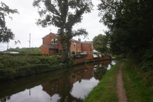
Arnold's Wood is a picturesque forest located in Warwickshire, England. Spread over an area of approximately 100 acres, this woodland is known for its stunning natural beauty and diverse ecosystem. The wood is named after Sir Thomas Arnold, a prominent local figure, who was instrumental in preserving and developing the area for public enjoyment.

Arnold's Wood is home to a wide variety of plant and animal species, making it a popular destination for nature enthusiasts and wildlife photographers. The forest boasts an enchanting mix of deciduous and coniferous trees, creating a vibrant and colorful landscape throughout the year. Visitors can expect to see oak, beech, ash, and pine trees, among others.

The wood offers a network of well-maintained trails, allowing visitors to explore its hidden treasures at their own pace. These trails wind through the forest, offering breathtaking views of the surrounding countryside and glimpses of wildlife. Birdwatching is particularly popular in Arnold's Wood, with species such as woodpeckers, owls, and songbirds frequently spotted.

In addition to its natural wonders, Arnold's Wood also provides recreational facilities for visitors. There are picnic areas, where families and friends can relax and enjoy a meal amidst the tranquil surroundings. The wood also has designated areas for camping and barbecues, allowing visitors to extend their stay and immerse themselves fully in the forest experience.

Overall, Arnold's Wood is a cherished destination for those seeking a peaceful retreat in nature. Its rich biodiversity, scenic trails, and recreational amenities make it a must-visit location in Warwickshire for locals and tourists alike.

If you have any feedback on the listing, please let us know in the comments section below.

Arnold's Wood Images

Images are sourced within 2km of 52.353458/-1.8064613 or Grid Reference SP1372. Thanks to Geograph Open Source API. All images are credited.

Church of St Thomas
Church of St Thomas
Stratford-upon-Avon Canal at Wharf Tavern
Wharf Tavern, Hockley Heath
Canal boat Pegasus, Stratford-upon-Avon Canal
Canal boat Lazy Otter, Stratford-upon-Avon Canal
Stratford-upon-Avon Canal towards bridge #24
Stratford-upon-Avon Canal at Saddlerswell Lane Bridge,  bridge #24
Stratford-upon-Avon Canal at Saddlerswell Lane Bridge, bridge #24
Stratford-upon-Avon Canal towards bridge #23
Stratford-upon-Avon Canal at Ashford Lane Bridge,  bridge #23
Stratford-upon-Avon Canal at Ashford Lane Bridge, bridge #23
Stratford-upon-Avon Canal at Ashford Lane Bridge,  bridge #23
Stratford-upon-Avon Canal at Ashford Lane Bridge, bridge #23
Stratford-upon-Avon Canal towards bridge #22
Stratford-upon-Avon Canal at Rotherhams Oak Bridge, bridge #22
Stratford-upon-Avon Canal towards bridge #21
Stratford-upon-Avon Canal at Tinkers Lane Bridge, bridge #21
Stratford-upon-Avon Canal towards bridge #20A
Show me another place!

Arnold's Wood is located at Grid Ref: SP1372 (Lat: 52.353458, Lng: -1.8064613)

Administrative County: Warwickshire

District: Stratford-on-Avon

Police Authority: Warwickshire

What 3 Words

///paying.feel.pool. Near Hockley Heath, West Midlands

Nearby Locations

Arnold's Wood Chalcot Wood

Related Wikis

RAF Hockley Heath

RAF Hockley Heath is a former Royal Air Force station located 4 miles (6.4 km) south of Solihull, Warwickshire, England, 7.7 miles (12.4 km) north-east...

Umberslade Hall

Umberslade Hall is a 17th-century mansion converted into residential apartments situated in Nuthurst near Tanworth-in-Arden, Warwickshire. It is a Grade...

Umberslade Baptist Church

Umberslade Baptist Church is a redundant Baptist church southwest of the village of Hockley Heath, Solihull, West Midlands, England (grid reference SP147721...
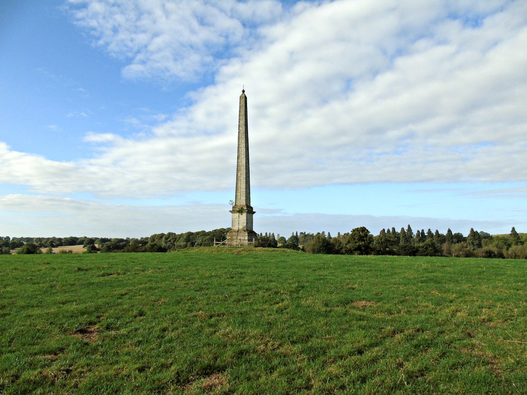
Umberslade Obelisk

The Umberslade Obelisk is a Grade II listed monument in Warwickshire, England constructed by order of Thomas Archer, 1st Baron Archer, on his estate of...

Nearby Amenities

Located within 500m of 52.353458,-1.8064613
Bus Stop
Rotherhams Oak L
Bus: yes
Naptan AtcoCode: 4200F122921
Naptan Bearing: W
Naptan CommonName: Rotherhams Oak L
Naptan Indicator: Opp
Naptan NaptanCode: warajtag
Naptan Street: Cut Throat Lane
Naptan Verified: no
Public Transport: platform
Source: naptan_import
Lat/Long: 52.3544174/-1.8008725
Bus Stop
Rotherhams Oak Lane
Bus: yes
Naptan AtcoCode: 4200F122922
Naptan Bearing: E
Naptan CommonName: Rotherhams Oak Lane
Naptan Indicator: Adj
Naptan NaptanCode: warapwjt
Naptan Street: Cut Throat Lane
Naptan Verified: no
Public Transport: platform
Source: naptan_import
Lat/Long: 52.3545521/-1.8007985
Phone
Check Date: 2022-03-22
Emergency: phone
Source: survey
Lat/Long: 52.3513239/-1.8100656
Phone
Check Date: 2022-03-30
Emergency: phone
Source: survey
Lat/Long: 52.3514093/-1.8087862
Motorway Junction
Umberslade Interchange
Destination: M40 London, Warwick, Stratford
Exit To: M40 London, Warwick, Stratford
Ref: 3A
Lat/Long: 52.3559118/-1.8081449
ShortDescription: M42/6296A M42 northBound
Bcc Ref: 30084641
Operator: National Highways
Operator Wikidata: Q5760006
Ref: M42/6296A
Source: bcc
Traffic Sign: variable_message
Traffic Sign Location: overhead
Variable Message Information: traffic
Lat/Long: 52.3530662/-1.8094105
Man Made: mast
Tower Type: communication
Lat/Long: 52.3566171/-1.8082944
Power: pole
Source: bing
Lat/Long: 52.3570947/-1.8090722
Material: wood
Power: pole
Ref: 720387
Source: wpd_open_data
Transformer: distribution
Lat/Long: 52.3565451/-1.8088415
Man Made: tower
Source: Warwicks Aerial Imagery
Tower Type: telecom
Lat/Long: 52.3564206/-1.808808
Material: wood
Power: pole
Source: bing
Lat/Long: 52.3577819/-1.8058804
Power: pole
Source: bing
Lat/Long: 52.356953/-1.8061124
Power: pole
Ref: 720398
Source: wpd_open_data
Transformer: distribution
Lat/Long: 52.3563903/-1.80674
Man Made: tower
Source: Warwicks Aerial Imagery
Tower Type: telecom
Lat/Long: 52.3562764/-1.8068916
The data included in this document is from www.openstreetmap.org. The data is made available under ODbL.

Have you been to Arnold's Wood?

Leave your review of Arnold's Wood below (or comments, questions and feedback).