Black Fir Wood

Wood, Forest in Staffordshire Lichfield

England

Black Fir Wood

View down the Old London Road The new London Road, the A38 dual carriageway runs parallel with this road, behind the trees on the left. This is looking Northwards towards Lichfield.
View down the Old London Road Credit: Mick Malpass

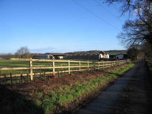
Black Fir Wood is a beautiful forest located in Staffordshire, England. Spanning over a vast area of land, this woodland is known for its dense growth of fir trees, which give it its distinctive name. The forest is situated within the Cannock Chase Area of Outstanding Natural Beauty, attracting nature enthusiasts and outdoor lovers alike.

Black Fir Wood is home to a wide variety of flora and fauna, making it an important habitat for various species. The towering fir trees create a stunning canopy, allowing only dappled sunlight to filter through to the forest floor. This creates a unique and enchanting atmosphere, perfect for those seeking tranquility and a connection with nature.

The forest provides numerous opportunities for outdoor activities and exploration. There are several well-maintained walking trails, allowing visitors to meander through the woodland and marvel at the diverse plant life and wildlife. Birdwatchers will be delighted by the presence of various avian species, including woodpeckers, owls, and buzzards.

In addition to its natural beauty, Black Fir Wood has historical significance. The area was once part of the ancient royal hunting ground of Cannock Chase and has been used for timber production over the centuries. Today, the woodland is managed by local authorities to preserve its natural integrity and protect its unique ecosystem.

Visitors to Black Fir Wood can enjoy a picnic amidst the serene surroundings or simply relax and take in the peaceful ambiance. The forest offers a welcome respite from the hustle and bustle of everyday life, allowing visitors to reconnect with nature and find solace in its beauty.

If you have any feedback on the listing, please let us know in the comments section below.

Black Fir Wood Images

Images are sourced within 2km of 52.611632/-1.8068181 or Grid Reference SK1301. Thanks to Geograph Open Source API. All images are credited.

View down the Old London Road The new London Road, the A38 dual carriageway runs parallel with this road, behind the trees on the left. This is looking Northwards towards Lichfield.
View down the Old London Road
The new London Road, the A38 dual carriageway runs parallel with this road, behind the trees on the left. This is looking Northwards towards Lichfield.
The M6 Toll
The M6 Toll
M6 Toll southbound 1 mile from Junction T3
M6 Toll Road near Roughley The M6 Toll Road is a 27-mile private-sector expressway to the north of Birmingham. The M6 is the key artery through the West Midlands, but it suffers from chronic congestion as part of Britain’s longest and most important motorway. The Birmingham Northern Relief Road, as the M6 Toll was originally known, was built to siphon off the through traffic between the South-east and the North-West.

Site clearance started in 2000, construction of the road began in 2002 and it opened in December 2003 (<span class="nowrap"><a title="http://www.m6toll.co.uk/about-us/history/" rel="nofollow ugc noopener" href="http://www.m6toll.co.uk/about-us/history/">Link</a><img style="margin-left:2px;" alt="External link" title="External link - shift click to open in new window" src="https://s1.geograph.org.uk/img/external.png" width="10" height="10"/></span>  M6 Toll History). When planned, it was forecast that 72000 vehicles would use the link, but just half that number of motorists take the route today (2013 - <span class="nowrap"><a title="http://www.independent.co.uk/news/uk/home-news/overpriced-and-underused-m6-toll-road-is-going-nowhere-fast-8606755.html" rel="nofollow ugc noopener" href="http://www.independent.co.uk/news/uk/home-news/overpriced-and-underused-m6-toll-road-is-going-nowhere-fast-8606755.html">Link</a><img style="margin-left:2px;" alt="External link" title="External link - shift click to open in new window" src="https://s1.geograph.org.uk/img/external.png" width="10" height="10"/></span>  Overpriced and underused – The Independent) whilst in contrast, the M6 itself is still carrying in excess of 125,000 vehicles a day with many claiming that the toll route’s benefits do not warrant the charges (2013 rates: currently £5.50 for private cars and £11 for trucks, with modest discounts for weekend and overnight use - see <a href="https://www.geograph.org.uk/photo/3665133">SP2685 : M6 Toll Tariff, Chapel Green</a>) and that when traffic is flowing reasonably freely on the original M6, there is no incentive to use the toll route which is marginally longer than the free motorway, with time also lost for stopping to pay at the toll booth.

The toll motorway is operated by Midland Expressway Ltd, which has the concession until 2054 – when the road is due to be handed back to the government.
M6 Toll Road near Roughley
The M6 Toll Road is a 27-mile private-sector expressway to the north of Birmingham. The M6 is the key artery through the West Midlands, but it suffers from chronic congestion as part of Britain’s longest and most important motorway. The Birmingham Northern Relief Road, as the M6 Toll was originally known, was built to siphon off the through traffic between the South-east and the North-West. Site clearance started in 2000, construction of the road began in 2002 and it opened in December 2003 (LinkExternal link M6 Toll History). When planned, it was forecast that 72000 vehicles would use the link, but just half that number of motorists take the route today (2013 - LinkExternal link Overpriced and underused – The Independent) whilst in contrast, the M6 itself is still carrying in excess of 125,000 vehicles a day with many claiming that the toll route’s benefits do not warrant the charges (2013 rates: currently £5.50 for private cars and £11 for trucks, with modest discounts for weekend and overnight use - see SP2685 : M6 Toll Tariff, Chapel Green) and that when traffic is flowing reasonably freely on the original M6, there is no incentive to use the toll route which is marginally longer than the free motorway, with time also lost for stopping to pay at the toll booth. The toll motorway is operated by Midland Expressway Ltd, which has the concession until 2054 – when the road is due to be handed back to the government.
M6 Toll northbound, Roughley
Little Hay Mission Church Becoming something of a rarity, this small mission church is a good example of the few remaining tin churches in Britain. Little Hay is just to the west of the M6 toll road.
Little Hay Mission Church
Becoming something of a rarity, this small mission church is a good example of the few remaining tin churches in Britain. Little Hay is just to the west of the M6 toll road.
Canwell churchyard
Canwell churchyard
A38 at Canwell Looking north from the tarmac that used to be the A446. A bridge over the M6 Toll is visible through a gap in the hedge on the left.
A38 at Canwell
Looking north from the tarmac that used to be the A446. A bridge over the M6 Toll is visible through a gap in the hedge on the left.
M6 main toll booths The main toll booths on the southbound M6 Toll Road
M6 main toll booths
The main toll booths on the southbound M6 Toll Road
Little Hay waterworks
Rookery Farm The Heart of England Way passes between the buildings of this farm. There is very little sound of traffic here as the farm is quite distant from any roads.
Rookery Farm
The Heart of England Way passes between the buildings of this farm. There is very little sound of traffic here as the farm is quite distant from any roads.
M6 Toll at Weeford
M6 Toll at Weeford
Manorial Farm Hillwood Road, Sutton Coldfield One of the few remaining farms in the vicinity of Sutton Coldfield.
Manorial Farm Hillwood Road, Sutton Coldfield
One of the few remaining farms in the vicinity of Sutton Coldfield.
Oak Farm Green Barns Lane, Weeford Picture shows newly erected stables.
Oak Farm Green Barns Lane, Weeford
Picture shows newly erected stables.
Little Hay Pumping Station South Staffordshire Waterworks Company pumping station built in 1929.
Little Hay Pumping Station
South Staffordshire Waterworks Company pumping station built in 1929.
Manley Lodge A mixture of different architectural styles are present on the extensions to the lodge.
Manley Lodge
A mixture of different architectural styles are present on the extensions to the lodge.
Old entrance to Thickbroom Farm A narrow bridge over the Black Brook leads up to the farm.
Old entrance to Thickbroom Farm
A narrow bridge over the Black Brook leads up to the farm.
Black Brook Otter country? Provision has been made on the new bridges downstream of here with otter ledges.
Black Brook
Otter country? Provision has been made on the new bridges downstream of here with otter ledges.
Show me another place!

Black Fir Wood is located at Grid Ref: SK1301 (Lat: 52.611632, Lng: -1.8068181)

Administrative County: Staffordshire

District: Lichfield

Police Authority: Staffordshire

What 3 Words

///punk.tower.heat. Near Shenstone, Staffordshire

Nearby Locations

Black Fir Wood Green Wood

Related Wikis

Roughley

Roughley is an electoral ward within the Royal Town of Sutton Coldfield, and is the most northerly part of the administrative area covered by the Royal...

Manley Hall, Staffordshire

Manley Hall (also known as Thickbroom Hall) was an English Tudor-style country house in Weeford, near Lichfield in Staffordshire. The house was built in...

Sutton Coldfield transmitting station

The Sutton Coldfield transmitting station is a broadcasting and telecommunications facility located in Sutton Coldfield, Birmingham, England. In terms...

Weeford

Weeford is a village and civil parish in the Lichfield district of Staffordshire, England. According to the 2011 Census, the parish had a population of...

Shenstone Lodge School

Shenstone Lodge School is a residential special school for children with behaviour or emotional difficulties, in Shenstone, Staffordshire, England, between...

Blake Street railway station

Blake Street railway station serves the Hill Hook area of Sutton Coldfield, Birmingham, England. It is situated on the Cross-City Line, located on the...

St James' Church, Mere Green

St James’ Church is a Grade II listed Church of England parish church in Mere Green, Sutton Coldfield, England. == History == It was founded as a daughter...

Sutton Four Oaks (ward)

Sutton Four Oaks is one of the 40 electoral wards in Birmingham, England.Sutton Four Oaks is one of the four wards that make up the Parliamentary Constituency...

Nearby Amenities

Located within 500m of 52.611632,-1.8068181
Power: tower
Lat/Long: 52.6137707/-1.8060836
Power: tower
Lat/Long: 52.6137552/-1.801137
Power: tower
Lat/Long: 52.6137714/-1.8119026
The data included in this document is from www.openstreetmap.org. The data is made available under ODbL.

Have you been to Black Fir Wood?

Leave your review of Black Fir Wood below (or comments, questions and feedback).