Ash Covert
Wood, Forest in Gloucestershire Cotswold
England
Ash Covert
Ash Covert is a picturesque area located in Gloucestershire, England. Situated in the heart of the Forest of Dean, it is known for its dense woodlands and tranquil surroundings. The name "Ash Covert" refers to the abundance of ash trees that populate the region, adding to its natural beauty.
Covering an area of approximately [insert size], Ash Covert is a haven for nature lovers and outdoor enthusiasts. The forest is home to a diverse range of flora and fauna, including rare species such as the wild boar and various bird species. The rich biodiversity of the area makes it an ideal spot for wildlife observation and nature walks.
Visitors to Ash Covert can explore the numerous walking trails that wind through the forest and take in the stunning scenery. The forest offers a peaceful and serene atmosphere, providing an escape from the hustle and bustle of everyday life. It is also a popular destination for camping and picnicking, with designated areas available for visitors to enjoy the outdoors.
In addition to its natural beauty, Ash Covert is steeped in history. The forest has been utilized for centuries, with evidence of human settlement dating back to prehistoric times. The area has witnessed various historical events, including the industrialization period when it served as a source of timber for the local economy.
Overall, Ash Covert in Gloucestershire is a captivating destination that combines natural splendor with a rich historical heritage. Its woodlands, wildlife, and serene atmosphere make it an idyllic retreat for those seeking solace in nature.
If you have any feedback on the listing, please let us know in the comments section below.
Ash Covert Images
Images are sourced within 2km of 51.804095/-1.8411028 or Grid Reference SP1111. Thanks to Geograph Open Source API. All images are credited.
![A walk around the Fosse Way [12] A view from the bridleway across the fields to Greenhill Covert.
Starting at Fossebridge, where the Fosse Way descends precipitously to cross the River Coln, the walk gently ascends on a road and then a bridleway to meet a minor road which is part of the Salt Way. After using the Salt Way to cross the Fosse Way the route descends on footpaths and minor roads via Oxpens Farm and Stowell Mill to return to Fossebridge.](https://s1.geograph.org.uk/geophotos/06/99/59/6995953_2206fe48.jpg)
![A walk around the Fosse Way [14] The track, a bridleway, ascends gently as it heads northeast.
Starting at Fossebridge, where the Fosse Way descends precipitously to cross the River Coln, the walk gently ascends on a road and then a bridleway to meet a minor road which is part of the Salt Way. After using the Salt Way to cross the Fosse Way the route descends on footpaths and minor roads via Oxpens Farm and Stowell Mill to return to Fossebridge.](https://s0.geograph.org.uk/geophotos/06/99/59/6995960_7c495eff.jpg)
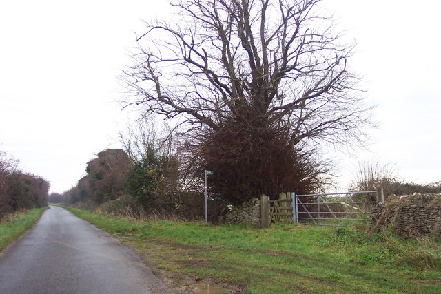
![A walk around the Fosse Way [15] On the edge of Fox Covert, this shed is slowly being reclaimed by the undergrowth. Seen from the bridleway.
Starting at Fossebridge, where the Fosse Way descends precipitously to cross the River Coln, the walk gently ascends on a road and then a bridleway to meet a minor road which is part of the Salt Way. After using the Salt Way to cross the Fosse Way the route descends on footpaths and minor roads via Oxpens Farm and Stowell Mill to return to Fossebridge.](https://s2.geograph.org.uk/geophotos/06/99/59/6995962_2ad354f2.jpg)
![A walk around the Fosse Way [16] A strange structure at the side of the bridleway. Sown as a tank on OS maps.
Starting at Fossebridge, where the Fosse Way descends precipitously to cross the River Coln, the walk gently ascends on a road and then a bridleway to meet a minor road which is part of the Salt Way. After using the Salt Way to cross the Fosse Way the route descends on footpaths and minor roads via Oxpens Farm and Stowell Mill to return to Fossebridge.](https://s2.geograph.org.uk/geophotos/06/99/59/6995966_c3cb0644.jpg)
![A walk around the Fosse Way [17] A rough track runs along the edge of Fox Covert. Seen from the bridleway.
Starting at Fossebridge, where the Fosse Way descends precipitously to cross the River Coln, the walk gently ascends on a road and then a bridleway to meet a minor road which is part of the Salt Way. After using the Salt Way to cross the Fosse Way the route descends on footpaths and minor roads via Oxpens Farm and Stowell Mill to return to Fossebridge.](https://s0.geograph.org.uk/geophotos/06/99/59/6995968_190f210a.jpg)
![A walk around the Fosse Way [18] The bridleway now traverses open fields full of ripening crops.
Starting at Fossebridge, where the Fosse Way descends precipitously to cross the River Coln, the walk gently ascends on a road and then a bridleway to meet a minor road which is part of the Salt Way. After using the Salt Way to cross the Fosse Way the route descends on footpaths and minor roads via Oxpens Farm and Stowell Mill to return to Fossebridge.](https://s1.geograph.org.uk/geophotos/06/99/59/6995969_a0ce1894.jpg)
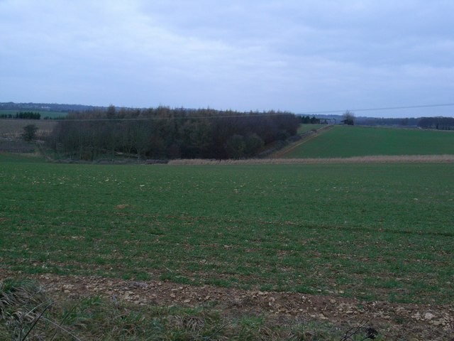
![A walk around the Fosse Way [19] From the bridleway a view across the fields with The Far Covert in the distance.
Starting at Fossebridge, where the Fosse Way descends precipitously to cross the River Coln, the walk gently ascends on a road and then a bridleway to meet a minor road which is part of the Salt Way. After using the Salt Way to cross the Fosse Way the route descends on footpaths and minor roads via Oxpens Farm and Stowell Mill to return to Fossebridge.](https://s2.geograph.org.uk/geophotos/06/99/59/6995970_a34116ff.jpg)
![A walk around the Fosse Way [20] From the bridleway a view across the fields with Home Covert in the far distance.
Starting at Fossebridge, where the Fosse Way descends precipitously to cross the River Coln, the walk gently ascends on a road and then a bridleway to meet a minor road which is part of the Salt Way. After using the Salt Way to cross the Fosse Way the route descends on footpaths and minor roads via Oxpens Farm and Stowell Mill to return to Fossebridge.](https://s3.geograph.org.uk/geophotos/06/99/59/6995971_edb62513.jpg)
![A walk around the Fosse Way [21] An oil pipeline crosses the bridleway.
Starting at Fossebridge, where the Fosse Way descends precipitously to cross the River Coln, the walk gently ascends on a road and then a bridleway to meet a minor road which is part of the Salt Way. After using the Salt Way to cross the Fosse Way the route descends on footpaths and minor roads via Oxpens Farm and Stowell Mill to return to Fossebridge.](https://s0.geograph.org.uk/geophotos/06/99/59/6995972_8b60af7b.jpg)
![A walk around the Fosse Way [22] Seen from the bridleway is Saltway Barn, now converted into a private residence. The barn is late 18th century in rubble stone with dressed quoins, under a stone slate roof. The eight-bay open-fronted cart store at right angles to the barn has also been converted into domestic use. Listed, grade II, with details at: <span class="nowrap"><a title="https://historicengland.org.uk/listing/the-list/list-entry/1090228" rel="nofollow ugc noopener" href="https://historicengland.org.uk/listing/the-list/list-entry/1090228">Link</a><img style="margin-left:2px;" alt="External link" title="External link - shift click to open in new window" src="https://s1.geograph.org.uk/img/external.png" width="10" height="10"/></span>
Starting at Fossebridge, where the Fosse Way descends precipitously to cross the River Coln, the walk gently ascends on a road and then a bridleway to meet a minor road which is part of the Salt Way. After using the Salt Way to cross the Fosse Way the route descends on footpaths and minor roads via Oxpens Farm and Stowell Mill to return to Fossebridge.](https://s1.geograph.org.uk/geophotos/06/99/59/6995973_1ef70d18.jpg)
![A walk around the Fosse Way [23] Seen from the bridleway is Saltway Barn, now converted into a private residence. The barn is late 18th century in rubble stone with dressed quoins, under a stone slate roof. The eight-bay open-fronted cart store at right angles to the barn has also been converted into domestic use. Listed, grade II, with details at: <span class="nowrap"><a title="https://historicengland.org.uk/listing/the-list/list-entry/1090228" rel="nofollow ugc noopener" href="https://historicengland.org.uk/listing/the-list/list-entry/1090228">Link</a><img style="margin-left:2px;" alt="External link" title="External link - shift click to open in new window" src="https://s1.geograph.org.uk/img/external.png" width="10" height="10"/></span>
Starting at Fossebridge, where the Fosse Way descends precipitously to cross the River Coln, the walk gently ascends on a road and then a bridleway to meet a minor road which is part of the Salt Way. After using the Salt Way to cross the Fosse Way the route descends on footpaths and minor roads via Oxpens Farm and Stowell Mill to return to Fossebridge.](https://s2.geograph.org.uk/geophotos/06/99/59/6995974_2dbc452f.jpg)
![A walk around the Fosse Way [24] From the minor road the bridleway leaves on its way to Coln St Dennis.
Starting at Fossebridge, where the Fosse Way descends precipitously to cross the River Coln, the walk gently ascends on a road and then a bridleway to meet a minor road which is part of the Salt Way. After using the Salt Way to cross the Fosse Way the route descends on footpaths and minor roads via Oxpens Farm and Stowell Mill to return to Fossebridge.](https://s0.geograph.org.uk/geophotos/06/99/60/6996012_cf79f6b9.jpg)
![A walk around the Fosse Way [25] The Salt Way is seen looking southeast from where the bridleway to Coln St Dennis starts to the right of the image.
The Salt Way is an old British trackway, which runs from Droitwich through Worcestershire, and into Gloucestershire near Ashton-under‑Hill. It then runs past Hawling, Salperton, and Hazleton to cross the Fosse Way between Northleach and Stowell Park. It then proceeds by Crickley Barrow to Coln St. Aldwyns, where it crosses Ikenild Street and leaves Gloucestershire at Lechlade on its way to the coast of Hampshire.
Starting at Fossebridge, where the Fosse Way descends precipitously to cross the River Coln, the walk gently ascends on a road and then a bridleway to meet a minor road which is part of the Salt Way. After using the Salt Way to cross the Fosse Way the route descends on footpaths and minor roads via Oxpens Farm and Stowell Mill to return to Fossebridge.](https://s0.geograph.org.uk/geophotos/06/99/60/6996016_f3186bd0.jpg)
![A walk around the Fosse Way [26] The Salt Way is seen looking northwest from where the bridleway to Coln St Dennis starts to the left of the image.
The Salt Way is an old British trackway, which runs from Droitwich through Worcestershire, and into Gloucestershire near Ashton-under‑Hill. It then runs past Hawling, Salperton, and Hazleton to cross the Fosse Way between Northleach and Stowell Park. It then proceeds by Crickley Barrow to Coln St. Aldwyns, where it crosses Ikenild Street and leaves Gloucestershire at Lechlade on its way to the coast of Hampshire.
Starting at Fossebridge, where the Fosse Way descends precipitously to cross the River Coln, the walk gently ascends on a road and then a bridleway to meet a minor road which is part of the Salt Way. After using the Salt Way to cross the Fosse Way the route descends on footpaths and minor roads via Oxpens Farm and Stowell Mill to return to Fossebridge.](https://s1.geograph.org.uk/geophotos/06/99/60/6996021_48dbd3ef.jpg)
![A walk around the Fosse Way [27] The view from the Salt Way looking northeast.
The Salt Way is an old British trackway, which runs from Droitwich through Worcestershire, and into Gloucestershire near Ashton-under‑Hill. It then runs past Hawling, Salperton, and Hazleton to cross the Fosse Way between Northleach and Stowell Park. It then proceeds by Crickley Barrow to Coln St. Aldwyns, where it crosses Ikenild Street and leaves Gloucestershire at Lechlade on its way to the coast of Hampshire.
Starting at Fossebridge, where the Fosse Way descends precipitously to cross the River Coln, the walk gently ascends on a road and then a bridleway to meet a minor road which is part of the Salt Way. After using the Salt Way to cross the Fosse Way the route descends on footpaths and minor roads via Oxpens Farm and Stowell Mill to return to Fossebridge.](https://s2.geograph.org.uk/geophotos/06/99/66/6996686_ccf66890.jpg)
![A walk around the Fosse Way [28] The Far Peak entrance, seen from the minor road that is the Salt Way. Far Peak offers a climbing gym and a campsite amongst other facilities.
The Salt Way is an old British trackway, which runs from Droitwich through Worcestershire, and into Gloucestershire near Ashton-under‑Hill. It then runs past Hawling, Salperton, and Hazleton to cross the Fosse Way between Northleach and Stowell Park. It then proceeds by Crickley Barrow to Coln St. Aldwyns, where it crosses Ikenild Street and leaves Gloucestershire at Lechlade on its way to the coast of Hampshire.
Starting at Fossebridge, where the Fosse Way descends precipitously to cross the River Coln, the walk gently ascends on a road and then a bridleway to meet a minor road which is part of the Salt Way. After using the Salt Way to cross the Fosse Way the route descends on footpaths and minor roads via Oxpens Farm and Stowell Mill to return to Fossebridge.](https://s3.geograph.org.uk/geophotos/06/99/66/6996687_297b4257.jpg)
Ash Covert is located at Grid Ref: SP1111 (Lat: 51.804095, Lng: -1.8411028)
Administrative County: Gloucestershire
District: Cotswold
Police Authority: Gloucestershire
What 3 Words
///easygoing.accented.head. Near Northleach, Gloucestershire
Nearby Locations
Related Wikis

Coln St. Dennis
Coln St. Dennis is a village and civil parish on the River Coln in Gloucestershire about 3 miles (4.8 km) southwest of Northleach and about 7 miles (11...

Eastington, Cotswold
Eastington is a hamlet and former civil parish, now in the parish of Northleach with Eastington, in the Cotswold district, in the English county of Gloucestershire...
Northleach with Eastington
Northleach with Eastington is a civil parish in the English county of Gloucestershire that includes the town of Northleach and the hamlet of Eastington...

Calcot, Gloucestershire
Calcot is a settlement in the English county of Gloucestershire. Calcot forms part of the civil parish of Coln St Dennis, within the Cotswold local government...

RAF Bibury
Royal Air Force Bibury or more simply RAF Bibury is a former Royal Air Force satellite station located north east of Cirencester, Gloucestershire, England...

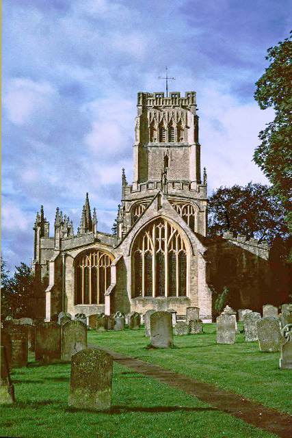
Church of St James, Coln St. Dennis
The Anglican Church of St James at Coln St. Dennis in the Cotswold District of Gloucestershire, England was built in the 12th century. It is a grade I...
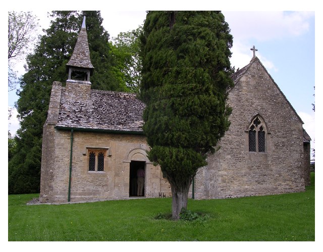
Church of St Leonard, Stowell Park
The Anglican Church of St Leonard at Stowell Park, in the Cotswold District of Gloucestershire, England was built in the 12th century. It is a grade I...
Northleach
Northleach is a market town and former civil parish, now in parish Northleach with Eastington, in the Cotswold district, in Gloucestershire, England. The...
Nearby Amenities
Located within 500m of 51.804095,-1.8411028Have you been to Ash Covert?
Leave your review of Ash Covert below (or comments, questions and feedback).