Panorama Woods

Wood, Forest in Yorkshire

England

Panorama Woods

Broken down wall, E of Piper's Crag, Rombalds Moor
Broken down wall, E of Piper's Crag, Rombalds Moor Credit: Colin Park

Panorama Woods, located in Yorkshire, is a picturesque woodland area that captivates visitors with its natural beauty and serene atmosphere. Covering a vast expanse, the woods offer a diverse range of flora and fauna, making it a haven for nature enthusiasts and outdoor enthusiasts alike.

The woodland is characterized by its dense canopy of trees, predominantly consisting of oak, beech, and birch trees. The towering trees create a cool and shaded environment, perfect for leisurely walks and exploration. Throughout the woods, a network of well-maintained trails weaves through the landscape, providing visitors with easy access to the various areas of interest.

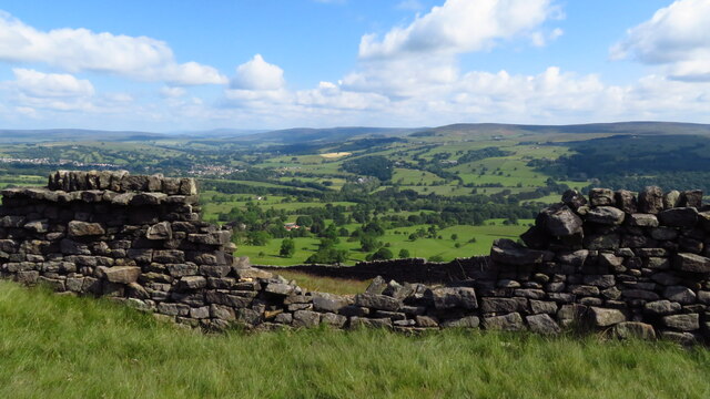
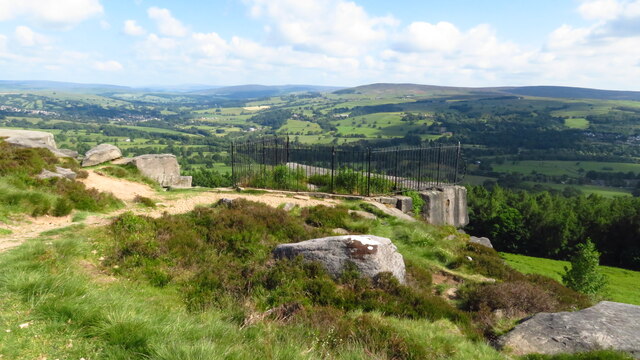
One of the main attractions in Panorama Woods is its panoramic views. As the name suggests, the woods offer breathtaking vistas of the surrounding countryside, with rolling hills and meandering rivers visible from certain vantage points. These captivating views make Panorama Woods a popular spot for photographers and nature lovers seeking a tranquil escape.

Moreover, Panorama Woods is home to a diverse array of wildlife. Visitors may encounter numerous species of birds, including woodpeckers, owls, and songbirds, as well as mammals such as deer and squirrels. The woods also support a rich variety of plant life, with carpets of wildflowers adding bursts of color to the landscape during the spring and summer months.

Overall, Panorama Woods in Yorkshire is a haven of natural beauty, offering visitors a chance to immerse themselves in the tranquility of its woodlands, enjoy breathtaking views, and appreciate the diverse wildlife that calls this area home.

If you have any feedback on the listing, please let us know in the comments section below.

Panorama Woods Images

Images are sourced within 2km of 53.919877/-1.8441564 or Grid Reference SE1047. Thanks to Geograph Open Source API. All images are credited.

Broken down wall, E of Piper's Crag, Rombalds Moor
Swastika Stone (close up) Rombalds Moor
Swastika Stone Rombalds Moor
Heber's Ghyll Footbridge View up the path with several footbridges crossing the beck
Heber's Ghyll Footbridge
View up the path with several footbridges crossing the beck
Footpath and bridge in Heber's Ghyll A walk up onto Ilkley Moor.
Footpath and bridge in Heber's Ghyll
A walk up onto Ilkley Moor.
The Sepulchre Stone Alongside the Dales High Way.
The Sepulchre Stone
Alongside the Dales High Way.
Hebers Ghyll, Ilkley August 2023
Old Milestone by the A65, Skipton Road, Ilkley Milestone by the A65, in parish of Ilkley (Leeds District), Skipton Road, on verge near lamppost LP279, 100m to '40' sign.

Inscription reads:-
: BOLTON / BRIDGE / 4 MILES / SKIPTON / 8 MILES : : SKIPTON & OTLEY / ROAD / ILKLEY : : ILKLEY / 1½ MILES / OTLEY / 7¼ MILES : 

Grade II listed.
List Entry Number: 1393128 <span class="nowrap"><a title="https://historicengland.org.uk/listing/the-list/list-entry/1393128" rel="nofollow ugc noopener" href="https://historicengland.org.uk/listing/the-list/list-entry/1393128">Link</a><img style="margin-left:2px;" alt="External link" title="External link - shift click to open in new window" src="https://s1.geograph.org.uk/img/external.png" width="10" height="10"/></span>

Milestone Society National ID: YW_SKOT08
Old Milestone by the A65, Skipton Road, Ilkley
Milestone by the A65, in parish of Ilkley (Leeds District), Skipton Road, on verge near lamppost LP279, 100m to '40' sign. Inscription reads:- : BOLTON / BRIDGE / 4 MILES / SKIPTON / 8 MILES : : SKIPTON & OTLEY / ROAD / ILKLEY : : ILKLEY / 1½ MILES / OTLEY / 7¼ MILES : Grade II listed. List Entry Number: 1393128 LinkExternal link Milestone Society National ID: YW_SKOT08
Shooting Butts on Whetstone Allotment The butts appeared to be a line of individual wooden panels
Shooting Butts on Whetstone Allotment
The butts appeared to be a line of individual wooden panels
Heber's Ghyll View up the boulder strewn stream to the top footbridge
Heber's Ghyll
View up the boulder strewn stream to the top footbridge
Snowy rocks on Ilkley Moor The first snow of the season had fallen on 29 November.
Snowy rocks on Ilkley Moor
The first snow of the season had fallen on 29 November.
Footbridge over Heber's Ghyll On a footpath along the bottom of Ilkley Moor.
Footbridge over Heber's Ghyll
On a footpath along the bottom of Ilkley Moor.
Looking down Heber's Ghyll From a footbridge <a href="https://www.geograph.org.uk/photo/7664749">SE0946 : Footbridge over Heber's Ghyll</a>.
Looking down Heber's Ghyll
Gate into Heber's Ghyll woodland
View up Wharfedale from Woodhouse Crag Cold weather gave a good view, including (front right to back left) Simon's Seat, Great Whernside and Buckden Pike.
View up Wharfedale from Woodhouse Crag
Cold weather gave a good view, including (front right to back left) Simon's Seat, Great Whernside and Buckden Pike.
Railings round the Swastika Stone The stone is one of many with prehistoric carvings on the moor, but perhaps the best known. Scheduled Monument ref. 1012014.
Railings round the Swastika Stone
The stone is one of many with prehistoric carvings on the moor, but perhaps the best known. Scheduled Monument ref. 1012014.
Detail of the Swastika Stone The stone is one of many with prehistoric carvings on the moor, but perhaps the best known. Scheduled Monument ref. 1012014. This figure is described in the listing as 'a curvilinear carved figure of Swastika shape with ten cups fitted into the five curved arms'. I didn't realise until after looking at other photos of it later, that this is actually a 19th century replica rather than the original, see <a href="https://www.geograph.org.uk/photo/48282">SE0946 : Swastika Stone, Ilkley (reproduction)</a>. The figure has nothing to do with 20th century fascism, and is believed to have had ritual significance, perhaps connected with fertility.

For context, see <a href="https://www.geograph.org.uk/photo/7664760">SE0946 : Railings round the Swastika Stone</a>.
Detail of the Swastika Stone
The stone is one of many with prehistoric carvings on the moor, but perhaps the best known. Scheduled Monument ref. 1012014. This figure is described in the listing as 'a curvilinear carved figure of Swastika shape with ten cups fitted into the five curved arms'. I didn't realise until after looking at other photos of it later, that this is actually a 19th century replica rather than the original, see SE0946 : Swastika Stone, Ilkley (reproduction). The figure has nothing to do with 20th century fascism, and is believed to have had ritual significance, perhaps connected with fertility. For context, see SE0946 : Railings round the Swastika Stone.
Levelled area of Ilkley Moor An area about ten yards square has been levelled by a cut-and-fill operation. Its purpose is unclear, as there was no evidence of there having been a building on it.
Levelled area of Ilkley Moor
An area about ten yards square has been levelled by a cut-and-fill operation. Its purpose is unclear, as there was no evidence of there having been a building on it.
Show me another place!

Panorama Woods is located at Grid Ref: SE1047 (Lat: 53.919877, Lng: -1.8441564)

Division: West Riding

Unitary Authority: Bradford

Police Authority: West Yorkshire

What 3 Words

///showdown.crate.snowy. Near Ilkley, West Yorkshire

Related Wikis

Nebstone

The Nebstone is a notable rock found close to the Swastika Stone on the northern edge of Ilkley Moor in West Yorkshire, England. It has the appearance...

Heathcote, Ilkley

Heathcote is a Neoclassical-style villa in Ilkley, West Yorkshire, England. Designed by architect Edwin Lutyens, it was his first comprehensive use of...
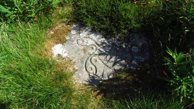
Swastika Stone

The Swastika Stone is a stone adorned with a design that resembles a swastika, located on the Woodhouse Crag on the northern edge of Ilkley Moor in West...
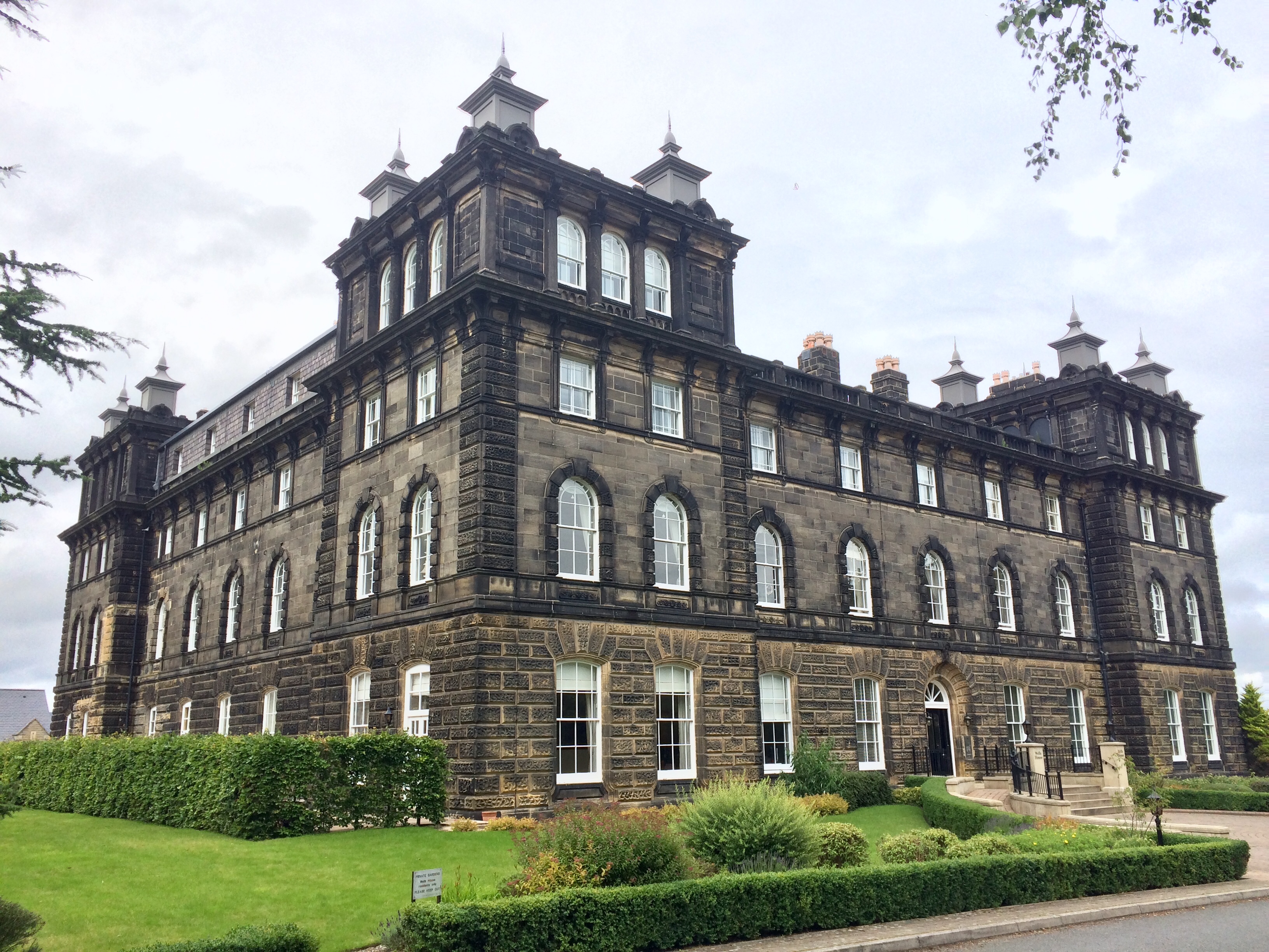
Wells House, Ilkley

Wells House is a large former hydropathic establishment and hotel in Ilkley, West Yorkshire, England, now used as private apartments. It was built in 1854...

Dales Way

The Dales Way is an 78.5-mile (126.3 km) long-distance footpath in Northern England, from (south-east to north-west) Ilkley, West Yorkshire, to Bowness...

Ilkley Golf Club

Ilkley Golf Club is a golf club in North Yorkshire, England, just outside the town of Ilkley in West Yorkshire. It is located about a mile to the northwest...

Christchurch, Ilkley

Christchurch, Ilkley is a Grade II listed United Reformed and Methodist ecumenical partnership church in Ilkley, North Yorkshire, England. == History... ==

Wharfedale Brewery

Wharfedale Brewery is a brewery situated in Ilkley in Wharfedale, West Yorkshire, England, on the edge of the Yorkshire Dales National Park. Two, now defunct...

Nearby Amenities

Located within 500m of 53.919877,-1.8441564
Created By: osmeditor2
Lat/Long: 53.9208098/-1.8465831
Created By: osmeditor2
Lat/Long: 53.9208723/-1.8471769
Created By: osmeditor2
Lat/Long: 53.9209035/-1.8477706
Created By: osmeditor2
Lat/Long: 53.9210285/-1.8483487
Created By: osmeditor2
Lat/Long: 53.9212082/-1.8487589
Is In: Ilkley
Postal Code: LS29
Lat/Long: 53.922645/-1.8397162
Bus Stop
Grove Road Hebers Ghyll Drive
Bench: no
Bin: no
Lit: yes
Local Ref: 45014143
Naptan AtcoCode: 450014143
Naptan Bearing: S
Naptan CommonName: Grove Road Hebers Ghyll Drive
Naptan Crossing: Hebers Ghyll Drive
Naptan Indicator: Stop 45014143
Naptan PlusbusZoneRef: LEEDS
Naptan ShortCommonName: Hebers Ghyll Drive
Naptan Street: Grove Road
Naptan Verified: no
Shelter: no
Source: naptan_import
Tactile Paving: no
Lat/Long: 53.923077/-1.8462473
Silver Well
Natural: spring
Source: OS 1851
Lat/Long: 53.9163829/-1.8422595
Intake Heads
Place: locality
Source: OS 1851
Lat/Long: 53.917571/-1.8407252
Panorama Stone
Fixme: What is this? Still there?
Source: OS 1851
Lat/Long: 53.9189355/-1.8435791
Bench
Lat/Long: 53.9180563/-1.8373906
Bench
Lat/Long: 53.9184322/-1.8439778
Bench
Lat/Long: 53.9184712/-1.8417052
Barrier: kissing_gate
Lat/Long: 53.9181844/-1.8507618
Bench
Backrest: yes
Lat/Long: 53.9230044/-1.8465348
Bench
Backrest: yes
Lat/Long: 53.9232332/-1.8437278
Man Made: flagpole
Lat/Long: 53.922784/-1.8462999
Bench
Backrest: yes
Lat/Long: 53.923916/-1.8422463
The data included in this document is from www.openstreetmap.org. The data is made available under ODbL.

Have you been to Panorama Woods?

Leave your review of Panorama Woods below (or comments, questions and feedback).