Arinacrinachd
Settlement in Ross-shire
Scotland
Arinacrinachd

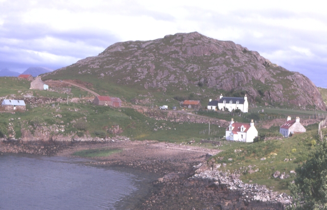
Arinacrinachd is a small village located in Ross-shire, a historic county in the Highlands of Scotland. Situated amidst stunning natural landscapes, the village is nestled on the eastern coast of Loch Carron, offering breathtaking views of the surrounding mountains and waters.
With a population of around 300 residents, Arinacrinachd maintains a close-knit community atmosphere. The village is renowned for its peaceful and idyllic setting, making it an attractive destination for nature enthusiasts and those seeking a tranquil retreat.
Although modest in size, Arinacrinachd offers a range of amenities to its residents and visitors. The village is home to a local primary school, a few quaint shops, and a welcoming community center that hosts various events and activities throughout the year. Additionally, there are several accommodation options available for tourists, including cozy bed and breakfasts and self-catering cottages.
Arinacrinachd is surrounded by an abundance of natural wonders, making it a paradise for outdoor enthusiasts. The nearby hills and mountains provide ample opportunities for hiking, mountain biking, and climbing, allowing visitors to immerse themselves in the beautiful Scottish wilderness. Loch Carron itself is a haven for water-based activities such as fishing, sailing, and kayaking.
For those interested in exploring further afield, Arinacrinachd serves as an ideal base for discovering the wider region of Ross-shire. Nearby attractions include the picturesque village of Plockton, the historic Eilean Donan Castle, and the dramatic landscapes of the Isle of Skye.
In summary, Arinacrinachd offers a serene and scenic escape in the heart of Ross-shire, providing a perfect blend of natural beauty, community spirit, and outdoor adventure.
If you have any feedback on the listing, please let us know in the comments section below.
Arinacrinachd Images
Images are sourced within 2km of 57.557579/-5.772577 or Grid Reference NG7458. Thanks to Geograph Open Source API. All images are credited.
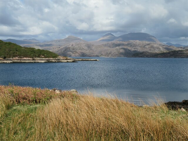
![Towards the coast at Fearnbeg Moorland leads towards a steep drop down to the entrance to Loch Torridon, on the far side of which, a line of houses can be seen at Lower Diabaig and with the mountains [L-R] of Baosbheinn, An Ruad-mheallan, and the double Munro of Beinn Alligin to the right.](https://s1.geograph.org.uk/geophotos/07/49/54/7495477_15476171.jpg)
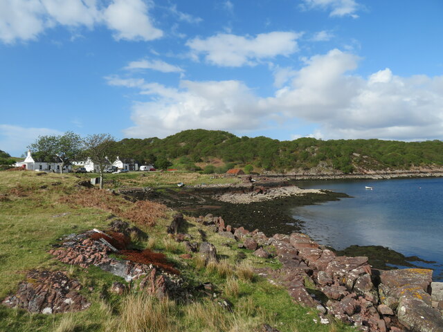
![Shed and boat, Kenmore Rusty 'tin' structures are common in the western Highlands and seem to add something to the scene, which here extends across the wooded headland to the distant slopes of Sgurr Mhor [left] and Tom na Gruagaich [right] which form the twin summits and Munros of Beinn Alligin.](https://s3.geograph.org.uk/geophotos/07/49/56/7495659_328ed684.jpg)


Arinacrinachd is located at Grid Ref: NG7458 (Lat: 57.557579, Lng: -5.772577)
Unitary Authority: Highland
Police Authority: Highlands and Islands
What 3 Words
///moats.year.inspected. Near Gairloch, Highland
Nearby Locations
Related Wikis

Loch Torridon
Loch Torridon (Scottish Gaelic: Loch Thoirbheartan) is a sea loch on the west coast of Scotland in the Northwest Highlands. The loch was created by glacial...
Ardheslaig
Ardheslaig (Scottish Gaelic: Àird Heisleag) is a crofting settlement at the northern end of the Applecross peninsula in the Scottish Highlands. It is 3...
Diabaig
Diabaig (Scottish Gaelic: Dìobaig) is a remote coastal fishing and crofting township in Wester Ross, in the Northwest Highlands of Scotland. Diabaig lies...
Shieldaig
Shieldaig (Scottish Gaelic: Sìldeag; Old Norse: síld-vík, lit. 'herring bay') is a village in Wester Ross in the Northwest Highlands, in the Scottish council...

Inveralligin
Inveralligin (Scottish Gaelic: Inbhir Àiliginn) is a remote crofting township which lies on the north shore of Loch Torridon in Wester Ross and is in the...
Nearby Amenities
Located within 500m of 57.557579,-5.772577Have you been to Arinacrinachd?
Leave your review of Arinacrinachd below (or comments, questions and feedback).