Graves Coppice

Wood, Forest in Warwickshire Stratford-on-Avon

England

Graves Coppice

Alcester Road at the junction of the M42
Alcester Road at the junction of the M42 Credit: David Howard

Graves Coppice is a picturesque woodland area located in Warwickshire, England. Situated near the village of Gravesend, this forested landscape covers an area of approximately 200 acres. The site is managed by the local council and is open to the public throughout the year.

The woodland is predominantly composed of a variety of native tree species, including oak, birch, ash, and beech. These trees create a dense canopy, providing shade and shelter for a diverse range of wildlife. The forest floor is covered in a carpet of ferns, wildflowers, and mosses, adding to the natural beauty of the area.

Graves Coppice boasts several well-maintained walking trails, allowing visitors to explore the wood at their own pace. These trails offer stunning views of the surrounding countryside and are suitable for both leisurely strolls and more challenging hikes. Along the paths, informative signs provide visitors with interesting facts about the flora and fauna that can be found in the woodland.

The forest is home to a rich array of wildlife, including various bird species, squirrels, rabbits, and deer. Birdwatchers will have the opportunity to spot species such as woodpeckers, nuthatches, and jays among the treetops. Additionally, the forest is known for its vibrant butterfly population, with species like the common blue and orange tip frequently seen during the summer months.

Graves Coppice offers a tranquil and idyllic escape from the hustle and bustle of everyday life. Whether it be for a leisurely walk, birdwatching, or simply enjoying the beauty of nature, this forested area is a must-visit for nature enthusiasts and those seeking a peaceful retreat.

If you have any feedback on the listing, please let us know in the comments section below.

Graves Coppice Images

Images are sourced within 2km of 52.358203/-1.8712833 or Grid Reference SP0873. Thanks to Geograph Open Source API. All images are credited.

Alcester Road at the junction of the M42
Fulford Heath Golf Club, Tanner's Green
Forshaw Park Farm on Poolhead Lane
Tanners Green Lane at the A435, Alcester Road
Chapel Lane from Hill Lane
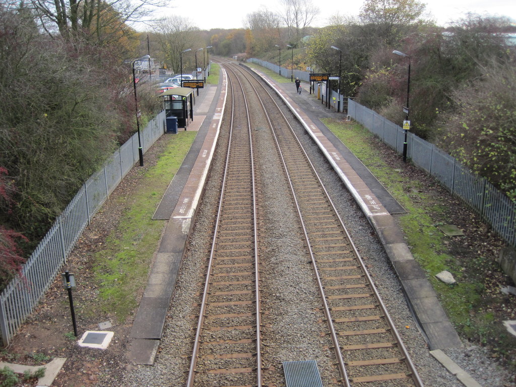
Earlswood station
Earlswood station
Old Milestone, A435, Wythall The milestone is located just south of the new Wythall roundabout, on the verge, on the east side of the road. Parish of Wythall (Bromsgrove District). Metal plate attached to concrete post, Bradley post design, erected by the County Council in the 20th century.

Inscription reads:-
A435 / ALCESTER 12. / 8 BIRMINGHAM. / C.C.W.

Milestone Society National ID: WO_BMAC08
Old Milestone, A435, Wythall
The milestone is located just south of the new Wythall roundabout, on the verge, on the east side of the road. Parish of Wythall (Bromsgrove District). Metal plate attached to concrete post, Bradley post design, erected by the County Council in the 20th century. Inscription reads:- A435 / ALCESTER 12. / 8 BIRMINGHAM. / C.C.W. Milestone Society National ID: WO_BMAC08
Across the Cole Valley The River Cole marks the border between Warwickshire and Worcestershire
Across the Cole Valley
The River Cole marks the border between Warwickshire and Worcestershire
Former granary at Forshaw Park Farm Originally built in the 17th century, and used variously as a granary and cartshed over the next 300-400 years; there are 2 dog kennels built in beneath the 19th century steps at this gable end. It's now been tastefully converted to a holiday let, and is called The Coach House. Grade II listed <span class="nowrap"><a title="https://britishlistedbuildings.co.uk/101382421-granary-approximately-10-metres-west-of-forshaw-park-farmhouse-tanworth-in-arden#.YoE-nejMLIU" rel="nofollow ugc noopener" href="https://britishlistedbuildings.co.uk/101382421-granary-approximately-10-metres-west-of-forshaw-park-farmhouse-tanworth-in-arden#.YoE-nejMLIU">Link</a><img style="margin-left:2px;" alt="External link" title="External link - shift click to open in new window" src="https://s1.geograph.org.uk/img/external.png" width="10" height="10"/></span> & <span class="nowrap"><a title="https://historicengland.org.uk/listing/the-list/list-entry/1382421" rel="nofollow ugc noopener" href="https://historicengland.org.uk/listing/the-list/list-entry/1382421">Link</a><img style="margin-left:2px;" alt="External link" title="External link - shift click to open in new window" src="https://s1.geograph.org.uk/img/external.png" width="10" height="10"/></span> in 1988.
Former granary at Forshaw Park Farm
Originally built in the 17th century, and used variously as a granary and cartshed over the next 300-400 years; there are 2 dog kennels built in beneath the 19th century steps at this gable end. It's now been tastefully converted to a holiday let, and is called The Coach House. Grade II listed LinkExternal link & LinkExternal link in 1988.
Forshaw Park Farmhouse The farmhouse seen here is 18th century in origin with a timber frame, albeit with alterations and extensions over the years. It was Grade II listed <span class="nowrap"><a title="https://britishlistedbuildings.co.uk/101382420-forshaw-park-farmhouse-and-attached-barn-tanworth-in-arden#.YoFA-ejMLIU" rel="nofollow ugc noopener" href="https://britishlistedbuildings.co.uk/101382420-forshaw-park-farmhouse-and-attached-barn-tanworth-in-arden#.YoFA-ejMLIU">Link</a><img style="margin-left:2px;" alt="External link" title="External link - shift click to open in new window" src="https://s1.geograph.org.uk/img/external.png" width="10" height="10"/></span> & <span class="nowrap"><a title="https://historicengland.org.uk/listing/the-list/list-entry/1382420" rel="nofollow ugc noopener" href="https://historicengland.org.uk/listing/the-list/list-entry/1382420">Link</a><img style="margin-left:2px;" alt="External link" title="External link - shift click to open in new window" src="https://s1.geograph.org.uk/img/external.png" width="10" height="10"/></span> in 1988, and is noted for a number of remaining features, including an open fireplace and a queen strut roof. A large barn of similar vintage at the rear is included in the listing details.
Forshaw Park Farmhouse
The farmhouse seen here is 18th century in origin with a timber frame, albeit with alterations and extensions over the years. It was Grade II listed LinkExternal link & LinkExternal link in 1988, and is noted for a number of remaining features, including an open fireplace and a queen strut roof. A large barn of similar vintage at the rear is included in the listing details.
An apparently pointless gateway Set back a few yards from the existing road edge and hedge, but with a hardcore track leading to it from the road. Purpose currently unclear.
An apparently pointless gateway
Set back a few yards from the existing road edge and hedge, but with a hardcore track leading to it from the road. Purpose currently unclear.
'Park homes' at Oak Tree Farm A substantial development of chalet-style park homes at Oak Tree Farm.
'Park homes' at Oak Tree Farm
A substantial development of chalet-style park homes at Oak Tree Farm.
Fulford Hall farm buildings The most prominent building here is the substantial farmhouse, with an apparent barn conversion just to its left.
Fulford Hall farm buildings
The most prominent building here is the substantial farmhouse, with an apparent barn conversion just to its left.
The old milestone on the A435 at Wythall roundabout Found lying face down in the dirt on the day I visited; myself and a nearby workman pulled it almost upright for this photo, before laying it back down again. Previous photos show it standing properly in 2015 <a href="https://www.geograph.org.uk/photo/6068862">SP0775 : Old Milestone, A435, Wythall</a> and late 2021 <a href="https://www.geograph.org.uk/photo/7151007">SP0775 : Old Milestone, A435, Wythall</a>, so it must have been knocked over fairly recently.
The old milestone on the A435 at Wythall roundabout
Found lying face down in the dirt on the day I visited; myself and a nearby workman pulled it almost upright for this photo, before laying it back down again. Previous photos show it standing properly in 2015 SP0775 : Old Milestone, A435, Wythall and late 2021 SP0775 : Old Milestone, A435, Wythall, so it must have been knocked over fairly recently.
OS benchmark - Wythall, Myrtle Cottage An OS cutmark beside the doorway of the cottage seen in <a href="https://www.geograph.org.uk/photo/5665555">SP0874 : Tanners Green Lane, Wythall</a>, which was last levelled by the OS in 1965 at 160.499m above Ordnance Datum Newlyn.
OS benchmark - Wythall, Myrtle Cottage
An OS cutmark beside the doorway of the cottage seen in SP0874 : Tanners Green Lane, Wythall, which was last levelled by the OS in 1965 at 160.499m above Ordnance Datum Newlyn.
OS benchmark - Tanner's Green, bridge over R Cole An OS cutmark on the parapet of the bridge on Mill Lane which, rather unusually, is on the 'outside' of the bridge rather than facing the road. Last levelled by the OS in 1965 at 145.39m above Ordnance Datum Newlyn.
OS benchmark - Tanner's Green, bridge over R Cole
An OS cutmark on the parapet of the bridge on Mill Lane which, rather unusually, is on the 'outside' of the bridge rather than facing the road. Last levelled by the OS in 1965 at 145.39m above Ordnance Datum Newlyn.
A view across fields towards Wythall Green The tower of the former church of St Mary stands out above the growing crops in the fields.
A view across fields towards Wythall Green
The tower of the former church of St Mary stands out above the growing crops in the fields.
Heath Farm Farm Shop
Show me another place!

Graves Coppice is located at Grid Ref: SP0873 (Lat: 52.358203, Lng: -1.8712833)

Administrative County: Warwickshire

District: Stratford-on-Avon

Police Authority: Warwickshire

What 3 Words

///insist.sorters.noon. Near Tidbury Green, West Midlands

Related Wikis

Earlswood railway station (West Midlands)

Earlswood railway station is located on the western fringe of the village of Earlswood on the West Midlands/Warwickshire border in England. The platforms...

Earlswood Town F.C.

Earlswood Town Football Club is a football club based in Earlswood, near Solihull, England. They are currently members of the Midland League Division Two...

The Lakes railway station

The Lakes is a railway station located on the North Warwickshire Line in the north of Stratford-on-Avon District in Warwickshire, England. The nearest...

Wythall

Wythall is a village and civil parish in the Bromsgrove District, in the north-east corner of the county of Worcestershire, England. Wythall parish borders...

Nearby Amenities

Located within 500m of 52.358203,-1.8712833
Bus Stop
Forshaw Heath Lane
Bus: yes
Naptan AtcoCode: 4200F023000
Naptan Bearing: N
Naptan CommonName: Forshaw Heath Lane
Naptan Indicator: Adj
Naptan NaptanCode: wardgdwj
Naptan Street: Poolhead Lane
Naptan Verified: no
Public Transport: platform
Source: naptan_import
Lat/Long: 52.361545/-1.8708151
Forshaw Heath
Place: hamlet
Lat/Long: 52.3591131/-1.8683486
Material: wood
Power: pole
Source: bing
Lat/Long: 52.3543507/-1.8748172
Material: wood
Power: pole
Ref: 720694
Source: wpd_opendata
Lat/Long: 52.3540935/-1.8735579
Material: wood
Power: pole
Source: bing
Lat/Long: 52.3541566/-1.8720518
Power: pole
Source: bing
Lat/Long: 52.3549577/-1.8713544
Power: pole
Source: bing
Lat/Long: 52.3556433/-1.8707134
Power: pole
Source: bing
Lat/Long: 52.356387/-1.8700361
Power: pole
Source: bing
Lat/Long: 52.3572667/-1.8692516
Power: pole
Ref: 720426
Source: wpd_opendata
Transformer: distribution
Lat/Long: 52.3581259/-1.8684778
Power: pole
Source: bing
Lat/Long: 52.3587147/-1.8679547
Power: pole
Source: bing
Lat/Long: 52.3595198/-1.8672211
Power: pole
Source: bing
Lat/Long: 52.3602676/-1.8665493
Power: pole
Source: bing
Lat/Long: 52.3611431/-1.8657634
Power: pole
Source: bing
Lat/Long: 52.3577704/-1.8644759
Power: pole
Source: bing
Lat/Long: 52.3582684/-1.865294
Power: pole
Source: bing
Lat/Long: 52.3588614/-1.8661737
Power: pole
Source: bing
Lat/Long: 52.3578793/-1.8733661
Power: pole
Source: bing
Lat/Long: 52.3578318/-1.8731019
Power: pole
Source: bing
Lat/Long: 52.3572388/-1.8720692
Power: pole
Ref: 720428
Source: bing
Transformer: distribution
Lat/Long: 52.3567056/-1.8710728
The data included in this document is from www.openstreetmap.org. The data is made available under ODbL.

Have you been to Graves Coppice?

Leave your review of Graves Coppice below (or comments, questions and feedback).