Swinhoe Strip

Wood, Forest in Northumberland

England

Swinhoe Strip

Minor Road Joining the A1 north of Middleton
Minor Road Joining the A1 north of Middleton Credit: David Dixon

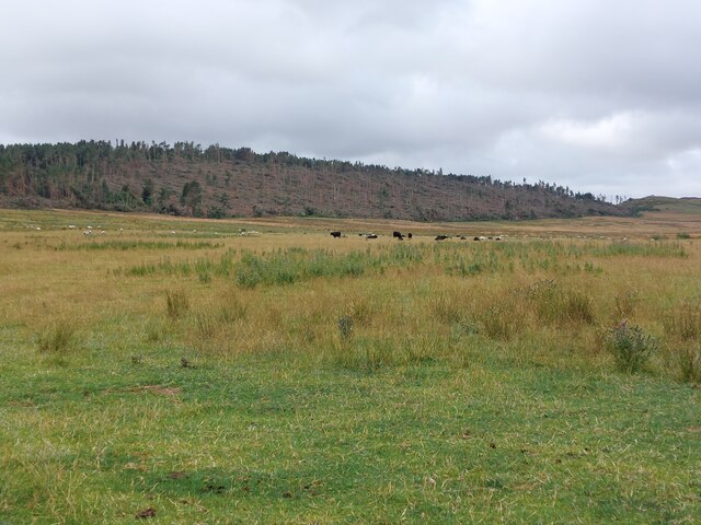
Swinhoe Strip is a woodland area located in Northumberland, England. This strip of forest is situated near the village of Swinhoe, which is in close proximity to the North Sea coastline. The woodland covers an area of approximately 200 acres and is part of the wider Northumberland Coast Area of Outstanding Natural Beauty.

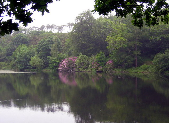
The Swinhoe Strip is predominantly composed of mixed deciduous trees, such as oak, beech, and birch, which create a rich and diverse ecosystem. The forest floor is covered in a thick carpet of mosses, ferns, and wildflowers, providing a habitat for a variety of wildlife.

The woodland is crisscrossed with a network of footpaths and trails, making it easily accessible for visitors who wish to explore and enjoy its natural beauty. There are also designated picnic areas and benches for visitors to relax and appreciate the tranquil surroundings.

Swinhoe Strip is home to a wide range of bird species, including woodpeckers, owls, and various songbirds. It is an important breeding ground for many bird species, and birdwatchers often flock to the area to observe and document the diverse avian population.

The woodland is managed by a local conservation group in collaboration with the Northumberland Wildlife Trust, ensuring the preservation and protection of the area's natural habitat. Regular conservation efforts, such as tree planting and invasive species management, are carried out to maintain the biodiversity of the forest.

Overall, Swinhoe Strip in Northumberland is a picturesque woodland area that offers visitors the chance to immerse themselves in nature, explore its diverse flora and fauna, and enjoy the tranquility of this beautiful natural space.

If you have any feedback on the listing, please let us know in the comments section below.

Swinhoe Strip Images

Images are sourced within 2km of 55.61001/-1.8609809 or Grid Reference NU0835. Thanks to Geograph Open Source API. All images are credited.

Minor Road Joining the A1 north of Middleton
Grassland west of Swinhoe A large expanse of rough grassland being grazed by cattle. Beyond, the large plantation on the eastern flank of Cockenheugh is showing extensive damage which was caused by Storm Arwen in late November 2021. The storm brough strong winds which flattened large numbers of trees in the local area.
Grassland west of Swinhoe
A large expanse of rough grassland being grazed by cattle. Beyond, the large plantation on the eastern flank of Cockenheugh is showing extensive damage which was caused by Storm Arwen in late November 2021. The storm brough strong winds which flattened large numbers of trees in the local area.
Old Milestone by road (was A1), Middleton The Milestone is located on grass verge on the East of the road.  Parish of Belford (Berwick upon Tweed District). Metal post with attached metal plate, BEL/BER L top iron post design, erected by the Berwick, Norham & Islandshires turnpike trust in the 19th Century. An earlier photograph can be found here: <a title="https://www.geograph.org.uk/photo/6076602" href="https://www.geograph.org.uk/photo/6076602">Link</a> 

Inscription reads:-  
B / 1½  : : BER / 13  

Milestone Society National ID: NB_BWBF13
Old Milestone by road (was A1), Middleton
The Milestone is located on grass verge on the East of the road.  Parish of Belford (Berwick upon Tweed District). Metal post with attached metal plate, BEL/BER L top iron post design, erected by the Berwick, Norham & Islandshires turnpike trust in the 19th Century. An earlier photograph can be found here: Link  Inscription reads:- B / 1½ : : BER / 13 Milestone Society National ID: NB_BWBF13
Ancient Wooden Barn This barn near Swinhoe Farm is over 200 years old. The tiles on the roof are made of elm wood.
Ancient Wooden Barn
This barn near Swinhoe Farm is over 200 years old. The tiles on the roof are made of elm wood.
Craggyhall Lime Kiln, Belford A small lime kiln which would have been used by the farm.
Craggyhall Lime Kiln, Belford
A small lime kiln which would have been used by the farm.
Forest Track A forest track leading to Swinhoe Lakes
Forest Track
A forest track leading to Swinhoe Lakes
Inhabitants of Swinhoe Farm Calves looking forward to Spring.
Inhabitants of Swinhoe Farm
Calves looking forward to Spring.
Junction of the old & new A1 north of Belford Belford is now bypassed
Junction of the old & new A1 north of Belford
Belford is now bypassed
Farm buildings at Sionside
Detchant Farm
Detchant Farm
Pasture and gorse Farmland to the east of Greymare Farm.
Pasture and gorse
Farmland to the east of Greymare Farm.
Approaching Detchant from the east
Grazing sheep To the west of Detchant.
Grazing sheep
To the west of Detchant.
Lindisfarne View, Middleton Hall estate The parish of Middleton lies approximately 3km north of Bamburgh Castle. The first inhabitants of Middleton lived in the area between 6000 and 12,000 years ago. This is Lindisfarne View on the estate of Middleton Hall, built in the 19th century.
Lindisfarne View, Middleton Hall estate
The parish of Middleton lies approximately 3km north of Bamburgh Castle. The first inhabitants of Middleton lived in the area between 6000 and 12,000 years ago. This is Lindisfarne View on the estate of Middleton Hall, built in the 19th century.
Brave lamb On the estate of Middleton Hall, built in the 19th century.
Brave lamb
On the estate of Middleton Hall, built in the 19th century.
Lamb nursery This group of lambs were playing together on the estate of Middleton Hall.
Lamb nursery
This group of lambs were playing together on the estate of Middleton Hall.
Upper Swinhoe Lake A view across the smaller of the two lakes north west of Swinhoe Farm
Upper Swinhoe Lake
A view across the smaller of the two lakes north west of Swinhoe Farm
Dick's Oldwalls farmstead Stored in the shed with the open door was the cutter used on the oil-seed rape crop - a plant with really tough stalks. Once cut the field is left with a stubble like nine-inch nails - you would not want to trip and fall on it!
Dick's Oldwalls farmstead
Stored in the shed with the open door was the cutter used on the oil-seed rape crop - a plant with really tough stalks. Once cut the field is left with a stubble like nine-inch nails - you would not want to trip and fall on it!
Show me another place!

Swinhoe Strip is located at Grid Ref: NU0835 (Lat: 55.61001, Lng: -1.8609809)

Unitary Authority: Northumberland

Police Authority: Northumbria

What 3 Words

///much.mango.liberated. Near Belford, Northumberland

Nearby Locations

Henshopelaw Swinhoe Strip

Related Wikis

Middleton Hall, Middleton, Northumberland

Middleton Hall is a country house near the settlement of Middleton, Northumberland, in that parish, that dates from 1871. It is listed Grade II on the...

Middleton, Northumberland

Middleton is a settlement and civil parish in Northumberland, England. The parish is situated on the North Sea coast, south of the island of Lindisfarne...

Westhall, Northumberland

Westhall is a privately owned 19th-century castellated house at Belford in Northumberland, England now in use as a farm. It is on a site with older historical...

Belford Hall

Belford Hall is a Grade I listed building, an 18th-century mansion house situated at Belford, Northumberland. The Manor of Belford was acquired by the...

Nearby Amenities

Located within 500m of 55.61001,-1.8609809
Man Made: tower
Lat/Long: 55.607457/-1.8639321
Direction: 145
Generator Method: photovoltaic
Generator Output Electricity: yes
Generator Solar Modules: lots
Generator Source: solar
Generator Type: solar_photovoltaic_panel
Location: roof
Power: generator
Lat/Long: 55.6085205/-1.8682256
The data included in this document is from www.openstreetmap.org. The data is made available under ODbL.

Have you been to Swinhoe Strip?

Leave your review of Swinhoe Strip below (or comments, questions and feedback).