Wandsworth Wood

Wood, Forest in Yorkshire Craven

England

Wandsworth Wood

Bolton Priory from above Waterfall Bridge
Bolton Priory from above Waterfall Bridge Credit: Colin Park

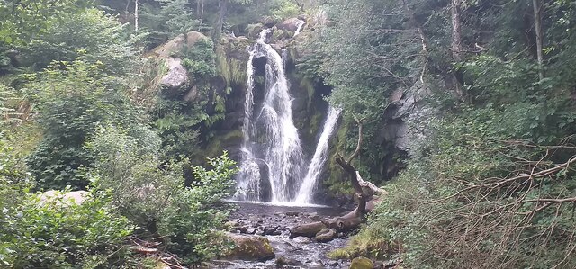
Wandsworth Wood is a picturesque woodland located in the county of Yorkshire, England. Situated in the rural area of Wood, it covers a vast expanse of approximately 100 acres, making it a popular destination for nature enthusiasts and hikers alike. The wood is renowned for its diverse range of flora and fauna, providing a haven for various wildlife species.

The woodland boasts a mixture of broadleaf and coniferous trees, including oak, beech, and pine, which create a stunning canopy of greenery throughout the year. In spring, the forest floor is carpeted with a vibrant array of wildflowers, such as bluebells and primroses, adding to the enchanting atmosphere.

A network of well-maintained trails meanders through the wood, offering visitors the opportunity to explore its natural wonders. These paths cater to all abilities, from leisurely strolls to more challenging hikes, providing breathtaking views of the surrounding countryside.

Wandsworth Wood is also home to a diverse range of wildlife. Birdwatchers can spot species such as woodpeckers, tawny owls, and jays, while lucky visitors may even catch a glimpse of deer or foxes roaming the forest. The wood's tranquil atmosphere and abundance of wildlife make it a perfect spot for birdwatching and wildlife photography.

The woodland is managed by the local council, who ensure its preservation and accessibility for the public. They have installed information boards at key points to educate visitors about the wood's history, ecology, and conservation efforts.

Overall, Wandsworth Wood is a captivating natural retreat that offers visitors the chance to immerse themselves in the beauty of Yorkshire's countryside.

If you have any feedback on the listing, please let us know in the comments section below.

Wandsworth Wood Images

Images are sourced within 2km of 53.988432/-1.8800915 or Grid Reference SE0754. Thanks to Geograph Open Source API. All images are credited.

Bolton Priory from above Waterfall Bridge
Helicopter at Devonshire Arms Hotel, Bolton Bridge
Posforth Gill waterfall Posforth Gill waterfall.
Posforth Gill waterfall
Posforth Gill waterfall.
Howgill Farm There is a benchmark cut into the east facing gable end of the farmhouse. It is on the 1st course right hand cornerstone, and adjoins a small stone built wall.
Howgill Farm
There is a benchmark cut into the east facing gable end of the farmhouse. It is on the 1st course right hand cornerstone, and adjoins a small stone built wall.
Howgill Farm A wider angle showing the east facing gable end of the farmhouse. To the right of the furthest right blue planter, cut into the lowest corner stone, is a benchmark. The mark adjoins the small stone built wall.
Howgill Farm
A wider angle showing the east facing gable end of the farmhouse. To the right of the furthest right blue planter, cut into the lowest corner stone, is a benchmark. The mark adjoins the small stone built wall.
Hazlewood, Kex Beck This gatepost is on the north side of Kex Beck. There is a benchmark cut into the east facing surface of the right hand gatepost.
Hazlewood, Kex Beck
This gatepost is on the north side of Kex Beck. There is a benchmark cut into the east facing surface of the right hand gatepost.
Hazlewood, Kex Beck A wider angle showing the complete gateway. This gateway is on the north side of Kex Beck. There is a benchmark cut into the east facing surface of the right hand gatepost.
Hazlewood, Kex Beck
A wider angle showing the complete gateway. This gateway is on the north side of Kex Beck. There is a benchmark cut into the east facing surface of the right hand gatepost.
Hazlewood, gatepost This field entrance and gatepost is on the south-east side of the A59. The footpath rises from Kex Beck to the A59. On the east side of the footpath is an old gatehole with both stone gateposts. This is the left hand gatepost with a benchmark cut into the face.
Hazlewood, gatepost
This field entrance and gatepost is on the south-east side of the A59. The footpath rises from Kex Beck to the A59. On the east side of the footpath is an old gatehole with both stone gateposts. This is the left hand gatepost with a benchmark cut into the face.
Hazlewood, gatepost This field entrance and gateposts are on the south-east side of the A59. The footpath rises from Kex Beck to the A59. On the east side of the footpath is this old gatehole with both stone gateposts. There is a benchmark cut into the face of the left hand gatepost.
Hazlewood, gatepost
This field entrance and gateposts are on the south-east side of the A59. The footpath rises from Kex Beck to the A59. On the east side of the footpath is this old gatehole with both stone gateposts. There is a benchmark cut into the face of the left hand gatepost.
Storiths, Low House Farm This cow house is on the east side of Storiths Lane. On the west facing corner stone there is a benchmark, and about 2 foot from ground level.
Storiths, Low House Farm
This cow house is on the east side of Storiths Lane. On the west facing corner stone there is a benchmark, and about 2 foot from ground level.
Storiths, Low House Farm A wider angle showing the cow house on the east side of Storiths Lane. Straight ahead is the A59, and the turn to the left goes to Hazlewood. On the west facing corner stone there is a benchmark, and about 2 foot from ground level.
Storiths, Low House Farm
A wider angle showing the cow house on the east side of Storiths Lane. Straight ahead is the A59, and the turn to the left goes to Hazlewood. On the west facing corner stone there is a benchmark, and about 2 foot from ground level.
Storiths House Farm Storiths House Farm is in the east side of Storiths Lane. According to the OS database there was a benchmark cut into this road side facing wall. From a distance, nothing could be seen, although there is plenty of vegetation hiding the lowest stone courses!
Storiths House Farm
Storiths House Farm is in the east side of Storiths Lane. According to the OS database there was a benchmark cut into this road side facing wall. From a distance, nothing could be seen, although there is plenty of vegetation hiding the lowest stone courses!
Storiths, Hill Top Farm This dwelling is on the east side of Storiths Lane. According to the OS database there is a benchmark cut into the road facing wall. There is plenty of garden vegetation along the front wall of the house covering the lowest stone courses, and no mark was obvious.
Storiths, Hill Top Farm
This dwelling is on the east side of Storiths Lane. According to the OS database there is a benchmark cut into the road facing wall. There is plenty of garden vegetation along the front wall of the house covering the lowest stone courses, and no mark was obvious.
Beamsley, Methodist church This church is on the north side of the A59, Harrogate to/from Skipton. This benchmark is cut into the south-west face of the building and is about 2 feet from ground level.
Beamsley, Methodist church
This church is on the north side of the A59, Harrogate to/from Skipton. This benchmark is cut into the south-west face of the building and is about 2 feet from ground level.
Beamsley, Methodist church A wider angle showing the church on the north side of the A59, Harrogate to/from Skipton. There is a benchmark cut into the south-west face of the building and is about 2 feet from ground level.
Beamsley, Methodist church
A wider angle showing the church on the north side of the A59, Harrogate to/from Skipton. There is a benchmark cut into the south-west face of the building and is about 2 feet from ground level.
Beamsley, Chapel Cottages The pair of cottages are on the north side of the A59 and to the west of Beamsley Methodist church. According to the OS database there is a benchmark cut into the face of one of the cottages. Today, very thick garden growth prevented viewing either of the front facias. No benchmark was seen.
Beamsley, Chapel Cottages
The pair of cottages are on the north side of the A59 and to the west of Beamsley Methodist church. According to the OS database there is a benchmark cut into the face of one of the cottages. Today, very thick garden growth prevented viewing either of the front facias. No benchmark was seen.
Beamsley, Lane Houses House number 4, Lane Houses, which is on the north side of the A59. There is a benchmark cut into the stone to the right of the front door, and on the 2nd course of stone.
Beamsley, Lane Houses
House number 4, Lane Houses, which is on the north side of the A59. There is a benchmark cut into the stone to the right of the front door, and on the 2nd course of stone.
Beamsley, Lane Houses A wider angle showing the cottages called Lane Houses which is on the north side of the A59, and literally roadside. There is a benchmark cut into the stone to the right of the front door of number 4 Lane Houses, and it is on the 2nd course of stone.
Beamsley, Lane Houses
A wider angle showing the cottages called Lane Houses which is on the north side of the A59, and literally roadside. There is a benchmark cut into the stone to the right of the front door of number 4 Lane Houses, and it is on the 2nd course of stone.
Show me another place!

Wandsworth Wood is located at Grid Ref: SE0754 (Lat: 53.988432, Lng: -1.8800915)

Division: West Riding

Administrative County: North Yorkshire

District: Craven

Police Authority: North Yorkshire

What 3 Words

///decking.phones.coining. Near Addingham, West Yorkshire

Related Wikis

Cavendish memorial fountain

The Cavendish memorial fountain is a drinking fountain erected in 1886 at Bolton Abbey, North Yorkshire, England as a memorial to Lord Frederick Cavendish...

Bolton Abbey

Bolton Abbey in Wharfedale, North Yorkshire, England, takes its name from the ruins of the 12th-century Augustinian monastery now known as Bolton Priory...
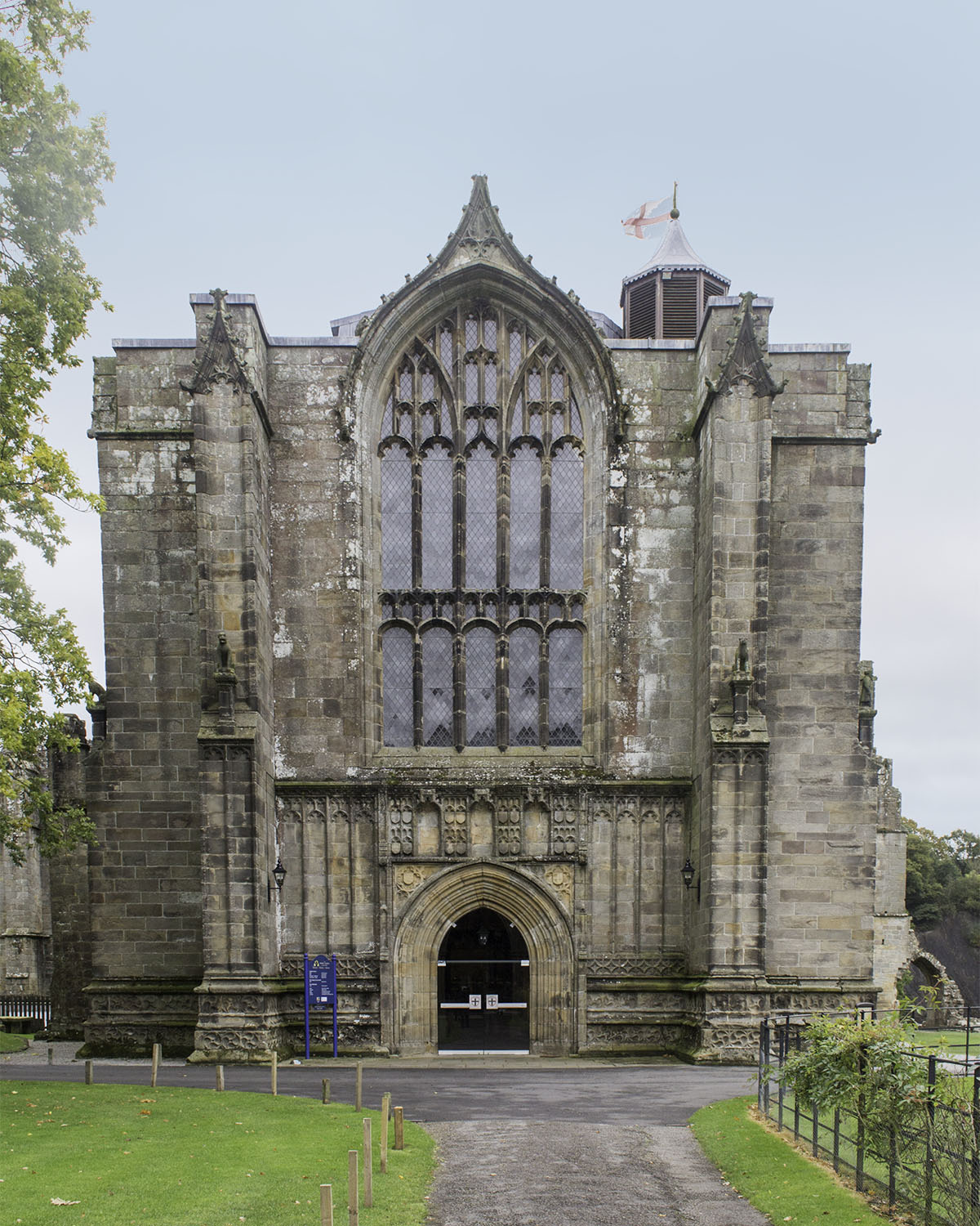
Bolton Priory

Bolton Priory, whose full title is The Priory Church of St Mary and St Cuthbert, Bolton Abbey, is a Grade I listed parish church of the Church of England...

Bolton Abbey (village)

Bolton Abbey is a village and civil parish in the Craven district of North Yorkshire, England, 22 miles (35 km) north-west of Leeds. The village lies in...

Hazlewood

Hazlewood is a hamlet in the English county of North Yorkshire. Hazlewood lies to the east of the town of Skipton by 7.5 miles (12.1 km) and is located...

Hazlewood with Storiths

Hazlewood with Storiths is a civil parish in the Craven district of North Yorkshire, England. The population of the civil parish as of the 2011 census...
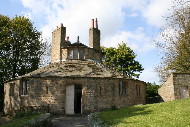
Beamsley Hospital

Beamsley Hospital is an Almshouse building at Beamsley, near Skipton in North Yorkshire, and founded in 1593 by the Lady Margaret Russell, the Countess...

Bolton Abbey railway station

Bolton Abbey railway station is on the Embsay and Bolton Abbey Steam Railway. It serves Bolton Abbey, although it is closer to Bolton Bridge, in North...

Nearby Amenities

Located within 500m of 53.988432,-1.8800915
Ford: yes
Lat/Long: 53.9910176/-1.8787863
Storiths
Alt Name: Storriths
Is In Valley: Wharfedale
Place: hamlet
Wikidata: Q5688346
Wikipedia: en:Hazlewood with Storiths
Lat/Long: 53.9853065/-1.8774018
Barrier: kissing_gate
Foot: yes
Lat/Long: 53.986863/-1.8833405
Barrier: cattle_grid
Source: Bing
Lat/Long: 53.9865208/-1.8743708
Friar's Stones
Description: burial ground
Historic: archaeological_site
Source: OS sheet 152, publ. 1854
Lat/Long: 53.9905857/-1.8788818
Friar's Stones Seat
Fixme: Is this still here??
Historic Amenity: bench
Source: OS sheet 152, publ. 1854
Lat/Long: 53.9907404/-1.87915
Holly Seat
Fixme: Is this still here??
Historic Amenity: bench
Source: OS sheet 152, publ. 1854
Lat/Long: 53.9902829/-1.8792788
Natural: spring
Source: OS sheet 152, publ. 1854
Lat/Long: 53.9878766/-1.8778948
Bench
Backrest: no
Material: wood
Lat/Long: 53.9882423/-1.8798152
Prior's Seat
Fixme: Is this still here??
Historic Amenity: bench
Source: OS sheet 152, publ. 1854
Lat/Long: 53.9869524/-1.8808667
Cat Crags
Fixme: exact location uncertain
Natural: cliff
Source: OS sheet 152, publ. 1854
Lat/Long: 53.9855361/-1.8830929
Bench
Backrest: yes
Material: wood
Lat/Long: 53.9857523/-1.8818816
Bench
Backrest: no
Material: wood
Lat/Long: 53.985298/-1.8832669
Barden Moor and Barden Fell Access Areas
Information: board
Tourism: information
Lat/Long: 53.9858986/-1.8747602
Bench
Lat/Long: 53.9922217/-1.8814379
Bench
Lat/Long: 53.9926664/-1.8819314
Post Box
Collection Times: Mo-Fr 16:15; Sa 09:30
Operator: Royal Mail
Operator Wikidata: Q638098
Post Box Type: wall
Ref: BD23 38
Royal Cypher: EIIR
Royal Cypher Wikidata: Q33102113
Lat/Long: 53.9846276/-1.8770225
Bench
Lat/Long: 53.986268/-1.8866107
Cafe
Back O' Th' Hill
Addr City: Skipton
Addr Country: GB
Addr Postcode: BD23 6HU
Addr Suburb: Storiths
Source: survey
Website: https://backothhillfarm.co.uk
Lat/Long: 53.9855722/-1.8776616
Back O' Th' Hill
Addr City: Skipton
Addr Country: GB
Addr Postcode: BD23 6HU
Addr Suburb: Storiths
Source: survey
Tourism: hostel
Website: https://backothhillfarm.co.uk
Lat/Long: 53.9855106/-1.8776616
The data included in this document is from www.openstreetmap.org. The data is made available under ODbL.

Have you been to Wandsworth Wood?

Leave your review of Wandsworth Wood below (or comments, questions and feedback).