Achnacarry Plantation

Wood, Forest in Northumberland

England

Achnacarry Plantation

Hepburn Moor, Northumberland Looking northwest over moorland on Hepburn Moor, in the distance the hill of Ros Castle can be seen.
Hepburn Moor, Northumberland Credit: Rebecca A Wills

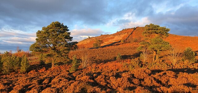
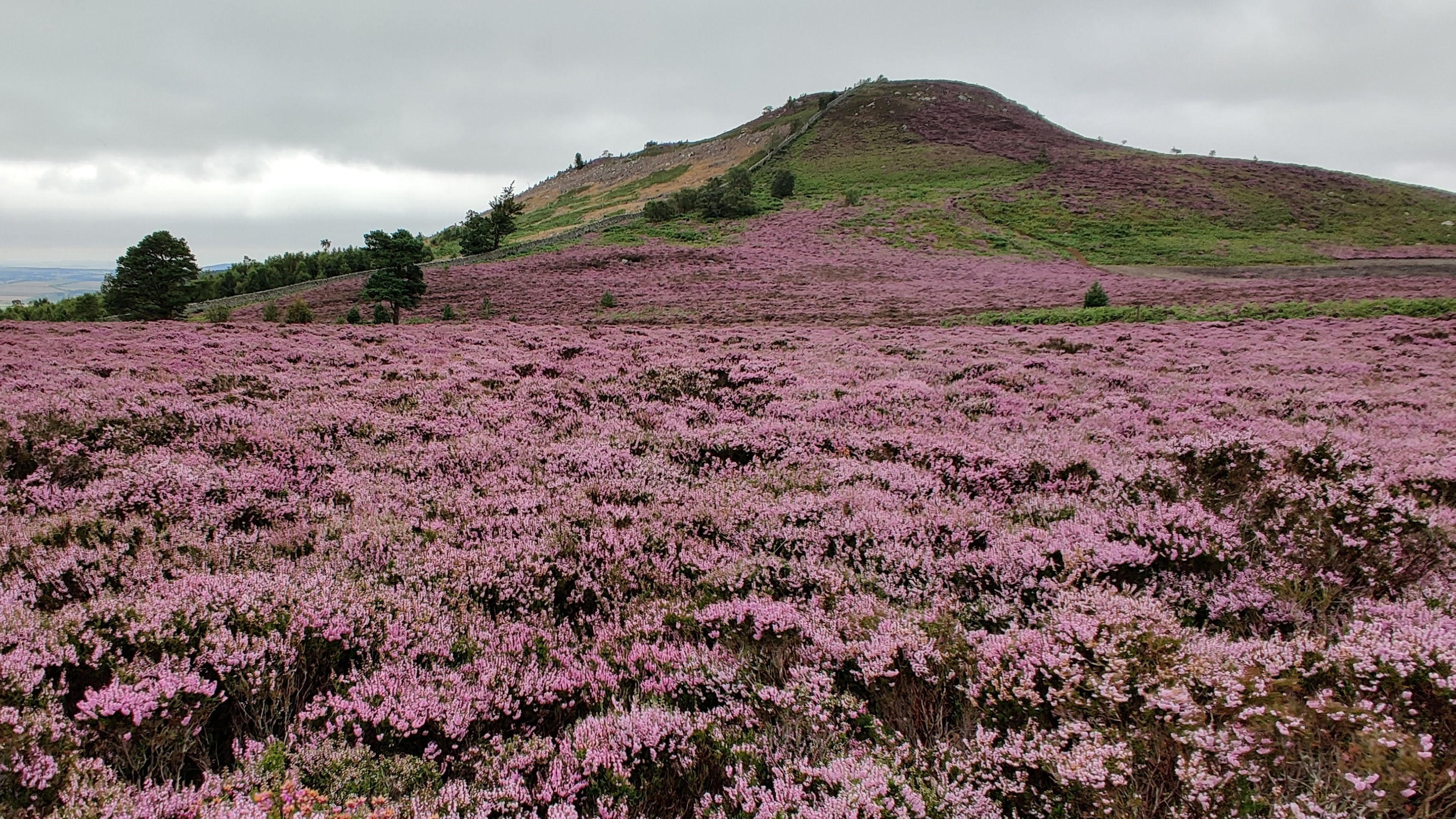
Achnacarry Plantation, located in Northumberland, is a stunning woodland area renowned for its natural beauty and diverse range of flora and fauna. Covering a vast expanse of land, the plantation is a true haven for nature enthusiasts and those seeking tranquility amidst the hustle and bustle of everyday life.

The woodlands of Achnacarry Plantation are dominated by a mix of broadleaf and coniferous trees, creating a rich tapestry of colors throughout the seasons. Towering oak, beech, and ash trees provide a majestic canopy, while spruce and pine add an evergreen touch to the landscape. The plantation is carefully managed to ensure the preservation of the woodland ecosystem and promote biodiversity.

Visitors to Achnacarry Plantation can explore a network of well-maintained trails, allowing them to immerse themselves in the natural wonders of the area. The trails cater to all levels of fitness and offer breathtaking views of the surrounding countryside. Wildlife enthusiasts will be delighted by the diverse array of animals that call the plantation home. Red squirrels, roe deer, and a wide variety of bird species can be spotted throughout the woodlands.

Achnacarry Plantation also offers educational programs and activities to engage visitors in learning about conservation and the importance of sustainable woodland management. The plantation serves as an inspiring example of how human activity can coexist harmoniously with nature.

In conclusion, Achnacarry Plantation in Northumberland is a magnificent woodland retreat that showcases the beauty of nature and provides a sanctuary for a myriad of plant and animal species. It offers a unique opportunity for visitors to connect with the natural world and gain a deeper appreciation for the wonders of the forest.

If you have any feedback on the listing, please let us know in the comments section below.

Achnacarry Plantation Images

Images are sourced within 2km of 55.532533/-1.8820553 or Grid Reference NU0726. Thanks to Geograph Open Source API. All images are credited.

Hepburn Moor, Northumberland Looking northwest over moorland on Hepburn Moor, in the distance the hill of Ros Castle can be seen.
Hepburn Moor, Northumberland
Looking northwest over moorland on Hepburn Moor, in the distance the hill of Ros Castle can be seen.
Hepburn Moor, Northumberland A view across Hepburn Moor, with Ros Castle in the distance.
Hepburn Moor, Northumberland
A view across Hepburn Moor, with Ros Castle in the distance.
Hepburn Moor, Northumberland Looking over moorland towards Ros Castle in the distance.
Hepburn Moor, Northumberland
Looking over moorland towards Ros Castle in the distance.
Hepburn Moor, Northumberland Looking towards Chillingham from the vicinity of Ros Castle.
Hepburn Moor, Northumberland
Looking towards Chillingham from the vicinity of Ros Castle.
Hepburn, Northumberland Looking southwest over farmland in the vicinity of Hepburn.
Hepburn, Northumberland
Looking southwest over farmland in the vicinity of Hepburn.
Hepburn Moor, Northumberland Looking over moorland on Hepburn Moor. Ros Castle can be seen in the distance.
Hepburn Moor, Northumberland
Looking over moorland on Hepburn Moor. Ros Castle can be seen in the distance.
Ros Castle, Northumberland Looking north up a track leading up the southern edge of Ros Castle.
Ros Castle, Northumberland
Looking north up a track leading up the southern edge of Ros Castle.
Roughting Linn Waterfall Mid-summer and only a very light trickle of water over the falls. It's a lovely spot though, straight out of a fantasy film. Note that access is not open to the public and permission should be sought from the land owner.
Roughting Linn Waterfall
Mid-summer and only a very light trickle of water over the falls. It's a lovely spot though, straight out of a fantasy film. Note that access is not open to the public and permission should be sought from the land owner.
Hepburn Moor On the horizon, the brooding mass of the Cheviot <a href="https://www.geograph.org.uk/gridref/NT9020">NT9020</a>.
Hepburn Moor
On the horizon, the brooding mass of the Cheviot NT9020.
The road over Hepburn Moor
Ros Castle Commanding hill overlooking the valley of the River Till, in the ownership of the National Trust.
Ros Castle
Commanding hill overlooking the valley of the River Till, in the ownership of the National Trust.
Trig pillar on Ros Castle The plaque reads:
Ros Castle Camp
This height with its wide prospect was a favourite resort of 
Sir Edward Grey afterwards Viscount Grey of Fallodon KG
Foreign Secretary December 1905 to December 1916.
In 1956 it was presented to the National Trust as part of a National Memorial to him.

The wall behind is part of the extensive wall surrounding the Chillingham estate.
Trig pillar on Ros Castle
The plaque reads: Ros Castle Camp This height with its wide prospect was a favourite resort of Sir Edward Grey afterwards Viscount Grey of Fallodon KG Foreign Secretary December 1905 to December 1916. In 1956 it was presented to the National Trust as part of a National Memorial to him. The wall behind is part of the extensive wall surrounding the Chillingham estate.
Walk-in toposcope on Ros Castle Ros Castle hilltop is the site of an Iron Age hillfort. The toposcope was erected by the YHA. A trig pillar with commemorative plaque <a href="https://www.geograph.org.uk/photo/7156968">NU0825 : Trig pillar on Ros Castle</a> to the left.  The wall is part of the boundary wall of the Chillingham Castle estate.
Walk-in toposcope on Ros Castle
Ros Castle hilltop is the site of an Iron Age hillfort. The toposcope was erected by the YHA. A trig pillar with commemorative plaque NU0825 : Trig pillar on Ros Castle to the left. The wall is part of the boundary wall of the Chillingham Castle estate.
View  eastwards from Ros Castle An extensive view of moorland and forest. In the middle distance, the 20.5 MW capacity Wandylaw Wind Farm <a href="https://www.geograph.org.uk/gridref/NU1224">NU1224</a>, commissioned in 2013 with ten turbines.
View eastwards from Ros Castle
An extensive view of moorland and forest. In the middle distance, the 20.5 MW capacity Wandylaw Wind Farm NU1224, commissioned in 2013 with ten turbines.
The steep path down from Ros Castle A solitary pine tree stands beside the path.
The steep path down from Ros Castle
A solitary pine tree stands beside the path.
Boundary wall of  the Chillingham Castle estate Looking north-east from the summit of Ros Castle
Boundary wall of the Chillingham Castle estate
Looking north-east from the summit of Ros Castle
Boundary wall of the Chillingham Castle estate Looking south-west from the summit of Ros Castle. Trig pillar in the foreground.
Boundary wall of the Chillingham Castle estate
Looking south-west from the summit of Ros Castle. Trig pillar in the foreground.
Wall North East of Ros Castle
Show me another place!

Achnacarry Plantation is located at Grid Ref: NU0726 (Lat: 55.532533, Lng: -1.8820553)

Unitary Authority: Northumberland

Police Authority: Northumbria

What 3 Words

///octagon.defaults.nature. Near Belford, Northumberland

Related Wikis

Nearby Amenities

Located within 500m of 55.532533,-1.8820553
Chillingham Wood
Place: locality
Lat/Long: 55.5314447/-1.8817372
The data included in this document is from www.openstreetmap.org. The data is made available under ODbL.

Have you been to Achnacarry Plantation?

Leave your review of Achnacarry Plantation below (or comments, questions and feedback).