Cerneywick Copse

Wood, Forest in Gloucestershire Cotswold

England

Cerneywick Copse

Canal Milestone Thames and Severn Canal, on the towpath of the Cerney Wick Pound (canal between locks). Replica plate in the style of the originals. Cut Benchmark represented 278.1 ft ASL (in 1900).

Inscription Walbridge / 19 / Inglesham 9¾

Milestone Society ID: TSC-19
Canal Milestone Credit: Les Minchin

Cerneywick Copse is a charming woodland located in Gloucestershire, England. Situated near the village of Cerney Wick, the copse covers an area of approximately 50 acres. This ancient woodland is renowned for its diverse flora and fauna, making it an important ecological site in the region.

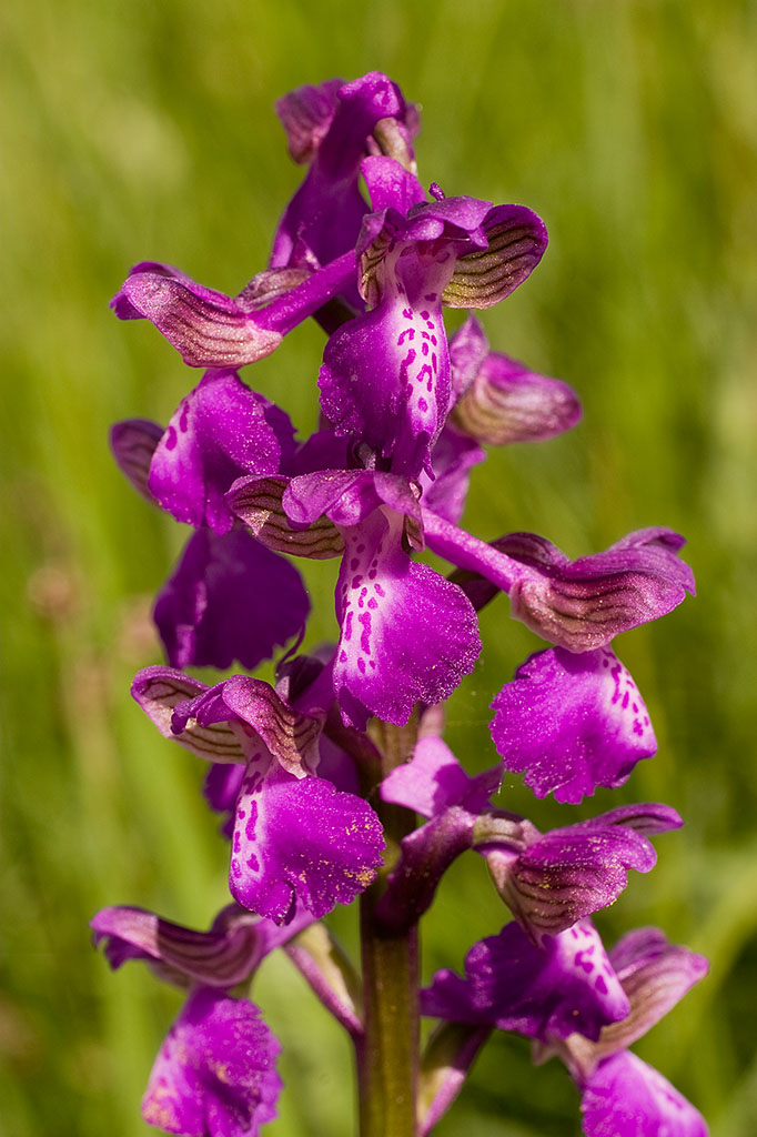
The copse is primarily composed of deciduous trees such as oak, ash, beech, and hawthorn, which create a beautiful canopy that provides shade and shelter for a variety of wildlife. The forest floor is adorned with a rich carpet of bluebells and wildflowers during the spring months, creating a picturesque scene.

The copse is crisscrossed by a network of well-maintained footpaths, allowing visitors to explore its natural beauty at their leisure. Along these paths, one may encounter an array of wildlife, including deer, foxes, badgers, and a wide variety of bird species. Birdwatchers are particularly drawn to Cerneywick Copse due to the presence of woodpeckers, nightingales, and tawny owls.

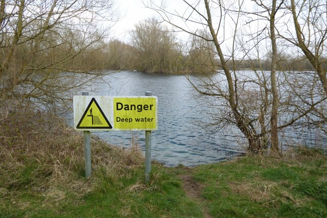
Furthermore, the copse is home to several small streams and ponds, which provide habitats for frogs, newts, and dragonflies. These aquatic features add to the overall biodiversity of the area.

Cerneywick Copse is a popular destination for nature enthusiasts, hikers, and families seeking a peaceful retreat. The copse offers a tranquil setting for picnics, photography, and simply immersing oneself in the beauty of the natural world. With its abundant wildlife and breathtaking scenery, Cerneywick Copse is truly a gem within the Gloucestershire countryside.

If you have any feedback on the listing, please let us know in the comments section below.

Cerneywick Copse Images

Images are sourced within 2km of 51.656674/-1.9058017 or Grid Reference SU0695. Thanks to Geograph Open Source API. All images are credited.

Canal Milestone Thames and Severn Canal, on the towpath of the Cerney Wick Pound (canal between locks). Replica plate in the style of the originals. Cut Benchmark represented 278.1 ft ASL (in 1900).

Inscription Walbridge / 19 / Inglesham 9¾

Milestone Society ID: TSC-19
Canal Milestone
Thames and Severn Canal, on the towpath of the Cerney Wick Pound (canal between locks). Replica plate in the style of the originals. Cut Benchmark represented 278.1 ft ASL (in 1900). Inscription Walbridge / 19 / Inglesham 9¾ Milestone Society ID: TSC-19
Thames & Severn canal Milestone Modern plate placed there by volunteers of the Cotswold Canals Trust ( <span class="nowrap"><a title="https://cotswoldcanals.org/" rel="nofollow ugc noopener" href="https://cotswoldcanals.org/">Link</a><img style="margin-left:2px;" alt="External link" title="External link - shift click to open in new window" src="https://s1.geograph.org.uk/img/external.png" width="10" height="10"/></span> ). The plate is a respectful clone of the style of the original plates used on this canal. The modern bridge on the "Spine Road" is 200m to the left and can clearly be seen on an alternative view - <a href="https://www.geograph.org.uk/photo/6539254">SU0797 : Thames & Severn Path near South Cerney</a>. An earlier image shows the stone before it was pieced together, and set upright see <a href="https://www.geograph.org.uk/photo/1082683">SU0797 : Thames & Severn Canal milepost near Spine Road Bridge</a>

Inscription: Walbridge / 18½ / Inglesham / 10¼

Milestone Society National ID: TSC-18½
Thames & Severn canal Milestone
Modern plate placed there by volunteers of the Cotswold Canals Trust ( LinkExternal link ). The plate is a respectful clone of the style of the original plates used on this canal. The modern bridge on the "Spine Road" is 200m to the left and can clearly be seen on an alternative view - SU0797 : Thames & Severn Path near South Cerney. An earlier image shows the stone before it was pieced together, and set upright see SU0797 : Thames & Severn Canal milepost near Spine Road Bridge Inscription: Walbridge / 18½ / Inglesham / 10¼ Milestone Society National ID: TSC-18½
The Thames Path entering Ashton Keynes The Thames Path passing Kentend Farm as it enters Ashton Keynes.
The Thames Path entering Ashton Keynes
The Thames Path passing Kentend Farm as it enters Ashton Keynes.
Sports field, Ashton Keynes
Footbridge on the Thames Path The Thames Path crossing a footbridge between two lake created from gravel extraction just east of the village of Ashton Keynes.
Footbridge on the Thames Path
The Thames Path crossing a footbridge between two lake created from gravel extraction just east of the village of Ashton Keynes.
The Thames Path The Thames Path to the east of Ashton Keynes.
The Thames Path
The Thames Path to the east of Ashton Keynes.
Manorbrook Lake A deep water warning sign beside Manorbrook Lake.
Manorbrook Lake
A deep water warning sign beside Manorbrook Lake.
The Thames Path The Thames Path near Manorbrook Lake.
The Thames Path
The Thames Path near Manorbrook Lake.
Remains of an old farm bridge Remains of an old farm bridge crossing the River Thames, I photographed the same bridge in 2011 when walking the Thames Path <a href="https://www.geograph.org.uk/photo/2390996">SU0793 : Farm bridge over the Thames</a>.
Remains of an old farm bridge
Remains of an old farm bridge crossing the River Thames, I photographed the same bridge in 2011 when walking the Thames Path SU0793 : Farm bridge over the Thames.
Entrance to Cleveland Lakes Viewed from the Thames Path I photographed this same gate in 2011 <a href="https://www.geograph.org.uk/photo/2390988">SU0794 : Sign for Cleveland Lakes</a>.
Entrance to Cleveland Lakes
Viewed from the Thames Path I photographed this same gate in 2011 SU0794 : Sign for Cleveland Lakes.
Footbridge on the Thames Path
The River Thames The River Thames near Bournelake Stalls.
The River Thames
The River Thames near Bournelake Stalls.
Sign for the Thames Path Signpost on the trackbed on a former railway near Cricklade.  The sign indicates the route of the Thames Path.
Sign for the Thames Path
Signpost on the trackbed on a former railway near Cricklade. The sign indicates the route of the Thames Path.
Former railway near Cricklade This former railway trackbed near Cricklade is now a cycleway and footpath.
Former railway near Cricklade
This former railway trackbed near Cricklade is now a cycleway and footpath.
The River Thames The River Thames near Cricklade.
The River Thames
The River Thames near Cricklade.
Roundhouse and Cerney Wick Lock A disused lock on the defunct Thames and Severn Canal.  The building on the right is a lockkeeper's house.  It is one of five on this canal; they are known as Roundhouses.
Roundhouse and Cerney Wick Lock
A disused lock on the defunct Thames and Severn Canal. The building on the right is a lockkeeper's house. It is one of five on this canal; they are known as Roundhouses.
The A419 passing Cerney Wick The A419 follows the route of Ermin Way, a Roman Road at this point.  The road was dualled some years ago, the old A449 runs on a parallel course nearby.
The A419 passing Cerney Wick
The A419 follows the route of Ermin Way, a Roman Road at this point. The road was dualled some years ago, the old A449 runs on a parallel course nearby.
Lake at the Cotswold Water Park The Cotswold Water Park covers around 40 square miles on the borders of Gloucestershire and Wiltshire.  The park is made up of artificial lakes which have been developed in former gravel pits, to cater for leisure activities.

The Water Park has two parts, the larger around the villages of South Cerney and Ashton Keynes, while the other is further east around Fairford and Lechlade.
Lake at the Cotswold Water Park
The Cotswold Water Park covers around 40 square miles on the borders of Gloucestershire and Wiltshire. The park is made up of artificial lakes which have been developed in former gravel pits, to cater for leisure activities. The Water Park has two parts, the larger around the villages of South Cerney and Ashton Keynes, while the other is further east around Fairford and Lechlade.
Show me another place!

Cerneywick Copse is located at Grid Ref: SU0695 (Lat: 51.656674, Lng: -1.9058017)

Administrative County: Gloucestershire

District: Cotswold

Police Authority: Gloucestershire

What 3 Words

///inserting.loyal.sparkles. Near Ashton Keynes, Wiltshire

Nearby Locations

Cerneywick Copse

Related Wikis

Elmlea Meadows

Elmlea Meadows (grid reference SU079948) is a 6.9-hectare (17-acre) biological Site of Special Scientific Interest in Gloucestershire, notified in 1989...

Upper Waterhay Meadow

Upper Waterhay Meadow (grid reference SU068937) is a 2.8 hectare biological Site of Special Scientific Interest in north Wiltshire, England, notified in...

Wildmoorway Meadows

Wildmoorway Meadows (grid reference SU066973) is a 12.6-hectare (31-acre) biological Site of Special Scientific Interest in Gloucestershire, to the east...

South Cerney railway station

South Cerney railway station was on the Midland and South Western Junction Railway in Gloucestershire. The station opened on 18 December 1883 on the Swindon...

Ashton Keynes

Ashton Keynes is a village and civil parish in north Wiltshire, England which borders with Gloucestershire. The village is about 5 miles (8 km) south of...

South Cerney

South Cerney is a village and civil parish in the Cotswold district of Gloucestershire, 3 miles south of Cirencester and close to the border with Wiltshire...

Church of All Hallows, South Cerney

The Church of All Hallows is an Anglican parish church in the village of South Cerney, Gloucestershire. The church is of Norman origins, with medieval...

Latton, Wiltshire

Latton is a village and civil parish in Wiltshire, England, 1.5 miles (2.4 km) north of Cricklade, on the county border with Gloucestershire. The village...

Nearby Amenities

Located within 500m of 51.656674,-1.9058017
Barrier: kissing_gate
Bicycle: no
Foot: yes
Lat/Long: 51.6576517/-1.9055097
Barrier: stile
Lat/Long: 51.657928/-1.9061478
Tourism: information
Lat/Long: 51.6587168/-1.8998978
The data included in this document is from www.openstreetmap.org. The data is made available under ODbL.

Have you been to Cerneywick Copse?

Leave your review of Cerneywick Copse below (or comments, questions and feedback).