Culross

Settlement in Fife

Scotland

Culross

A985 north of Culross, Fife
A985 north of Culross, Fife Credit: Alpin Stewart

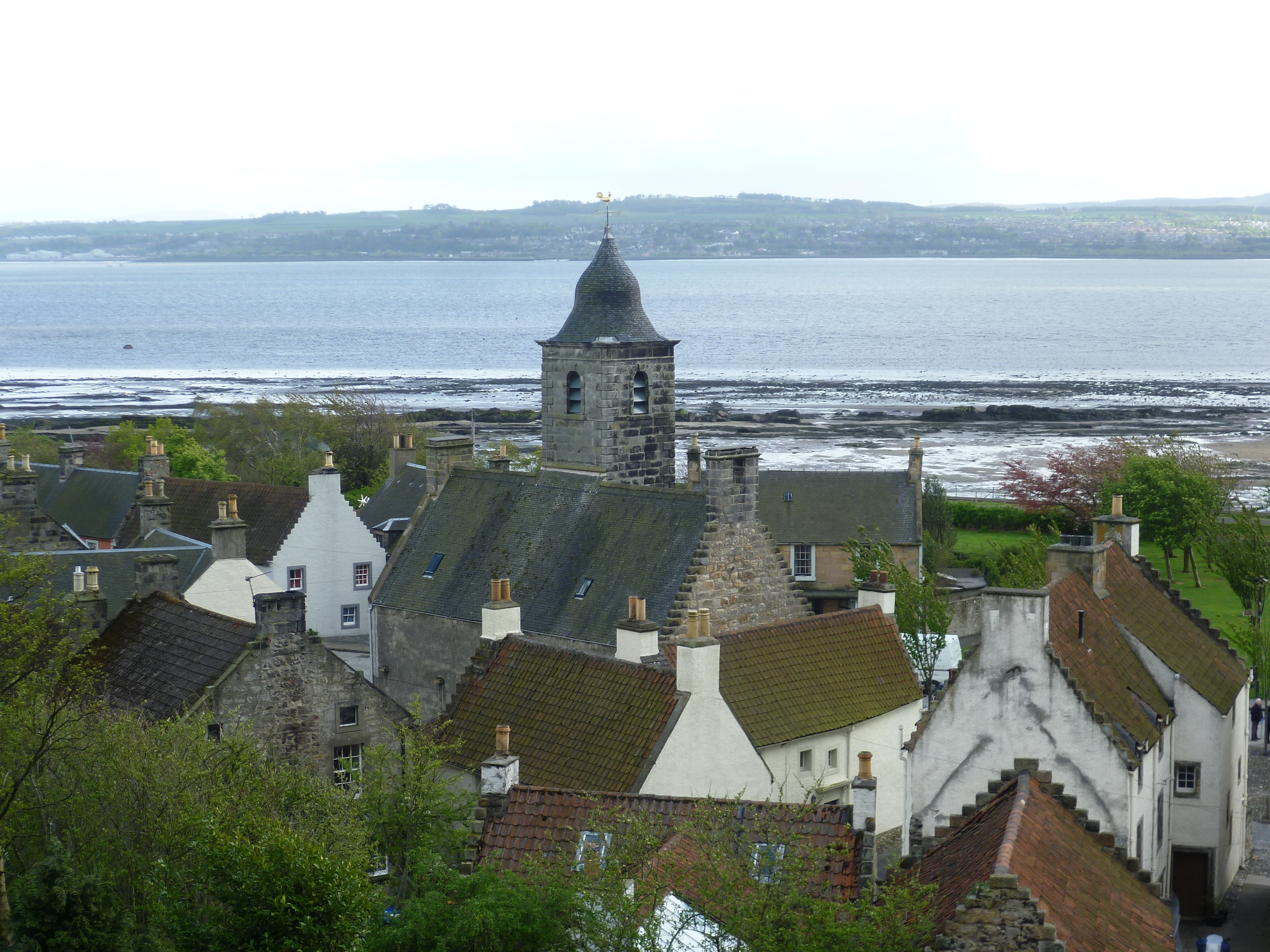
Culross, located in the county of Fife, Scotland, is a picturesque village with a rich historical and architectural heritage. Situated on the northern bank of the Firth of Forth, Culross is often referred to as a "time capsule" due to its remarkably well-preserved 17th-century appearance.

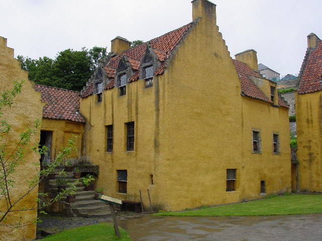
The village's charm lies in its narrow cobbled streets, traditional buildings, and quaint cottages made of stone with red-tiled roofs. Many of these buildings are protected as national monuments, including the Culross Palace, a stunning mansion built in the 16th century. This magnificent residence showcases exquisite period furniture and is surrounded by beautiful gardens.

Culross Abbey, founded in 1217, is another notable landmark in the village. This Gothic-style monastery still maintains its original structure, with its impressive ruins serving as a reminder of its former grandeur.

The town's economy historically relied on coal mining, salt production, and trade. Today, Culross has shifted towards tourism, attracting visitors who are keen to explore its historical treasures. The village is also renowned for its involvement in the TV series "Outlander," with many of its locations featuring in the show.

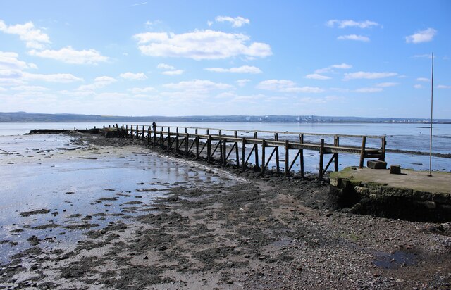
In addition to its architectural wonders, Culross offers stunning views of the Firth of Forth and has a charming harbor where visitors can take leisurely walks. The village also hosts various events throughout the year, including a popular annual summer fair.

Overall, Culross is a hidden gem that transports visitors back in time, providing a glimpse into Scotland's rich history and architectural heritage.

If you have any feedback on the listing, please let us know in the comments section below.

Culross Images

Images are sourced within 2km of 56.056507/-3.629838 or Grid Reference NS9886. Thanks to Geograph Open Source API. All images are credited.

A985 north of Culross, Fife
Culross Pier A very pretty little village with a past history of coal mining under the sea using a horse powered 'Egyptian wheel'. The pier has been restored in recent years. The tide was well in so there wasn't much to see.
Culross Pier
A very pretty little village with a past history of coal mining under the sea using a horse powered 'Egyptian wheel'. The pier has been restored in recent years. The tide was well in so there wasn't much to see.
Railway line at Culross The Dunfermline to Kincardine-on-Forth Railway was opened in 1906. The line was built here on an embankment at the edge of the shore, which pushed the shoreline out into the Forth by up to 50m in places. Passenger services were not well used and ceased in 1930. Goods traffic ran until 1964. The construction of coal-fired power stations at Kincardine in 1962 and Longannet in 1970 led to a revival of the line, but both of these have now closed and freight traffic no longer runs on the line. There is a possibility that passenger services could perhaps be reinstated on the line in the future. The sleepers here are steel - these have a very long life (typically 50 years) and can be recycled when they need to be replaced.
Railway line at Culross
The Dunfermline to Kincardine-on-Forth Railway was opened in 1906. The line was built here on an embankment at the edge of the shore, which pushed the shoreline out into the Forth by up to 50m in places. Passenger services were not well used and ceased in 1930. Goods traffic ran until 1964. The construction of coal-fired power stations at Kincardine in 1962 and Longannet in 1970 led to a revival of the line, but both of these have now closed and freight traffic no longer runs on the line. There is a possibility that passenger services could perhaps be reinstated on the line in the future. The sleepers here are steel - these have a very long life (typically 50 years) and can be recycled when they need to be replaced.
Coastal path, Culross The path passes the public car park, which has capacity for just over 100 cars.
Coastal path, Culross
The path passes the public car park, which has capacity for just over 100 cars.
Culross Pier The original pier consisted of a stone built structure about 100m out into the Forth linked to another stone pier attached to the shore (just visible on the left) by a wooden platform. With the construction of the new railway line along the edge of the shore which opened in 1906, an embankment was built out from the original shoreline for the railway to run along <a href="https://www.geograph.org.uk/photo/6856806">NS9885 : Railway line at Culross</a> and this cut the shore side of the pier in half. Only the end which attached to the wooden platform still extended into the Forth. The northern end can still be seen between the road and railway <a href="https://www.geograph.org.uk/photo/6856835">NS9885 : Old anchor, Culross</a>.

Over time both sections of stone pier deteriorated. The wooden platform eventually disappeared. In 2007 work started to restore the pier and volunteers have since rebuilt the platform in the same form as the original, linking the shore to the outer structure once again. The work on the outer pier is nearing completion.
Culross Pier
The original pier consisted of a stone built structure about 100m out into the Forth linked to another stone pier attached to the shore (just visible on the left) by a wooden platform. With the construction of the new railway line along the edge of the shore which opened in 1906, an embankment was built out from the original shoreline for the railway to run along NS9885 : Railway line at Culross and this cut the shore side of the pier in half. Only the end which attached to the wooden platform still extended into the Forth. The northern end can still be seen between the road and railway NS9885 : Old anchor, Culross. Over time both sections of stone pier deteriorated. The wooden platform eventually disappeared. In 2007 work started to restore the pier and volunteers have since rebuilt the platform in the same form as the original, linking the shore to the outer structure once again. The work on the outer pier is nearing completion.
Railway line at Culross The Dunfermline to Kincardine-on-Forth Railway was opened in 1906. The line was built here on an embankment at the edge of the shore, which pushed the shoreline out into the Forth by up to 50m in places. Passenger services were not well used and ceased in 1930. Goods traffic ran until 1964. The construction of coal-fired power stations at Kincardine in 1962 and Longannet in 1970 led to a revival of the line, but both of these have now closed and freight traffic no longer runs on the line. There is a possibility that passenger services could perhaps be reinstated on the line in the future.

Compare this image with one taken in 2021 <a href="https://www.geograph.org.uk/photo/6856806">NS9885 : Railway line at Culross</a>, when the Longannet chimney was still to be seen in the distance.
Railway line at Culross
The Dunfermline to Kincardine-on-Forth Railway was opened in 1906. The line was built here on an embankment at the edge of the shore, which pushed the shoreline out into the Forth by up to 50m in places. Passenger services were not well used and ceased in 1930. Goods traffic ran until 1964. The construction of coal-fired power stations at Kincardine in 1962 and Longannet in 1970 led to a revival of the line, but both of these have now closed and freight traffic no longer runs on the line. There is a possibility that passenger services could perhaps be reinstated on the line in the future. Compare this image with one taken in 2021 NS9885 : Railway line at Culross, when the Longannet chimney was still to be seen in the distance.
Culross Pier Looking towards the end of the pier. This is the original stone built structure about 100m out into the Forth linked to another stone pier attached to the shore by a wooden platform. A slow process of restoring the pier is approaching completion, with only the final few metres at the far end <a href="https://www.geograph.org.uk/photo/7757964">NS9885 : The end of the pier</a> still to be concreted over.
Culross Pier
Looking towards the end of the pier. This is the original stone built structure about 100m out into the Forth linked to another stone pier attached to the shore by a wooden platform. A slow process of restoring the pier is approaching completion, with only the final few metres at the far end NS9885 : The end of the pier still to be concreted over.
The end of the pier A slow process of restoring Culross Pier is approaching completion, with only the final few metres at the far end still to be concreted over.
The end of the pier
A slow process of restoring Culross Pier is approaching completion, with only the final few metres at the far end still to be concreted over.
The western end of Culross Seen from near the end of Culross Pier. The wooden posts (which have words engraved on them) have been installed as part of the restoration of the pier.
The western end of Culross
Seen from near the end of Culross Pier. The wooden posts (which have words engraved on them) have been installed as part of the restoration of the pier.
Culross Seen from the end of Culross Pier.
Culross
Seen from the end of Culross Pier.
Dunimarle Castle and houses on Balgownie West Seen from Culross Pier.
Dunimarle Castle and houses on Balgownie West
Seen from Culross Pier.
Wooden post, Culross Pier One of several wooden posts (which have words engraved on them) which have been installed as part of the restoration of the pier.
Wooden post, Culross Pier
One of several wooden posts (which have words engraved on them) which have been installed as part of the restoration of the pier.
A quiet place for a read Enjoying a book on the pier at Culross.
A quiet place for a read
Enjoying a book on the pier at Culross.
Wooden platform to the end of Culross Pier Looking from the original stone-built pier about 100m out into the Forth. It is linked to another stone pier attached to the shore by the wooden platform. The jumbled stones to the left show that the original pier once extended slightly closer to the shore.
Wooden platform to the end of Culross Pier
Looking from the original stone-built pier about 100m out into the Forth. It is linked to another stone pier attached to the shore by the wooden platform. The jumbled stones to the left show that the original pier once extended slightly closer to the shore.
Culross Pier The original pier consisted of a stone built structure about 100m out into the Forth linked to another stone pier attached to the shore (just visible on the right) by a wooden platform. 

Over time both sections of stone pier deteriorated. The wooden platform eventually disappeared. In 2007 work started to restore the pier and volunteers have since rebuilt the platform in the same form as the original, linking the shore to the outer structure once again. The work on the outer pier is nearing completion.
Culross Pier
The original pier consisted of a stone built structure about 100m out into the Forth linked to another stone pier attached to the shore (just visible on the right) by a wooden platform. Over time both sections of stone pier deteriorated. The wooden platform eventually disappeared. In 2007 work started to restore the pier and volunteers have since rebuilt the platform in the same form as the original, linking the shore to the outer structure once again. The work on the outer pier is nearing completion.
Sea defences, Culross Looking along the shore to the east of the pier. The closed Dunfermline to Kincardine-on-Forth Railway line runs along the embankment at the edge of the shore.
Sea defences, Culross
Looking along the shore to the east of the pier. The closed Dunfermline to Kincardine-on-Forth Railway line runs along the embankment at the edge of the shore.
Culross Pier The original pier consisted of a stone built structure about 100m out into the Forth linked to another stone pier attached to the shore (visible on the right) by a wooden platform. 

Over time both sections of stone pier deteriorated. The wooden platform eventually disappeared. In 2007 work started to restore the pier and volunteers have since rebuilt the platform in the same form as the original, linking the shore to the outer structure once again. The work on the outer pier is nearing completion.

Grangemouth refinery can be seen in the distance on the far side of the Forth.
Culross Pier
The original pier consisted of a stone built structure about 100m out into the Forth linked to another stone pier attached to the shore (visible on the right) by a wooden platform. Over time both sections of stone pier deteriorated. The wooden platform eventually disappeared. In 2007 work started to restore the pier and volunteers have since rebuilt the platform in the same form as the original, linking the shore to the outer structure once again. The work on the outer pier is nearing completion. Grangemouth refinery can be seen in the distance on the far side of the Forth.
Show me another place!

Culross is located at Grid Ref: NS9886 (Lat: 56.056507, Lng: -3.629838)

Unitary Authority: Fife

Police Authority: Fife

What 3 Words

///shadowing.resettle.cubic. Near High Valleyfield, Fife

Nearby Locations

Culross Erskine Brae

Related Wikis

Culross

Culross (/ˈkurəs/) (Scottish Gaelic: Cuileann Ros, 'holly point or promontory') is a village and former royal burgh, and parish, in Fife, Scotland. According...

Culross Palace

Culross Palace is a late 16th to early 17th century merchant's house in Culross, Fife, Scotland. The palace, or "Great Lodging", was constructed between...

Culross mercat cross

Culross mercat cross is located in Culross, Fife, Scotland. Now Category A listed, its base dates to the original 16th-century mercat cross. Its shaft...

Crail market cross

Crail market cross is located in Crail, Fife, Scotland. Erected in the early 17th century and now Category B listed, it is a mercat cross with a square...

Nearby Amenities

Located within 500m of 56.056507,-3.629838
Culross
Name Sco: Courus
Place: village
Population: 395
Source: npe
Wikidata: Q2424554
Wikipedia: en:Culross
Lat/Long: 56.0556633/-3.6283699
Post Box
Collection Times: Mo-Fr 16:45; Sa 10:00
Operator: Royal Mail
Post Box Type: lamp
Ref: KY12 159
Royal Cypher: scottish_crown
Lat/Long: 56.0548718/-3.6285567
Recycling
Lat/Long: 56.0552962/-3.6224757
Cafe
Biscuit Cafe
Addr City: Culross
Addr Country: GB
Addr Place: Sandhaven
Addr Postcode: KY12 8JG
Diet Vegetarian: yes
Opening Hours: Mo-Su 10:00-17:00
Lat/Long: 56.0555862/-3.6303941
Post Box
Collection Times: Mo-Fr 09:00; Sa 07:00
Operator: Royal Mail
Operator Wikidata: Q638098
Ref: KY12 128
Royal Cypher: scottish_crown
Lat/Long: 56.0579577/-3.62625
Power: pole
Lat/Long: 56.0600279/-3.6341477
Power: pole
Lat/Long: 56.0602127/-3.6328416
Power: pole
Lat/Long: 56.0603997/-3.631516
Power: pole
Lat/Long: 56.0605804/-3.6301595
Power: pole
Lat/Long: 56.0607643/-3.6287889
Entrance: yes
Wheelchair: no
Lat/Long: 56.0555505/-3.6311474
Culross Pottery and Gallery
Addr City: Culross
Addr Country: GB
Addr Place: Sandhaven
Addr Postcode: KY12 8JG
Shop: art
Wheelchair: no
Lat/Long: 56.0555801/-3.6302526
Admiral Lord Thomas Alexander Cochrane
Artwork Type: statue
Subject Wikidata: Q334994
Tourism: artwork
Lat/Long: 56.0553143/-3.6307484
On sacred ground
Board Type: history
Information: board
Tourism: information
Lat/Long: 56.0579245/-3.6261151
Leisure: pitch
Sport: table_tennis
Lat/Long: 56.0548666/-3.6324156
Culross Abbey Ruins
Fee: no
Historic: ruins
Lat/Long: 56.0581361/-3.6254814
Historic: memorial
Memorial: war_memorial
Lat/Long: 56.0550503/-3.6323502
Culross
Board Type: history
Information: board
Tourism: information
Lat/Long: 56.0549283/-3.6329842
Culross Abbey
Board Type: history
Check Date: 2022-03-08
Information: board
Tourism: information
Lat/Long: 56.0581825/-3.6262949
Mercat Cross
Disused: yes
Historic: pillory
Material: stone
Memorial: mercat_cross
Name En: Market Cross of Culross
Tourism: attraction
Wikidata: Q17567823
Lat/Long: 56.0556308/-3.6284197
Information: board
Operator: Fife Coast and Countryside Trust
Tourism: information
Lat/Long: 56.0550132/-3.6324951
Bus Stop
Balgownie West
Bench: no
Bus: yes
Departures Board: timetable
Naptan AtcoCode: 6500D0635
Naptan NaptanCode: 34323867
Public Transport: platform
Shelter: no
Lat/Long: 56.055106/-3.6371909
Information: guidepost
Tourism: information
Lat/Long: 56.0551852/-3.6303824
The work of God
Board Type: history
Information: board
Tourism: information
Lat/Long: 56.0579804/-3.6249569
Disused Amenity: cafe
Level: 0
Lat/Long: 56.0556693/-3.6281121
Toilets
Check Date: 2023-08-04
Fee: no
Level: 0
Wheelchair: yes
Lat/Long: 56.0556895/-3.631322
Information: guidepost
Tourism: information
Lat/Long: 56.0549417/-3.6329497
Bus Stop
Culross The Palace
Bench: yes
Bin: no
Lit: no
Naptan AtcoCode: 6500D0633
Naptan NaptanCode: 34323865
Shelter: yes
Tactile Paving: no
Lat/Long: 56.0551381/-3.6305984
Cafe
Bessie's Cafe
Diet Vegetarian: yes
Indoor Seating: yes
Level: 0
Opening Hours: Th-Mo 10:00-05:00
Outdoor Seating: yes
Lat/Long: 56.055565/-3.6313251
Bus Stop
Culross The Palace
Bench: yes
Bin: yes
Lit: no
Shelter: no
Tactile Paving: no
Lat/Long: 56.055198/-3.6305253
Tron
Historic: memorial
Memorial: obelisk
Lat/Long: 56.0552548/-3.6304436
Bus Stop
Low Causeway
Bus: yes
Departures Board: timetable
Naptan AtcoCode: 6500D0631
Naptan NaptanCode: 34323873
Network: Fife
Operator: Stagecoach
Public Transport: platform
Shelter: no
Surface: tactile_paving
Lat/Long: 56.0553284/-3.6273273
Bus Stop
Low Causeway
Bus: yes
Departures Board: timetable
Naptan AtcoCode: 6500D0629
Naptan NaptanCode: 34323869
Network: Fife
Operator: Stagecoach
Public Transport: platform
Surface: tactile_paving
Lat/Long: 56.0552854/-3.6269346
Bus Stop
Culross Primary School
Bus: yes
Departures Board: timetable
Naptan AtcoCode: 6500D0627
Naptan NaptanCode: 34323892
Network: Fife
Operator: Stagecoach
Public Transport: platform
Surface: tactile_paving
Lat/Long: 56.0558375/-3.6252376
Bus Stop
Culross Primary School
Bus: yes
Departures Board: timetable
Naptan AtcoCode: 6500D0628
Naptan NaptanCode: 34323924
Network: Fife
Operator: Stagecoach
Public Transport: platform
Surface: tactile_paving
Lat/Long: 56.0560156/-3.6250167
Crossing Barrier: gate
Railway: crossing
Lat/Long: 56.0546891/-3.6320867
Addr Housenumber: 6
Addr Street: Mid Causeway
Lat/Long: 56.0555335/-3.6286193
Traffic Calming: cushion
Lat/Long: 56.0563432/-3.6240458
Generator Method: photovoltaic
Generator Output Electricity: yes
Generator Source: solar
Generator Type: solar_photovoltaic_panel
Power: generator
Lat/Long: 56.0548783/-3.6272133
Charging Station
Access: yes
Capacity: 1
Lat/Long: 56.0549239/-3.6337441
Name Fr: Culross
Shop: travel_agency
Lat/Long: 56.0556063/-3.6280204
Bench
Lat/Long: 56.0552514/-3.622368
Information: guidepost
Operator: Fife Coast and Countryside Trust
Tourism: information
Lat/Long: 56.0549987/-3.6326573
Bench
Lat/Long: 56.0548784/-3.632462
Bench
Lat/Long: 56.0548633/-3.6324647
Artwork Type: sculpture
Tourism: artwork
Lat/Long: 56.0548693/-3.6321958
Covered: no
Leisure: picnic_table
Lat/Long: 56.0548884/-3.6320749
Covered: no
Leisure: picnic_table
Lat/Long: 56.0548492/-3.6320731
Covered: no
Leisure: picnic_table
Lat/Long: 56.055058/-3.6321157
Covered: no
Leisure: picnic_table
Lat/Long: 56.055086/-3.6320035
Covered: no
Leisure: picnic_table
Lat/Long: 56.054997/-3.6319959
Defibrillator
Defibrillator Location: On outside wall of Red Lion Inn in corner next to main entrance
Emergency: defibrillator
Mapillary: 385573197575988
Survey Date: 2024-03-24
Lat/Long: 56.0549093/-3.6290478
Entrance: yes
Lat/Long: 56.0583211/-3.6256162
Addr Housenumber: 20
Addr Street: Mid Causeway
Lat/Long: 56.0551471/-3.6293258
Addr Housenumber: 4
Addr Street: Mid Causeway
Lat/Long: 56.0554844/-3.6286271
Addr Housenumber: 8
Addr Street: Mid Causeway
Lat/Long: 56.0553948/-3.6288027
Addr Housenumber: 17
Addr Street: Low Causewayside
Lat/Long: 56.0553431/-3.6270293
Addr Housename: Upper Neuk
Addr Street: Low Causewayside
Lat/Long: 56.0553494/-3.6269691
Information: board
Tourism: information
Lat/Long: 56.0551975/-3.6230921
Information: board
Tourism: information
Lat/Long: 56.0551819/-3.6230151
Waste Basket
Lat/Long: 56.0551486/-3.6229859
Bench
Backrest: yes
Lat/Long: 56.0546556/-3.6309333
Bench
Backrest: yes
Lat/Long: 56.0547252/-3.6314107
Waste Basket
Lat/Long: 56.0547213/-3.6313346
Bench
Backrest: yes
Lat/Long: 56.0547964/-3.631316
Bench
Backrest: yes
Lat/Long: 56.0548527/-3.6313195
Bench
Backrest: yes
Lat/Long: 56.0549446/-3.6313071
Bench
Backrest: yes
Lat/Long: 56.0549816/-3.6314506
Waste Basket
Lat/Long: 56.0549786/-3.6312904
Bench
Backrest: yes
Lat/Long: 56.0551211/-3.6312928
Bench
Backrest: yes
Lat/Long: 56.0550972/-3.6313002
Waste Basket
Lat/Long: 56.0550803/-3.6313042
Information: board
Tourism: information
Lat/Long: 56.0547405/-3.6334059
Information: board
Tourism: information
Lat/Long: 56.0547313/-3.6321109
Bicycle Parking
Access: yes
Bicycle Parking: stands
Capacity: 3
Covered: no
Lat/Long: 56.0549119/-3.6320655
The data included in this document is from www.openstreetmap.org. The data is made available under ODbL.

Have you been to Culross?

Leave your review of Culross below (or comments, questions and feedback).