Cuidrach

Settlement in Inverness-shire

Scotland

Cuidrach

Hill above Loch Snizort
Hill above Loch Snizort Credit: David Dixon

Cuidrach is a small rural village located in the Scottish Highlands in Inverness-shire. Situated near the banks of Loch Ness, Cuidrach is known for its stunning natural beauty and picturesque surroundings. The village is surrounded by rolling hills, lush green forests, and crystal-clear streams, making it a popular destination for outdoor enthusiasts and nature lovers.

Cuidrach is home to a small population of residents who enjoy a peaceful and tranquil way of life. The village has a strong sense of community, with locals coming together for various events and activities throughout the year. The village also has a few amenities such as a local pub, a small grocery store, and a post office.

Visitors to Cuidrach can explore the nearby Loch Ness and take part in various outdoor activities such as hiking, fishing, and wildlife spotting. The village is also a great base for exploring the surrounding area, including the historic Urquhart Castle and the charming town of Inverness.

Overall, Cuidrach offers a serene and idyllic setting for those looking to escape the hustle and bustle of city life and immerse themselves in the beauty of the Scottish Highlands.

If you have any feedback on the listing, please let us know in the comments section below.

Cuidrach Images

Images are sourced within 2km of 57.548215/-6.38259 or Grid Reference NG3759. Thanks to Geograph Open Source API. All images are credited.

Hill above Loch Snizort
Moorland above Loch Snizort
Moorland near Cuidrach
Cuidrach turning, A87 The A87 runs 99 miles from Invergarry to Uig on the Isle of Skye <a href="https://www.geograph.org.uk/photo/7374675">NG3863 : End of the A87, Uig</a>.
<span class="nowrap"><a title="https://www.sabre-roads.org.uk/wiki/index.php?title=A87" rel="nofollow ugc noopener" href="https://www.sabre-roads.org.uk/wiki/index.php?title=A87">Link</a><img style="margin-left:2px;" alt="External link" title="External link - shift click to open in new window" src="https://s1.geograph.org.uk/img/external.png" width="10" height="10"/></span>
Cuidrach turning, A87
The A87 runs 99 miles from Invergarry to Uig on the Isle of Skye NG3863 : End of the A87, Uig. LinkExternal link
A87, southbound The A87 runs 99 miles from Invergarry to Uig on the Isle of Skye <a href="https://www.geograph.org.uk/photo/7374675">NG3863 : End of the A87, Uig</a>.
<span class="nowrap"><a title="https://www.sabre-roads.org.uk/wiki/index.php?title=A87" rel="nofollow ugc noopener" href="https://www.sabre-roads.org.uk/wiki/index.php?title=A87">Link</a><img style="margin-left:2px;" alt="External link" title="External link - shift click to open in new window" src="https://s1.geograph.org.uk/img/external.png" width="10" height="10"/></span>
A87, southbound
The A87 runs 99 miles from Invergarry to Uig on the Isle of Skye NG3863 : End of the A87, Uig. LinkExternal link
A87 between Earlish and Kingsburgh The Cuillins with typical cloudcap in the distance.
A87 between Earlish and Kingsburgh
The Cuillins with typical cloudcap in the distance.
A87 above Caisteal Uisdein
Turning for Cuidrach
A87 above South Cuidrach
Old Milestone by the A87, east of Cuidrach, Snizort Parish Highland granite by the A87, in parish of Snizort (District), 200m North of turn to Cuidrach, back of wide verge near wire fence.

Inscription once read:- : (Uig / 3) : : (Portree / 12¼) : 

Surveyed

Milestone Society National ID: HI_SKUGPO04
Old Milestone by the A87, east of Cuidrach, Snizort Parish
Highland granite by the A87, in parish of Snizort (District), 200m North of turn to Cuidrach, back of wide verge near wire fence. Inscription once read:- : (Uig / 3) : : (Portree / 12¼) : Surveyed Milestone Society National ID: HI_SKUGPO04
The mouth of the Hinnisdal River A favourite haunt of otters, who provide a lot of amusement for the very occasional visitor to these parts.
Seen here at low tide and with very little water coming down the river.
The mountains of Harris are on the horizon.
The mouth of the Hinnisdal River
A favourite haunt of otters, who provide a lot of amusement for the very occasional visitor to these parts. Seen here at low tide and with very little water coming down the river. The mountains of Harris are on the horizon.
A87 near Earlish
A87 near Earlish
Camas Beag
Camas Beag
Isle of Skye, Earlish
House near Earlish
House near Earlish
Black sheep, Earlish
Show me another place!

Cuidrach is located at Grid Ref: NG3759 (Lat: 57.548215, Lng: -6.38259)

Unitary Authority: Highland

Police Authority: Highlands and Islands

What 3 Words

///shot.crusaders.lamp. Near Uig, Highland

Nearby Locations

Poll na h-Ealaidh Cuidrach

Related Wikis

Snizort

Snizort (Scottish Gaelic: Snìosort) is an area of the Isle of Skye comprising the head of Loch Snizort and the western coast of Trotternish up to Uig,...

Peinlich

Peinlich (Scottish Gaelic: Peighinn an Lighiche) is a hamlet on the Isle of Skye in Scotland. Its main claim to fame is that its name is German for "embarrassing...
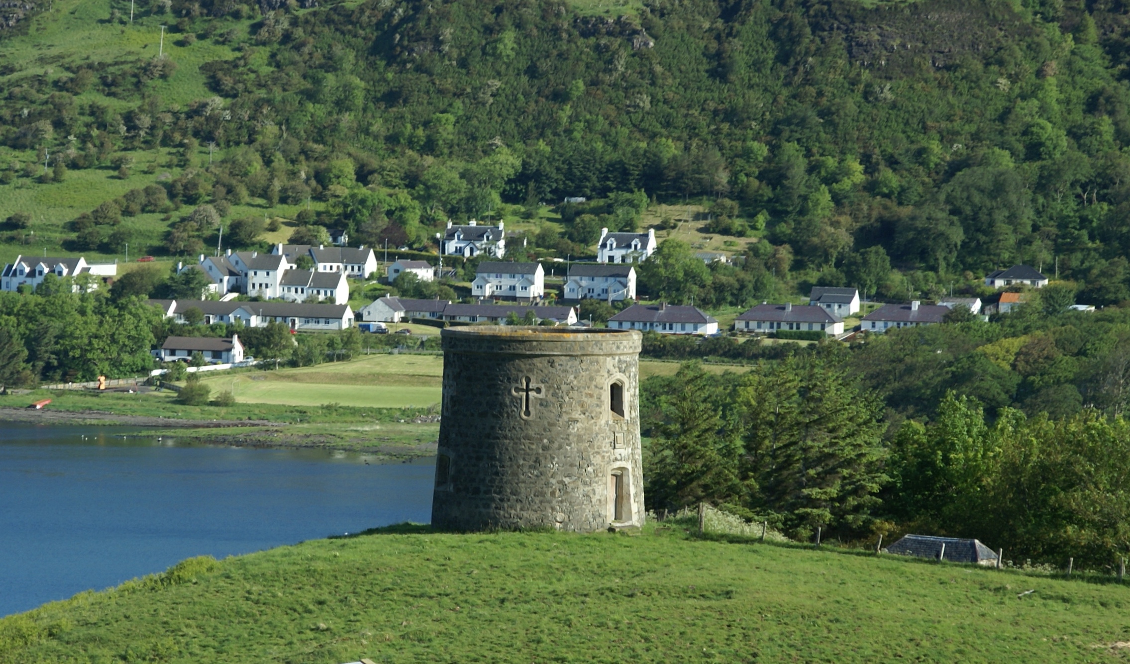
Uig Tower

The Uig Tower, also known as Captain Fraser's Folly, is a nineteenth century folly located in Uig on the island of Skye in the Highlands of Scotland. It...

Kingsburgh, Skye

Kingsburgh (Gaelic: Cinnseaborgh) is a scattered crofting township, overlooking Loch Snizort Beag on the Trotternish peninsula of the Isle of Skye in...

Nearby Amenities

Located within 500m of 57.548215,-6.38259
Created By: dmgroom_coastlines
Source: PGS
Lat/Long: 57.5494/-6.38978
Created By: dmgroom_coastlines
Source: PGS
Lat/Long: 57.54927/-6.38955
Created By: dmgroom_coastlines
Source: PGS
Lat/Long: 57.54914/-6.38932
Created By: dmgroom_coastlines
Source: PGS
Lat/Long: 57.54886/-6.38839
Created By: dmgroom_coastlines
Source: PGS
Lat/Long: 57.54859/-6.38746
Created By: dmgroom_coastlines
Source: PGS
Lat/Long: 57.54858/-6.38698
Source: PGS
Lat/Long: 57.548573/-6.3860643
Source: PGS
Lat/Long: 57.5487439/-6.3854226
Created By: dmgroom_coastlines
Source: PGS
Lat/Long: 57.54892/-6.38505
Source: PGS
Lat/Long: 57.5489297/-6.3844613
Created By: dmgroom_coastlines
Source: PGS
Lat/Long: 57.54878/-6.38411
Source: PGS
Lat/Long: 57.54851/-6.3838124
Created By: dmgroom_coastlines
Source: PGS
Lat/Long: 57.54812/-6.38344
Source: PGS
Lat/Long: 57.5479425/-6.3834035
Source: PGS
Lat/Long: 57.5477651/-6.3833162
Source: PGS
Lat/Long: 57.54615/-6.3829724
Source: PGS
Lat/Long: 57.5450716/-6.3835128
Source: PGS
Lat/Long: 57.5449243/-6.3834554
Source: PGS
Lat/Long: 57.5447663/-6.3833537
Created By: dmgroom_coastlines
Source: PGS
Lat/Long: 57.54453/-6.38322
Created By: dmgroom_coastlines
Source: PGS
Lat/Long: 57.54403/-6.38374
Created By: dmgroom_coastlines
Source: PGS
Lat/Long: 57.54377/-6.38376
Source: PGS
Lat/Long: 57.5440482/-6.3849704
Source: PGS
Lat/Long: 57.5443406/-6.3855499
Source: PGS
Lat/Long: 57.5447964/-6.3861064
Source: PGS
Lat/Long: 57.545224/-6.3864598
Source: PGS
Lat/Long: 57.5454297/-6.3873046
Source: PGS
Lat/Long: 57.5458288/-6.388344
Created By: dmgroom_coastlines
Source: PGS
Lat/Long: 57.54567/-6.38886
The data included in this document is from www.openstreetmap.org. The data is made available under ODbL.

Have you been to Cuidrach?

Leave your review of Cuidrach below (or comments, questions and feedback).