Kiln Wood

Wood, Forest in Northumberland

England

Kiln Wood

Codger Fort
Codger Fort Credit: Leanmeanmo

Kiln Wood, located in the picturesque region of Northumberland, is a captivating woodland area that spans over a vast expanse. Nestled amidst the rolling hills and dramatic landscapes, this woodland offers visitors a serene escape from the hustle and bustle of everyday life.

Covering an area of approximately 300 acres, Kiln Wood is home to a diverse range of flora and fauna. The wood is predominantly composed of deciduous trees, including oak, beech, and birch, which create a lush and vibrant canopy during the summer months. In the autumn, the woodland transforms into a kaleidoscope of colors as the leaves change, providing a breathtaking spectacle for nature enthusiasts.

The wood is crisscrossed by a network of well-maintained trails, making it an ideal destination for walkers, hikers, and nature lovers. These paths meander through the woodland, offering visitors the opportunity to explore the enchanting surroundings at their own pace. Along the way, one can encounter various species of birds, such as woodpeckers and owls, as well as small mammals like squirrels and rabbits.

Kiln Wood also boasts a rich historical background. The name "Kiln" originates from the ancient practice of charcoal burning that took place in this area during the medieval period. Remnants of the old kilns can still be found scattered throughout the wood, providing a glimpse into the past.

Overall, Kiln Wood, Northumberland, is a captivating forest that offers a tranquil retreat for those seeking solace in nature. Its stunning landscapes, diverse wildlife, and historical significance make it a must-visit destination for nature enthusiasts and history buffs alike.

If you have any feedback on the listing, please let us know in the comments section below.

Kiln Wood Images

Images are sourced within 2km of 55.215362/-1.9527743 or Grid Reference NZ0391. Thanks to Geograph Open Source API. All images are credited.

Codger Fort
Codger Fort
Codger Fort A folly eye-catcher?
Codger Fort
A folly eye-catcher?
Codger Fort Codger Fort was constructed by Sir Walter Blackett in the mid-eighteenth century.  See <span class="nowrap"><a title="http://www.castlesfortsbattles.co.uk/north_east/codger_fort.html" rel="nofollow ugc noopener" href="http://www.castlesfortsbattles.co.uk/north_east/codger_fort.html">Link</a><img style="margin-left:2px;" alt="External link" title="External link - shift click to open in new window" src="https://s1.geograph.org.uk/img/external.png" width="10" height="10"/></span> for further information on this prominent site above the B6342 near Rothley.

This photograph was taken during the Coronavirus (COVID-19) pandemic of 2020/21/22.
Codger Fort
Codger Fort was constructed by Sir Walter Blackett in the mid-eighteenth century. See LinkExternal link for further information on this prominent site above the B6342 near Rothley. This photograph was taken during the Coronavirus (COVID-19) pandemic of 2020/21/22.
Codger Fort atop the crags A view from the west of the impressive remains of Codger Fort.

This photograph was taken during the Coronavirus (COVID-19) pandemic of 2020/21/22.
Codger Fort atop the crags
A view from the west of the impressive remains of Codger Fort. This photograph was taken during the Coronavirus (COVID-19) pandemic of 2020/21/22.
Woodland by road
Woodland by road
Codger Fort This apparent ruin was a folly built by Sir William Blackett to resemble the remains of a border fort in the 18th century.
Codger Fort
This apparent ruin was a folly built by Sir William Blackett to resemble the remains of a border fort in the 18th century.
Rothley Shiel - youth hostel ruin Rothley Shiel was a tiny Northumberland Youth hostel opened in July 1949. The warden was Miss E Carmon. It was a very small wooden bungalow built as a shooting lodge, and named Wideopen Cottage on a recent OS map, but a ruin obliterated by vegetation in 2007. According to anecdote, it had no rear exit.
The youth hostel closed on the 8th April 1956 after only a short life. It would be interesting to know if it saw any other use before falling into disrepair.
Kindly contact if you have any tales of old British and Irish youth hostels such as this.
Rothley Shiel - youth hostel ruin
Rothley Shiel was a tiny Northumberland Youth hostel opened in July 1949. The warden was Miss E Carmon. It was a very small wooden bungalow built as a shooting lodge, and named Wideopen Cottage on a recent OS map, but a ruin obliterated by vegetation in 2007. According to anecdote, it had no rear exit. The youth hostel closed on the 8th April 1956 after only a short life. It would be interesting to know if it saw any other use before falling into disrepair. Kindly contact if you have any tales of old British and Irish youth hostels such as this.
Codger Fort Built by Sir Walter Blackett above the road between Rothbury and Scots Gap, Northumberland.
Codger Fort
Built by Sir Walter Blackett above the road between Rothbury and Scots Gap, Northumberland.
B6342 heading north Towards Rothbury.
B6342 heading north
Towards Rothbury.
Rough grazing near Rothley
Lane towards Rothley Shield West
Rothley Lake East To the east of the B6342.
Rothley Lake East
To the east of the B6342.
Rough grazing, Rothley Shield East The windmill is just north of the farm buildings at Rothley Shield East, see <a href="https://www.geograph.org.uk/photo/3657127">NZ0491 : Rough grazing land, Rothley Shield East</a>.
Rough grazing, Rothley Shield East
The windmill is just north of the farm buildings at Rothley Shield East, see NZ0491 : Rough grazing land, Rothley Shield East.
Rough grazing land, Rothley Shield East The windmill is by Rothley Shield East Farm, which just creeps into the edge of the square and the right of the picture. See also <a href="https://www.geograph.org.uk/photo/3657126">NZ0491 : Rough grazing, Rothley Shield East</a>.
Rough grazing land, Rothley Shield East
The windmill is by Rothley Shield East Farm, which just creeps into the edge of the square and the right of the picture. See also NZ0491 : Rough grazing, Rothley Shield East.
Rough grazing and plantation north of Rothley Shield East The trees were being buffeted by a strong wind on this stormy day which had spells of dazzling sunshine interspersed with dark skies and sudden showers.
Rough grazing and plantation north of Rothley Shield East
The trees were being buffeted by a strong wind on this stormy day which had spells of dazzling sunshine interspersed with dark skies and sudden showers.
Codger Fort (folly) in the snow This folly near Rothley stands overlooking the now tranquil Northumbrian countryside but is evocative of the more troubled times that plagued the Scottish-English border in the past.
Codger Fort (folly) in the snow
This folly near Rothley stands overlooking the now tranquil Northumbrian countryside but is evocative of the more troubled times that plagued the Scottish-English border in the past.
Approaching site of former Long Witton station, 2000 View southward on B4342 road at Rothley, ahead is the bridge over the trackbed of the ex-NBR (Reedsmouth) - Scotsgap - Rothbury branch. The station had been on the left, closure of line and station having occurred on 15/9/52 for passengers, 11/11/63 for goods.
Approaching site of former Long Witton station, 2000
View southward on B4342 road at Rothley, ahead is the bridge over the trackbed of the ex-NBR (Reedsmouth) - Scotsgap - Rothbury branch. The station had been on the left, closure of line and station having occurred on 15/9/52 for passengers, 11/11/63 for goods.
Old Milestone by the B6342, Donkin Rigg, Rothley parish Carved stone post by the B6342, in parish of Rothley (Alnwick District), Donkin Rigg, opposite track, on grass verge, on North side of road. Rothbury stone, erected by the Alemouth & Hexham, western part turnpike trust in the 18th century. 

Inscription reads:-
: R.B / 9 : : H / 22 :
Carved benchmark on left face.
(To Rothbury and Hexham)

Grade II listed. 
List Entry Number: 1155362 <span class="nowrap"><a title="https://historicengland.org.uk/listing/the-list/list-entry/1155362" rel="nofollow ugc noopener" href="https://historicengland.org.uk/listing/the-list/list-entry/1155362">Link</a><img style="margin-left:2px;" alt="External link" title="External link - shift click to open in new window" src="https://s1.geograph.org.uk/img/external.png" width="10" height="10"/></span>

Milestone Society National ID: NB_RBHX09
Old Milestone by the B6342, Donkin Rigg, Rothley parish
Carved stone post by the B6342, in parish of Rothley (Alnwick District), Donkin Rigg, opposite track, on grass verge, on North side of road. Rothbury stone, erected by the Alemouth & Hexham, western part turnpike trust in the 18th century. Inscription reads:- : R.B / 9 : : H / 22 : Carved benchmark on left face. (To Rothbury and Hexham) Grade II listed. List Entry Number: 1155362 LinkExternal link Milestone Society National ID: NB_RBHX09
Show me another place!

Kiln Wood is located at Grid Ref: NZ0391 (Lat: 55.215362, Lng: -1.9527743)

Unitary Authority: Northumberland

Police Authority: Northumbria

What 3 Words

///condense.enthused.assures. Near Rothley, Northumberland

Nearby Locations

Kiln Wood

Related Wikis

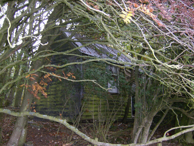
Longwitton railway station

Longwitton station was a weather board and corrugated iron built railway station in Northumberland on the Rothbury Branch. Originally known as Rothley...

Fallowlees Flush

Fallowlees Flush is the name given to a Site of Special Scientific Interest (SSSI) in mid-Northumberland, England. The steeply sloping site has calcium...
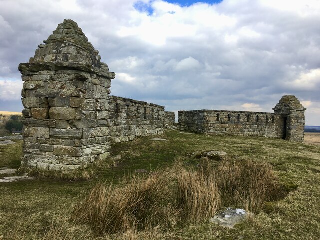
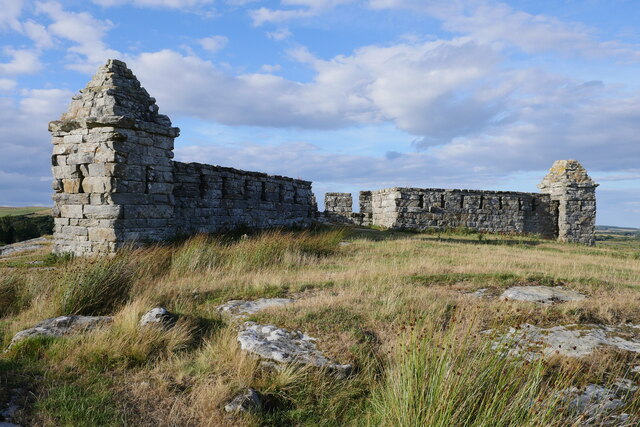
Rothley Castle

Rothley Castle is an 18th-century gothic folly built to resemble a medieval castle, situated at Rothley, Northumberland. It is a Grade II* listed building...

Ewesley railway station

Ewesley station was a weather board and corrugated iron built railway station in Northumberland on the Rothbury Branch built to serve the local farming...

Nearby Amenities

Located within 500m of 55.215362,-1.9527743
Barrier: cattle_grid
Lat/Long: 55.2178318/-1.9477264
Parking
Lat/Long: 55.2182884/-1.9476525
Barrier: cattle_grid
Lat/Long: 55.218208/-1.948169
The data included in this document is from www.openstreetmap.org. The data is made available under ODbL.

Have you been to Kiln Wood?

Leave your review of Kiln Wood below (or comments, questions and feedback).