Bickerton Wood

Wood, Forest in Northumberland

England

Bickerton Wood

Forest track below Simonside Although shown as a forest road on the OS map, this path has clearly been largely abandoned.
Forest track below Simonside Credit: Oliver Dixon

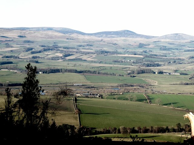
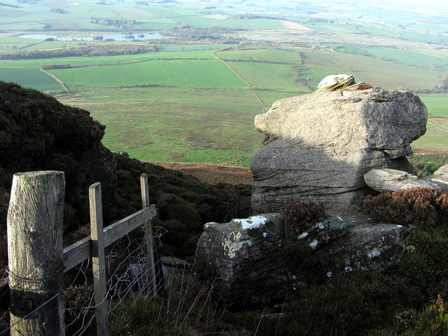
Bickerton Wood is a picturesque woodland located in Northumberland, England. Covering an area of approximately 100 acres, it is a popular destination for nature lovers, hikers, and birdwatchers. The wood is situated near the village of Bickerton, about 10 miles south-west of the town of Hexham.

The woodland is predominantly made up of broadleaf trees, including oak, beech, and ash. The dense canopy provides a cool and shaded environment, making it a pleasant place to escape the summer heat. The forest floor is covered in a carpet of wildflowers, with bluebells and primroses being particularly abundant during the spring.

Bickerton Wood is home to a diverse range of wildlife. Bird enthusiasts will be delighted to spot species such as woodpeckers, tits, and finches, while lucky visitors may even catch a glimpse of the elusive red squirrel. The wood is also teeming with various insects, butterflies, and small mammals.

Several walking trails crisscross the wood, allowing visitors to explore its beauty at their own pace. These paths lead through ancient trees, alongside babbling brooks, and up gentle slopes, providing stunning views of the surrounding countryside. Additionally, there are benches scattered throughout the wood, inviting visitors to sit and take in the tranquil surroundings.

Overall, Bickerton Wood offers a peaceful and enchanting experience for those seeking a connection with nature. Whether it is for a leisurely stroll, a picnic, or simply to enjoy the sights and sounds of the woodland, this beautiful forest in Northumberland is well worth a visit.

If you have any feedback on the listing, please let us know in the comments section below.

Bickerton Wood Images

Images are sourced within 2km of 55.29742/-1.9964122 or Grid Reference NU0000. Thanks to Geograph Open Source API. All images are credited.

Forest track below Simonside Although shown as a forest road on the OS map, this path has clearly been largely abandoned.
Forest track below Simonside
Although shown as a forest road on the OS map, this path has clearly been largely abandoned.
View over upper Coquetdale View from the slopes of Simonside over upper Coquetdale with the lake formed from an old gravel pit visible in the floor of the valley. Little Tosson Farm <a href="https://www.geograph.org.uk/gridref/NU0101">NU0101</a> is on this side of the lake. Cheviot Hills in the distance.
View over upper Coquetdale
View from the slopes of Simonside over upper Coquetdale with the lake formed from an old gravel pit visible in the floor of the valley. Little Tosson Farm NU0101 is on this side of the lake. Cheviot Hills in the distance.
A small cairn by the path to Tosson Hill
Gate at the top of the hill
Chesterhope Burn
Chesterhope Burn
Chester Hope Dippie Dixon in Upper Coquetdale (1903) records that locals would refer to Chester Hope as 'The Cheslips'.
Chester Hope
Dippie Dixon in Upper Coquetdale (1903) records that locals would refer to Chester Hope as 'The Cheslips'.
Boulder in forest plantation below Simonside Hills There used to be a path through here and I did manage to find it again higher up. On the lower slopes recent thinning of the forest has obliterated all traces and made my planned route very difficult.
Boulder in forest plantation below Simonside Hills
There used to be a path through here and I did manage to find it again higher up. On the lower slopes recent thinning of the forest has obliterated all traces and made my planned route very difficult.
Forest path below Kate & Geordie This path used to be maintained as a forest trail but is now hard to find and little used.
Forest path below Kate & Geordie
This path used to be maintained as a forest trail but is now hard to find and little used.
Kate & Geordie Two named rocks of natural outcrop in the forest on the north-west slope of Simonside Hills. They were so named on the First Edition OS Map of 1866, although Geordie is spelt with a 'y'.

Dippie Dixon in Upper Coquetdale (1903) suggests that the rocks, 'got their names during the hundred years the Donkins ruled at Tosson'. However, he does not inform us precisely who they relate to.

The author also describes the opening of a large cairn on Ravensheugh, 'just below' these two 'standing' stones. The kerbed cairn measured 27 feet from east to west and 30 feet north to south. Ten feet from its apex was a cist of four slabs of freestone with a massive capstone but with no trace of a burial. A cup marked stone was found in the excavation and illustrated. This cairn has not been subsequently located and is not shown on the OS map.
Kate & Geordie
Two named rocks of natural outcrop in the forest on the north-west slope of Simonside Hills. They were so named on the First Edition OS Map of 1866, although Geordie is spelt with a 'y'. Dippie Dixon in Upper Coquetdale (1903) suggests that the rocks, 'got their names during the hundred years the Donkins ruled at Tosson'. However, he does not inform us precisely who they relate to. The author also describes the opening of a large cairn on Ravensheugh, 'just below' these two 'standing' stones. The kerbed cairn measured 27 feet from east to west and 30 feet north to south. Ten feet from its apex was a cist of four slabs of freestone with a massive capstone but with no trace of a burial. A cup marked stone was found in the excavation and illustrated. This cairn has not been subsequently located and is not shown on the OS map.
Uppermost rock of Kate & Geordie I like to think this one is Kate.
Uppermost rock of Kate & Geordie
I like to think this one is Kate.
Lowermost rock of Kate & Geordie I like to think this one is Geordie.
Lowermost rock of Kate & Geordie
I like to think this one is Geordie.
Viewpoint north of Ravens Heugh
Simonside from Ravens Heugh
North-west from Ravens Heugh
Parish Boundary at Ravensheugh Crags
Boundary Stone, Ravens Heugh The stone is carved with an 'R' (Riddell) on the side away from Simonside, and an 'O' (Lord Oxford) on the opposite site. Recent clear felling of Harwood Forest beyond the moorland fence has opened up the view. The stone stands on the boundary between the parishes of Tosson and Hepple just south of Main Stone.
Northumberland Sites and Monuments Record (SMR): 12244
Boundary Stone, Ravens Heugh
The stone is carved with an 'R' (Riddell) on the side away from Simonside, and an 'O' (Lord Oxford) on the opposite site. Recent clear felling of Harwood Forest beyond the moorland fence has opened up the view. The stone stands on the boundary between the parishes of Tosson and Hepple just south of Main Stone. Northumberland Sites and Monuments Record (SMR): 12244
The Main Stone, Ravens Heugh A natural rock feature (described as a glacial erratic) marking a bend in the Parish Boundary between Hepple and Tosson. Dippie Dixon in Upper Coquetdale (1903) says it has also gone by the alias, Mere Stone, a 'mere' often meaning a boundary but it has never been marked as this on the OS maps.
Northumberland Sites and Monuments Record (SMR): 12243

There is another photo, taken before the forest was felled, here <a href="https://www.geograph.org.uk/photo/2059759">NZ0198 : The Main Stone, Ravens Heugh</a>
The Main Stone, Ravens Heugh
A natural rock feature (described as a glacial erratic) marking a bend in the Parish Boundary between Hepple and Tosson. Dippie Dixon in Upper Coquetdale (1903) says it has also gone by the alias, Mere Stone, a 'mere' often meaning a boundary but it has never been marked as this on the OS maps. Northumberland Sites and Monuments Record (SMR): 12243 There is another photo, taken before the forest was felled, here NZ0198 : The Main Stone, Ravens Heugh
The Main Stone, Ravens Heugh See the description here <a href="https://www.geograph.org.uk/photo/4228049">NZ0198 : The Main Stone, Ravens Heugh</a>
The Main Stone, Ravens Heugh
See the description here NZ0198 : The Main Stone, Ravens Heugh
Show me another place!

Bickerton Wood is located at Grid Ref: NU0000 (Lat: 55.29742, Lng: -1.9964122)

Unitary Authority: Northumberland

Police Authority: Northumbria

What 3 Words

///duplicity.making.owner. Near Rothbury, Northumberland

Nearby Locations

Bickerton Wood

Related Wikis

Reivers Way

The Reivers Way is a long-distance footpath in Northumberland, passing through the Northumberland National Park and the Cheviot Hills. Totalling 242 kilometres...

Hepple

Hepple is a small village and parish in rural Northumberland, 4 miles (6.4 km) west of Rothbury, which provides most of its local services. It is on the...

Tosson Hill

Tosson Hill is the highest hill in the Simonside Hills to the south of Rothbury in Northumberland, England. The summit lies about 2 kilometres (1.2 mi...

Simonside Hills

The Simonside Hills are a hill range in Northumberland, England near the town of Rothbury. Most of the hills are around 300–400 metres (980–1,310 ft) high...

Thropton

Thropton is a hamlet in Northumberland, England, located on the River Coquet, and its tributary Wreigh Burn. With a population of 458 (2011 census) it...

Snitter

Snitter is a village and civil parish in Northumberland, England. It is near the Northumberland National Park. The closest town is Rothbury. == Governance... ==

Cartington

Cartington is a village and former civil parish, now in the parish of Thropton, in Northumberland, England. It is about 11 miles (18 km) south west of...

Holystone, Northumberland

Holystone is a small village and former civil parish, now in the parish of Harbottle, in Northumberland, England. It lies on the edge of (and just within...

Have you been to Bickerton Wood?

Leave your review of Bickerton Wood below (or comments, questions and feedback).