Tolladine Wood

Wood, Forest in Worcestershire Worcester

England

Tolladine Wood

All that is left of the old Ronkswood hospital. Since the new Worcester Royal Hospital was built the old Ronkswood site has been levelled apart from this building which still carries communications antennae. Ronkswood was used during the 2nd world war for treating large numbers of injured soldiers.
All that is left of the old Ronkswood hospital. Credit: Richard Dunn

Tolladine Wood is a picturesque woodland located in Worcestershire, England. Covering an area of approximately 50 acres, this enchanting forest is a popular destination for nature enthusiasts and outdoor lovers.

The wood is characterized by its diverse range of trees, including oak, birch, and beech, which create a stunning canopy overhead. The forest floor is carpeted with a rich variety of wildflowers, adding to the wood's natural beauty. Tolladine Wood is also home to a variety of wildlife, including birds, squirrels, and deer, making it a haven for wildlife enthusiasts and birdwatchers.

The wood offers a network of well-maintained trails, allowing visitors to explore its tranquil surroundings. These paths wind their way through the forest, offering stunning views of the wood from different angles. There are also designated picnic areas and benches, providing visitors with the opportunity to relax and enjoy a peaceful lunch amidst nature.

Tolladine Wood is a popular spot for family outings and recreational activities. It offers a wide range of amenities to cater to visitors' needs, including parking facilities and well-maintained public toilets. The wood is also easily accessible, with good transport links and nearby accommodation options.

Overall, Tolladine Wood is a hidden gem in Worcestershire, offering a serene escape from the hustle and bustle of everyday life. Its natural beauty, diverse wildlife, and well-maintained trails make it an ideal destination for nature lovers and those seeking a peaceful retreat in the heart of the English countryside.

If you have any feedback on the listing, please let us know in the comments section below.

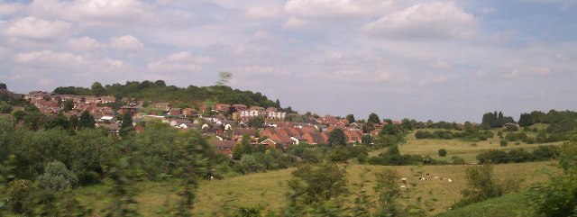
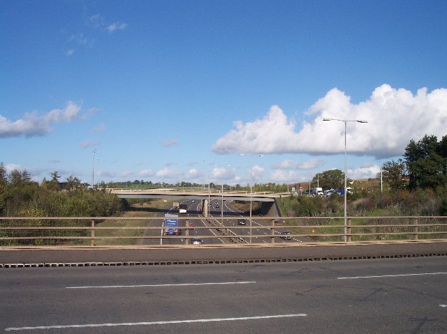
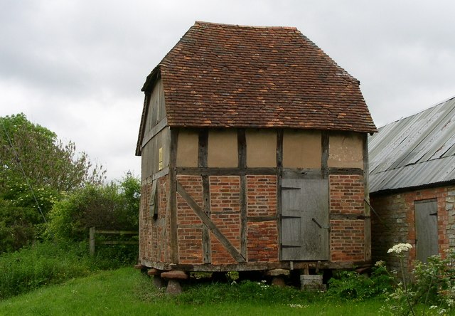
Tolladine Wood Images

Images are sourced within 2km of 52.20677/-2.1772412 or Grid Reference SO8756. Thanks to Geograph Open Source API. All images are credited.

All that is left of the old Ronkswood hospital. Since the new Worcester Royal Hospital was built the old Ronkswood site has been levelled apart from this building which still carries communications antennae. Ronkswood was used during the 2nd world war for treating large numbers of injured soldiers.
All that is left of the old Ronkswood hospital.
Since the new Worcester Royal Hospital was built the old Ronkswood site has been levelled apart from this building which still carries communications antennae. Ronkswood was used during the 2nd world war for treating large numbers of injured soldiers.
Ronkswood An open green space in Worcester.
Ronkswood
An open green space in Worcester.
Cummins Farm, Hindlip Cummins Farm lies just beyond the northern edge of the city of Worcester and near Hindlip Hall, headquarters of West Mercia Constabulary.
Cummins Farm, Hindlip
Cummins Farm lies just beyond the northern edge of the city of Worcester and near Hindlip Hall, headquarters of West Mercia Constabulary.
Blackpole East Industrial Estate north of Blackpole
Blackpole East
Industrial Estate north of Blackpole
Worcester Bosch Factory Units north of the B4639
Worcester Bosch
Factory Units north of the B4639
Worcester Canal Canal - looking east - one of the main canal links from Birmingham to the Severn navigation (although it doesn't look so major now!)
Worcester Canal
Canal - looking east - one of the main canal links from Birmingham to the Severn navigation (although it doesn't look so major now!)
Trotshill Roundabout One of the many roundabouts along the eastern relief road opening up the land between the city of Worcester and the M5 motorway for development into housing estates with attractive names like Long Meadow, The Lyppards and The Berkeleys.
Trotshill Roundabout
One of the many roundabouts along the eastern relief road opening up the land between the city of Worcester and the M5 motorway for development into housing estates with attractive names like Long Meadow, The Lyppards and The Berkeleys.
Woodgreen Evangelical Church A modern church for a modern housing estate crisscrossed with roads intersecting with roundabouts in the infill between the old city and the M5.
Woodgreen Evangelical Church
A modern church for a modern housing estate crisscrossed with roads intersecting with roundabouts in the infill between the old city and the M5.
Warndon Church Dedicated to St. Nicholas. originally a chapel to the manor house built around 1086. For more information see <span class="nowrap"><a title="http://www.warndon-stnicholas-worcester.org.uk/" rel="nofollow ugc noopener" href="http://www.warndon-stnicholas-worcester.org.uk/">Link</a><img style="margin-left:2px;" alt="External link" title="External link - shift click to open in new window" src="https://s1.geograph.org.uk/img/external.png" width="10" height="10"/></span>
Warndon Church
Dedicated to St. Nicholas. originally a chapel to the manor house built around 1086. For more information see LinkExternal link
M5  Junction 6  "Worcester North" A 6 road junction assisted by a huge roundabout above the motorway. Looking north up the M5 towards Birmingham.
M5 Junction 6 "Worcester North"
A 6 road junction assisted by a huge roundabout above the motorway. Looking north up the M5 towards Birmingham.
Pershore Lane Roundabout An upgrading of the old crossroads. Here Pershore Lane running from the M5 junction 6 to Pershore and Evesham crosses the B4636 into Worcester.
Pershore Lane Roundabout
An upgrading of the old crossroads. Here Pershore Lane running from the M5 junction 6 to Pershore and Evesham crosses the B4636 into Worcester.
Entrance to King George's Fields The gates are dated 1937 with Worcester's coat of arms complete with the three Black Pears. The left hand pillar is inscribed "George V AD 1910-1936" and the right hand pillar "King George's Fields". It is interesting to note that there is a similar entrance located at Campsie Crescent, Omagh with plaques on either side <a href="https://www.geograph.org.uk/photo/608540">H4572 : Entrance, King George V Field, Omagh</a>.
Entrance to King George's Fields
The gates are dated 1937 with Worcester's coat of arms complete with the three Black Pears. The left hand pillar is inscribed "George V AD 1910-1936" and the right hand pillar "King George's Fields". It is interesting to note that there is a similar entrance located at Campsie Crescent, Omagh with plaques on either side H4572 : Entrance, King George V Field, Omagh.
Court Farm,  Hindlip Part of the complex of farm buildings all currently empty.
For more on Hindlip see <span class="nowrap"><a title="http://www.users.totalise.co.uk/~fortroyal/WorcestershirePast/villages/hindlip.html" rel="nofollow ugc noopener" href="http://www.users.totalise.co.uk/~fortroyal/WorcestershirePast/villages/hindlip.html">Link</a><img style="margin-left:2px;" alt="External link" title="External link - shift click to open in new window" src="https://s1.geograph.org.uk/img/external.png" width="10" height="10"/></span>
Court Farm, Hindlip
Part of the complex of farm buildings all currently empty. For more on Hindlip see LinkExternal link
Worcestershire Royal Hospital I'm amazed nobody else has posted this. It's an impressive and important building in this square.
This place is work - all other images submitted by me are strictly pleasure.
Worcestershire Royal Hospital
I'm amazed nobody else has posted this. It's an impressive and important building in this square. This place is work - all other images submitted by me are strictly pleasure.
Trotshill Lane East Thursday 8th February 2007 15:09pm
Most snowfall here for many years.
Trotshill Lane East
Thursday 8th February 2007 15:09pm Most snowfall here for many years.
Worcestershire Royal Hospital The new PFI hospital is left of centre with the short white chimney. The site is shared with commercial office blocks that are behind the tree in the centre and right of centre. The tall chimneys above the right hand office block belong to the old Newtown Hospital - now known as Aconbury and part of WRH.
Worcestershire Royal Hospital
The new PFI hospital is left of centre with the short white chimney. The site is shared with commercial office blocks that are behind the tree in the centre and right of centre. The tall chimneys above the right hand office block belong to the old Newtown Hospital - now known as Aconbury and part of WRH.
Cattle Auction site, Worcester The old cattle market was near the old Worcester Royal Infirmary and this one is near the new Worcestershire Royal Hospital.
Cattle Auction site, Worcester
The old cattle market was near the old Worcester Royal Infirmary and this one is near the new Worcestershire Royal Hospital.
Charles Hastings Postgraduate Medical Education Centre This was built by private subscription and is run as a charitable institution on the Worcestershire Royal Hospital site. It includes an excellent medical museum and visits can be arranged.
Charles Hastings was a founder member of the Provincial Medical and Surgical Association and this later became the British Medical Association. This was founded in the old Castle Street WRI site and part at least is listed. Charles Hastings and his association is probably Worcester's greatest medical link.
Charles Hastings Postgraduate Medical Education Centre
This was built by private subscription and is run as a charitable institution on the Worcestershire Royal Hospital site. It includes an excellent medical museum and visits can be arranged. Charles Hastings was a founder member of the Provincial Medical and Surgical Association and this later became the British Medical Association. This was founded in the old Castle Street WRI site and part at least is listed. Charles Hastings and his association is probably Worcester's greatest medical link.
Show me another place!

Tolladine Wood is located at Grid Ref: SO8756 (Lat: 52.20677, Lng: -2.1772412)

Administrative County: Worcestershire

District: Worcester

Police Authority: West Mercia

What 3 Words

///ledge.wage.bleak. Near Fernhill Heath, Worcestershire

Nearby Locations

Tolladine Wood

Related Wikis

Warndon

Warndon is a suburb and civil parish of the City of Worcester in Worcestershire, England, located on the north eastern edge of the city. The parish, which...

Worcestershire

Worcestershire ( WUUST-ər-shər, -⁠sheer; written abbreviation: Worcs) is a ceremonial county in the West Midlands of England. It is bordered by Shropshire...

Sixways Stadium

Sixways Stadium is a stadium in Worcester, England. It is currently used for rugby union and association football matches and is the home stadium of Premier...

Worcester Raiders F.C.

Worcester Raiders Football Club is a football club based in Worcester, Worcestershire, England. They are currently members of the Hellenic League Premier...

Nearby Amenities

Located within 500m of 52.20677,-2.1772412
Mini Roundabout
Direction: clockwise
Lat/Long: 52.2058731/-2.1826459
Traffic Calming: hump
Lat/Long: 52.2069523/-2.1828642
Traffic Calming: chicane
Lat/Long: 52.20737/-2.1834179
Bus Stop
Borrowdale Drive
Bus: yes
Naptan AtcoCode: 2000G000707
Naptan Bearing: N
Naptan CommonName: Borrowdale Drive
Naptan Crossing: Borrowdale Drive
Naptan Indicator: opp
Naptan NaptanCode: wocgdajw
Naptan PlusbusZoneRef: WORCSFS
Naptan Street: Tolladine Road
Naptan Verified: no
Public Transport: platform
Shelter: yes
Source: naptan_import
Lat/Long: 52.2051107/-2.1829771
Bus Stop
Shap Drive
Bus: yes
Naptan AtcoCode: 2000G006400
Naptan Bearing: E
Naptan CommonName: Shap Drive
Naptan Crossing: Tolladine Road
Naptan Indicator: Adj
Naptan NaptanCode: wocgdjpa
Naptan PlusbusZoneRef: WORCSFS
Naptan Street: Shap Drive
Naptan Verified: no
Public Transport: platform
Source: naptan_import
Lat/Long: 52.2082875/-2.1809853
Bus Stop
Prince Of Wales Inn
Bus: yes
Naptan AtcoCode: 2000G007202
Naptan Bearing: N
Naptan CommonName: Prince Of Wales Inn
Naptan Indicator: adj
Naptan Landmark: Prince of Wales Inn
Naptan NaptanCode: wocgawaj
Naptan PlusbusZoneRef: WORCSFS
Naptan Street: Windermere Drive
Naptan Verified: no
Public Transport: platform
Source: naptan_import
Lat/Long: 52.2062531/-2.1826453
Bus Stop
Tamworth Avenue
Bus: yes
Naptan AtcoCode: 2000G007900
Naptan Bearing: E
Naptan CommonName: Tamworth Avenue
Naptan Indicator: Adj
Naptan Landmark: Tamworth Avenue
Naptan NaptanCode: wocgdtja
Naptan PlusbusZoneRef: WORCSFS
Naptan Street: Hastings Drive
Naptan Verified: no
Public Transport: platform
Source: naptan_import
Lat/Long: 52.2084066/-2.1735075
Bus Stop
Debdale Avenue
Bench: no
Bin: no
Bus: yes
Naptan AtcoCode: 2000G008300
Naptan Bearing: N
Naptan CommonName: Debdale Avenue
Naptan Indicator: Adj
Naptan Landmark: Debdale Avenue
Naptan NaptanCode: wocgdwdw
Naptan PlusbusZoneRef: WORCSFS
Naptan Street: Millwood Drive
Naptan Verified: no
Public Transport: platform
Shelter: no
Source: naptan_import
Lat/Long: 52.2052279/-2.1768754
Bus Stop
Tolladine Wood
Bench: yes
Bus: yes
Naptan AtcoCode: 2000G008301
Naptan Bearing: SW
Naptan CommonName: Tolladine Wood
Naptan Indicator: Adj
Naptan Landmark: Tolladine Wood
Naptan NaptanCode: wocgdwga
Naptan PlusbusZoneRef: WORCSFS
Naptan Street: Wood Green Drive
Naptan Verified: no
Public Transport: platform
Shelter: yes
Source: naptan_import
Tactile Paving: no
Lat/Long: 52.2064952/-2.1784519
Bus Stop
Middle Hollow Drive
Bench: no
Bin: yes
Bus: yes
Lit: yes
Naptan AtcoCode: 2000G008405
Naptan Bearing: N
Naptan CommonName: Middle Hollow Drive
Naptan Crossing: Middle Hollow Drive
Naptan Indicator: Adj
Naptan NaptanCode: wocgdwgt
Naptan PlusbusZoneRef: WORCSFS
Naptan Street: Woodgreen Drive
Naptan Verified: no
Public Transport: platform
Shelter: no
Source: naptan_import
Tactile Paving: no
Lat/Long: 52.204007/-2.1815825
Bus Stop
Wall Meadow
Bench: yes
Bin: no
Bus: yes
Naptan AtcoCode: 2000G008407
Naptan Bearing: N
Naptan CommonName: Wall Meadow
Naptan Indicator: Adj
Naptan NaptanCode: wocgdwja
Naptan PlusbusZoneRef: WORCSFS
Naptan Street: Woodgreen Drive
Naptan Verified: no
Public Transport: platform
Shelter: yes
Source: naptan_import
Lat/Long: 52.2106853/-2.1791538
Bus Stop
Wall Meadow
Bus: yes
Naptan AtcoCode: 2000G008408
Naptan Bearing: N
Naptan CommonName: Wall Meadow
Naptan Indicator: Opp
Naptan NaptanCode: wocgdwjd
Naptan PlusbusZoneRef: WORCSFS
Naptan Street: Woodgreen Drive
Naptan Verified: no
Public Transport: platform
Source: naptan_import
Lat/Long: 52.2103423/-2.1786757
Bus Stop
Haywain Avenue
Bus: yes
Naptan AtcoCode: 2000G323041
Naptan Bearing: E
Naptan CommonName: Haywain Avenue
Naptan Indicator: opp
Naptan Landmark: Huxley
Naptan NaptanCode: wocdwpgj
Naptan PlusbusZoneRef: WORCSFS
Naptan Street: Plantation Drive
Naptan Verified: no
Public Transport: platform
Source: naptan_import
Lat/Long: 52.2058523/-2.174156
Bus Stop
Haywain Avenue
Bus: yes
Naptan AtcoCode: 2000G323941
Naptan Bearing: W
Naptan CommonName: Haywain Avenue
Naptan Indicator: adj
Naptan Landmark: Huxley
Naptan NaptanCode: wocdpdtg
Naptan PlusbusZoneRef: WORCSFS
Naptan Street: Plantation Drive
Naptan Verified: no
Public Transport: platform
Source: naptan_import
Lat/Long: 52.2057619/-2.1745362
Bus Stop
Saltwood Avenue
Bench: yes
Bin: yes
Bus: yes
Departures Board: timetable
Lit: yes
Naptan AtcoCode: 2000G500995
Naptan Bearing: W
Naptan BusStopType: CUS
Naptan CommonName: Saltwood Avenue
Naptan Indicator: Adj
Naptan Landmark: Saltwood Avenue
Naptan NaptanCode: wocdwgwg
Naptan PlusbusZoneRef: WORCSFS
Naptan Street: Hastings Drive
Naptan Verified: no
Operator: First Bus
Public Transport: platform
Shelter: yes
Source: naptan_import
Tactile Paving: no
Lat/Long: 52.2086147/-2.1763883
Bus Stop
Tamworth Avenue
Bus: yes
Naptan AtcoCode: 2000G500996
Naptan Bearing: W
Naptan BusStopType: CUS
Naptan CommonName: Tamworth Avenue
Naptan Indicator: Opp
Naptan Landmark: Tamworth Avenue
Naptan NaptanCode: wocdwgwj
Naptan PlusbusZoneRef: WORCSFS
Naptan Street: Hastings Drive
Naptan Verified: no
Public Transport: platform
Source: naptan_import
Lat/Long: 52.2082898/-2.1734632
Bus Stop
Tolladine Wood
Bench: no
Bin: yes
Bus: yes
Lit: yes
Naptan AtcoCode: 2000G501917
Naptan Bearing: NE
Naptan CommonName: Tolladine Wood
Naptan Indicator: Opp
Naptan Landmark: Tolladine Wood
Naptan NaptanCode: wocgjagj
Naptan PlusbusZoneRef: WORCSFS
Naptan Street: Woodgreen Drive
Naptan Verified: no
Public Transport: platform
Shelter: no
Source: naptan_import
Tactile Paving: no
Lat/Long: 52.2070329/-2.1783021
Bus Stop
Prince of Wales Inn
Bus: yes
Naptan AtcoCode: 2000G501950
Naptan Bearing: S
Naptan BusStopType: CUS
Naptan CommonName: Prince of Wales Inn
Naptan Indicator: opp
Naptan Landmark: Prince of Wales Inn
Naptan NaptanCode: wocgjajd
Naptan PlusbusZoneRef: WORCSFS
Naptan Street: Windermere Drive
Naptan Verified: no
Public Transport: platform
Source: naptan_import
Lat/Long: 52.2065321/-2.1825147
Bus Stop
Debdale Avenue
Bench: no
Bin: yes
Bus: yes
Naptan AtcoCode: 2000G590001
Naptan Bearing: S
Naptan CommonName: Debdale Avenue
Naptan Indicator: Opp
Naptan Landmark: Debdale Avenue
Naptan NaptanCode: wocdgajm
Naptan PlusbusZoneRef: WORCSFS
Naptan Street: Millwood Drive
Naptan Verified: no
Public Transport: platform
Shelter: yes
Source: naptan_import
Lat/Long: 52.205444/-2.1766861
Crossing
Crossing: unmarked
Crossing Island: yes
Kerb: lowered
Tactile Paving: no
Lat/Long: 52.2058341/-2.1789966
Barrier: cycle_barrier
Lat/Long: 52.2085108/-2.1773982
Crossing
Crossing: unmarked
Crossing Island: no
Kerb: lowered
Tactile Paving: no
Lat/Long: 52.2051711/-2.1784607
Post Box
Collection Times: Mo-Fr 16:45; Sa 11:30
Post Box Type: pillar
Ref: WR4 515
Royal Cypher: EIIR
Royal Cypher Wikidata: Q33102113
Lat/Long: 52.2086898/-2.1760791
Barrier: cycle_barrier
Lat/Long: 52.2083977/-2.1745735
Waste Basket
Waste: dog_excrement
Lat/Long: 52.2087069/-2.175998
Barrier: cycle_barrier
Lat/Long: 52.208548/-2.174564
Barrier: cattle_grid
Lat/Long: 52.2094974/-2.1733389
Barrier: cattle_grid
Lat/Long: 52.2091185/-2.1741954
Barrier: cattle_grid
Lat/Long: 52.209659/-2.1740086
Post Box
Check Date: 2021-02-10
Collection Times: Mo-Fr 09:00, Sa 07:00
Post Box Type: pillar
Ref: WR4 474
Royal Cypher: EIIR
Royal Cypher Wikidata: Q33102113
Source: GPS Survey
Lat/Long: 52.2035904/-2.176548
Post Box
Collection Times: Mo-Fr 17:00; Sa 11:30
Post Box Type: lamp
Ref: WR4 473
Royal Cypher: EIIR
Royal Cypher Wikidata: Q33102113
Source: GPS Survey
Lat/Long: 52.2071075/-2.1832883
Post Box
Collection Times: Mo-Fr 16:45; Sa 11:30
Post Box Type: lamp
Ref: WR4 450
Royal Cypher: EIIR
Royal Cypher Wikidata: Q33102113
Source: GPS Survey
Lat/Long: 52.2078832/-2.1807632
Give Way
Direction: backward
Lat/Long: 52.2074956/-2.1836755
Generator Method: photovoltaic
Generator Output Electricity: yes
Generator Source: solar
Generator Type: solar_photovoltaic_panel
Location: roof
Power: generator
Lat/Long: 52.2074472/-2.1752849
Generator Method: photovoltaic
Generator Output Electricity: yes
Generator Source: solar
Generator Type: solar_photovoltaic_panel
Location: roof
Power: generator
Lat/Long: 52.2069771/-2.1751106
Generator Method: photovoltaic
Generator Output Electricity: yes
Generator Source: solar
Generator Type: solar_photovoltaic_panel
Location: roof
Power: generator
Lat/Long: 52.2069722/-2.1749952
Generator Method: photovoltaic
Generator Output Electricity: yes
Generator Source: solar
Generator Type: solar_photovoltaic_panel
Location: roof
Power: generator
Lat/Long: 52.2068078/-2.1736407
Generator Method: photovoltaic
Generator Output Electricity: yes
Generator Source: solar
Generator Type: solar_photovoltaic_panel
Location: roof
Power: generator
Lat/Long: 52.2061487/-2.1708673
Generator Method: photovoltaic
Generator Output Electricity: yes
Generator Source: solar
Generator Type: solar_photovoltaic_panel
Location: roof
Power: generator
Lat/Long: 52.2061652/-2.1707118
Crossing
Kerb: lowered
Lat/Long: 52.2071828/-2.1780508
Generator Method: photovoltaic
Generator Output Electricity: yes
Generator Source: solar
Generator Type: solar_photovoltaic_panel
Location: roof
Power: generator
Lat/Long: 52.208177/-2.1820682
Generator Method: photovoltaic
Generator Output Electricity: yes
Generator Source: solar
Generator Type: solar_photovoltaic_panel
Location: roof
Power: generator
Lat/Long: 52.2081639/-2.1819623
Generator Method: photovoltaic
Generator Output Electricity: yes
Generator Source: solar
Generator Type: solar_photovoltaic_panel
Location: roof
Power: generator
Lat/Long: 52.2048078/-2.1776305
Generator Method: photovoltaic
Generator Output Electricity: yes
Generator Source: solar
Generator Type: solar_photovoltaic_panel
Location: roof
Power: generator
Lat/Long: 52.2039839/-2.1778464
Generator Method: photovoltaic
Generator Output Electricity: yes
Generator Source: solar
Generator Type: solar_photovoltaic_panel
Location: roof
Power: generator
Lat/Long: 52.2039075/-2.1787114
Generator Method: photovoltaic
Generator Output Electricity: yes
Generator Source: solar
Generator Type: solar_photovoltaic_panel
Location: roof
Power: generator
Lat/Long: 52.2081852/-2.1789676
Generator Method: photovoltaic
Generator Output Electricity: yes
Generator Source: solar
Generator Type: solar_photovoltaic_panel
Location: roof
Power: generator
Lat/Long: 52.2043242/-2.1814379
Generator Method: photovoltaic
Generator Output Electricity: yes
Generator Source: solar
Generator Type: solar_photovoltaic_panel
Location: roof
Power: generator
Lat/Long: 52.2071645/-2.1793833
Generator Method: photovoltaic
Generator Output Electricity: yes
Generator Source: solar
Generator Type: solar_photovoltaic_panel
Location: roof
Power: generator
Lat/Long: 52.2071382/-2.1792251
Generator Method: photovoltaic
Generator Output Electricity: yes
Generator Source: solar
Generator Type: solar_photovoltaic_panel
Location: roof
Power: generator
Lat/Long: 52.2071284/-2.1790668
Generator Method: photovoltaic
Generator Output Electricity: yes
Generator Source: solar
Generator Type: solar_photovoltaic_panel
Location: roof
Power: generator
Lat/Long: 52.2095297/-2.1796703
Generator Method: photovoltaic
Generator Output Electricity: yes
Generator Source: solar
Generator Type: solar_photovoltaic_panel
Location: roof
Power: generator
Lat/Long: 52.2097828/-2.1786189
Generator Method: photovoltaic
Generator Output Electricity: yes
Generator Source: solar
Generator Type: solar_photovoltaic_panel
Location: roof
Power: generator
Lat/Long: 52.2094705/-2.1784848
Generator Method: photovoltaic
Generator Output Electricity: yes
Generator Source: solar
Generator Type: solar_photovoltaic_panel
Location: roof
Power: generator
Lat/Long: 52.2092503/-2.1782836
Generator Method: photovoltaic
Generator Output Electricity: yes
Generator Source: solar
Generator Type: solar_photovoltaic_panel
Location: roof
Power: generator
Lat/Long: 52.2092618/-2.1781978
Generator Method: photovoltaic
Generator Output Electricity: yes
Generator Source: solar
Generator Type: solar_photovoltaic_panel
Location: roof
Power: generator
Lat/Long: 52.2069985/-2.1760842
Generator Method: photovoltaic
Generator Output Electricity: yes
Generator Source: solar
Generator Type: solar_photovoltaic_panel
Location: roof
Power: generator
Lat/Long: 52.2065547/-2.1700385
Generator Method: photovoltaic
Generator Output Electricity: yes
Generator Source: solar
Generator Type: solar_photovoltaic_panel
Location: roof
Power: generator
Lat/Long: 52.2092717/-2.1731016
Generator Method: photovoltaic
Generator Output Electricity: yes
Generator Source: solar
Generator Type: solar_photovoltaic_panel
Location: roof
Power: generator
Lat/Long: 52.2097878/-2.173917
Generator Method: photovoltaic
Generator Output Electricity: yes
Generator Source: solar
Generator Type: solar_photovoltaic_panel
Location: roof
Power: generator
Lat/Long: 52.204394/-2.1740833
Barrier: block
Lat/Long: 52.209418/-2.18042
Crossing
Crossing: traffic_signals
Crossing Island: yes
Lat/Long: 52.2109974/-2.1792268
Waste: trash
Lat/Long: 52.210748/-2.1800077
Addr Housenumber: 1
Addr Postcode: WR4 0DQ
Addr Street: Hever Avenue
Survey Date: 2020-06-22
Lat/Long: 52.2077592/-2.1721112
Addr Housenumber: 22
Addr Postcode: WR4 0JP
Addr Street: Saltwood Avenue
Survey Date: 2020-06-22
Lat/Long: 52.2074425/-2.1753133
Addr Housenumber: 20
Addr Postcode: WR4 0JP
Addr Street: Saltwood Avenue
Survey Date: 2020-06-22
Lat/Long: 52.2075243/-2.1754387
Addr Housenumber: 1
Addr Street: Kendal Green
Survey Date: 2020-06-26
Lat/Long: 52.2084665/-2.1836707
Addr Housenumber: 1
Addr Street: Cartmel Close
Survey Date: 2020-06-26
Lat/Long: 52.2082367/-2.1823802
Addr Housenumber: 2
Addr Street: Cartmel Close
Survey Date: 2020-06-26
Lat/Long: 52.2082768/-2.1828044
Bench
Backrest: yes
Inscription: In Memory of John Downer 1998
Lat/Long: 52.2064544/-2.17837
Board Type: nature;history
Information: board
Tourism: information
Lat/Long: 52.2071455/-2.1777155
Generator Method: photovoltaic
Generator Output Electricity: yes
Generator Source: solar
Generator Type: solar_photovoltaic_panel
Location: roof
Power: generator
Lat/Long: 52.2089709/-2.181395
Generator Method: photovoltaic
Generator Output Electricity: yes
Generator Source: solar
Generator Type: solar_photovoltaic_panel
Location: roof
Power: generator
Lat/Long: 52.2084564/-2.1820951
Generator Method: photovoltaic
Generator Output Electricity: yes
Generator Source: solar
Generator Type: solar_photovoltaic_panel
Location: roof
Power: generator
Lat/Long: 52.2084482/-2.1819958
Generator Method: photovoltaic
Generator Output Electricity: yes
Generator Source: solar
Generator Type: solar_photovoltaic_panel
Location: roof
Power: generator
Lat/Long: 52.2084153/-2.1814567
Generator Method: photovoltaic
Generator Output Electricity: yes
Generator Source: solar
Generator Type: solar_photovoltaic_panel
Location: roof
Power: generator
Lat/Long: 52.209699/-2.1789086
Generator Method: photovoltaic
Generator Output Electricity: yes
Generator Source: solar
Generator Type: solar_photovoltaic_panel
Location: roof
Power: generator
Lat/Long: 52.2094064/-2.1756336
Generator Method: photovoltaic
Generator Output Electricity: yes
Generator Source: solar
Generator Type: solar_photovoltaic_panel
Location: roof
Power: generator
Lat/Long: 52.2033642/-2.1760306
Generator Method: photovoltaic
Generator Output Electricity: yes
Generator Source: solar
Generator Type: solar_photovoltaic_panel
Location: roof
Power: generator
Lat/Long: 52.2050688/-2.1720046
Generator Method: photovoltaic
Generator Output Electricity: yes
Generator Source: solar
Generator Type: solar_photovoltaic_panel
Location: roof
Power: generator
Lat/Long: 52.2031209/-2.1790266
Generator Method: photovoltaic
Generator Output Electricity: yes
Generator Source: solar
Generator Type: solar_photovoltaic_panel
Location: roof
Power: generator
Lat/Long: 52.2051214/-2.1734476
Generator Method: photovoltaic
Generator Output Electricity: yes
Generator Source: solar
Generator Type: solar_photovoltaic_panel
Location: roof
Power: generator
Lat/Long: 52.204883/-2.1728253
Generator Method: photovoltaic
Generator Output Electricity: yes
Generator Source: solar
Generator Type: solar_photovoltaic_panel
Location: roof
Power: generator
Lat/Long: 52.2069624/-2.1708056
Marker: pedestal
Utility: gas
Lat/Long: 52.2083134/-2.1800633
Marker: pedestal
Utility: gas
Lat/Long: 52.2097559/-2.178447
Marker: pedestal
Operator: CLH
Operator Old: GPSS
Ref: MP 1964
Utility: oil
Lat/Long: 52.2049784/-2.1834388
Backrest: no
Bench: yes
Lat/Long: 52.2054946/-2.1713311
Marker: pedestal
Operator: CLH
Operator Old: GPSS
Ref: MP 1965
Utility: oil
Lat/Long: 52.2071927/-2.1832313
Marker: pedestal
Operator: CLH
Operator Old: GPSS
Ref: MP 1799
Utility: oil
Lat/Long: 52.2057797/-2.1827844
The data included in this document is from www.openstreetmap.org. The data is made available under ODbL.

Have you been to Tolladine Wood?

Leave your review of Tolladine Wood below (or comments, questions and feedback).