An Crìonan

Settlement in Argyllshire

Scotland

An Crìonan

VIC 32 at Crinan Basin VIC 32 is a prominent vessel in Crinan Basin.  For further information on this Clyde 'puffer', see <span class="nowrap"><a title="http://savethepuffer.co.uk/history-of-vic-32/" rel="nofollow ugc noopener" href="http://savethepuffer.co.uk/history-of-vic-32/">Link</a><img style="margin-left:2px;" alt="External link" title="External link - shift click to open in new window" src="https://s1.geograph.org.uk/img/external.png" width="10" height="10"/></span> 

This photograph was taken during the Coronavirus (COVID-19) pandemic of 2020/21.
VIC 32 at Crinan Basin Credit: James T M Towill

An Crìonan is a small village located in Argyllshire, Scotland. Situated on the west coast of the country, it is surrounded by stunning natural beauty, including the rugged hills and picturesque lochs that the region is renowned for.

The village itself is characterized by its peaceful and idyllic atmosphere. It is home to a close-knit community, with a population of around 200 residents. The houses in An Crìonan are typically traditional, reflecting the local architectural style.

Despite its small size, An Crìonan offers a range of amenities for its residents. There is a local primary school, providing education for the village's children, as well as a community center that serves as a hub for social activities. A nearby grocery store caters to the daily needs of the villagers, ensuring they have access to essential supplies.

The village's location makes it an ideal base for outdoor enthusiasts. The surrounding area is perfect for hiking, with numerous trails offering breathtaking views of the Scottish countryside. Fishing is also popular, thanks to the nearby lochs that are abundant with trout and salmon.

For those seeking a peaceful retreat away from the hustle and bustle of city life, An Crìonan provides a charming and tranquil escape. Its natural beauty, combined with the warmth and friendliness of the local community, make it a truly special place to visit or call home.

If you have any feedback on the listing, please let us know in the comments section below.

An Crìonan Images

Images are sourced within 2km of 56.086281/-5.560194 or Grid Reference NR7893. Thanks to Geograph Open Source API. All images are credited.

VIC 32 at Crinan Basin VIC 32 is a prominent vessel in Crinan Basin.  For further information on this Clyde 'puffer', see <span class="nowrap"><a title="http://savethepuffer.co.uk/history-of-vic-32/" rel="nofollow ugc noopener" href="http://savethepuffer.co.uk/history-of-vic-32/">Link</a><img style="margin-left:2px;" alt="External link" title="External link - shift click to open in new window" src="https://s1.geograph.org.uk/img/external.png" width="10" height="10"/></span> 

This photograph was taken during the Coronavirus (COVID-19) pandemic of 2020/21.
VIC 32 at Crinan Basin
VIC 32 is a prominent vessel in Crinan Basin. For further information on this Clyde 'puffer', see LinkExternal link This photograph was taken during the Coronavirus (COVID-19) pandemic of 2020/21.
Crinan Bridge in the early August sunshine The Cairnbaan to Crinan section of the Crinan Canal is particularly scenic, as exemplified by this shot of the Crinan (swing) Bridge.

This photograph was taken during the Coronavirus (COVID-19) pandemic of 2020/21.
Crinan Bridge in the early August sunshine
The Cairnbaan to Crinan section of the Crinan Canal is particularly scenic, as exemplified by this shot of the Crinan (swing) Bridge. This photograph was taken during the Coronavirus (COVID-19) pandemic of 2020/21.
A mix of boats in Crinan Basin Bypassing the strong tides and potentially rough seas of the Mull of Kintyre is important to anyone in a small boat, whether a pleasure vessel,  a fishing boat, or a Clyde Puffer carrying cargo (though very few of those are left). Boats moored in the basin at the Crinan end of the Crinan Canal reflect this mix. The final lock on the canal connects this basin to the open sea, but most travellers will wait for the tide to exit the canal, not just to have enough water under the keel but also to avoid being swept through the Dorus Mor and potentially into the Gulf of Corryvreckan by the notoriously strong tides in the Sound of Jura.
A mix of boats in Crinan Basin
Bypassing the strong tides and potentially rough seas of the Mull of Kintyre is important to anyone in a small boat, whether a pleasure vessel, a fishing boat, or a Clyde Puffer carrying cargo (though very few of those are left). Boats moored in the basin at the Crinan end of the Crinan Canal reflect this mix. The final lock on the canal connects this basin to the open sea, but most travellers will wait for the tide to exit the canal, not just to have enough water under the keel but also to avoid being swept through the Dorus Mor and potentially into the Gulf of Corryvreckan by the notoriously strong tides in the Sound of Jura.
Heading west past Ardnoe Point It's rare that those on the sea feel threatened by low cloud, but it was a dull and dismal July day when we left Crinan heading down the Sound of Jura for a two day trip and visibility was potentially an issue. We're just picking some assistance from the ebb tide, but out in the channel towards Ruadh Sgeir, it was already starting to move quite fast, so the potential for rough water in poor visibility kept us close inshore for most of the day.
Heading west past Ardnoe Point
It's rare that those on the sea feel threatened by low cloud, but it was a dull and dismal July day when we left Crinan heading down the Sound of Jura for a two day trip and visibility was potentially an issue. We're just picking some assistance from the ebb tide, but out in the channel towards Ruadh Sgeir, it was already starting to move quite fast, so the potential for rough water in poor visibility kept us close inshore for most of the day.
Heading south from Ardnoe Point It's rare that those on the sea feel threatened by low cloud, but it was a dull and dismal July day when we left Crinan heading down the Sound of Jura for a two day trip and visibility was potentially an issue. We're just picking some assistance from the ebb tide, but out in the channel towards Ruadh Sgeir, it was already starting to move quite fast, so the potential for rough water in poor visibility kept us close inshore for most of the day.
Heading south from Ardnoe Point
It's rare that those on the sea feel threatened by low cloud, but it was a dull and dismal July day when we left Crinan heading down the Sound of Jura for a two day trip and visibility was potentially an issue. We're just picking some assistance from the ebb tide, but out in the channel towards Ruadh Sgeir, it was already starting to move quite fast, so the potential for rough water in poor visibility kept us close inshore for most of the day.
Two puffers at Crinan, 1998 – 1 VIC32 and VIC27 (aka “Vital Spark”) moored together in the basin.
Two puffers at Crinan, 1998 – 1
VIC32 and VIC27 (aka “Vital Spark”) moored together in the basin.
Two puffers at Crinan, 1998 – 2 VIC32 and VIC27 (aka “Vital Spark”) moored together in the basin.
Two puffers at Crinan, 1998 – 2
VIC32 and VIC27 (aka “Vital Spark”) moored together in the basin.
The basin at Crinan, 1998 To the left are the two puffers, VIC27 (aka “Vital Spark”) and VIC32, with commercial inshore fishing craft to the right.
The basin at Crinan, 1998
To the left are the two puffers, VIC27 (aka “Vital Spark”) and VIC32, with commercial inshore fishing craft to the right.
Welcome to Crinan Sea Lock, 1998 The western entrance to the Crinan Canal. The concrete pier in the foreground is part of a later rebuilding of the original lock of c.1800, the stonework of which can be seen beyond. The whole of the Canal and its structures is covered by a series of Scheduled Monument designations, rather than being Listed.
Welcome to Crinan Sea Lock, 1998
The western entrance to the Crinan Canal. The concrete pier in the foreground is part of a later rebuilding of the original lock of c.1800, the stonework of which can be seen beyond. The whole of the Canal and its structures is covered by a series of Scheduled Monument designations, rather than being Listed.
Two puffers at Crinan, 1998 – 3 VIC32 and VIC27 (aka “Vital Spark”) moored together in the basin.
Two puffers at Crinan, 1998 – 3
VIC32 and VIC27 (aka “Vital Spark”) moored together in the basin.
B8025 towards Tayvallich
Crinan Canal
Crinan Canal
Crinan Canal basin
Crinan Canal basin
Swing-bridge, Crinan Canal
Sandbanks and saltmarsh of the Add estuary
Leac na Ban The house and outbuildings at Leac na Ban.
Leac na Ban
The house and outbuildings at Leac na Ban.
Track from Bellanoch to Leac na Ban
Clear fell above Bellanoch
Show me another place!

An Crìonan is located at Grid Ref: NR7893 (Lat: 56.086281, Lng: -5.560194)

Unitary Authority: Argyll and Bute

Police Authority: Argyll and West Dunbartonshire

Also known as: Crinan

What 3 Words

///disposing.approvals.teardrop. Near Lochgilphead, Argyll & Bute

Related Wikis

Crinan, Argyll

Crinan (Scottish Gaelic: An Crìonan) is a small village located on the west coast of Scotland in the region known as Knapdale, which is part of Argyll...

Eilean dà Mhèinn

Eilean dà Mhèinn, is a small inhabited island in Loch Crinan and one of the Inner Hebrides of Scotland. It is about 100 metres (330 ft) to the west of...
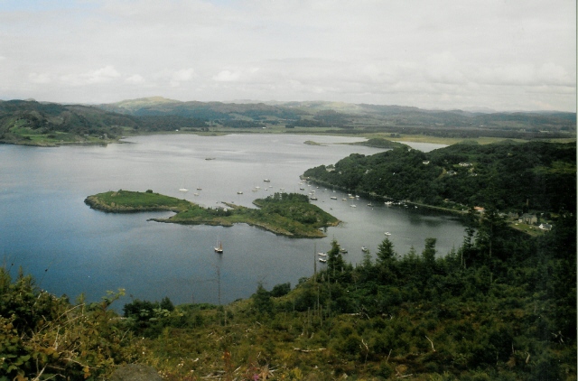
Loch Crinan

Loch Crinan is a seawater loch on the West of Scotland, leading into the Sound of Jura and being the western end of the Crinan Canal. The village of Crinan...

Ardifuir

Ardifuir is a village in Argyll and Bute, Scotland.

Duntrune Castle

Duntrune Castle is located on the north side of Loch Crinan and across from the village of Crinan in Argyll, Scotland. It is thought to be the oldest continuously...
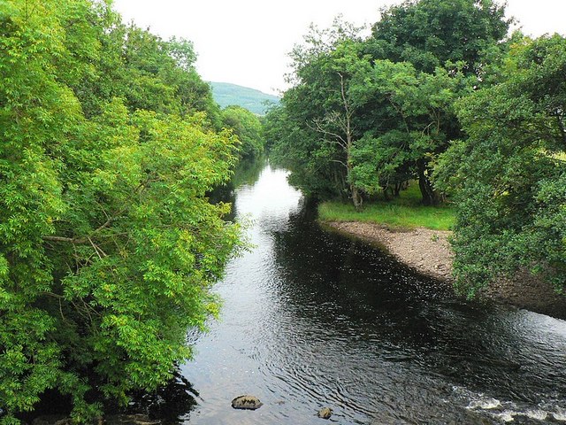
River Add

The River Add (Scottish Gaelic: Abhainn Àd) is a river which runs through Argyll and Bute on the West of Scotland. Historically, it was known as the river...
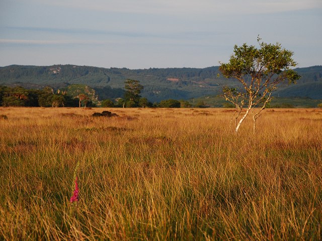
Moine Mhòr

Moine Mhòr ("Great Moss" in Scottish Gaelic) encompasses a large area of raised bog in the Kilmartin Glen area of Argyll and Bute, Scotland. As well as...

Argyll and Bute

Argyll and Bute (Scots: Argyll an Buit; Scottish Gaelic: Earra-Ghàidheal agus Bòd, pronounced [ɛrˠəˈɣɛːəlˠ̪ akəs̪ ˈpɔːtʲ]) is one of 32 unitary council...

Nearby Amenities

Located within 500m of 56.086281,-5.560194
Source: PGS
Lat/Long: 56.0891908/-5.5642083
Source: PGS
Lat/Long: 56.0884519/-5.5649795
Source: PGS
Lat/Long: 56.0883908/-5.56513
Source: PGS
Lat/Long: 56.0877154/-5.5665513
Source: PGS
Lat/Long: 56.0900974/-5.5630004
Source: PGS
Lat/Long: 56.0895361/-5.5638225
Source: Aerial Photography
Tourism: picnic_site
Lat/Long: 56.0852209/-5.5663542
Ele: 96
Natural: peak
Lat/Long: 56.0862149/-5.552862
Ele: 54
Natural: peak
Lat/Long: 56.0883207/-5.5595139
Power: pole
Lat/Long: 56.084928/-5.559842
Power: pole
Lat/Long: 56.0844647/-5.5586276
Power: pole
Lat/Long: 56.0867699/-5.5631402
Power: pole
Lat/Long: 56.0864017/-5.5621907
Power: pole
Lat/Long: 56.08608/-5.5612975
Power: pole
Lat/Long: 56.085709/-5.5603217
Power: pole
Lat/Long: 56.0840736/-5.5576066
Power: pole
Lat/Long: 56.0833457/-5.5557212
Power: pole
Lat/Long: 56.0836031/-5.5537149
Power: pole
Lat/Long: 56.0880883/-5.5588574
Power: pole
Lat/Long: 56.0887747/-5.5589099
Bus Stop
Crinan, Minor Road, At Cottages
Bench: no
Bus: yes
Naptan AtcoCode: 60709437
Naptan NaptanCode: 54724839
Public Transport: platform
Shelter: no
Lat/Long: 56.0889467/-5.5605518
Power: pole
Lat/Long: 56.0873548/-5.5614705
Power: pole
Lat/Long: 56.0878575/-5.5596389
Power: pole
Lat/Long: 56.0900094/-5.5587548
Power: pole
Lat/Long: 56.0906178/-5.5606867
Power: pole
Lat/Long: 56.0870886/-5.5639583
Direction: 95
Information: map
Map Type: yes
Tourism: information
Lat/Long: 56.0902148/-5.5569544
Vending Machine
Check Date: 2023-06-29
Currency GBP: yes
Direction: 95
Payment Coins: yes
Vending: parking_tickets
Lat/Long: 56.0901843/-5.5569545
Crinan Telephone Exchange
Addr City: Lochgilphead
Addr Postcode: PA31 8SW
Addr Village: Crinan
Ref: WSCRN
Lat/Long: 56.0849987/-5.5589667
Man Made: chimney
Lat/Long: 56.0879222/-5.5645457
The data included in this document is from www.openstreetmap.org. The data is made available under ODbL.

Have you been to An Crìonan?

Leave your review of An Crìonan below (or comments, questions and feedback).