Àird Mhòr

Settlement in Inverness-shire

Scotland

Àird Mhòr

Moored at Àird Mhòr The 'SY' boat registration is for Stornoway.
Moored at Àird Mhòr Credit: John Lucas

Àird Mhòr is a small village located in the Inverness-shire region of Scotland. Situated on the western coast, it is surrounded by breathtaking natural beauty and offers a tranquil escape from the bustling city life.

The village is characterized by its picturesque landscape, with rolling hills, lush greenery, and stunning views of the nearby Loch Torridon. It is a popular destination for outdoor enthusiasts, offering various activities such as hiking, mountain biking, and fishing. The nearby Beinn Eighe Nature Reserve is a must-visit for nature lovers, with its diverse wildlife and well-maintained trails.

Àird Mhòr has a rich history dating back centuries, evident in its traditional architecture and historic landmarks. The village is home to a charming church, which has stood for generations and holds regular services. The local community takes pride in preserving their heritage, and visitors can often find traditional Scottish music and dancing events taking place in the village hall.

Despite its small size, Àird Mhòr boasts a close-knit community that warmly welcomes visitors. The village has a few local amenities, including a small grocery store and a cozy pub, where visitors can enjoy a pint of locally brewed beer and engage in friendly conversations with the locals.

For those seeking a peaceful retreat in the heart of the Scottish Highlands, Àird Mhòr offers a perfect blend of natural beauty, outdoor activities, and traditional Scottish culture. It is a hidden gem that promises an unforgettable experience for all who visit.

If you have any feedback on the listing, please let us know in the comments section below.

Àird Mhòr Images

Images are sourced within 2km of 57.013228/-7.4304703 or Grid Reference NF7004. Thanks to Geograph Open Source API. All images are credited.

Moored at Àird Mhòr The 'SY' boat registration is for Stornoway.
Moored at Àird Mhòr
The 'SY' boat registration is for Stornoway.
Rocky foreshore at Àird Mhòr
The Barra to Eriskay ferry Standing just offshore between services.
The Barra to Eriskay ferry
Standing just offshore between services.
Departing from Barra On the Àird Mhòr to Eriskay ferry
Departing from Barra
On the Àird Mhòr to Eriskay ferry
Approaching Ardmhor View from the Eriskay ferry towards the harbour and ramp as the ferry approaches Ardmhor on Barra.
Approaching Ardmhor
View from the Eriskay ferry towards the harbour and ramp as the ferry approaches Ardmhor on Barra.
Whitehouse at Aird Mhidhinis The 'whitehouse' replaced the old drystone built and thatched 'blackhouse' in the Highlands and Islands.
Whitehouse at Aird Mhidhinis
The 'whitehouse' replaced the old drystone built and thatched 'blackhouse' in the Highlands and Islands.
Northbay road junction
Rivet on rock near Tràigh Mhòr, Barra Ordnance Survey benchmark on living rock near Barra's airport, described on database at <span class="nowrap"><a title="http://www.bench-marks.org.uk/bm76311" rel="nofollow ugc noopener" href="http://www.bench-marks.org.uk/bm76311">Link</a><img style="margin-left:2px;" alt="External link" title="External link - shift click to open in new window" src="https://s1.geograph.org.uk/img/external.png" width="10" height="10"/></span>.  Most of the benchmarks on the island are rivet types and have been placed in roadside living rocks. Not all of them are still extant. See also <a href="https://www.geograph.org.uk/photo/4996180">NF7004 : Rock showing rivet benchmark near Tràigh Mhòr, Barra</a>.
Rivet on rock near Tràigh Mhòr, Barra
Ordnance Survey benchmark on living rock near Barra's airport, described on database at LinkExternal link. Most of the benchmarks on the island are rivet types and have been placed in roadside living rocks. Not all of them are still extant. See also NF7004 : Rock showing rivet benchmark near Tràigh Mhòr, Barra.
Rock showing rivet benchmark near Tràigh Mhòr, Barra Ordnance Survey benchmark near the beach which serves as Barra's airport. See also <a href="https://www.geograph.org.uk/photo/4996176">NF7004 : Rivet on rock near Tràigh Mhòr, Barra</a>.
Rock showing rivet benchmark near Tràigh Mhòr, Barra
Ordnance Survey benchmark near the beach which serves as Barra's airport. See also NF7004 : Rivet on rock near Tràigh Mhòr, Barra.
Cut benchmark on St Barr Church, Northbay, Barra Ordnance Survey benchmark, described on database at <span class="nowrap"><a title="http://www.bench-marks.org.uk/bm76309" rel="nofollow ugc noopener" href="http://www.bench-marks.org.uk/bm76309">Link</a><img style="margin-left:2px;" alt="External link" title="External link - shift click to open in new window" src="https://s1.geograph.org.uk/img/external.png" width="10" height="10"/></span>. The only cut mark on the island.
Cut benchmark on St Barr Church, Northbay, Barra
Ordnance Survey benchmark, described on database at LinkExternal link. The only cut mark on the island.
Rivet in concrete drain surround near  Aird Mhidhinis, Barra Ordnance Survey rivet benchmark in drain surround near Barra's airport. For full description, see <span class="nowrap"><a title="http://www.bench-marks.org.uk/bm76313" rel="nofollow ugc noopener" href="http://www.bench-marks.org.uk/bm76313">Link</a><img style="margin-left:2px;" alt="External link" title="External link - shift click to open in new window" src="https://s1.geograph.org.uk/img/external.png" width="10" height="10"/></span>.
Rivet in concrete drain surround near Aird Mhidhinis, Barra
Ordnance Survey rivet benchmark in drain surround near Barra's airport. For full description, see LinkExternal link.
Waiting for the ferry at Ardmhor, Barra
Drying ground at Bagh Thiarabhagh
Beached boat, Northbay This might even be where an old boat goes to die.
Beached boat, Northbay
This might even be where an old boat goes to die.
Drying harbour at Thiarabhagh (Northbay) Vessels showing 'CY' for their registration port, Castlebay (although there is a Campbeltown, CN, boat there as well).
Drying harbour at Thiarabhagh (Northbay)
Vessels showing 'CY' for their registration port, Castlebay (although there is a Campbeltown, CN, boat there as well).
Through the hollow to the water There are not many trees on Barra, but there are a few here.
Through the hollow to the water
There are not many trees on Barra, but there are a few here.
View of Barra airport runway on the beach The airport buildings visible in the far distance.  Runway warning post just visible in the middle distance.
View of Barra airport runway on the beach
The airport buildings visible in the far distance. Runway warning post just visible in the middle distance.
Bàgh Thiarabhagh
Bàgh Thiarabhagh
Show me another place!

Àird Mhòr is located at Grid Ref: NF7004 (Lat: 57.013228, Lng: -7.4304703)

Unitary Authority: Na h-Eileanan an Iar

Police Authority: Highlands and Islands

Also known as: Ardmhor

What 3 Words

///composts.section.mailboxes. Near CastleBay, Na h-Eileanan Siar

Related Wikis

Northbay

Northbay (Scottish Gaelic: Am Bàgh a Tuath) is a township and community in the north of Barra in the Outer Hebrides, off the west coast of Scotland. Northbay...

Ardveenish

Ardveenish (Scottish Gaelic: Àird Mhèanais) is a village on Barra in the Western Isles, Scotland. Ardveenish is also within the parish of Barra. ��2�...
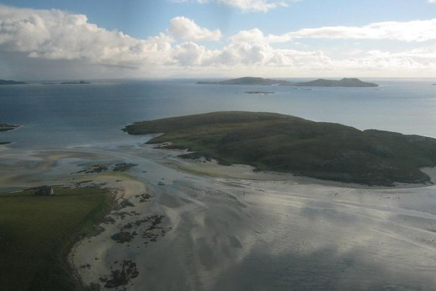
Traigh Mhòr

The Tràigh Mhòr, in English 'Big Beach', is a large expanse of sand forming a magnificent white beach at the northern end of the island of Barra in the...
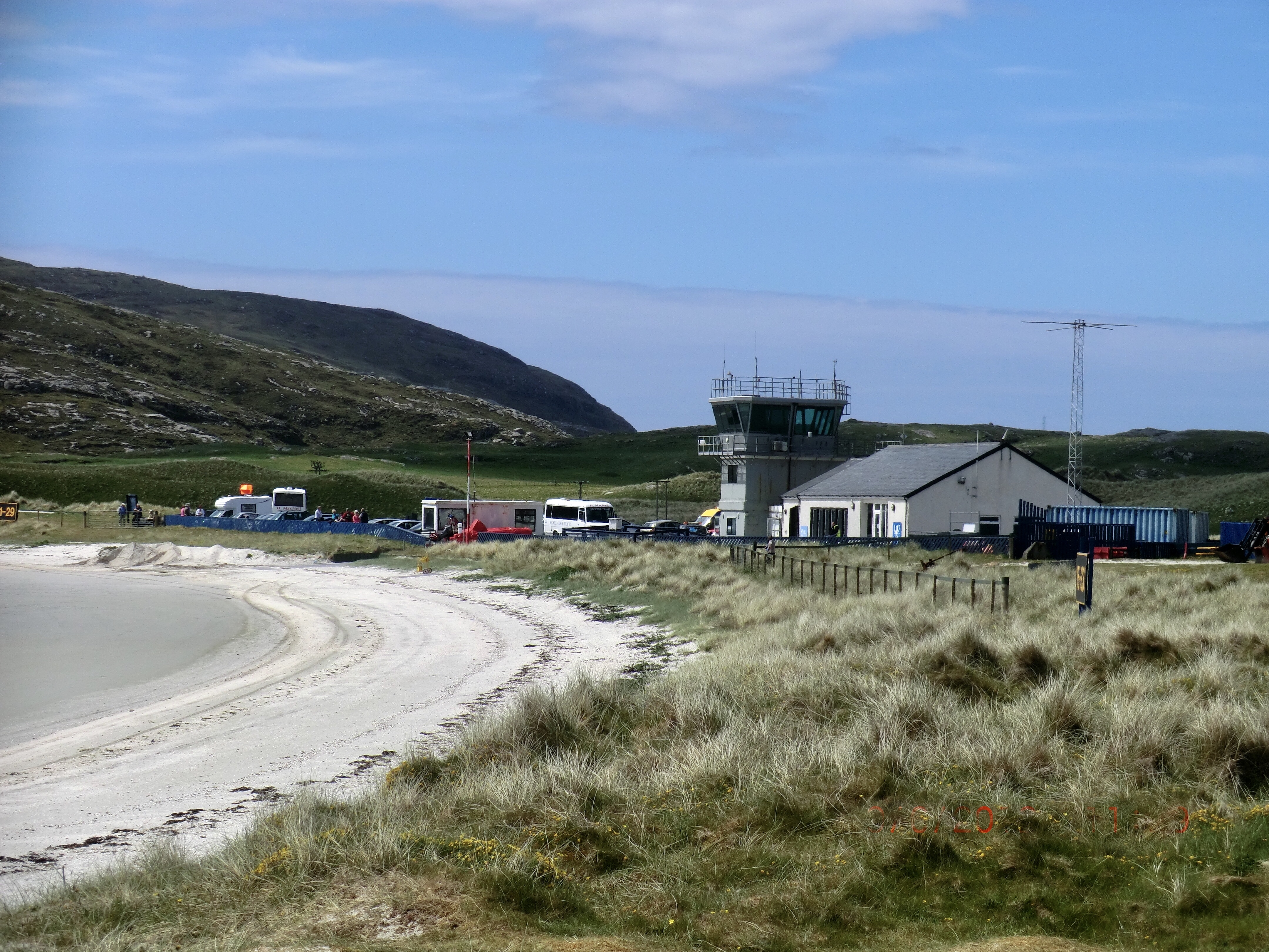
Barra Airport

Barra Airport (Scottish Gaelic: Port-adhair Bharraigh) (IATA: BRR, ICAO: EGPR) (also known as Barra Eoligarry Airport) is a short-runway airport (or STOLport...

Orosay

Orosay (Scottish Gaelic: Orasaigh) is a small uninhabited tidal island in the Sound of Barra lying at the north end of Traigh Mhòr, the "big beach" on...
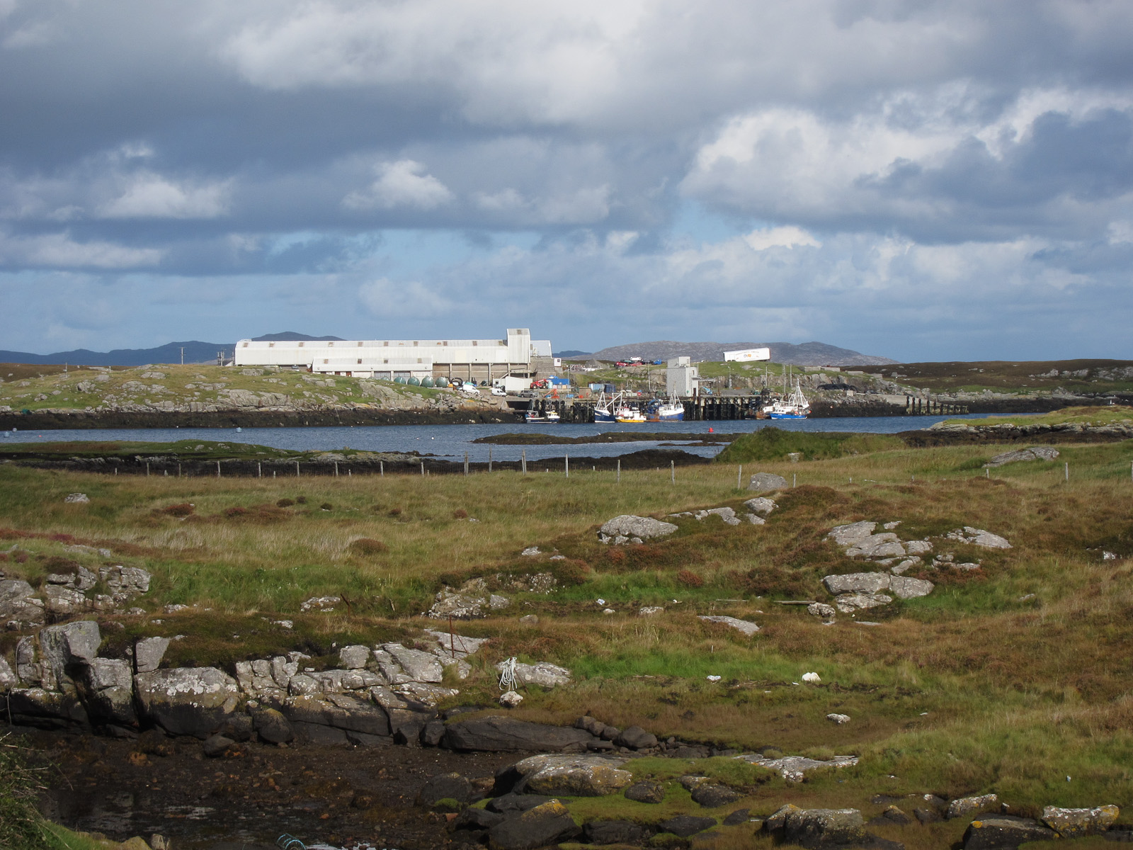
Ardmore, Barra

Ardmhor (Scottish Gaelic: Aird Mhòr) is a small village in the north east of the Isle of Barra in the Outer Hebrides, Scotland. In 2002 a small ferry port...

Bogach

Bogach (Scottish Gaelic: A' Bhogach) is a village on the island of Barra in the Outer Hebrides, Scotland. Bogach is also within the parish of Barra, and...

Barra

Barra (; Scottish Gaelic: Barraigh [ˈparˠaj] or Eilean Bharraigh [ˈelan ˈvarˠaj] ; Scots: Barra) is an island in the Outer Hebrides, Scotland, and the...

Nearby Amenities

Located within 500m of 57.013228,-7.4304703
Passing Place
Source: Bing
Lat/Long: 57.011089/-7.4252767
Telephone
Booth: K6
Covered: booth
Operator: BT
Phone: +44 1871 890207
Source: survey
Lat/Long: 57.0133669/-7.4303748
Passing Place
Source: Bing
Lat/Long: 57.0122162/-7.4276529
Passing Place
Source: Bing
Lat/Long: 57.016745/-7.4356158
Passing Place
Source: Bing
Lat/Long: 57.0120109/-7.4320399
Passing Place
Source: Bing
Lat/Long: 57.0089435/-7.4289223
Passing Place
Source: Bing
Lat/Long: 57.0097145/-7.4297053
Passing Place
Source: Bing
Lat/Long: 57.0137158/-7.430712
Passing Place
Source: Bing
Lat/Long: 57.0108655/-7.4316716
Passing Place
Source: Bing
Lat/Long: 57.0116733/-7.4332238
Post Box
Note: RM list suggests different number
Operator: Royal Mail
Post Box Type: lamp
Ref: HS9 9
Royal Cypher: scottish_crown
Lat/Long: 57.0133445/-7.4303662
Power: pole
Lat/Long: 57.012661/-7.4305451
Power: pole
Lat/Long: 57.0122507/-7.4303305
Power: pole
Lat/Long: 57.0116979/-7.430065
Power: pole
Lat/Long: 57.0112767/-7.4298545
Power: pole
Lat/Long: 57.0104661/-7.4294615
Power: pole
Lat/Long: 57.0159284/-7.4360061
Power: pole
Lat/Long: 57.0153414/-7.4350257
Power: pole
Lat/Long: 57.01485/-7.4341755
Power: pole
Lat/Long: 57.0143389/-7.4333131
Power: pole
Lat/Long: 57.0137731/-7.4323542
Power: pole
Lat/Long: 57.0132167/-7.4314034
Power: pole
Lat/Long: 57.0133744/-7.4309233
Power: pole
Lat/Long: 57.0135745/-7.4303091
Power: pole
Lat/Long: 57.0137585/-7.4297901
Power: pole
Lat/Long: 57.0135015/-7.429326
Power: pole
Lat/Long: 57.0132218/-7.4288057
Power: pole
Lat/Long: 57.0129422/-7.4282666
Power: pole
Lat/Long: 57.0124369/-7.4273278
Power: pole
Lat/Long: 57.0119236/-7.4263555
Power: pole
Lat/Long: 57.0115001/-7.4251659
Power: pole
Lat/Long: 57.0108495/-7.4243733
Power: pole
Lat/Long: 57.0100601/-7.429263
Power: pole
Lat/Long: 57.0093218/-7.4298839
Power: pole
Lat/Long: 57.0089129/-7.430006
Power: pole
Lat/Long: 57.0090224/-7.431115
Power: pole
Lat/Long: 57.0093817/-7.4315992
Power: pole
Lat/Long: 57.0100046/-7.431964
Power: pole
Lat/Long: 57.011024/-7.4325836
Power: pole
Lat/Long: 57.0117702/-7.4324803
Power: pole
Lat/Long: 57.0122317/-7.4324361
Power: pole
Lat/Long: 57.012661/-7.4334955
Power: pole
Lat/Long: 57.0129371/-7.4341527
Power: pole
Lat/Long: 57.0135591/-7.4347991
Power: pole
Lat/Long: 57.0141418/-7.4354669
Power: pole
Lat/Long: 57.0146894/-7.4360463
Power: pole
Lat/Long: 57.0150895/-7.4365747
Power: pole
Lat/Long: 57.0154976/-7.4371246
Power: pole
Lat/Long: 57.0156736/-7.4307315
Power: pole
Lat/Long: 57.0152918/-7.4305478
Power: pole
Lat/Long: 57.0149442/-7.4303775
Power: pole
Lat/Long: 57.0145996/-7.4302018
Power: pole
Lat/Long: 57.0141184/-7.4299818
Barrier: cattle_grid
Lat/Long: 57.0149767/-7.4312078
Barrier: cattle_grid
Lat/Long: 57.0145338/-7.4303449
Passing Place
Lat/Long: 57.01494/-7.4322704
Passing Place
Lat/Long: 57.0118045/-7.4267936
Power: pole
Lat/Long: 57.0106326/-7.4302045
Bus Stop
Road End
Bus: yes
Public Transport: platform
Lat/Long: 57.013083/-7.4302823
Bus Stop
Road End
Bus: yes
Public Transport: platform
Lat/Long: 57.013067/-7.430484
Bus Stop
Road End
Bus: yes
Public Transport: platform
Lat/Long: 57.013237/-7.4303718
The data included in this document is from www.openstreetmap.org. The data is made available under ODbL.

Have you been to Àird Mhòr?

Leave your review of Àird Mhòr below (or comments, questions and feedback).