Mercombe Wood

Wood, Forest in Wiltshire

England

Mercombe Wood

Old Milestone by A420, Giddeahall, opposite Car Park; top of bank The Milestone is located by the road on the North of the road.  Parish of Yatton Keynell (North Wiltshire District). Metal plate attached to stone post, Marshfield iron plate design, erected by the Chippenham turnpike trust in the 19th Century. An earlier photograph can be found here: <a title="https://www.geograph.org.uk/photo/6102709" href="https://www.geograph.org.uk/photo/6102709">Link</a> 

Inscription reads:-  
5 MILES / TO / MARSHFIELD / 4 MILES / TO / CHIPPENHAM 

Milestone Society National ID: WI_CPMF04
Old Milestone by A420, Giddeahall, opposite Car Park; top of bank Credit: Roadside Relics

Mercombe Wood is a picturesque woodland located in Wiltshire, England. Covering an area of approximately 150 acres, it is a popular destination for nature lovers and outdoor enthusiasts. The wood is situated near the village of Collingbourne Kingston, surrounded by rolling hills and countryside.

The wood is predominantly composed of broadleaf trees, including oak, ash, and beech, creating a diverse and vibrant ecosystem. The dense canopy provides a haven for a wide range of bird species, such as woodpeckers, tits, and finches, making it a haven for birdwatchers.

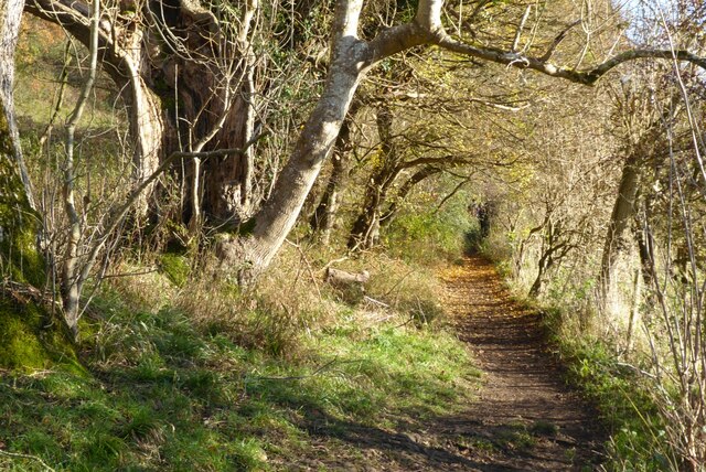
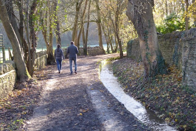
A network of well-maintained footpaths winds through Mercombe Wood, offering visitors the opportunity to explore the area at their own pace. The paths meander through sun-dappled glades, dense thickets, and alongside babbling brooks, providing a peaceful and tranquil escape from the hustle and bustle of everyday life.

The wood is also home to an abundance of wildlife, including deer, foxes, badgers, and various species of reptiles and amphibians. Keen-eyed visitors may even spot the elusive red squirrel, a rare and protected species in the UK.

Mercombe Wood is managed by a local conservation organization, which ensures the protection and preservation of its natural beauty. The wood is open to the public year-round, with no entry fee, allowing people to enjoy its charms in all seasons.

Overall, Mercombe Wood is a hidden gem in Wiltshire, offering a serene and enchanting experience for nature enthusiasts, walkers, and wildlife lovers alike.

If you have any feedback on the listing, please let us know in the comments section below.

Mercombe Wood Images

Images are sourced within 2km of 51.470735/-2.2245436 or Grid Reference ST8474. Thanks to Geograph Open Source API. All images are credited.

Old Milestone by A420, Giddeahall, opposite Car Park; top of bank The Milestone is located by the road on the North of the road.  Parish of Yatton Keynell (North Wiltshire District). Metal plate attached to stone post, Marshfield iron plate design, erected by the Chippenham turnpike trust in the 19th Century. An earlier photograph can be found here: <a title="https://www.geograph.org.uk/photo/6102709" href="https://www.geograph.org.uk/photo/6102709">Link</a> 

Inscription reads:-  
5 MILES / TO / MARSHFIELD / 4 MILES / TO / CHIPPENHAM 

Milestone Society National ID: WI_CPMF04
Old Milestone by A420, Giddeahall, opposite Car Park; top of bank
The Milestone is located by the road on the North of the road.  Parish of Yatton Keynell (North Wiltshire District). Metal plate attached to stone post, Marshfield iron plate design, erected by the Chippenham turnpike trust in the 19th Century. An earlier photograph can be found here: Link  Inscription reads:- 5 MILES / TO / MARSHFIELD / 4 MILES / TO / CHIPPENHAM Milestone Society National ID: WI_CPMF04
Macmillan Way near Castle Combe By Brook follows through this valley.
Macmillan Way near Castle Combe
By Brook follows through this valley.
The Macmillan Way The Macmillan Way between Castle Combe and Long Dean.
The Macmillan Way
The Macmillan Way between Castle Combe and Long Dean.
Autumn beech trees Autumn beech trees beside the Macmillan Way between Castle Combe and Long Dean.
Autumn beech trees
Autumn beech trees beside the Macmillan Way between Castle Combe and Long Dean.
The Macmillan Way The Macmillan Way passing beech trees with a few autumn leaves remaining to the south of Castle Combe.
The Macmillan Way
The Macmillan Way passing beech trees with a few autumn leaves remaining to the south of Castle Combe.
The Macmillan Way south of Castle Combe The Macmillan Way south of Castle Combe above By Brook which flows through this combe.
The Macmillan Way south of Castle Combe
The Macmillan Way south of Castle Combe above By Brook which flows through this combe.
The Macmillan Way The Macmillan Way south of Castle Combe following the combe through which By Brook flows.
The Macmillan Way
The Macmillan Way south of Castle Combe following the combe through which By Brook flows.
The Macmillan Way near Long Dean
Cottages in Long Dean The Macmillan Way long distance path follows a bridleway as it passes through this small hamlet of Long Dean.
Cottages in Long Dean
The Macmillan Way long distance path follows a bridleway as it passes through this small hamlet of Long Dean.
The Macmillan Way entering Long Dean The Macmillan Way following a bridleway as it enters the hamlet of Long Dean.
The Macmillan Way entering Long Dean
The Macmillan Way following a bridleway as it enters the hamlet of Long Dean.
Former mill in Long Dean The Macmillan Way passing a former Mill in Long Dean.
Former mill in Long Dean
The Macmillan Way passing a former Mill in Long Dean.
A couple walking on a bridleway This bridleway in Long Dean is the route of the long distance path, the Macmillan Way.  The water course on the right is possibly a former mill leat.
A couple walking on a bridleway
This bridleway in Long Dean is the route of the long distance path, the Macmillan Way. The water course on the right is possibly a former mill leat.
Cottages in Long Dean
Bridleway near Long Dean This bridleway follows a combe below West Yatton Down.
Bridleway near Long Dean
This bridleway follows a combe below West Yatton Down.
Road junction above Castle Combe
The Crown Inn Some of the structure of this historic coaching inn may date back into the 15th C but at that time its location didn't carry its unusual, current name of Giddea Hall; which is probably 18th C.
The Crown Inn
Some of the structure of this historic coaching inn may date back into the 15th C but at that time its location didn't carry its unusual, current name of Giddea Hall; which is probably 18th C.
Looking west along The Old Coach Road The byway has a good stone surface at this point.
Looking west along The Old Coach Road
The byway has a good stone surface at this point.
Looking east along The Old Coach Road
Show me another place!

Mercombe Wood is located at Grid Ref: ST8474 (Lat: 51.470735, Lng: -2.2245436)

Unitary Authority: Wiltshire

Police Authority: Wiltshire

What 3 Words

///method.everybody.trombone. Near Biddestone, Wiltshire

Related Wikis

Ford, North Wiltshire

Ford is a small village in the north-west of Wiltshire, England. The village is on the A420 road, 4 miles west of Chippenham and 11 miles east of Bristol...

Slaughterford

Slaughterford is a small village in the civil parish of Biddestone and Slaughterford, about 5 miles (8 km) west of Chippenham, in Wiltshire, England. The...

West Yatton Down

West Yatton Down (grid reference ST852760) is a 14.4 hectare biological Site of Special Scientific Interest in Wiltshire, notified in 1971. The site is...

Honeybrook Farm

Honeybrook Farm (grid reference ST841730) is a working farm three miles (4.8 km) south of Castle Combe in Wiltshire, England, between the villages of Biddestone...

Nearby Amenities

Located within 500m of 51.470735,-2.2245436
Ford
Is In: Wiltshire, England, UK
Place: hamlet
Postal Code: SN14 8
Wikidata: Q5467611
Lat/Long: 51.4725437/-2.2295642
Telephone
Booth: K6
Covered: booth
Listed Status: Grade II
Operator: BT
Operator Wikidata: Q593786
Phone: +44 1249 782469
Postal Code: SN14 8RP
Lat/Long: 51.4725793/-2.2300012
Bus Stop
Ford, Park Lane
Bus: yes
Naptan AtcoCode: 4600WIA11682
Naptan Bearing: E
Naptan CommonName: Park Lane
Naptan Indicator: E-bound
Naptan NaptanCode: wiladwmg
Naptan Street: Bristol Road
Naptan Verified: no
Public Transport: platform
Source: mapilary;naptan;bing;naptan_compare_tool
Lat/Long: 51.4725756/-2.2279218
Post Box
Collection Times: Mo-Fr 16:45; Sa 08:45
Drive Through: no
Operator: Royal Mail
Operator Wikidata: Q638098
Post Box Mounting: metal_post
Post Box Type: lamp
Ref: SN14 97
Royal Cypher: EIIR
Royal Cypher Wikidata: Q33102113
Source: survey
Lat/Long: 51.4725835/-2.2300705
Barrier: stile
Bicycle: private
Foot: designated
Horse: private
Motor Vehicle: private
Lat/Long: 51.4742573/-2.2244264
Barrier: kissing_gate
Lat/Long: 51.4727711/-2.2218669
Barrier: stile
Lat/Long: 51.4746516/-2.2213023
Disused Amenity: post_box
Post Box Type: wall
Royal Cypher: GVIR
Lat/Long: 51.4725454/-2.229129
Power: pole
Lat/Long: 51.4663205/-2.2246247
Power: pole
Lat/Long: 51.4663926/-2.2232686
The data included in this document is from www.openstreetmap.org. The data is made available under ODbL.

Have you been to Mercombe Wood?

Leave your review of Mercombe Wood below (or comments, questions and feedback).