Gib Lane Wood

Wood, Forest in Cheshire

England

Gib Lane Wood

Church of St Martin On Blackcarr Road and apparently not in use with services transferred to the church hall
Church of St Martin Credit: Kevin Waterhouse

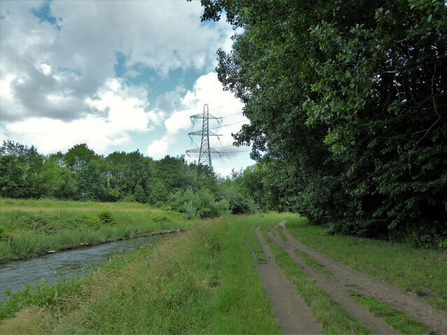
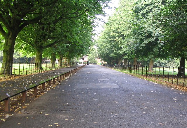
Gib Lane Wood is a picturesque woodland located in the county of Cheshire, England. It covers an area of approximately 50 acres and is situated near the small village of Gibbington. The woodland is part of a larger forested area and is surrounded by rolling hills and fields, providing a tranquil and scenic setting.

The wood is primarily composed of native broadleaf trees, such as oak, beech, and birch, which create a diverse and vibrant ecosystem. The dense canopy of foliage provides shade and shelter for a variety of wildlife, including birds, mammals, and insects. Birdwatchers can often spot species such as woodpeckers, nuthatches, and tawny owls, while the woodland floor is home to small mammals like squirrels and rabbits.

Gib Lane Wood is a popular destination for nature enthusiasts and hikers who enjoy exploring its network of well-maintained footpaths. These paths wind through the woodland, offering visitors the opportunity to immerse themselves in the peaceful surroundings and enjoy the sights and sounds of nature. Along the way, there are several designated picnic areas where visitors can take a break and enjoy a meal amidst the beauty of the wood.

The woodland is managed by a local conservation group, which ensures the preservation of its natural features and promotes sustainable practices. They periodically organize educational events and guided tours to raise awareness about the importance of preserving this valuable habitat.

Overall, Gib Lane Wood is a charming and enchanting woodland that offers visitors a chance to escape the hustle and bustle of daily life and connect with nature in a serene and idyllic setting.

If you have any feedback on the listing, please let us know in the comments section below.

Gib Lane Wood Images

Images are sourced within 2km of 53.402667/-2.2687083 or Grid Reference SJ8289. Thanks to Geograph Open Source API. All images are credited.

Church of St Martin On Blackcarr Road and apparently not in use with services transferred to the church hall
Church of St Martin
On Blackcarr Road and apparently not in use with services transferred to the church hall
Railway view towards Stockport From the bridge on Hall Lane across the Altrincham to Stockport line
Railway view towards Stockport
From the bridge on Hall Lane across the Altrincham to Stockport line
Fun bikes on running track The large fenced track in Wythenshawe Park
Fun bikes on running track
The large fenced track in Wythenshawe Park
Riverside track By the side of the River Mersey
Riverside track
By the side of the River Mersey
Former bus garage, Bradnor Road, Manchester By G. Noel Hill, City Architect, 1938-42. A very innovative building. "A huge clear span of 296 by 185ft covers spaces for 100 buses". The concrete exterior employed the Chisarc system. "On completion it was handed over to Messrs. A.V. Roe for building Lancaster bombers." Grade II* listed.
It now sits in the Sharston Industrial Area and appears to be used for something.
Former bus garage, Bradnor Road, Manchester
By G. Noel Hill, City Architect, 1938-42. A very innovative building. "A huge clear span of 296 by 185ft covers spaces for 100 buses". The concrete exterior employed the Chisarc system. "On completion it was handed over to Messrs. A.V. Roe for building Lancaster bombers." Grade II* listed. It now sits in the Sharston Industrial Area and appears to be used for something.
124 Longley Lane, Manchester The Sharston Industrial Area has several modest 1930s Deco factories.
Siltint provides "Thin Film Vacuum Coating processes  for the precision optical and opto-electronic industries."
124 Longley Lane, Manchester
The Sharston Industrial Area has several modest 1930s Deco factories. Siltint provides "Thin Film Vacuum Coating processes for the precision optical and opto-electronic industries."
Southmoor House, Southmoor Road, Manchester A 1930s block fronting Southmoor Industrial Estate. There is a further block to the right, Trafford House, and extensive sheds behind.
The tram runs in front.
Southmoor House, Southmoor Road, Manchester
A 1930s block fronting Southmoor Industrial Estate. There is a further block to the right, Trafford House, and extensive sheds behind. The tram runs in front.
Offices, Southmoor Road, Manchester Post-war, possibly counting as part of the Southmoor Industrial Estate.
Since pulled down and replaced by a Lidl supermarket.
Offices, Southmoor Road, Manchester
Post-war, possibly counting as part of the Southmoor Industrial Estate. Since pulled down and replaced by a Lidl supermarket.
Moorcot Court, Bideford Drive, Manchester A nine-storey slab containing 73 flats which was probably built in the late 1960s.
Moorcot Court, Bideford Drive, Manchester
A nine-storey slab containing 73 flats which was probably built in the late 1960s.
Brookway Court, Bideford Drive, Manchester A 17-storey point block containing 94 flats which was built c1967.
Brookway Court, Bideford Drive, Manchester
A 17-storey point block containing 94 flats which was built c1967.
Southmoor, Glebelands Road, Manchester A nine-storey slab containing 73 flats which was built c1960.
Southmoor, Glebelands Road, Manchester
A nine-storey slab containing 73 flats which was built c1960.
Metrolink tracks near Roundthorn Station The tracks are making a sharp bend to turn from the station in Southmoor Road (behind the camera) into Hollyhedge Road
Metrolink tracks near Roundthorn Station
The tracks are making a sharp bend to turn from the station in Southmoor Road (behind the camera) into Hollyhedge Road
Stream between culverts This stream appears on some open ground alongside Woodend Road, Benchill, otherwise it is within culverts.
Stream between culverts
This stream appears on some open ground alongside Woodend Road, Benchill, otherwise it is within culverts.
Tree lined Woodhouse Lane At Benchill, Wythenshawe
Tree lined Woodhouse Lane
At Benchill, Wythenshawe
Wythenshawe housing stock Lyndene Road, a typical road of housing in this suburb
Wythenshawe housing stock
Lyndene Road, a typical road of housing in this suburb
Church of St Luke the Physician On Brownley Road, Benchill
Church of St Luke the Physician
On Brownley Road, Benchill
Residential walkway Across Hollyhedge Road at Benchill
Residential walkway
Across Hollyhedge Road at Benchill
M56 joins the A560 in Wythenshawe Not sure what this building is, but I thought it looked great.
M56 joins the A560 in Wythenshawe
Not sure what this building is, but I thought it looked great.
Show me another place!

Gib Lane Wood is located at Grid Ref: SJ8289 (Lat: 53.402667, Lng: -2.2687083)

Unitary Authority: Manchester

Police Authority: Greater Manchester

What 3 Words

///entertainer.retain.brains. Near Didsbury, Manchester

Related Wikis

Wythenshawe Park

Wythenshawe Park is located in Northern moor & borders into Baguley England, covers an area of 270 acres. Wythenshawe Hall lies at its centre. The park...

Manchester Wythenshawe (UK Parliament constituency)

Manchester Wythenshawe was a parliamentary constituency centred on the Wythenshawe suburb of Manchester. It returned one Member of Parliament (MP) to...

Baguley

Baguley ( BAG-əl-ee) is an electoral ward of the city of Manchester in Wythenshawe, England. The population at the 2011 census was 14,794.The name Baguley...

Wythenshawe Hall

Wythenshawe Hall is a 16th-century timber-framed historic house and former manor house in Wythenshawe, Manchester, England, five miles (8 km) south of...

Wythenshawe and Sale East (UK Parliament constituency)

Wythenshawe and Sale East is a parliamentary constituency in the city of Manchester and the borough of Trafford. It returns one Member of Parliament...

Northern Moor

Northern Moor is an area of Manchester, England, north of Baguley, west of Northenden and east of Sale, 5 miles south of Manchester city centre. The Tatton...

Wythenshawe Bus Garage

Wythenshawe Bus Garage is a Grade II* listed building in Wythenshawe, Greater Manchester, England.Designed by Manchester City Architects Department under...

Wythenshawe community farm

Wythenshawe Community Farm is an educational farm based in Wythenshawe Park, South Manchester. Although set in an urban environment, it operates as a working...

Nearby Amenities

Located within 500m of 53.402667,-2.2687083
Crossing
Bicycle: yes
Crossing: traffic_signals
Crossing Ref: toucan
Kerb: lowered
Tactile Paving: yes
Lat/Long: 53.3988433/-2.2664425
Motorway Junction
Ref: 3A
Lat/Long: 53.4020939/-2.2680541
Motorway Junction
Lat/Long: 53.404232/-2.2677019
Bicycle: yes
Traffic Sign: GB:2931
Traffic Sign Direction: forward
Lat/Long: 53.4007755/-2.2689174
Crossing
Bicycle: yes
Crossing: traffic_signals
Crossing Ref: toucan
Kerb: lowered
Tactile Paving: yes
Lat/Long: 53.3989151/-2.2664062
Traffic Signals
Traffic Signals: signal
Lat/Long: 53.4068099/-2.2678247
Traffic Signals
Traffic Signals: signal
Lat/Long: 53.406892/-2.2681757
Traffic Signals
Lat/Long: 53.4069678/-2.2696376
Turning Circle
Lat/Long: 53.4060556/-2.2663894
Turning Circle
Lat/Long: 53.4023872/-2.2626236
Turning Circle
Lat/Long: 53.4019229/-2.2625421
Turning Circle
Lat/Long: 53.4025851/-2.2660919
Turning Circle
Lat/Long: 53.4002009/-2.2629193
Turning Circle
Lat/Long: 53.399302/-2.2640448
Bus Stop
Sharston, Altrincham Road / The Open University (Stop D)
Bus: yes
Local Ref: D
Naptan AtcoCode: 1800SB12801
Naptan Bearing: W
Naptan CommonName: Altrincham Rd/The Open University (D)
Naptan Indicator: Stop D
Naptan Landmark: ADULT T'RNG Centre
Naptan NaptanCode: mangpwgw
Naptan PlusbusZoneRef: MNCRPIC
Naptan ShortCommonName: Open University
Naptan Street: ALTRINCHAM ROAD
Naptan Verified: no
Network: TfGM
Operator: TfGM
Public Transport: platform
Ref: D
Source: naptan_import
Lat/Long: 53.3986394/-2.2656615
Bus Stop
Sharston, Altrincham Road / The Open University (Stop C)
Bus: yes
Local Ref: C
Naptan AtcoCode: 1800SB12831
Naptan Bearing: E
Naptan CommonName: Altrincham Rd/The Open University (C)
Naptan Indicator: Stop C
Naptan Landmark: CHURCH
Naptan NaptanCode: mangpwja
Naptan PlusbusZoneRef: MNCRPIC
Naptan ShortCommonName: Open University
Naptan Street: ALTRINCHAM ROAD
Naptan Verified: no
Network: TfGM
Operator: TfGM
Public Transport: platform
Ref: C
Source: naptan_import
Lat/Long: 53.3991132/-2.2668225
Bus Stop
Northenden, Wythenshawe Road / Princess Parkway (Stop C)
Bus: yes
Local Ref: C
Naptan AtcoCode: 1800SB41441
Naptan Bearing: W
Naptan CommonName: Wythenshawe Rd/Princess Parkway (Stop C)
Naptan Indicator: Stop C
Naptan Landmark: LAYBY
Naptan NaptanCode: mangwjtp
Naptan PlusbusZoneRef: MNCRPIC
Naptan ShortCommonName: Princess Parkway
Naptan Street: Wythenshawe Road
Naptan Verified: no
Network: TfGM
Operator: TfGM
Public Transport: platform
Source: naptan_import
Lat/Long: 53.4067938/-2.2689916
Bus Stop
Northenden, Princess Parkway / Britannia Hotel (Stop D)
Bench: yes
Bus: yes
Local Ref: D
Naptan AtcoCode: 1800SB42061
Naptan Bearing: S
Naptan CommonName: Britannia Hotel (Stop D)
Naptan Indicator: Stop D
Naptan Landmark: HOTEL
Naptan NaptanCode: mangwmpg
Naptan PlusbusZoneRef: MNCRPIC
Naptan ShortCommonName: Britannia Hotel
Naptan Street: PRINCESS PARKWY
Naptan Verified: no
Network: TfGM
Operator: TfGM
Public Transport: platform
Ref: D
Shelter: yes
Source: naptan_import
Lat/Long: 53.4063128/-2.267018
Bus Stop
Northenden, Palatine Road / Britannia Hotel (Stop E)
Bus: yes
Local Ref: E
Naptan AtcoCode: 1800SB14511
Naptan Bearing: E
Naptan CommonName: Britannia Hotel (Stop E)
Naptan Indicator: Stop E
Naptan Landmark: HOTEL
Naptan NaptanCode: mangtata
Naptan PlusbusZoneRef: MNCRPIC
Naptan ShortCommonName: Britannia Hotel
Naptan Street: PALATINE ROAD
Naptan Verified: no
Network: TfGM
Operator: TfGM
Public Transport: platform
Shelter: yes
Source: naptan_import
Lat/Long: 53.4067771/-2.2657138
Bus Stop
Sharston, Altrincham Road / Princess Parkway (Stop B)
Bus: yes
Local Ref: B
Naptan AtcoCode: 1800SB42991
Naptan Bearing: W
Naptan CommonName: Altrincham Rd/Princess Parkway (Stop B)
Naptan Indicator: Stop B
Naptan Landmark: NR WOOD
Naptan NaptanCode: mangwpdm
Naptan PlusbusZoneRef: MNCRPIC
Naptan ShortCommonName: Princess Parkway
Naptan Street: ALTRINCHAM ROAD
Naptan Verified: no
Network: TfGM
Operator: TfGM
Public Transport: platform
Ref: B
Source: naptan_import
Lat/Long: 53.3993295/-2.2705839
Bus Stop
Sharston, Altrincham Road / Princess Parkway (Stop A)
Bus: yes
Local Ref: A
Naptan AtcoCode: 1800SB43001
Naptan Bearing: E
Naptan CommonName: Altrincham Rd/Princess Parkway (Stop A)
Naptan Indicator: Stop A
Naptan Landmark: PARK LAND
Naptan NaptanCode: mangwpdp
Naptan PlusbusZoneRef: MNCRPIC
Naptan ShortCommonName: Princess Parkway
Naptan Street: ALTRINCHAM ROAD
Naptan Verified: no
Network: TfGM
Operator: TfGM
Public Transport: platform
Ref: A
Source: naptan_import
Lat/Long: 53.3997978/-2.2709564
Noexit: yes
Lat/Long: 53.400456/-2.2721576
Crossing
Crossing: unmarked
Crossing Island: no
Tactile Paving: no
Lat/Long: 53.4000994/-2.2709952
Turning Circle
Lat/Long: 53.4002176/-2.2701053
Turning Circle
Lat/Long: 53.4005546/-2.2714906
Turning Circle
Lat/Long: 53.4008978/-2.2642507
Traffic Calming: cushion
Lat/Long: 53.3989963/-2.2722799
Traffic Calming: cushion
Lat/Long: 53.3998363/-2.2743852
Crossing
Crossing: unmarked
Crossing Island: no
Kerb: lowered
Tactile Paving: no
Lat/Long: 53.4000735/-2.2717869
Crossing
Crossing: unmarked
Kerb: lowered
Tactile Paving: no
Lat/Long: 53.4005098/-2.2731965
Crossing
Crossing: unmarked
Kerb: lowered
Tactile Paving: no
Lat/Long: 53.3987532/-2.2694542
Give Way
Direction: forward
Lat/Long: 53.3987665/-2.2693826
Crossing
Crossing: unmarked
Crossing Island: yes
Tactile Paving: yes
Lat/Long: 53.3988462/-2.266746
Crossing
Crossing: unmarked
Kerb: lowered
Tactile Paving: yes
Lat/Long: 53.3988686/-2.2682745
Crossing
Crossing: unmarked
Crossing Island: yes
Tactile Paving: yes
Lat/Long: 53.3988898/-2.2669487
Traffic Signals
Traffic Signals: signal
Lat/Long: 53.4067481/-2.2668928
Pharmacy
Well Pharmacy
Brand: Well Pharmacy
Brand Wikidata: Q7726524
Brand Wikipedia: en:Well Pharmacy
Dispensing: yes
Healthcare: pharmacy
Opening Hours: Mo-Fr 08:15-18:15
Website: https://finder.well.co.uk/store/northenden-491-palatine-road
Lat/Long: 53.4064635/-2.2650644
Entrance: yes
Lat/Long: 53.4064547/-2.2646435
Traffic Signals
Traffic Signals: pedestrian_crossing
Lat/Long: 53.4068951/-2.2669971
Traffic Signals
Traffic Signals: signal
Lat/Long: 53.4066869/-2.26688
Traffic Signals
Traffic Signals: signal
Lat/Long: 53.4069003/-2.2669142
Crossing
Crossing: unmarked
Crossing Island: yes
Tactile Paving: yes
Lat/Long: 53.3988234/-2.2666293
Give Way
Direction: forward
Lat/Long: 53.3989043/-2.2670078
Give Way
Direction: backward
Lat/Long: 53.3988098/-2.2665634
Give Way
Direction: forward
Lat/Long: 53.3988644/-2.266829
Give Way
Direction: backward
Lat/Long: 53.3988771/-2.2668889
Give Way
Direction: forward
Lat/Long: 53.3987957/-2.2664874
Give Way
Direction: backward
Lat/Long: 53.398896/-2.2681868
Give Way
Direction: backward
Lat/Long: 53.3988422/-2.2683641
Give Way
Direction: backward
Lat/Long: 53.3987626/-2.2695493
Give Way
Direction: backward
Lat/Long: 53.4001222/-2.2717393
Give Way
Direction: forward
Lat/Long: 53.400022/-2.2718401
Bicycle: no
Foot: no
Horse: no
Maxspeed: 70 mph
Moped: no
Motor Vehicle: designated
Ref: M56
Traffic Sign: GB:2901
Traffic Sign Direction: forward
Lat/Long: 53.4009468/-2.2685924
Traffic Signals
Traffic Signals: crossing
Lat/Long: 53.3989228/-2.2664434
Traffic Signals
Traffic Signals: crossing
Lat/Long: 53.3988324/-2.2663815
Give Way
Lat/Long: 53.4066286/-2.2669901
Traffic Signals
Traffic Signals: signal
Lat/Long: 53.406724/-2.26813
Traffic Signals
Traffic Signals: signal
Lat/Long: 53.4067323/-2.2680729
Traffic Signals
Traffic Signals: signal
Lat/Long: 53.4069494/-2.2681978
Give Way
Lat/Long: 53.4070204/-2.2680601
Traffic Signals
Traffic Signals: signal
Lat/Long: 53.4068279/-2.2672253
The data included in this document is from www.openstreetmap.org. The data is made available under ODbL.

Have you been to Gib Lane Wood?

Leave your review of Gib Lane Wood below (or comments, questions and feedback).