Briery Bank Wood
Wood, Forest in Yorkshire Ribble Valley
England
Briery Bank Wood
Briery Bank Wood is a picturesque woodland located in the county of Yorkshire, England. Situated in the heart of the Yorkshire Dales, this forested area covers a vast expanse of approximately 500 acres. The wood is known for its diverse range of flora and fauna, making it a haven for nature enthusiasts and a popular destination for outdoor activities.
The woodland is characterized by its dense canopy of trees, predominantly consisting of oak, beech, and birch. These towering trees provide a cool and shaded environment, creating a tranquil and peaceful atmosphere within the wood. The forest floor is adorned with a carpet of wildflowers, adding splashes of color to the natural landscape.
Briery Bank Wood is home to a wide variety of wildlife, including deer, foxes, badgers, and numerous bird species. Ornithologists flock to the wood to catch a glimpse of the rare and elusive species that inhabit its trees and undergrowth. The wood also boasts a diverse insect population, including butterflies and beetles, attracting entomologists from far and wide.
The wood offers a network of well-maintained walking trails, allowing visitors to explore its beauty at their own pace. These trails wind through the forest, providing breathtaking views of the surrounding countryside and offering opportunities for birdwatching and photography. Briery Bank Wood also features picnic areas and benches, allowing visitors to relax and immerse themselves in the tranquility of nature.
Overall, Briery Bank Wood is a captivating woodland in Yorkshire, offering a rich natural environment and a haven for all who appreciate the beauty of the great outdoors.
If you have any feedback on the listing, please let us know in the comments section below.
Briery Bank Wood Images
Images are sourced within 2km of 53.926361/-2.3276168 or Grid Reference SD7847. Thanks to Geograph Open Source API. All images are credited.
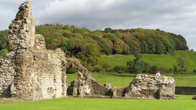
![Sawley village and abbey [1] An information board about the abbey.
Sawley is a small village on the banks of the River Ribble, some 3½ miles northeast of Clitheroe. The village is dominated by the ruins of the Cistercian abbey founded in 1148. The abbey was dissolved in 1536 and mostly demolished, the stone taken and reused in neighbouring farms and cottages. The ruins are now in the care of English Heritage. The abbey remains are listed, grade I, with details at: <span class="nowrap"><a title="https://historicengland.org.uk/listing/the-list/list-entry/1072099" rel="nofollow ugc noopener" href="https://historicengland.org.uk/listing/the-list/list-entry/1072099">Link</a><img style="margin-left:2px;" alt="External link" title="External link - shift click to open in new window" src="https://s1.geograph.org.uk/img/external.png" width="10" height="10"/></span> The site is a Scheduled Ancient Monument with much detail at: <span class="nowrap"><a title="https://historicengland.org.uk/listing/the-list/list-entry/1015492" rel="nofollow ugc noopener" href="https://historicengland.org.uk/listing/the-list/list-entry/1015492">Link</a><img style="margin-left:2px;" alt="External link" title="External link - shift click to open in new window" src="https://s1.geograph.org.uk/img/external.png" width="10" height="10"/></span>](https://s0.geograph.org.uk/geophotos/07/02/65/7026512_73de4ce8.jpg)
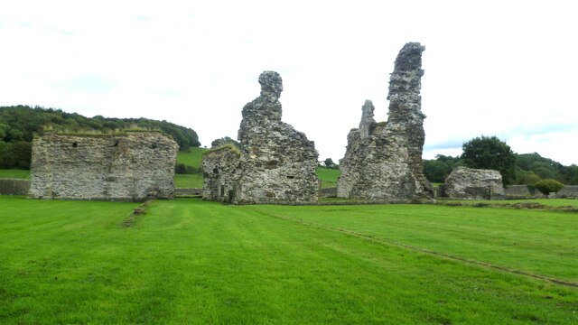
![Sawley village and abbey [2] The ruins of the abbey church.
Sawley is a small village on the banks of the River Ribble, some 3½ miles northeast of Clitheroe. The village is dominated by the ruins of the Cistercian abbey founded in 1148. The abbey was dissolved in 1536 and mostly demolished, the stone taken and reused in neighbouring farms and cottages. The ruins are now in the care of English Heritage. The abbey remains are listed, grade I, with details at: <span class="nowrap"><a title="https://historicengland.org.uk/listing/the-list/list-entry/1072099" rel="nofollow ugc noopener" href="https://historicengland.org.uk/listing/the-list/list-entry/1072099">Link</a><img style="margin-left:2px;" alt="External link" title="External link - shift click to open in new window" src="https://s1.geograph.org.uk/img/external.png" width="10" height="10"/></span> The site is a Scheduled Ancient Monument with much detail at: <span class="nowrap"><a title="https://historicengland.org.uk/listing/the-list/list-entry/1015492" rel="nofollow ugc noopener" href="https://historicengland.org.uk/listing/the-list/list-entry/1015492">Link</a><img style="margin-left:2px;" alt="External link" title="External link - shift click to open in new window" src="https://s1.geograph.org.uk/img/external.png" width="10" height="10"/></span>](https://s1.geograph.org.uk/geophotos/07/02/65/7026513_b5890db0.jpg)
![Sawley village and abbey [3] An information board about the abbey.
Sawley is a small village on the banks of the River Ribble, some 3½ miles northeast of Clitheroe. The village is dominated by the ruins of the Cistercian abbey founded in 1148. The abbey was dissolved in 1536 and mostly demolished, the stone taken and reused in neighbouring farms and cottages. The ruins are now in the care of English Heritage. The abbey remains are listed, grade I, with details at: <span class="nowrap"><a title="https://historicengland.org.uk/listing/the-list/list-entry/1072099" rel="nofollow ugc noopener" href="https://historicengland.org.uk/listing/the-list/list-entry/1072099">Link</a><img style="margin-left:2px;" alt="External link" title="External link - shift click to open in new window" src="https://s1.geograph.org.uk/img/external.png" width="10" height="10"/></span> The site is a Scheduled Ancient Monument with much detail at: <span class="nowrap"><a title="https://historicengland.org.uk/listing/the-list/list-entry/1015492" rel="nofollow ugc noopener" href="https://historicengland.org.uk/listing/the-list/list-entry/1015492">Link</a><img style="margin-left:2px;" alt="External link" title="External link - shift click to open in new window" src="https://s1.geograph.org.uk/img/external.png" width="10" height="10"/></span>](https://s3.geograph.org.uk/geophotos/07/02/65/7026515_6052e2c8.jpg)
![Sawley village and abbey [4] The ruins of some of the monk&#039;s accommodation.
Sawley is a small village on the banks of the River Ribble, some 3½ miles northeast of Clitheroe. The village is dominated by the ruins of the Cistercian abbey founded in 1148. The abbey was dissolved in 1536 and mostly demolished, the stone taken and reused in neighbouring farms and cottages. The ruins are now in the care of English Heritage. The abbey remains are listed, grade I, with details at: <span class="nowrap"><a title="https://historicengland.org.uk/listing/the-list/list-entry/1072099" rel="nofollow ugc noopener" href="https://historicengland.org.uk/listing/the-list/list-entry/1072099">Link</a><img style="margin-left:2px;" alt="External link" title="External link - shift click to open in new window" src="https://s1.geograph.org.uk/img/external.png" width="10" height="10"/></span> The site is a Scheduled Ancient Monument with much detail at: <span class="nowrap"><a title="https://historicengland.org.uk/listing/the-list/list-entry/1015492" rel="nofollow ugc noopener" href="https://historicengland.org.uk/listing/the-list/list-entry/1015492">Link</a><img style="margin-left:2px;" alt="External link" title="External link - shift click to open in new window" src="https://s1.geograph.org.uk/img/external.png" width="10" height="10"/></span>](https://s0.geograph.org.uk/geophotos/07/02/65/7026516_b62c5d29.jpg)
![Sawley village and abbey [5] The remains of part of the floor of the abbey church.
Sawley is a small village on the banks of the River Ribble, some 3½ miles northeast of Clitheroe. The village is dominated by the ruins of the Cistercian abbey founded in 1148. The abbey was dissolved in 1536 and mostly demolished, the stone taken and reused in neighbouring farms and cottages. The ruins are now in the care of English Heritage. The abbey remains are listed, grade I, with details at: <span class="nowrap"><a title="https://historicengland.org.uk/listing/the-list/list-entry/1072099" rel="nofollow ugc noopener" href="https://historicengland.org.uk/listing/the-list/list-entry/1072099">Link</a><img style="margin-left:2px;" alt="External link" title="External link - shift click to open in new window" src="https://s1.geograph.org.uk/img/external.png" width="10" height="10"/></span> The site is a Scheduled Ancient Monument with much detail at: <span class="nowrap"><a title="https://historicengland.org.uk/listing/the-list/list-entry/1015492" rel="nofollow ugc noopener" href="https://historicengland.org.uk/listing/the-list/list-entry/1015492">Link</a><img style="margin-left:2px;" alt="External link" title="External link - shift click to open in new window" src="https://s1.geograph.org.uk/img/external.png" width="10" height="10"/></span>](https://s1.geograph.org.uk/geophotos/07/02/65/7026517_7643acc2.jpg)
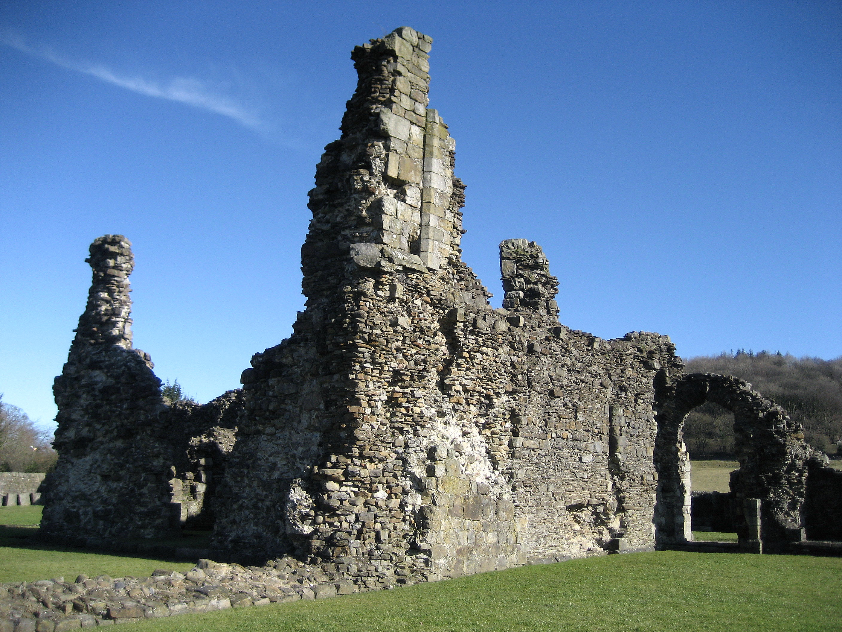
![Sawley village and abbey [6] The remains of the abbey church.
Sawley is a small village on the banks of the River Ribble, some 3½ miles northeast of Clitheroe. The village is dominated by the ruins of the Cistercian abbey founded in 1148. The abbey was dissolved in 1536 and mostly demolished, the stone taken and reused in neighbouring farms and cottages. The ruins are now in the care of English Heritage. The abbey remains are listed, grade I, with details at: <span class="nowrap"><a title="https://historicengland.org.uk/listing/the-list/list-entry/1072099" rel="nofollow ugc noopener" href="https://historicengland.org.uk/listing/the-list/list-entry/1072099">Link</a><img style="margin-left:2px;" alt="External link" title="External link - shift click to open in new window" src="https://s1.geograph.org.uk/img/external.png" width="10" height="10"/></span> The site is a Scheduled Ancient Monument with much detail at: <span class="nowrap"><a title="https://historicengland.org.uk/listing/the-list/list-entry/1015492" rel="nofollow ugc noopener" href="https://historicengland.org.uk/listing/the-list/list-entry/1015492">Link</a><img style="margin-left:2px;" alt="External link" title="External link - shift click to open in new window" src="https://s1.geograph.org.uk/img/external.png" width="10" height="10"/></span>](https://s3.geograph.org.uk/geophotos/07/02/65/7026519_f683a7e7.jpg)
![Sawley village and abbey [7] Fragments of carved stone in storage.
Sawley is a small village on the banks of the River Ribble, some 3½ miles northeast of Clitheroe. The village is dominated by the ruins of the Cistercian abbey founded in 1148. The abbey was dissolved in 1536 and mostly demolished, the stone taken and reused in neighbouring farms and cottages. The ruins are now in the care of English Heritage. The abbey remains are listed, grade I, with details at: <span class="nowrap"><a title="https://historicengland.org.uk/listing/the-list/list-entry/1072099" rel="nofollow ugc noopener" href="https://historicengland.org.uk/listing/the-list/list-entry/1072099">Link</a><img style="margin-left:2px;" alt="External link" title="External link - shift click to open in new window" src="https://s1.geograph.org.uk/img/external.png" width="10" height="10"/></span> The site is a Scheduled Ancient Monument with much detail at: <span class="nowrap"><a title="https://historicengland.org.uk/listing/the-list/list-entry/1015492" rel="nofollow ugc noopener" href="https://historicengland.org.uk/listing/the-list/list-entry/1015492">Link</a><img style="margin-left:2px;" alt="External link" title="External link - shift click to open in new window" src="https://s1.geograph.org.uk/img/external.png" width="10" height="10"/></span>](https://s0.geograph.org.uk/geophotos/07/02/65/7026520_b94ddb19.jpg)
![Sawley village and abbey [8] This delightful former school, which closed in 1976, is now the village hall.
Sawley is a small village on the banks of the River Ribble, some 3½ miles northeast of Clitheroe. The village is dominated by the ruins of the Cistercian abbey founded in 1148. The abbey was dissolved in 1536 and mostly demolished, the stone taken and reused in neighbouring farms and cottages. The ruins are now in the care of English Heritage.](https://s3.geograph.org.uk/geophotos/07/02/65/7026539_8fb6ee9f.jpg)

![Sawley village and abbey [9] A row of houses in rubble stone under a stone slate roof.
Sawley is a small village on the banks of the River Ribble, some 3½ miles northeast of Clitheroe. The village is dominated by the ruins of the Cistercian abbey founded in 1148. The abbey was dissolved in 1536 and mostly demolished, the stone taken and reused in neighbouring farms and cottages. The ruins are now in the care of English Heritage.](https://s0.geograph.org.uk/geophotos/07/02/65/7026548_2fc290cc.jpg)
Briery Bank Wood is located at Grid Ref: SD7847 (Lat: 53.926361, Lng: -2.3276168)
Division: West Riding
Administrative County: Lancashire
District: Ribble Valley
Police Authority: Lancashire
What 3 Words
///suggested.insurance.settle. Near Chatburn, Lancashire
Nearby Locations
Related Wikis

Skirden Beck
Skirden Beck is a minor river in Lancashire, England (historically in the West Riding of Yorkshire). It is approximately 4.3 miles (6.85 km) long and has...

St Peter and St Paul's Church, Bolton-by-Bowland
St Peter and St Paul's Church is in Gisburn Road, Bolton-by-Bowland, Lancashire, England. It is an active Anglican parish church in the deanery of Whalley...

Sawley, Lancashire
Sawley is a village and civil parish in the Borough of Ribble Valley in Lancashire, England. The population of the civil parish was 305 at the 2001 Census...

Bolton-by-Bowland
Bolton-by-Bowland is a village and civil parish in the Ribble Valley district of Lancashire, England. Before 1974, the village was part of Bowland Rural...
Sawley Abbey
Sawley Abbey was an abbey of Cistercian monks in the village of Sawley, Lancashire, in England (and historically in the West Riding of Yorkshire). Created...

Rimington railway station
Rimington railway station was a railway station that served the small village of Rimington in Lancashire. It was built by the Lancashire and Yorkshire...

Bowland High
Bowland High is a coeducational secondary school with academy status, located in Grindleton in Lancashire, England. It educates pupils from ages 11–16...

Rimington
Rimington is a rural village and civil parish in the Ribble Valley, Lancashire, England. The population of the civil parish was 382 at the 2001 Census...
Nearby Amenities
Located within 500m of 53.926361,-2.3276168Have you been to Briery Bank Wood?
Leave your review of Briery Bank Wood below (or comments, questions and feedback).