Ash Belt

Wood, Forest in Somerset

England

Ash Belt

Looking from the woods across the pool above the Lily Pond
Looking from the woods across the pool above the Lily Pond Credit: Rod Allday

Ash Belt, Somerset, also known as the Wood or Forest, is a picturesque area located in the county of Somerset, England. It is situated in the southwestern part of the country, near the town of Ashcott. Covering an area of approximately 10 square kilometers, Ash Belt is known for its dense ash tree population, hence the name.

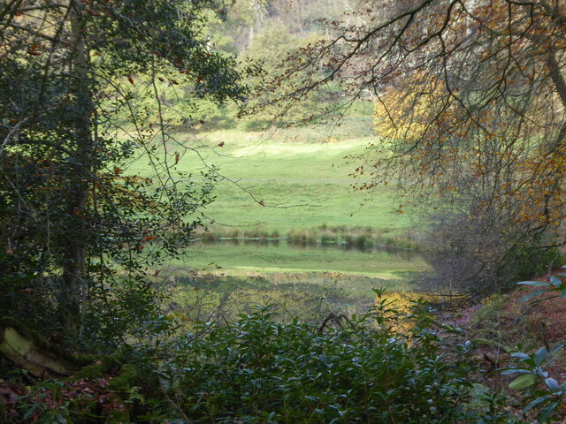
The landscape of Ash Belt is characterized by rolling hills, expansive woodlands, and meandering streams, creating a serene and tranquil atmosphere. The area is home to a diverse range of flora and fauna, including various species of birds, mammals, and insects. The lush greenery and vibrant wildflowers that bloom throughout the year make it a popular destination for nature enthusiasts and photographers.

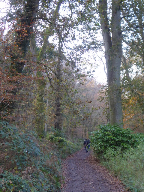
Walking trails and footpaths crisscross the forest, allowing visitors to explore the area and enjoy its natural beauty. The woodland is also a haven for outdoor activities such as hiking, wildlife spotting, and picnicking. Additionally, Ash Belt is home to several ancient monuments and archaeological sites, providing a glimpse into the region's rich history.

The forest is well-preserved and managed by local authorities, ensuring the conservation of its natural resources and wildlife. Visitors can find designated parking areas and information boards that provide details about the forest's history, wildlife, and safety guidelines.

Overall, Ash Belt, Somerset, is a captivating destination for those seeking a peaceful retreat in the lap of nature. With its breathtaking scenery, abundant wildlife, and opportunities for outdoor recreation, it continues to attract visitors from near and far.

If you have any feedback on the listing, please let us know in the comments section below.

Ash Belt Images

Images are sourced within 2km of 51.125284/-2.341264 or Grid Reference ST7636. Thanks to Geograph Open Source API. All images are credited.

Looking from the woods across the pool above the Lily Pond
Path through the woods by Six Wells Bottom
On Long Lane Sunken lane, overhung by an avenue of trees. The track is reduced to mud of a sloppy consistency in parts.
On Long Lane
Sunken lane, overhung by an avenue of trees. The track is reduced to mud of a sloppy consistency in parts.
Approaching Stourton Road, Kilmington Common On Tower Road as it approaches the community of Kilmington Common
Approaching Stourton Road, Kilmington Common
On Tower Road as it approaches the community of Kilmington Common
Ash Belt Strip of woodland heading north from Tower Road
Ash Belt
Strip of woodland heading north from Tower Road
Tower Road
Tower Road
Beside Tower Road on the Stourhead Estate
View Eastwards from the Base of King Alfred's Tower In the Stourhead Estate, National Trust
View Eastwards from the Base of King Alfred's Tower
In the Stourhead Estate, National Trust
A bench on Long Lane At last, the log offering somewhere to sit down and eat our lunch.
A bench on Long Lane
At last, the log offering somewhere to sit down and eat our lunch.
'Old Hunting Lodge' (66 Stourton Lane), Kilmington Common Listed Grade II <span class="nowrap"><a title="https://historicengland.org.uk/listing/the-list/list-entry/1199386?section=official-listing" rel="nofollow ugc noopener" href="https://historicengland.org.uk/listing/the-list/list-entry/1199386?section=official-listing">Link</a><img style="margin-left:2px;" alt="External link" title="External link - shift click to open in new window" src="https://s1.geograph.org.uk/img/external.png" width="10" height="10"/></span> . The datestone above the door reads 'HRH 1850', presumably referring to Sir Hugh Richard Hoare, then owner of the Stourhead Estate.
'Old Hunting Lodge' (66 Stourton Lane), Kilmington Common
Listed Grade II LinkExternal link . The datestone above the door reads 'HRH 1850', presumably referring to Sir Hugh Richard Hoare, then owner of the Stourhead Estate.
Six Wells Valley; source of the Stour St Peter's Pump, in the middle of the valley, is from the late 15th century, and originally stood near St Peter's church in Bristol, before being moved here in 1768 <span class="nowrap"><a title="https://historicengland.org.uk/listing/the-list/list-entry/1131107?section=official-listing" rel="nofollow ugc noopener" href="https://historicengland.org.uk/listing/the-list/list-entry/1131107?section=official-listing">Link</a><img style="margin-left:2px;" alt="External link" title="External link - shift click to open in new window" src="https://s1.geograph.org.uk/img/external.png" width="10" height="10"/></span>
Six Wells Valley; source of the Stour
St Peter's Pump, in the middle of the valley, is from the late 15th century, and originally stood near St Peter's church in Bristol, before being moved here in 1768 LinkExternal link
Entrance to The Terrace, above Six Wells Valley Footpath through National Trust property
Entrance to The Terrace, above Six Wells Valley
Footpath through National Trust property
Log piles, Stourhead Estate The woods are managed on a system called Continuous Cover Forestry, and sustainably produce 4000 tonnes of timber a year (local notice board)
Log piles, Stourhead Estate
The woods are managed on a system called Continuous Cover Forestry, and sustainably produce 4000 tonnes of timber a year (local notice board)
King Alfred's Tower A listed Grade I monument belonging to the National Trust. " ... a 160ft (49m) high folly, designed by Henry Flitcroft for Henry Hoare II in 1772. It is believed to mark the site where King Alfred the Great rallied his troops in 878. The tower commemorates the accession of George III to the throne in 1760 and the end of the Seven Years War." <span class="nowrap"><a title="https://www.nationaltrust.org.uk/stourhead/trails/stourhead-king-alfreds-tower-walk" rel="nofollow ugc noopener" href="https://www.nationaltrust.org.uk/stourhead/trails/stourhead-king-alfreds-tower-walk">Link</a><img style="margin-left:2px;" alt="External link" title="External link - shift click to open in new window" src="https://s1.geograph.org.uk/img/external.png" width="10" height="10"/></span>
And a convenient marker of the eastern end of the Leland Trail, which we will now follow to the west.
King Alfred's Tower
A listed Grade I monument belonging to the National Trust. " ... a 160ft (49m) high folly, designed by Henry Flitcroft for Henry Hoare II in 1772. It is believed to mark the site where King Alfred the Great rallied his troops in 878. The tower commemorates the accession of George III to the throne in 1760 and the end of the Seven Years War." LinkExternal link And a convenient marker of the eastern end of the Leland Trail, which we will now follow to the west.
New Road, Kilmington A straight stretch of road, seen looking in the other direction in <a href="https://www.geograph.org.uk/photo/3091732">ST7736 : 2012 : New Road near Kilmington</a>.
New Road, Kilmington
A straight stretch of road, seen looking in the other direction in ST7736 : 2012 : New Road near Kilmington.
Six Wells Bottom The dry valley route towards St Peter's Pump
Six Wells Bottom
The dry valley route towards St Peter's Pump
Terrace Cottage, Stourhead Estate
Track through the woods, Stourhead Taken from the Stour Valley Way, this view is outside the fenced gardens.
Track through the woods, Stourhead
Taken from the Stour Valley Way, this view is outside the fenced gardens.
Show me another place!

Ash Belt is located at Grid Ref: ST7636 (Lat: 51.125284, Lng: -2.341264)

Unitary Authority: Wiltshire

Police Authority: Wiltshire

What 3 Words

///whizzing.lure.uplifting. Near Kilmington, Wiltshire

Nearby Locations

The Belt Ash Belt

Related Wikis

Kilmington, Wiltshire

Kilmington is a village and civil parish in the extreme west of Wiltshire, England, about 8 miles (13 km) southwest of Warminster. The parish includes...

King Alfred's Tower

Alfred's Tower is a folly in Somerset, England, on the edge of the border with Wiltshire, on the Stourhead estate. The tower stands on Kingsettle Hill...

Nozarego

Nozarego is a village in the commune of Santa Margherita Ligure in Liguria, Italy. It is a natural terrace over the Bay of Tigullio. Here there is the...

Stourhead

Stourhead () is a 1,072-hectare (2,650-acre) estate at the source of the River Stour in the southwest of the English county of Wiltshire, extending into...

Have you been to Ash Belt?

Leave your review of Ash Belt below (or comments, questions and feedback).