Bridge House Wood

Wood, Forest in Yorkshire Ribble Valley

England

Bridge House Wood

River Hodder entering Stocks Reservoir The photo shows the point at which the River Hodder enters the Stocks Reservoir. The reservoir is at a particularly low level. It was opened in 1932 and supplies Blackpool and the Fylde coast. There are a number of waymarked forest walks and cycle routes. Trout fishing is available.
River Hodder entering Stocks Reservoir Credit: Rod Grealish

Bridge House Wood is a picturesque woodland located in the heart of Yorkshire, England. Spanning over an area of approximately 50 acres, this enchanting forest offers visitors a tranquil escape from the hustle and bustle of city life.

The wood is predominantly comprised of a mix of native trees, including oak, birch, and beech, which create a rich and diverse ecosystem. The dense canopy provides a cool and shaded environment, making it a perfect spot for leisurely walks or picnics on warm summer days.

As visitors explore the wood, they will come across a network of well-maintained footpaths that wind their way through the trees, allowing for easy access to the various areas of interest. These paths not only provide an opportunity for nature enthusiasts to observe the local flora and fauna but also offer a chance to spot some of the woodland's resident wildlife, such as squirrels, rabbits, and a variety of bird species.

For those with a keen interest in history, Bridge House Wood also features remnants of a medieval bridge that once spanned a nearby river. These ancient stone ruins add an extra layer of intrigue to the wood and serve as a reminder of the area's rich heritage.

Overall, Bridge House Wood is a hidden gem that showcases the natural beauty of Yorkshire. With its peaceful atmosphere, diverse wildlife, and historical significance, it is a must-visit destination for anyone seeking a peaceful retreat in the heart of nature.

If you have any feedback on the listing, please let us know in the comments section below.

Bridge House Wood Images

Images are sourced within 2km of 53.997713/-2.3995222 or Grid Reference SD7355. Thanks to Geograph Open Source API. All images are credited.

River Hodder entering Stocks Reservoir The photo shows the point at which the River Hodder enters the Stocks Reservoir. The reservoir is at a particularly low level. It was opened in 1932 and supplies Blackpool and the Fylde coast. There are a number of waymarked forest walks and cycle routes. Trout fishing is available.
River Hodder entering Stocks Reservoir
The photo shows the point at which the River Hodder enters the Stocks Reservoir. The reservoir is at a particularly low level. It was opened in 1932 and supplies Blackpool and the Fylde coast. There are a number of waymarked forest walks and cycle routes. Trout fishing is available.
Tosside, Marl Barn According to the OS benchmark database there was a cutmark in one of the gateposts at this location. The entrance has been widened with new wooden gateposts. There is also a new entrance to the left of this field entrance. The gateposts were checked but had no marks.
Tosside, Marl Barn
According to the OS benchmark database there was a cutmark in one of the gateposts at this location. The entrance has been widened with new wooden gateposts. There is also a new entrance to the left of this field entrance. The gateposts were checked but had no marks.
Tosside, B6478 The benchmark is cut into a right hand gatepost at a field entrance on the north side of the road.
Tosside, B6478
The benchmark is cut into a right hand gatepost at a field entrance on the north side of the road.
Tosside, B6478 There is a benchmark cut into the right hand gatepost at the field entrance on the north side of the road.
Tosside, B6478
There is a benchmark cut into the right hand gatepost at the field entrance on the north side of the road.
Tosside, B6478 The benchmark is cut into the roadside wall on the north side of the road, and the mark is directly at a wall junction which splits the fields.
Tosside, B6478
The benchmark is cut into the roadside wall on the north side of the road, and the mark is directly at a wall junction which splits the fields.
Tosside, B6478 There is a benchmark cut into the roadside wall on the north side of the road, and the mark is directly at a wall junction which splits the fields.
Tosside, B6478
There is a benchmark cut into the roadside wall on the north side of the road, and the mark is directly at a wall junction which splits the fields.
Tosside, Well House The OS Flush Bracket 10829 is embedded into the south-west facing gable end of Well House. The plate remains in very good condition, being protected by wheelie bins.
Tosside, Well House
The OS Flush Bracket 10829 is embedded into the south-west facing gable end of Well House. The plate remains in very good condition, being protected by wheelie bins.
Tosside, Stephen Moor crossroads The benchmark is cut into a right hand gatepost at a field entrance on the north side of B6478 and to the east of the crossroads.
Tosside, Stephen Moor crossroads
The benchmark is cut into a right hand gatepost at a field entrance on the north side of B6478 and to the east of the crossroads.
Tosside, Stephen Moor crossroads There is a benchmark cut into a right hand gatepost at the field entrance on the north side of B6478 and to the east of the crossroads.
Tosside, Stephen Moor crossroads
There is a benchmark cut into a right hand gatepost at the field entrance on the north side of B6478 and to the east of the crossroads.
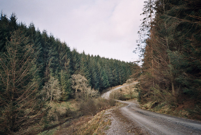
Gisburn Forest track A left turn to the north makes this easy-going teack a little harder as it is now gently uphill. Most of the forestry tracks are like this - low gradient and not too challenging for those on mountain bikes so old that suspension was not deemed necessary (at my age I want all the power I can generate to go into actual forward progress, not into compressing shock absorbers).
Gisburn Forest track
A left turn to the north makes this easy-going teack a little harder as it is now gently uphill. Most of the forestry tracks are like this - low gradient and not too challenging for those on mountain bikes so old that suspension was not deemed necessary (at my age I want all the power I can generate to go into actual forward progress, not into compressing shock absorbers).
Looking over Bottoms Beck A gap in the trees to the east of the track allows a view over Bottoms Beck to the clearing morning mists towards Hesbert Hall.
Looking over Bottoms Beck
A gap in the trees to the east of the track allows a view over Bottoms Beck to the clearing morning mists towards Hesbert Hall.
Hesbert Hall The forest track runs alongside a seriously thistle-infested field at Hesbert Hall with the extensive Gisburn Forest surrounding it - a few colouring larches, but mostly evergreen non-native conifers (Sitka spruce, Picea sitchensis, being the majority).
Hesbert Hall
The forest track runs alongside a seriously thistle-infested field at Hesbert Hall with the extensive Gisburn Forest surrounding it - a few colouring larches, but mostly evergreen non-native conifers (Sitka spruce, Picea sitchensis, being the majority).
Track at Moss End I seemed to be the only mountain biker using this track, which isn't really a through route for cyclists, but dog walkers using the public right of way can continue east to the minor road by deviating from the track before it meets a gate marked "private, no public access". This view looks back towards Skirden Hall Plantation and a route to join other forest tracks and bike trails.
Track at Moss End
I seemed to be the only mountain biker using this track, which isn't really a through route for cyclists, but dog walkers using the public right of way can continue east to the minor road by deviating from the track before it meets a gate marked "private, no public access". This view looks back towards Skirden Hall Plantation and a route to join other forest tracks and bike trails.
The entrance to Gisburn Forest Hub From Hole House Lane, which used to be a very quiet road, the entrance to Gisburn Forest Hub and the Stephen Park Centre now attracts a lot more traffic than when I last passed this way (probably over thirty years ago). The track leads to probably the biggest car park in the forest, and the sign suggest that it is not a free one (I didn't park here, so cannot vouch for this). Beyond the car park, the network of tracks become essentially traffic-free and is popular with moountain bikers.
The entrance to Gisburn Forest Hub
From Hole House Lane, which used to be a very quiet road, the entrance to Gisburn Forest Hub and the Stephen Park Centre now attracts a lot more traffic than when I last passed this way (probably over thirty years ago). The track leads to probably the biggest car park in the forest, and the sign suggest that it is not a free one (I didn't park here, so cannot vouch for this). Beyond the car park, the network of tracks become essentially traffic-free and is popular with moountain bikers.
Track to Brookhouse Green A brief break from mountain biking to nip down the track to Brookhouse Green and the square just beyond it on foot, as this is a public footpath, not a bridleway. A shower had just scudded past - enough to quickly don a waterproof, but not really enough to actually get wet, so it was back off in time for the rainbow which ensued a few minutes later.
Track to Brookhouse Green
A brief break from mountain biking to nip down the track to Brookhouse Green and the square just beyond it on foot, as this is a public footpath, not a bridleway. A shower had just scudded past - enough to quickly don a waterproof, but not really enough to actually get wet, so it was back off in time for the rainbow which ensued a few minutes later.
Track between Rain Gill and Brookhouse Green A brief sunny interlude after a short light shower gives nice light and shade on this farm track, looking towards Brookhouse Green and the way back to the minor road from Clapham to Slaidburn.
Track between Rain Gill and Brookhouse Green
A brief sunny interlude after a short light shower gives nice light and shade on this farm track, looking towards Brookhouse Green and the way back to the minor road from Clapham to Slaidburn.
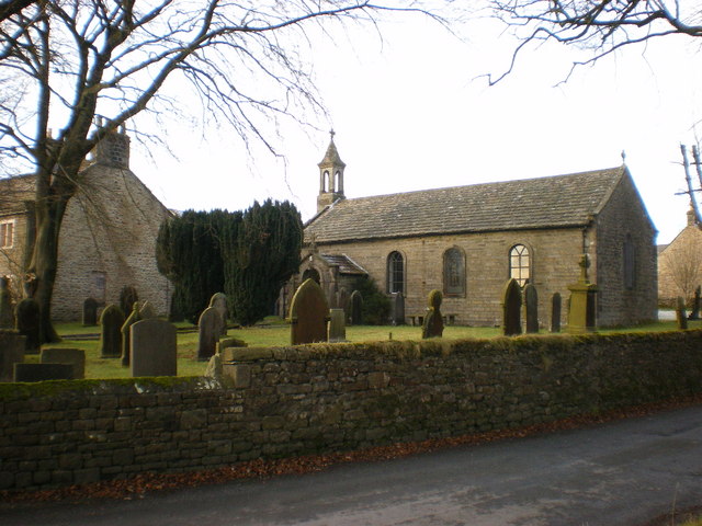
St. James' Church, Dalehead A sign by the path in, on the left (west) says "Dalehead Church and Heritage Centre". Heritage possibly doesn't need a lot of energy - the centre has a wind turbine, but it seems to be well below tree-top height, which must limit its ability to kick out power. On the bright side, not many people seem to die here - it's an extensive graveyard with very few headstones.
St. James' Church, Dalehead
A sign by the path in, on the left (west) says "Dalehead Church and Heritage Centre". Heritage possibly doesn't need a lot of energy - the centre has a wind turbine, but it seems to be well below tree-top height, which must limit its ability to kick out power. On the bright side, not many people seem to die here - it's an extensive graveyard with very few headstones.
Show me another place!

Bridge House Wood is located at Grid Ref: SD7355 (Lat: 53.997713, Lng: -2.3995222)

Division: West Riding

Administrative County: Lancashire

District: Ribble Valley

Police Authority: Lancashire

What 3 Words

///echo.storeroom.enrolling. Near Settle, North Yorkshire

Related Wikis

Easington, Lancashire

Easington () is a civil parish within the Ribble Valley district of Lancashire, England, with a population in 2001 of 52. The Census 2011 population details...

Stocks Reservoir

Stocks Reservoir is a reservoir situated at the head of the Hodder valley in the Forest of Bowland, Lancashire, England (historically in the West Riding...

Tosside

Tosside is a small village on the modern border of North Yorkshire and Lancashire in Northern England. It lies within the Forest of Bowland, and is between...

Gisburn Forest

Gisburn Forest is a civil parish in the Ribble Valley, in Lancashire, England. Mainly lying within the Forest of Bowland Area of Outstanding Natural Beauty...

Nearby Amenities

Located within 500m of 53.997713,-2.3995222
Barrier: kissing_gate
Lat/Long: 53.9997093/-2.4021735
The data included in this document is from www.openstreetmap.org. The data is made available under ODbL.

Have you been to Bridge House Wood?

Leave your review of Bridge House Wood below (or comments, questions and feedback).