Bector Wood

Wood, Forest in Somerset Mendip

England

Bector Wood

The Kings Head, Coleford Opened in the seventeenth century and retaining many period features, the inn carries on offering a warm welcome. A sign relates that it was badly damaged by a fire but rebuilt in 1830.
The Kings Head, Coleford Credit: Neil Owen

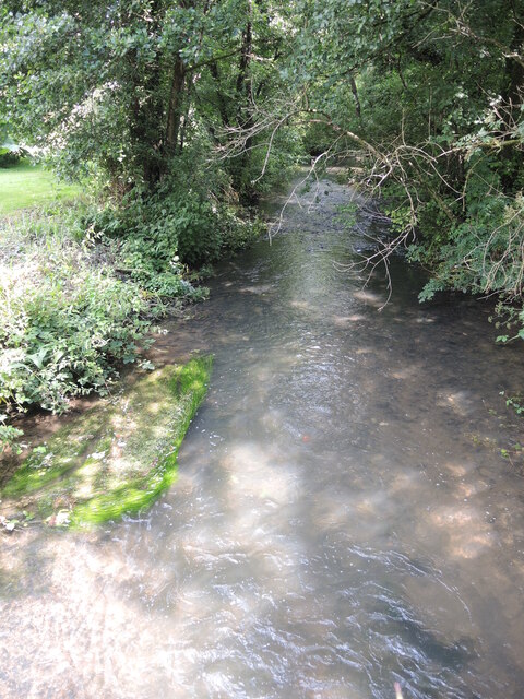
Bector Wood is a picturesque forest located in Somerset, England. It is known for its natural beauty and serene atmosphere, making it a popular destination for nature lovers and hikers alike. The wood covers an area of approximately 100 acres and is home to a diverse range of flora and fauna.

The wood is characterized by its dense tree cover, comprising mainly of oak, beech, and ash trees. These tall and majestic trees provide a canopy of shade, creating a cool and peaceful environment within the wood. In spring, the forest floor is carpeted with bluebells, creating a stunning display of color.

The wood is crisscrossed with several well-maintained trails, allowing visitors to explore its various nooks and corners. These trails cater to individuals of all fitness levels, with options for leisurely strolls as well as more challenging hikes. Along the way, visitors might spot a variety of wildlife, including deer, squirrels, and various bird species.

Bector Wood also has a rich history, dating back several centuries. It has been used for timber production, providing a valuable resource for the local community. In addition, the wood has served as a recreational space for generations, offering a tranquil sanctuary away from the hustle and bustle of everyday life.

Overall, Bector Wood is a hidden gem in Somerset, offering visitors a chance to immerse themselves in nature and experience the beauty of a well-preserved forest. Its serene ambiance, diverse wildlife, and scenic trails make it a must-visit destination for anyone seeking solace in the great outdoors.

If you have any feedback on the listing, please let us know in the comments section below.

Bector Wood Images

Images are sourced within 2km of 51.227829/-2.468535 or Grid Reference ST6747. Thanks to Geograph Open Source API. All images are credited.

The Kings Head, Coleford Opened in the seventeenth century and retaining many period features, the inn carries on offering a warm welcome. A sign relates that it was badly damaged by a fire but rebuilt in 1830.
The Kings Head, Coleford
Opened in the seventeenth century and retaining many period features, the inn carries on offering a warm welcome. A sign relates that it was badly damaged by a fire but rebuilt in 1830.
The Mells Stream at Coleford Busily flowing down towards Frome.
The Mells Stream at Coleford
Busily flowing down towards Frome.
Walk steadily over the stream No railings for this wooden (and somewhat slippery) footbridge. It crosses the tributary that runs down from Kilmersdon Common to meet the Mells Stream.
Walk steadily over the stream
No railings for this wooden (and somewhat slippery) footbridge. It crosses the tributary that runs down from Kilmersdon Common to meet the Mells Stream.
A dream that ran dry This is the Coleford aqueduct - part of the grand scheme to build the Dorset and Somerset Canal in the late eighteenth century. The plan was to link the Kennet and Avon Canal to Poole in Dorset, with some work being completed before the money dried up. It was never finished and the parts near here that did open were known locally as the Hucky Duck. Here a twin-arch section near Coleford spans private property.
A dream that ran dry
This is the Coleford aqueduct - part of the grand scheme to build the Dorset and Somerset Canal in the late eighteenth century. The plan was to link the Kennet and Avon Canal to Poole in Dorset, with some work being completed before the money dried up. It was never finished and the parts near here that did open were known locally as the Hucky Duck. Here a twin-arch section near Coleford spans private property.
Hucky Duck aqueduct Despite never being completed fully, the old Dorset and Somerset Canal aqueduct (known as the Hucky Duck) stands as a testament to the dream.
Hucky Duck aqueduct
Despite never being completed fully, the old Dorset and Somerset Canal aqueduct (known as the Hucky Duck) stands as a testament to the dream.
Steep steps to the bottom Coleford is based around a steep slope that follows the Mells Stream into the valley. Church Road winds its way up and then turns sharply back up the hillside. Between this hairpin is a flight of steps with a noticeboard.
Steep steps to the bottom
Coleford is based around a steep slope that follows the Mells Stream into the valley. Church Road winds its way up and then turns sharply back up the hillside. Between this hairpin is a flight of steps with a noticeboard.
Benchmark in Coleford High Street This cutmark on a house in High Street is listed in the Benchmark Database: <span class="nowrap"><a title="https://www.bench-marks.org.uk/bm161491" rel="nofollow ugc noopener" href="https://www.bench-marks.org.uk/bm161491">Link</a><img style="margin-left:2px;" alt="External link" title="External link - shift click to open in new window" src="https://s1.geograph.org.uk/img/external.png" width="10" height="10"/></span> . See <a href="https://www.geograph.org.uk/photo/7060944">ST6848 : The end of High Street</a> for a wider view.
Benchmark in Coleford High Street
This cutmark on a house in High Street is listed in the Benchmark Database: LinkExternal link . See ST6848 : The end of High Street for a wider view.
The end of High Street The street meets the steep hairpin of Church Road. On the house to the right of shot is an old benchmark - see <a href="https://www.geograph.org.uk/photo/7060938">ST6848 : Benchmark in Coleford High Street</a>.
The end of High Street
The street meets the steep hairpin of Church Road. On the house to the right of shot is an old benchmark - see ST6848 : Benchmark in Coleford High Street.
End wall of Laurel Cottage This old home bears a cut benchmark at the corner - see <a href="https://www.geograph.org.uk/photo/7060952">ST6849 : Benchmark on a cottage in Church Street</a>.
End wall of Laurel Cottage
This old home bears a cut benchmark at the corner - see ST6849 : Benchmark on a cottage in Church Street.
Benchmark on a cottage in Church Street Previously known as Church Lane, this cottage has a benchmark - see <span class="nowrap"><a title="https://www.bench-marks.org.uk/bm161494" rel="nofollow ugc noopener" href="https://www.bench-marks.org.uk/bm161494">Link</a><img style="margin-left:2px;" alt="External link" title="External link - shift click to open in new window" src="https://s1.geograph.org.uk/img/external.png" width="10" height="10"/></span> for the entry in the Benchmark Database and <a href="https://www.geograph.org.uk/photo/7060950">ST6849 : End wall of Laurel Cottage</a> for a wider view.
Benchmark on a cottage in Church Street
Previously known as Church Lane, this cottage has a benchmark - see LinkExternal link for the entry in the Benchmark Database and ST6849 : End wall of Laurel Cottage for a wider view.
Entrance to Coleford Playing Fields The gates bear memorials to the fallen of the World Wars. They also bear a plaque that states the fields were given a grant from the National Playing Fields Association.
Entrance to Coleford Playing Fields
The gates bear memorials to the fallen of the World Wars. They also bear a plaque that states the fields were given a grant from the National Playing Fields Association.
For the kids on Coleford Some play equipment and a football pitch form the open space in the village.
For the kids on Coleford
Some play equipment and a football pitch form the open space in the village.
The old Sunday School Coleford school, built 1843, next to the Wesleyan Methodist church. It is now a private residence.
The old Sunday School
Coleford school, built 1843, next to the Wesleyan Methodist church. It is now a private residence.
Coleford Wesleyan Methodist chapel Founded in 1865.
Coleford Wesleyan Methodist chapel
Founded in 1865.
Coleford village hall The hall has a datestone of 1963, but it appears to have been a welfare institute before that - for at least a few decades.
Coleford village hall
The hall has a datestone of 1963, but it appears to have been a welfare institute before that - for at least a few decades.
Holy Trinity, Coleford The village church was designed by J. Sperring in 1831. Grade II listed.
Holy Trinity, Coleford
The village church was designed by J. Sperring in 1831. Grade II listed.
A fresh air conveyor A piece of agricultural machinery in a field at the back of the church seems a little neglected.
A fresh air conveyor
A piece of agricultural machinery in a field at the back of the church seems a little neglected.
The church of the Holy Trinity from the west Looking from the small but pleasant graveyard to the church.
The church of the Holy Trinity from the west
Looking from the small but pleasant graveyard to the church.
Show me another place!

Bector Wood is located at Grid Ref: ST6747 (Lat: 51.227829, Lng: -2.468535)

Administrative County: Somerset

District: Mendip

Police Authority: Avon and Somerset

What 3 Words

///traders.balconies.heartless. Near Chilcompton, Somerset

Nearby Locations

Bector Wood

Related Wikis

Cook's Wood Quarry

Cook's Wood Quarry also known as Holcombe Quarry (grid reference ST669479) is a 0.8-hectare (2.0-acre) geological Site of Special Scientific Interest near...

Stoke Lane Slocker

Stoke Lane Slocker (grid reference ST66874745) is a cave near Stoke St Michael, in the Carboniferous Limestone of the Mendip Hills, in the English county...

St Dunstan's Well Catchment

St. Dunstan's Well Catchment (grid reference ST668475) is a Site of Special Scientific Interest, covering 39.8 hectares (98.3 acres) near Stoke St Michael...

Edford Woods and Meadows

Edford Woods and Meadows (grid reference ST665485) is a 54.3 hectare (134.1 acre) biological Site of Special Scientific Interest, between Nettlebridge...

Stoke St Michael

Stoke St Michael is a village and civil parish on the Mendip Hills 4 miles (6.4 km) north east of Shepton Mallet, and 8 miles (12.9 km) west of Frome,...

Church of St Michael, Stoke St Michael

The Anglican Church of St Michael in Stoke St Michael, Somerset, England was built around 1400. It is a Grade II* listed building. == History == The western...

W/L Cave

W/L Cave is part of the Fairy Cave Quarry group of caves between Stoke St Michael and Oakhill in the limestone of the Mendip Hills, in Somerset, England...
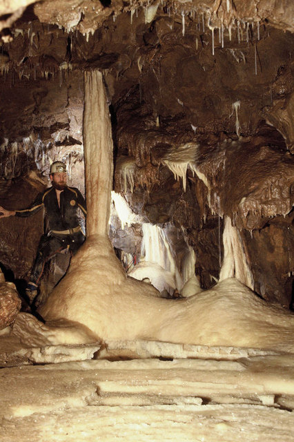
Shatter Cave

Shatter Cave is a cave in Fairy Cave Quarry, near Stoke St Michael in the limestone of the Mendip Hills, in Somerset, England. It falls within the St....

Have you been to Bector Wood?

Leave your review of Bector Wood below (or comments, questions and feedback).