Vale Royal Wood

Wood, Forest in Cheshire

England

Vale Royal Wood

Parish Church of St. Stephen Moulton
Parish Church of St. Stephen Moulton Credit: David Marten

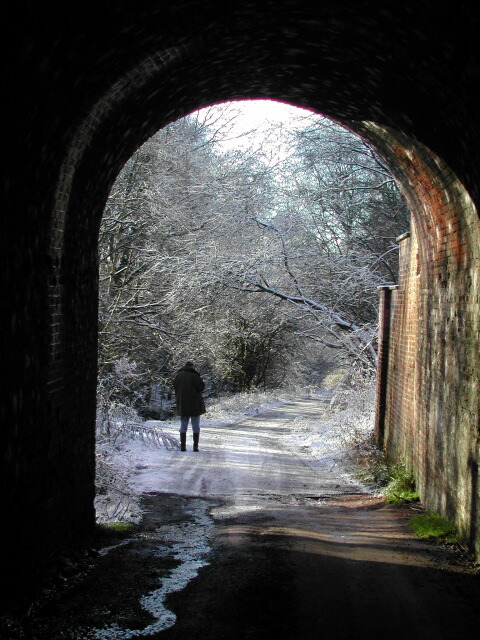
Vale Royal Wood, located in the county of Cheshire, England, is a picturesque woodland that covers an area of approximately 380 hectares. It is situated in the Vale Royal district, near the village of Whitegate, and is part of the larger Delamere Forest.

The woodland is predominantly composed of mixed deciduous trees, including oak, birch, beech, and pine, which create a diverse and vibrant environment. The forest floor is covered with a rich carpet of ferns, bluebells, and other wildflowers, offering a beautiful display throughout the year.

Vale Royal Wood is not only renowned for its natural beauty but also for its historical significance. It was originally part of the hunting grounds of the medieval Royal Forest of Mara and Mondrem, which was later transformed into a deer park during the reign of King Edward I. The remnants of the medieval deer park can still be seen in the form of earthworks and banks within the woodland.

Today, Vale Royal Wood is a popular destination for nature enthusiasts, walkers, and cyclists. The forest offers a network of well-maintained trails and paths, allowing visitors to explore its hidden corners and discover its abundant wildlife, including deer, squirrels, and a variety of bird species.

Additionally, the wood is home to several recreational facilities, including picnic areas, a visitor center, and a café, providing amenities for visitors to relax and enjoy the tranquil surroundings. Vale Royal Wood truly offers a peaceful escape into nature, where visitors can immerse themselves in the beauty of Cheshire's countryside.

If you have any feedback on the listing, please let us know in the comments section below.

Vale Royal Wood Images

Images are sourced within 2km of 53.235278/-2.5353125 or Grid Reference SJ6471. Thanks to Geograph Open Source API. All images are credited.

Parish Church of St. Stephen Moulton
The Lion Lion Public House on Main Road Moulton. As always in these places, directly opposite the Church.
The Lion
Lion Public House on Main Road Moulton. As always in these places, directly opposite the Church.
Travellers Rest Moulton Travellers Rest Public house on the junction of Main Road and Whitlow Lane Moulton.

Sadly this pub looks somewhat run down in an otherwise pleasant little village. Initially thought it to be closed down but there did seemm to be some regulars using it.
Travellers Rest Moulton
Travellers Rest Public house on the junction of Main Road and Whitlow Lane Moulton. Sadly this pub looks somewhat run down in an otherwise pleasant little village. Initially thought it to be closed down but there did seemm to be some regulars using it.
War Memorial Moulton War Memorial Main Road Moulton
War Memorial Moulton
War Memorial Main Road Moulton
Post Office Moulton Post Office on the corner of Main Road and Regent Street.
Post Office Moulton
Post Office on the corner of Main Road and Regent Street.
Path near Vale Royal Abbey Broad field-edge path to the East of Vale Royal Abbey. The path emerges from the other side of the wood onto the banks of the original course of the River Weaver.
Path near Vale Royal Abbey
Broad field-edge path to the East of Vale Royal Abbey. The path emerges from the other side of the wood onto the banks of the original course of the River Weaver.
Children's play area Children's play area beside Moulton village car park.
Children's play area
Children's play area beside Moulton village car park.
Under the old railway arch, by Caravan Park, Moulton
Vale Royal Abbey Golf Club house The Club house was built on the site of what was England's largest Cistercian Abbey, founded by Edward I, who in 1277 laid the first foundation stone. It took a further 53 years to complete the Abbey. When constructed, the Abbey was larger than Westminster Abbey. In the 16th century, following Henry VIII's Reformation and Dissolution of the Monasteries Acts, Thomas Holdcroft purchased the estate and pulled down the Abbey and built the Great House.
Vale Royal Abbey Golf Club house
The Club house was built on the site of what was England's largest Cistercian Abbey, founded by Edward I, who in 1277 laid the first foundation stone. It took a further 53 years to complete the Abbey. When constructed, the Abbey was larger than Westminster Abbey. In the 16th century, following Henry VIII's Reformation and Dissolution of the Monasteries Acts, Thomas Holdcroft purchased the estate and pulled down the Abbey and built the Great House.
The Traveller's Rest, Moulton
9 Chapel Lane An extended cottage
9 Chapel Lane
An extended cottage
Chapel Lane, looking south west
Chapel Lane looking north east
8 Chapel Lane
8 Chapel Lane
River Weaver Navigation and pond Weaver Navigation is on the left and a linear pond right, with a large flock of seagulls sitting still and quiet for a change. This is a pleasant stretch of path with some Herons to be seen.
River Weaver Navigation and pond
Weaver Navigation is on the left and a linear pond right, with a large flock of seagulls sitting still and quiet for a change. This is a pleasant stretch of path with some Herons to be seen.
Sluice at Vale Royal on the Weaver Navigation The Weaver Navigation splits here and the overflow has a sluice. It is vaguely gothic and built in stone.
Sluice at Vale Royal on the Weaver Navigation
The Weaver Navigation splits here and the overflow has a sluice. It is vaguely gothic and built in stone.
River Weaver Navigation
Path at Vale Royal The path here across an open field is only marked by mature trees, perhaps the remnant of a long since disappeared hedge?
Path at Vale Royal
The path here across an open field is only marked by mature trees, perhaps the remnant of a long since disappeared hedge?
Show me another place!

Vale Royal Wood is located at Grid Ref: SJ6471 (Lat: 53.235278, Lng: -2.5353125)

Unitary Authority: Cheshire West and Chester

Police Authority: Cheshire

What 3 Words

///showcase.hound.bloodshot. Near Hartford, Cheshire

Related Wikis

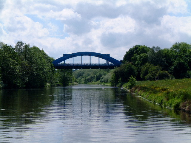
Hartford Bridge, Cheshire

The Hartford Bridge, or Blue Bridge, is a single-span road bridge crossing the River Weaver at Hartford, Cheshire in England. The bridge is located on...

Vale Royal Abbey

Vale Royal Abbey is a former medieval abbey and later country house in Whitegate, England. The precise location and boundaries of the abbey are difficult...

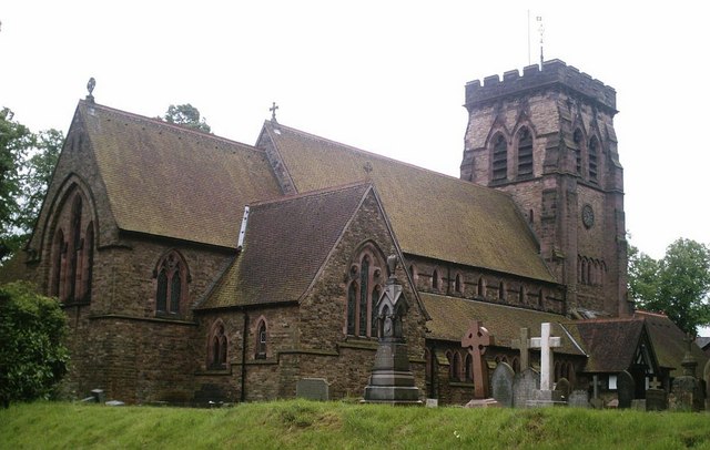
St John's Church, Hartford

St John the Baptist Church, is in the village of Hartford, Cheshire, England. The church is recorded in the National Heritage List for England as a designated...

Kingsmead, Cheshire

Kingsmead is a residential development and civil parish in the Cheshire West and Chester district, Cheshire, England, located on the eastern bank of the...

Nearby Amenities

Located within 500m of 53.235278,-2.5353125
Barrier: kissing_gate
Lat/Long: 53.2370145/-2.5358051
Crossing
Crossing: traffic_signals
Crossing Island: yes
Crossing Ref: toucan
Tactile Paving: yes
Lat/Long: 53.2388034/-2.536193
Barrier: kissing_gate
Source: Local knowledge
Lat/Long: 53.2373666/-2.5305893
Power: tower
Lat/Long: 53.2343713/-2.5383946
Power: pole
Lat/Long: 53.2308864/-2.5352318
Power: tower
Lat/Long: 53.2339348/-2.5359423
Power: tower
Lat/Long: 53.2355079/-2.5403419
Power: tower
Lat/Long: 53.2315711/-2.5358097
Power: tower
Lat/Long: 53.2318862/-2.5341513
Barrier: kissing_gate
Lat/Long: 53.2380787/-2.530235
Traffic Signals
Lat/Long: 53.2385789/-2.5362593
Crossing
Crossing: traffic_signals
Crossing Island: yes
Crossing Ref: toucan
Tactile Paving: yes
Lat/Long: 53.2385808/-2.5363315
Traffic Signals
Lat/Long: 53.2386387/-2.536017
Crossing
Crossing: traffic_signals
Crossing Island: yes
Crossing Ref: toucan
Tactile Paving: yes
Lat/Long: 53.2387221/-2.5364653
Traffic Signals
Lat/Long: 53.2387231/-2.5365331
Crossing
Crossing: traffic_signals
Crossing Island: yes
Crossing Ref: toucan
Tactile Paving: yes
Lat/Long: 53.2388041/-2.5360002
Traffic Signals
Lat/Long: 53.2388249/-2.5360506
Crossing
Crossing: unmarked
Crossing Island: no
Tactile Paving: no
Lat/Long: 53.2383503/-2.5323757
Power: tower
Lat/Long: 53.2342221/-2.5386293
Power: pole
Lat/Long: 53.2358961/-2.5395386
Power: pole
Lat/Long: 53.2366234/-2.5407716
Leisure: picnic_table
Lat/Long: 53.2337351/-2.5345743
The data included in this document is from www.openstreetmap.org. The data is made available under ODbL.

Have you been to Vale Royal Wood?

Leave your review of Vale Royal Wood below (or comments, questions and feedback).