Banty Gill Wood

Wood, Forest in Yorkshire South Lakeland

England

Banty Gill Wood

Stile, Firbank Fell A gap stile where a path leaves the road.
Stile, Firbank Fell Credit: Richard Webb

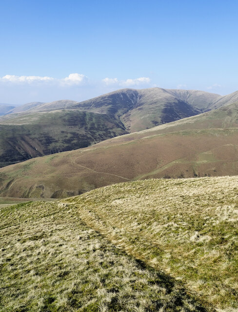
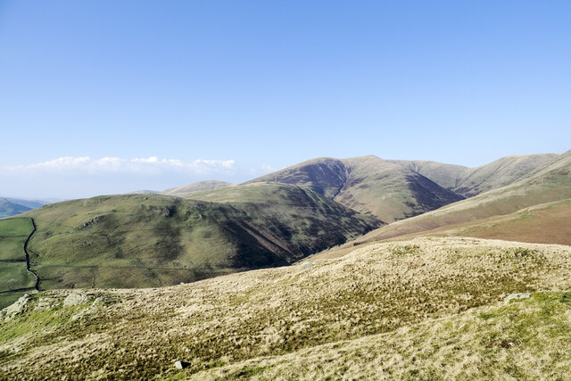
Banty Gill Wood is a picturesque forest situated in Yorkshire, England. With its lush greenery and diverse wildlife, it is a popular destination for nature enthusiasts and hikers alike. Spanning over several hectares, the wood is a serene retreat that offers tranquility and a chance to reconnect with nature.

The wood is known for its dense canopy of ancient oak, beech, and ash trees, which provide a cool and shaded environment, especially during the hot summer months. The forest floor is carpeted with a variety of wildflowers, creating a vibrant and colorful display during the spring and summer seasons.

Banty Gill Wood is home to a wide range of wildlife, making it a haven for animal lovers and birdwatchers. Visitors may spot deer, badgers, foxes, and an array of bird species, including woodpeckers, robins, and owls. The wood is particularly renowned for its population of red squirrels, which are a rare sight in many parts of the country.

The forest offers several well-maintained walking trails, allowing visitors to explore the wood at their own pace. These trails lead to hidden glades, babbling brooks, and peaceful ponds, offering opportunities for relaxation and contemplation. The wood also boasts a picnic area, where visitors can enjoy a packed lunch while surrounded by the beauty of nature.

Banty Gill Wood is an important natural habitat and is protected by local conservation efforts. Its diverse ecosystem and serene atmosphere make it a cherished destination for those seeking a peaceful escape from the hustle and bustle of everyday life.

If you have any feedback on the listing, please let us know in the comments section below.

Banty Gill Wood Images

Images are sourced within 2km of 54.349864/-2.564856 or Grid Reference SD6395. Thanks to Geograph Open Source API. All images are credited.

Stile, Firbank Fell A gap stile where a path leaves the road.
Stile, Firbank Fell
A gap stile where a path leaves the road.
Firbank Fell Used by the Westmorland Motor Club, but quiet today.
Firbank Fell
Used by the Westmorland Motor Club, but quiet today.
Crooked tree behind Fox's Pulpit A very attractive bit of moorland with complex contours.
Crooked tree behind Fox's Pulpit
A very attractive bit of moorland with complex contours.
Summit, Knotts A view of the Howgill Fells.
Summit, Knotts
A view of the Howgill Fells.
Castley A farm at the foot of Fell Head.
Castley
A farm at the foot of Fell Head.
Tarnhouse Barn
Tarnhouse Barn
Fields around the Chapel Beck The chapel which gives its name to the beck is on the right.
Fields around the Chapel Beck
The chapel which gives its name to the beck is on the right.
Knotts The summit area.
Knotts
The summit area.
Road over Firbank Fell Taken during a scenic detour due to the M6 being closed. It was raining hard. View towards Fox's Pulpit.
Road over Firbank Fell
Taken during a scenic detour due to the M6 being closed. It was raining hard. View towards Fox's Pulpit.
Path along ridge descending north The descending ground began as the west ridge of Arant Haw before splitting, this branch then turned north. It descends further then loses its identity.
Fell Head is the obvious distant hill.
Path along ridge descending north
The descending ground began as the west ridge of Arant Haw before splitting, this branch then turned north. It descends further then loses its identity. Fell Head is the obvious distant hill.
Knolls of Seat Knott Seat Knott is a feature of the declining west ridge of Arant Haw once it has gone through a few changes of direction.
Fell Head is the distant hill.
Knolls of Seat Knott
Seat Knott is a feature of the declining west ridge of Arant Haw once it has gone through a few changes of direction. Fell Head is the distant hill.
Farm road north-east of Birkhaw The farm road is also a bridleway heading into the valley of Bram Rigg Beck.
Farm road north-east of Birkhaw
The farm road is also a bridleway heading into the valley of Bram Rigg Beck.
Blue tractors parked at Birkhaw Birkhaw is a farm at the western side of the Howgill Fells.
Both machines appear to be Fords.
Blue tractors parked at Birkhaw
Birkhaw is a farm at the western side of the Howgill Fells. Both machines appear to be Fords.
The road to Craggstone OS maps give the name Craggstone for the property along this road but the photographer's memory is of the name Merlin Crag at the road end from where the image was made.
The road to Craggstone
OS maps give the name Craggstone for the property along this road but the photographer's memory is of the name Merlin Crag at the road end from where the image was made.
The road to High Branthwaite Branthwaite is in the valley of the River Lune, on the lower slopes of Winder in the Howgill Fells.
The road to High Branthwaite
Branthwaite is in the valley of the River Lune, on the lower slopes of Winder in the Howgill Fells.
Three sheep grazing Contented animals in a field on the north-east side of Howgill Lane near to Sedbergh.
Arant Haw is the hill beyond.
Three sheep grazing
Contented animals in a field on the north-east side of Howgill Lane near to Sedbergh. Arant Haw is the hill beyond.
Boundary Marker Cast-iron county bridge marker at SE end of Crook of Lune Bridge. 'WR' on both faces.

Milestone Society National ID: YW_SEDB05br
Boundary Marker
Cast-iron county bridge marker at SE end of Crook of Lune Bridge. 'WR' on both faces. Milestone Society National ID: YW_SEDB05br
Fox's Pulpit
Fox's Pulpit
Show me another place!

Banty Gill Wood is located at Grid Ref: SD6395 (Lat: 54.349864, Lng: -2.564856)

Division: West Riding

Administrative County: Cumbria

District: South Lakeland

Police Authority: Cumbria

What 3 Words

///laws.conspired.fade. Near Sedbergh, Cumbria

Related Wikis

Holy Trinity Church, Howgill

Holy Trinity Church stands in a country lane near the hamlet of Howgill, between Sedbergh and Tebay, Cumbria, England. It is an active Anglican church...

Firbank

Firbank is a village and civil parish in the South Lakeland district of the English county of Cumbria. It has a population of 97. As Firbank had a population...

Beck Foot

Beck Foot is a hamlet in Cumbria, England, situated on the B6257 road south of Lowgill, the West Coast Main Line and M6 motorway. The disused Lowgill Viaduct...

Low Gill railway station

Low Gill railway station served the hamlet of Lowgill, Westmorland (now in Cumbria), England, from 1846 to 1966 on the Lancaster and Carlisle Railway....

Nearby Amenities

Located within 500m of 54.349864,-2.564856
Post Box
Post Box Type: wall
Postal Code: LA10
Ref: LA10 193
Source: survey
Lat/Long: 54.3496203/-2.5639924
Telephone
Booth: K6
Covered: booth
Listed Status: Grade II
Lat/Long: 54.3494316/-2.5647264
Beckside
Place: farm
Source Name: OS_OpenData_StreetView
Lat/Long: 54.3487349/-2.5699894
Barrier: entrance
Lat/Long: 54.3481971/-2.5716805
Fixme: Line continues
Power: pole
Lat/Long: 54.3486528/-2.5713198
Power: pole
Lat/Long: 54.3517009/-2.5694263
Power: pole
Lat/Long: 54.3519677/-2.5685656
Power: pole
Lat/Long: 54.3523109/-2.567337
Power: pole
Lat/Long: 54.3526314/-2.5660409
Power: pole
Lat/Long: 54.3530013/-2.564525
Power: pole
Lat/Long: 54.3486911/-2.5678021
Power: pole
Lat/Long: 54.3490152/-2.5693026
Power: pole
Lat/Long: 54.3502425/-2.5689203
Power: pole
Lat/Long: 54.352486/-2.5698382
Power: pole
Lat/Long: 54.3502878/-2.5670907
Power: pole
Lat/Long: 54.3503164/-2.5656862
Power: pole
Lat/Long: 54.3503533/-2.5642838
Power: pole
Lat/Long: 54.3503938/-2.5626586
Power: pole
Lat/Long: 54.3499387/-2.5622068
Power: pole
Lat/Long: 54.3471969/-2.5595491
The data included in this document is from www.openstreetmap.org. The data is made available under ODbL.

Have you been to Banty Gill Wood?

Leave your review of Banty Gill Wood below (or comments, questions and feedback).