Corby Glen

Settlement in Lincolnshire South Kesteven

England

Corby Glen

Sugar beet and farm building near Corby Glen The East Coast Main Line crosses the picture behind the farm building.
Sugar beet and farm building near Corby Glen Credit: Jonathan Thacker

Corby Glen is a charming village located in the South Kesteven district of Lincolnshire, England. Situated about 10 miles south of Grantham, it is nestled in the heart of the picturesque countryside. The village is known for its rich history, stunning architecture, and vibrant community.

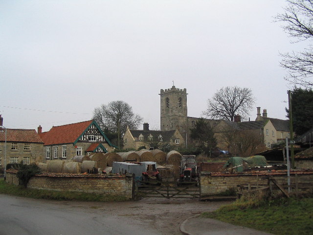
One of the notable landmarks in Corby Glen is the Grade I listed St. John the Evangelist Church. Dating back to the 13th century, this magnificent church features intricate stained glass windows and a beautiful stone tower. Another architectural gem in the village is the Corby Glen Watermill, a restored 19th-century mill that now serves as a popular tourist attraction.

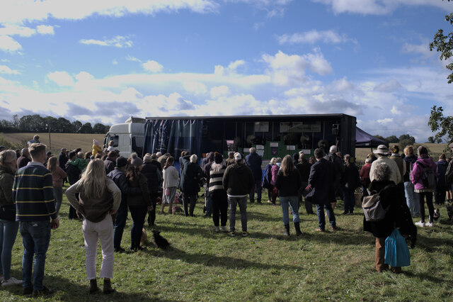
The village is home to a range of amenities, including a primary school, post office, and a selection of shops and restaurants. The local community is active and engaged, with various clubs and societies offering opportunities for residents to come together and socialize.

Corby Glen is surrounded by stunning countryside, making it an ideal location for outdoor enthusiasts. There are several walking and cycling trails in the area, providing ample opportunities to explore the natural beauty of the region. The nearby Bourne Woods also offer a tranquil escape for nature lovers.

Overall, Corby Glen is a delightful village that combines a rich history with a thriving community spirit. Its picturesque setting, architectural heritage, and range of amenities make it an appealing place to live or visit in Lincolnshire.

If you have any feedback on the listing, please let us know in the comments section below.

Corby Glen Images

Images are sourced within 2km of 52.811748/-0.518747 or Grid Reference SK9924. Thanks to Geograph Open Source API. All images are credited.

Sugar beet and farm building near Corby Glen The East Coast Main Line crosses the picture behind the farm building.
Sugar beet and farm building near Corby Glen
The East Coast Main Line crosses the picture behind the farm building.
Roadway near Corby Glen Prior to the creation of the underbridge just to the north this was the main road from Colsterworth to Bourne.
Roadway near Corby Glen
Prior to the creation of the underbridge just to the north this was the main road from Colsterworth to Bourne.
Field of cut hay near Corby Glen
Cut hay near Corby Glen
Outdoor dining The Woodhouse Arms is a rather up-market establishment these days - a luxury restaurant.  But the precautions introduced to cope with the Coronavirus pandemic meant it had to - rapidly - introduce outdoor dining, and here we see what is essentially an improvised outdoor restaurant with garden seating and umbrellas in a lawn.  Although the regulations have been relaxed, people are still using this sort of arrangement, partly as a precaution and partly because we quite enjoy al fresco, now we have got used to doing it somewhere other than the Mediterranean.
Outdoor dining
The Woodhouse Arms is a rather up-market establishment these days - a luxury restaurant. But the precautions introduced to cope with the Coronavirus pandemic meant it had to - rapidly - introduce outdoor dining, and here we see what is essentially an improvised outdoor restaurant with garden seating and umbrellas in a lawn. Although the regulations have been relaxed, people are still using this sort of arrangement, partly as a precaution and partly because we quite enjoy al fresco, now we have got used to doing it somewhere other than the Mediterranean.
Art Exhibition An exhibition by a small group of local artists, based in Leadenham, in the <a href="https://www.geograph.org.uk/photo/5852966">SK9924 : The Willoughby Memorial Gallery and Library, Corby Glen</a>
Art Exhibition
An exhibition by a small group of local artists, based in Leadenham, in the SK9924 : The Willoughby Memorial Gallery and Library, Corby Glen
By the window The pictures exhibited near <a href="https://www.geograph.org.uk/photo/6625073">SK9924 : Through the window</a> always benefit from the light.
By the window
The pictures exhibited near SK9924 : Through the window always benefit from the light.
Lincolnshire Sheep Part of the exhibition of sheep breeds and sheering at the 783rd Corby Glen sheep fair.  This is "Lenny" the Lincoln Longwool, very much representing an endangered breed.
Lincolnshire Sheep
Part of the exhibition of sheep breeds and sheering at the 783rd Corby Glen sheep fair. This is "Lenny" the Lincoln Longwool, very much representing an endangered breed.
At the funfair
At the funfair
Watching the Sheep Show At the 783rd Corby Glen Sheep Fair, Richard Savory and his animals (<span class="nowrap"><a title="https://www.thesheepshow.co.uk/" rel="nofollow ugc noopener" href="https://www.thesheepshow.co.uk/">Link</a><img style="margin-left:2px;" alt="External link" title="External link - shift click to open in new window" src="https://s1.geograph.org.uk/img/external.png" width="10" height="10"/></span> )
Watching the Sheep Show
At the 783rd Corby Glen Sheep Fair, Richard Savory and his animals (LinkExternal link )
Sheep sale pens Part of the 783rd Corby Glen Sheep Fair - the sales are now held on the Monday after the weekend's jollities, so I missed the chance to photograph them again!
Sheep sale pens
Part of the 783rd Corby Glen Sheep Fair - the sales are now held on the Monday after the weekend's jollities, so I missed the chance to photograph them again!
Road Closure Road closed for the 783rd sheep fair.  On the left, the primary school.
Road Closure
Road closed for the 783rd sheep fair. On the left, the primary school.
Stalls at the sheep fair A sheep burger stand, selling burgers made of hogget (chronologically between lamb and mutton); and the arts centre stall.
Stalls at the sheep fair
A sheep burger stand, selling burgers made of hogget (chronologically between lamb and mutton); and the arts centre stall.
The village school Dating from 1877 is the Primary School.
The village school
Dating from 1877 is the Primary School.
Datestone On the wall of <a href="https://www.geograph.org.uk/photo/6999259">SK9924 : The village school</a> a date stone from 1877.  School Boards were established as a consequence of the Elementary Education Act 1870, and the one for Corby Glen started teaching in the church and private homes while a rate was raised to pay for the building, most of which was actually funded by the Grimsthorpe estate, who still help run the establishment.
Datestone
On the wall of SK9924 : The village school a date stone from 1877. School Boards were established as a consequence of the Elementary Education Act 1870, and the one for Corby Glen started teaching in the church and private homes while a rate was raised to pay for the building, most of which was actually funded by the Grimsthorpe estate, who still help run the establishment.
Fire brigade at the Sheep Fair Corby Glen has a volunteer fire brigade, and here they were both taking part and fund raising at the sheep fair.
Fire brigade at the Sheep Fair
Corby Glen has a volunteer fire brigade, and here they were both taking part and fund raising at the sheep fair.
Gelston at the sheep fair Feeding the fairgoers.
Gelston at the sheep fair
Feeding the fairgoers.
Crowds at the sheep fair Around the performance stage at the sheep fair.
Crowds at the sheep fair
Around the performance stage at the sheep fair.
Show me another place!

Corby Glen is located at Grid Ref: SK9924 (Lat: 52.811748, Lng: -0.518747)

Division: Parts of Kesteven

Administrative County: Lincolnshire

District: South Kesteven

Police Authority: Lincolnshire

What 3 Words

///waffle.sharpens.diagram. Near Corby Glen, Lincolnshire

Nearby Locations

Corby Glen

Related Wikis

Corby Glen

Corby Glen is a village and civil parish in the South Kesteven district of Lincolnshire, England. It is approximately 9 miles (14 km) south-east of the...

Charles Read Academy

Charles Read Academy is a co-educational secondary school located in Corby Glen, Lincolnshire, England. It serves the villages between Stamford, Bourne...

St John the Evangelist's Church, Corby Glen

The Church of St John the Evangelist is a Grade I listed Church of England parish church dedicated to John the Evangelist, in Corby Glen, Lincolnshire...

Corby Glen railway station

Corby Glen railway station was a station on the Great Northern Railway main line serving Corby Glen, Lincolnshire. It was west of the village on the Melton...

South Kesteven

South Kesteven is a local government district in Lincolnshire, England, forming part of the traditional Kesteven division of the county. Its council is...

Grantham and Stamford (UK Parliament constituency)

Grantham and Stamford is a constituency in Lincolnshire represented in the House of Commons of the UK Parliament since 2019 by Gareth Davies, a Conservative...

Swayfield

Swayfield is a village and civil parish in the South Kesteven district of Lincolnshire, England. The population of the civil parish at the 2011 census...

Beltisloe

Beltisloe is a Deanery of the Diocese of Lincoln in England, and a former Wapentake.The Wapentake of Beltisloe was established as an ancient administrative...

Nearby Amenities

Located within 500m of 52.811748,-0.518747
Corby Glen
Is In: Lincolnshire, England, UK
Old Name: Corby
Place: village
Population: 2000
Lat/Long: 52.813391/-0.5197684
Bus Stop
Fighting Cocks Inn
Bus: yes
Naptan AtcoCode: 270000008612
Naptan Bearing: NE
Naptan CommonName: Fighting Cocks Inn
Naptan Indicator: adj
Naptan Landmark: Fighting Cocks Inn
Naptan NaptanCode: lingtjmj
Naptan Street: Market Place
Naptan Verified: no
Public Transport: platform
Source: naptan_import
Lat/Long: 52.8131659/-0.5194468
Bus Stop
Coachman Inn
Bus: yes
Naptan AtcoCode: 270000010069
Naptan Bearing: SE
Naptan CommonName: Coachman Inn
Naptan Indicator: opp
Naptan Landmark: Coachman Inn
Naptan NaptanCode: linjgtdp
Naptan Street: Bourne Road
Naptan Verified: no
Public Transport: platform
Source: naptan_import
Lat/Long: 52.8117974/-0.5185734
Bus Stop
Coachman Inn
Bus: yes
Naptan AtcoCode: 270000010070
Naptan Bearing: NW
Naptan CommonName: Coachman Inn
Naptan Indicator: adj
Naptan Landmark: Coachman Inn
Naptan NaptanCode: linjgtdt
Naptan Street: Bourne Road
Naptan Verified: no
Public Transport: platform
Source: naptan_import
Lat/Long: 52.8116437/-0.5185045
Bus Stop
Primary School
Bus: yes
Naptan AtcoCode: 270002700506
Naptan Bearing: E
Naptan CommonName: Primary School
Naptan Landmark: Primary School
Naptan Street: Station Road
Naptan Verified: no
Public Transport: platform
Source: naptan_import
Lat/Long: 52.8128926/-0.5205987
Bus Stop
Charles Read School
Bus: yes
Naptan AtcoCode: 2700LCGC1259
Naptan Bearing: N
Naptan CommonName: Charles Read School
Naptan Landmark: Charles Read School
Naptan NaptanCode: linajmdp
Naptan Street: Swinstead Road
Naptan Verified: no
Public Transport: platform
Source: naptan_import
Lat/Long: 52.8096803/-0.5160638
Bus Stop
Fighting Cocks Inn
Bus: yes
Naptan AtcoCode: 2700LCGMP323
Naptan Bearing: SW
Naptan CommonName: Fighting Cocks Inn
Naptan Indicator: opp
Naptan Landmark: Fighting Cocks Inn
Naptan NaptanCode: linadmad
Naptan Street: Market Place
Naptan Verified: no
Public Transport: platform
Source: naptan_import
Lat/Long: 52.8132353/-0.5194775
Bench
Ele: 62.6110840
Lat/Long: 52.811678/-0.5180549
Post Box
Source: View from W
Lat/Long: 52.8130424/-0.5166874
Ele: 52
Lat/Long: 52.8133227/-0.5190576
Pub
The Fighting Cocks
Ele: 51
Food: yes
Operator: Batemans
Real Ale: At least one from Batemans and probably a guest
Wikidata: Q26316174
Lat/Long: 52.8133161/-0.5195297
Bench
Lat/Long: 52.8125964/-0.5218686
Bench
Ele: 44.8269043
Lat/Long: 52.8124861/-0.5238427
Bench
Ele: 48.1915283
Lat/Long: 52.8124278/-0.5216433
Bench
Ele: 47.7108154
Lat/Long: 52.8126353/-0.5217398
Pub
The Woodhouse Arms
Addr City: Grantham
Addr Housenumber: 2
Addr Postcode: NG33 4NS
Addr Street: Bourne Road
Fhrs Authority: South Kesteven
Fhrs Id: 518639
Fhrs Local Authority Id: 4231
Outdoor Seating: yes
Smoking: outside
Website: https://www.thewoodhousearms.co.uk/
Lat/Long: 52.811465/-0.5182913
Ele: 69.0999756
Lat/Long: 52.8103753/-0.5131519
Ele: 68.13
Lat/Long: 52.8111387/-0.5125457
Ele: 68.3789063
Lat/Long: 52.8111833/-0.5133383
Ele: 66
Lat/Long: 52.8121194/-0.5125433
Ele: 61
Lat/Long: 52.81213/-0.5138297
Ele: 54
Lat/Long: 52.8129535/-0.5170749
Ele: 53
Lat/Long: 52.8131222/-0.5178574
Barrier: stile
Bicycle: no
Ele: 59.00
Foot: yes
Horse: no
Material: wood
Motor Vehicle: no
Steps: 2
Stile: stepover
Lat/Long: 52.812141/-0.5147595
Ele: 57
Lat/Long: 52.8123914/-0.5161671
Ele: 47
Lat/Long: 52.8128104/-0.5208582
Ele: 50
Lat/Long: 52.8130192/-0.5195571
Ele: 53
Lat/Long: 52.8135532/-0.519608
Ele: 49
Lat/Long: 52.8136981/-0.5208829
Ele: 59.0061035
Lat/Long: 52.8119213/-0.5187011
Ele: 55
Lat/Long: 52.8127687/-0.5169649
Ele: 48.0000000
Lat/Long: 52.8150576/-0.5229313
Ele: 49
Lat/Long: 52.8146084/-0.5220767
Ele: 49
Lat/Long: 52.8141339/-0.5211272
Ele: 44.5865479
Lat/Long: 52.8124324/-0.5236982
Ele: 44.3463135
Lat/Long: 52.8135734/-0.5248573
Barrier: stile
Ele: 49
Steps: 2
Stile: stepover
Lat/Long: 52.8150829/-0.5229892
Post Box
Ele: 65.2547607
Lat/Long: 52.8113029/-0.5171058
Bench
Ele: 67.1773682
Lat/Long: 52.811037/-0.5163198
Barrier: stile
Ele: 43.0000000
Steps: 2
Stile: stepover
Lat/Long: 52.8075541/-0.5210566
Ele: 59.0000000
Lat/Long: 52.8080248/-0.5206668
Ele: 69.0000000
Lat/Long: 52.8093531/-0.5196186
Ele: 68.0000000
Lat/Long: 52.8100093/-0.5190417
Ele: 71.0000000
Lat/Long: 52.8100892/-0.5187592
Ele: 68.0000000
Lat/Long: 52.8102913/-0.5178801
Ele: 51.0
Lat/Long: 52.8126483/-0.52135
Ele: 56.0
Lat/Long: 52.8122689/-0.5211676
Ele: 61.0000000
Lat/Long: 52.811707/-0.52084
Barrier: stile
Ele: 64.0000000
Steps: 2
Stile: stepover
Lat/Long: 52.8116504/-0.5207729
Barrier: stile
Ele: 65.0000000
Steps: 2
Stile: stepover
Lat/Long: 52.8111382/-0.5205132
Barrier: stile
Ele: 68.0000000
Steps: 2
Stile: stepover
Lat/Long: 52.8104319/-0.5201545
Barrier: stile
Ele: 59.0000000
Steps: 2
Stile: stepover
Lat/Long: 52.812112/-0.520978
Stonepit Farm
Place: farm
Source: Bing
Lat/Long: 52.8088035/-0.5170021
Archaeological Site: fortification
Historic: archaeological_site
Source: Bing
Lat/Long: 52.8144116/-0.5178395
Post Box
Lat/Long: 52.8135045/-0.5196245
The Co-operative Food
Addr City: Grantham
Addr Postcode: NG33 4LX
Addr Street: High Street
Addr Suburb: Corby Glen
Brand: The Co-operative Food
Brand Wikidata: Q107617274
Fhrs Authority: South Kesteven
Fhrs Id: 238882
Fhrs Local Authority Id: 4244
Operator: The Co-operative Group
Shop: supermarket
Lat/Long: 52.8141194/-0.519874
Noexit: yes
Lat/Long: 52.8142545/-0.5214196
Give Way
Lat/Long: 52.8135451/-0.5196485
Defibrillator
Emergency: defibrillator
Lat/Long: 52.8129551/-0.5201727
Cafe
The March Hare @ The Pantry
Addr City: Grantham
Addr Housenumber: 6b
Addr Postcode: NG33 4NH
Addr Street: Market Place
Addr Suburb: Corby Glen
Fhrs Authority: South Kesteven
Fhrs Id: 1095046
Fhrs Local Authority Id: 88101
Lat/Long: 52.8132208/-0.5188224
Barrier: kerb
Kerb: raised
Lat/Long: 52.8106597/-0.5182199
Entrance: yes
Lat/Long: 52.8132016/-0.5158517
The data included in this document is from www.openstreetmap.org. The data is made available under ODbL.

Have you been to Corby Glen?

Leave your review of Corby Glen below (or comments, questions and feedback).