Ringstead Village

Heritage Site in Dorset

England

Ringstead Village

The Smugglers Inn, Osmington Mills Several hundred years ago this pub was notorious for its connections with smuggling, then called The Crown.  The landlord of that time, Emmanuel Carless, worked closely with a famous smuggler Pierre Latour (known as French Peter) to land contraband from his fast boat L'Hirondelle.  Pierre was a gang leader who lived in Weymouth.  He managed to slip through the hands of the Revenue officers and eventually retired marrying Emmanuel's daughter, Arabella Carless.  The pub is situated off the beaten track and lies down in a dip above the beach.
The Smugglers Inn, Osmington Mills Credit: Sarah Smith

Ringstead Village is a picturesque settlement located in the county of Dorset, England. Situated on the Jurassic Coast, a UNESCO World Heritage Site, the village is known for its stunning natural beauty and rich historical significance.

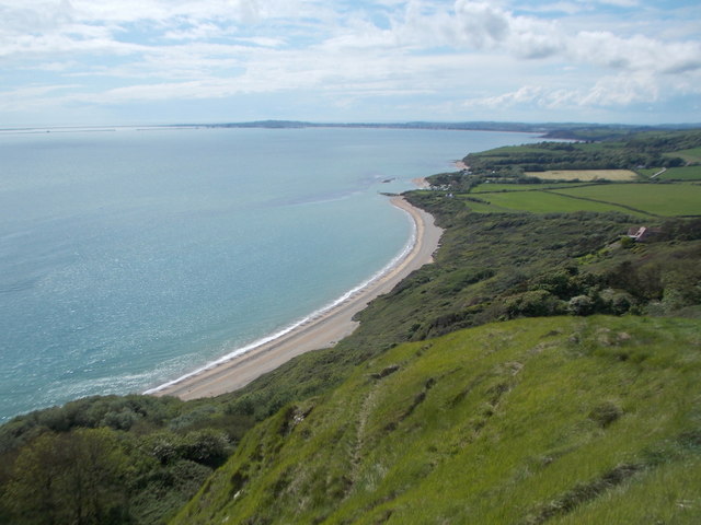
The village is nestled between the rolling hills of the South Dorset Downs and the English Channel, offering breathtaking views of the surrounding countryside and sea. Its tranquil atmosphere and charming thatched cottages make it a popular destination for tourists and nature enthusiasts alike.

Ringstead Village has a fascinating history that dates back to Roman times. It was an important trading post during the Roman occupation of Britain and remnants of Roman settlements can still be found in the area. The village also played a significant role during the Saxon and medieval periods, with evidence of ancient settlements and a medieval church that still stands today.

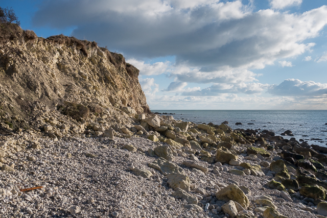
One of the main attractions in Ringstead Village is the Ringstead Bay, a beautiful pebble beach that stretches for miles along the coastline. The beach is a haven for fossil hunters, with numerous fossils and ammonites being discovered regularly. The bay also offers excellent opportunities for swimming, boating, and fishing.

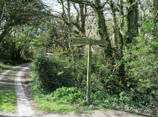
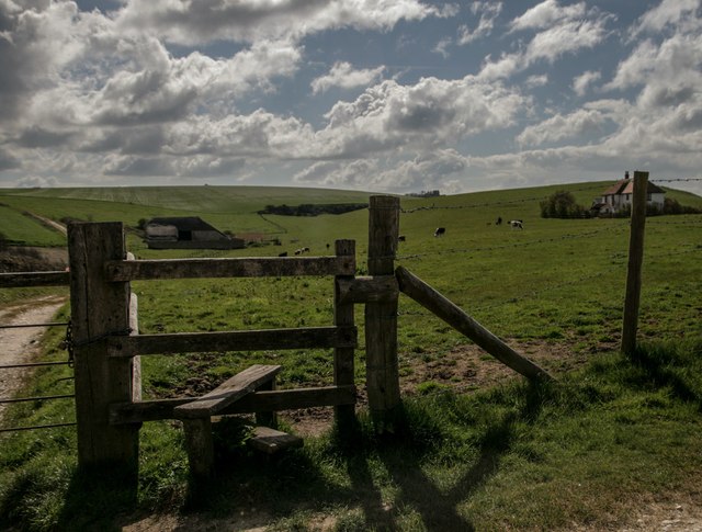
The village is surrounded by stunning countryside, with several walking and hiking trails that showcase the area's natural beauty. Visitors can explore the nearby Ringstead Downs, which is a designated Area of Outstanding Natural Beauty, or take a leisurely stroll along the South West Coast Path, which offers panoramic views of the coastline.

In conclusion, Ringstead Village in Dorset is a charming and historically significant destination that offers a unique blend of natural beauty and cultural heritage. It is a must-visit location for anyone seeking a tranquil escape and a glimpse into the region's rich history.

If you have any feedback on the listing, please let us know in the comments section below.

Ringstead Village Images

Images are sourced within 2km of 50.632/-2.36 or Grid Reference SY7481. Thanks to Geograph Open Source API. All images are credited.

The Smugglers Inn, Osmington Mills Several hundred years ago this pub was notorious for its connections with smuggling, then called The Crown.  The landlord of that time, Emmanuel Carless, worked closely with a famous smuggler Pierre Latour (known as French Peter) to land contraband from his fast boat L'Hirondelle.  Pierre was a gang leader who lived in Weymouth.  He managed to slip through the hands of the Revenue officers and eventually retired marrying Emmanuel's daughter, Arabella Carless.  The pub is situated off the beaten track and lies down in a dip above the beach.
The Smugglers Inn, Osmington Mills
Several hundred years ago this pub was notorious for its connections with smuggling, then called The Crown. The landlord of that time, Emmanuel Carless, worked closely with a famous smuggler Pierre Latour (known as French Peter) to land contraband from his fast boat L'Hirondelle. Pierre was a gang leader who lived in Weymouth. He managed to slip through the hands of the Revenue officers and eventually retired marrying Emmanuel's daughter, Arabella Carless. The pub is situated off the beaten track and lies down in a dip above the beach.
Cliff edge - Osmington Mills This is the view looking westwards from the carpark.  The Jurassic Coast has many areas of geological interest for example here there is a Corallian strata limestone barrier and some Kimmeridge Clay and other types of rock. There are also fossils which in the main are hard to knock out.
Cliff edge - Osmington Mills
This is the view looking westwards from the carpark. The Jurassic Coast has many areas of geological interest for example here there is a Corallian strata limestone barrier and some Kimmeridge Clay and other types of rock. There are also fossils which in the main are hard to knock out.
Coastline cruising near Osmington Mills This boat probably comes from Weymouth.  It was filled with sightseers, and fortunately the sea was calm despite a slight breeze!  A good way to view the Jurassic Coast on a fine day.
Coastline cruising near Osmington Mills
This boat probably comes from Weymouth. It was filled with sightseers, and fortunately the sea was calm despite a slight breeze! A good way to view the Jurassic Coast on a fine day.
Stile by old radar station bunker Also waymarker for coast path
Stile by old radar station bunker
Also waymarker for coast path
Coastline in Ringstead Bay
Signpost on South-west Coast Path
Stile and footpath past Brimstone Bottom Barn
Holworth: the chapel of St. Catherine’s-by-the-Sea Changes have been made to the chapel since I last photographed it in 2009 (see <a href="https://www.geograph.org.uk/photo/1416551">SY7681 : Holworth: the porch of St. Catherine’s</a>). Up to then, the entrance had been at the western end, making it difficult to photograph it in full without appearing to be from the back or side. 

Now, the entrance has been put into this northern side, making this a much more satisfactory picture.

Also, a little bell turret has been added, meaning that the bell is no longer contained in a separate frame in the churchyard (see <a href="https://www.geograph.org.uk/photo/1416570">SY7681 : Holworth: the bell of St. Catherine’s</a>).
Holworth: the chapel of St. Catherine’s-by-the-Sea
Changes have been made to the chapel since I last photographed it in 2009 (see SY7681 : Holworth: the porch of St. Catherine’s). Up to then, the entrance had been at the western end, making it difficult to photograph it in full without appearing to be from the back or side. Now, the entrance has been put into this northern side, making this a much more satisfactory picture. Also, a little bell turret has been added, meaning that the bell is no longer contained in a separate frame in the churchyard (see SY7681 : Holworth: the bell of St. Catherine’s).
Holworth: buttercups in St. Catherine’s churchyard A yellow carpet covers the churchyard on the seaward side of the <a href="https://www.geograph.org.uk/photo/4963768">SY7681 : Holworth: the chapel of St. Catherine’s-by-the-Sea</a>.
Holworth: buttercups in St. Catherine’s churchyard
A yellow carpet covers the churchyard on the seaward side of the SY7681 : Holworth: the chapel of St. Catherine’s-by-the-Sea.
Holworth: the slopes of White Nothe drop down to Ringstead Bay Looking west from the cliff top at White Nothe - in this direction the cliffs are more like a grassy slope, although there are sheer, white chalk cliff faces behind us.

The land drops down to the shingle beach of Ringstead Bay, while the coastline continues in the background to Weymouth (the town centre is just right of centre) and Portland Harbour (the harbour walls can be seen far-left).
Holworth: the slopes of White Nothe drop down to Ringstead Bay
Looking west from the cliff top at White Nothe - in this direction the cliffs are more like a grassy slope, although there are sheer, white chalk cliff faces behind us. The land drops down to the shingle beach of Ringstead Bay, while the coastline continues in the background to Weymouth (the town centre is just right of centre) and Portland Harbour (the harbour walls can be seen far-left).
Ringstead: the coast path crosses The Glen A small stream, going through a steep-sided valley lined narrowly with trees necessitates two steep flights of steps on the coast path. After a day of heavy rain yesterday, muddy puddles adorn almost every step. 

A further path, running alongside the stream, comes from the beach a few yards to our right and continues inland.
Ringstead: the coast path crosses The Glen
A small stream, going through a steep-sided valley lined narrowly with trees necessitates two steep flights of steps on the coast path. After a day of heavy rain yesterday, muddy puddles adorn almost every step. A further path, running alongside the stream, comes from the beach a few yards to our right and continues inland.
Ringstead: the stream in The Glen enters a tube The final few yards of this stream's journey takes a man-made course through a pipe as it reaches Ringstead Bay.
Ringstead: the stream in The Glen enters a tube
The final few yards of this stream's journey takes a man-made course through a pipe as it reaches Ringstead Bay.
Ringstead: footbridge on the Osmington Mills path At the western end of the little village, the path continues by way of this bridge over a tiny stream, as it heads for Osmington Mills and Weymouth.
Ringstead: footbridge on the Osmington Mills path
At the western end of the little village, the path continues by way of this bridge over a tiny stream, as it heads for Osmington Mills and Weymouth.
Ringstead: ford on a track where footpaths meet This is the meeting place of three public footpaths, two leading along the gravel track (foreground, left and right) and the third ahead of us, coming down through a field from Upton Fort. Access to/from the latter requires the crossing of a shallow ford, and a line of smallish stones has been considerately laid out to assist.
Ringstead: ford on a track where footpaths meet
This is the meeting place of three public footpaths, two leading along the gravel track (foreground, left and right) and the third ahead of us, coming down through a field from Upton Fort. Access to/from the latter requires the crossing of a shallow ford, and a line of smallish stones has been considerately laid out to assist.
Osmington Mills: looking back at a thatched cottage The inland footpath to Ringstead runs diagonally through this field, all yellow with buttercups. We look back just as a thatched cottage starts disappearing from view thanks to the gradient.
Osmington Mills: looking back at a thatched cottage
The inland footpath to Ringstead runs diagonally through this field, all yellow with buttercups. We look back just as a thatched cottage starts disappearing from view thanks to the gradient.
Osmington Mills: a waterfall and the cliffs of Bran Point A stream issues into Ringstead Bay here at Osmington Mills and its final manoeuvre before doing so is to cascade over the little ledge, 3 feet or so in height, onto the large stones of the beach.

In the background, we see the green slopes of Bran Point - the actual point of the headland is in the next square east, beyond what is visible here.
Osmington Mills: a waterfall and the cliffs of Bran Point
A stream issues into Ringstead Bay here at Osmington Mills and its final manoeuvre before doing so is to cascade over the little ledge, 3 feet or so in height, onto the large stones of the beach. In the background, we see the green slopes of Bran Point - the actual point of the headland is in the next square east, beyond what is visible here.
Osmington Mills: canoeists negotiate Hannah’s Ledge These canoeists set off from Ringstead, a mile or so east, and kept more or less exact time with me as I walked along the cliff-top path to Osmington Mills. Here, we look down on them as they pass Hannah's Ledge, a stretch of tidal rocks projecting from the beach.
Osmington Mills: canoeists negotiate Hannah’s Ledge
These canoeists set off from Ringstead, a mile or so east, and kept more or less exact time with me as I walked along the cliff-top path to Osmington Mills. Here, we look down on them as they pass Hannah's Ledge, a stretch of tidal rocks projecting from the beach.
Osmington Mills: the coast path from Bran Point The cliff-top path starts to descend into the village of Osmington Mills and is separated from the cliff face by a hedge shaped distinctively by the prevailing southwesterly winds.
Osmington Mills: the coast path from Bran Point
The cliff-top path starts to descend into the village of Osmington Mills and is separated from the cliff face by a hedge shaped distinctively by the prevailing southwesterly winds.
Show me another place!

Ringstead Village is located at Grid Ref: SY7481 (Lat: 50.632, Lng: -2.36)

Unitary Authority: Dorset

Police Authority: Dorset

What 3 Words

///feasting.premiums.harmonica. Near Overcombe, Dorset

Related Wikis

Perry Ledge

Perry Ledge is a reef west of Ringstead in Dorset, England.The ledge consists of limestone dating from the Jurassic period and is exposed at low tide....

West Ringstead

West Ringstead is a deserted medieval village located on the coast in Dorset, southern England. The village lies on the Jurassic Coast and is located west...

Ringstead, Dorset

Ringstead is a small seaside village located on the coast in Dorset, southern England. The area lies on the Jurassic Coast and is known for its natural...

Bran Point

Bran Point is a small headland on the Dorset coast in southern England, about halfway between the small villages of Ringstead to the east and Osmington...

Nearby Amenities

Located within 500m of 50.632,-2.36
Source: PGS
Lat/Long: 50.6315134/-2.3665433
Source: PGS
Lat/Long: 50.6311523/-2.3655391
Source: PGS
Lat/Long: 50.6310935/-2.364308
Source: PGS
Lat/Long: 50.631232/-2.3632576
Source: PGS
Lat/Long: 50.6311952/-2.3619406
Source: PGS
Lat/Long: 50.6313177/-2.3614487
Source: PGS
Lat/Long: 50.6315243/-2.3601741
Source: PGS
Lat/Long: 50.6315165/-2.3577784
Source: PGS
Lat/Long: 50.631218/-2.3565124
Source: PGS
Lat/Long: 50.6309941/-2.3554502
Source: PGS
Lat/Long: 50.6309026/-2.3548419
Source: PGS
Lat/Long: 50.6309822/-2.3538232
Ringstead
Place: hamlet
Wikidata: Q102231623
Lat/Long: 50.631884/-2.3530022
Cafe
Ringstead Bay Kiosk
Check Date: 2023-04-08
Lat/Long: 50.6324017/-2.3530372
Barrier: stile
Lat/Long: 50.6319255/-2.3570799
Post Box
Collection Times: Mo-Fr 09:00; Sa 07:00
Operator: Royal Mail
Post Box Type: wall
Ref: DT2 155D
Ref GB Uprn: 10015310183
Royal Cypher: EIIR
Royal Cypher Wikidata: Q33102113
Source: survey
Survey Date: 2022-12-03
Lat/Long: 50.6319771/-2.3534574
Parking Space
Lat/Long: 50.6325179/-2.3537822
Toilets
Access: yes
Check Date: 2023-04-08
Fee: no
Toilets Handwashing: yes
Toilets Position: outside
Lat/Long: 50.6323456/-2.3530631
The data included in this document is from www.openstreetmap.org. The data is made available under ODbL.

Have you been to Ringstead Village?

Leave your review of Ringstead Village below (or comments, questions and feedback).