Blackscrath

Island in Aberdeenshire

Scotland

Blackscrath

Pillbox at Cruden Beach
Pillbox at Cruden Beach Credit: Ralph Greig

Blackscrath, located in Aberdeenshire, is a small island situated off the northeast coast of Scotland. It is known for its stunning natural beauty and rich history, making it an attractive destination for both locals and tourists alike.

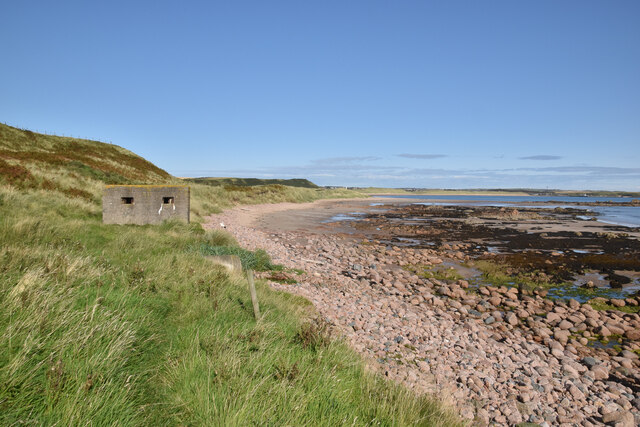
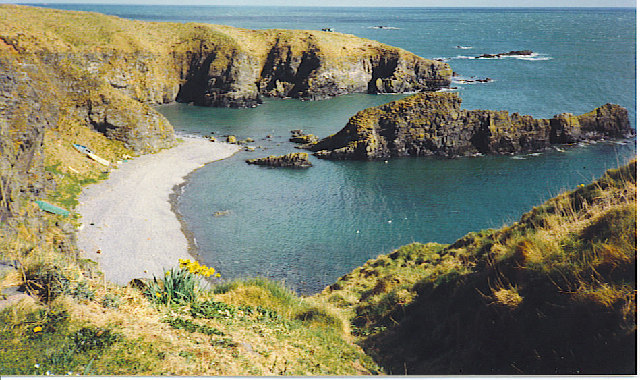
Covered in lush green vegetation, Blackscrath offers breathtaking views of the surrounding waters and rugged coastline. The island is home to a variety of wildlife, including seabirds, seals, and occasionally dolphins, making it a haven for nature enthusiasts. Its pristine beaches and secluded coves provide visitors with opportunities for peaceful walks and relaxation.

Despite its small size, Blackscrath has a long and fascinating history. Evidence of human habitation dates back thousands of years, with the remains of ancient settlements and burial sites scattered across the island. It was also a significant site during the Viking era, serving as a trading post and stronghold for these seafaring people.

Today, Blackscrath maintains a tranquil and remote atmosphere, with few permanent residents. The island's main industry is fishing, with local fishermen taking advantage of the abundant marine life in the surrounding waters. Additionally, tourism plays a vital role in the economy, with visitors drawn to the island's natural beauty and historical attractions.

Access to Blackscrath is limited, with regular ferry services connecting the island to the mainland. This isolation contributes to the island's charm, offering visitors a peaceful retreat away from the hustle and bustle of modern life.

In conclusion, Blackscrath is a picturesque island located in Aberdeenshire, Scotland. Its stunning natural landscapes, rich history, and tranquility make it an idyllic destination for those seeking a slice of Scottish island life.

If you have any feedback on the listing, please let us know in the comments section below.

Blackscrath Images

Images are sourced within 2km of 57.386506/-1.8683444 or Grid Reference NK0832. Thanks to Geograph Open Source API. All images are credited.

Pillbox at Cruden Beach
Whinnyfold Former fishing village perched on a clifftop above a small bay.
Whinnyfold
Former fishing village perched on a clifftop above a small bay.
Bay at Whinnyfold Not much shelter, but this was the beach used by the fisherman who used to live in the village.
Bay at Whinnyfold
Not much shelter, but this was the beach used by the fisherman who used to live in the village.
Anti Tank Blocks on Cruden Bay Beach WW2 defences on the beach at Cruden Bay have been utilised to stabilise the sand dunes at the mouth of this burn at the southern end of the golf links
Anti Tank Blocks on Cruden Bay Beach
WW2 defences on the beach at Cruden Bay have been utilised to stabilise the sand dunes at the mouth of this burn at the southern end of the golf links
Cruden Bay beach
Cruden Bay beach
The bay at  Whinnyfold Whinnyfold (pron. Finnyfa' by the locals) is a small Heugh-head hamlet, a former fishing settlement. Today a few small boats are still hauled up off the beach.
The bay at Whinnyfold
Whinnyfold (pron. Finnyfa' by the locals) is a small Heugh-head hamlet, a former fishing settlement. Today a few small boats are still hauled up off the beach.
Berry's Loup
Berry's Loup
Cruden Bay Beach
Cruden Bay Beach
Postbox at Whinnyfold Looking in the direction of Cruden Bay.
Postbox at Whinnyfold
Looking in the direction of Cruden Bay.
Whinnyfold small hamlet perched above high cliffs.
Whinnyfold
small hamlet perched above high cliffs.
Oil Pipeline Booster Station The pipeline bringing oil from the Forties Field and other integrated locations makes its landfall just south of Cruden Bay... (Cruden Bay / Crude Oil - very apt) Pumping Station to assist the black gold's onward route to Grangemouth Refinery.
Oil Pipeline Booster Station
The pipeline bringing oil from the Forties Field and other integrated locations makes its landfall just south of Cruden Bay... (Cruden Bay / Crude Oil - very apt) Pumping Station to assist the black gold's onward route to Grangemouth Refinery.
sheep grazing, Sandend Farm near Whinnyfold. Location of this snap gives a better than usual perspective of the 'Bay' aspect of Cruden Bay. Brooding ruin of Slains Castle to the right
sheep grazing, Sandend Farm
near Whinnyfold. Location of this snap gives a better than usual perspective of the 'Bay' aspect of Cruden Bay. Brooding ruin of Slains Castle to the right
War time pillbox protecting the beach at Cruden Bay
Rocks at the southern end of Cruden Bay Beach
WW2 pillbox at the southern end of Cruden Bay beach Cruden Bay beach would have been a good landing ground for the Germans in 1942. It was heavily defended with pillboxes, gun batteries and anti-tank blocks.
WW2 pillbox at the southern end of Cruden Bay beach
Cruden Bay beach would have been a good landing ground for the Germans in 1942. It was heavily defended with pillboxes, gun batteries and anti-tank blocks.
WW2 pillbox at the southern end of Cruden Bay beach
Hay Farm, near Cruden Bay spring barley crop just starting to come through
Hay Farm, near Cruden Bay
spring barley crop just starting to come through
North Sea Oil landfall This is a pumping booster station on the pipeline carrying oil from the North Sea.
North Sea Oil landfall
This is a pumping booster station on the pipeline carrying oil from the North Sea.
Show me another place!

Blackscrath is located at Grid Ref: NK0832 (Lat: 57.386506, Lng: -1.8683444)

Unitary Authority: Aberdeenshire

Police Authority: North East

What 3 Words

///cools.welcome.thrilled. Near Port Erroll, Aberdeenshire

Related Wikis

Whinnyfold

Whinnyfold or Whinneyfold is a small coastal village at the southern end of the Bay of Cruden in Aberdeenshire, Scotland. Whinnyfold (locally pronounced...

Cruden Bay Hotel

Cruden Bay Hotel was a hotel in Cruden Bay, Aberdeenshire, Scotland. Following the success of the Palace Hotel in Aberdeen, it was built between 1897 and...

Water of Cruden

The Water of Cruden is a short broadly east-flowing river in Buchan in northeast Scotland. Its headwaters streams rise in the countryside north of Ellon...

Cruden Bay Hotel Tramway

The Cruden Bay Hotel Tramway operated an electric tramway service between the Cruden Bay Hotel and Cruden Bay railway station between 1899 and 1940....

Nearby Amenities

Located within 500m of 57.386506,-1.8683444
Source: OS7
Lat/Long: 57.388568/-1.8625556
Source: Old Landsat image trace
Lat/Long: 57.3892503/-1.8629838
Source: Old Landsat image trace
Lat/Long: 57.3890282/-1.8639591
Source: Old Landsat image trace
Lat/Long: 57.3889432/-1.8652745
Source: Old Landsat image trace
Lat/Long: 57.3881696/-1.8665827
Source: OS7
Lat/Long: 57.3870534/-1.8677242
Source: OS7
Lat/Long: 57.387028/-1.8681233
Source: OS7
Lat/Long: 57.386263/-1.8691972
Source: OS7
Lat/Long: 57.3854333/-1.8680085
Source: OS7
Lat/Long: 57.3848605/-1.8687871
Source: OS7
Lat/Long: 57.3845958/-1.8697074
Source: OS7
Lat/Long: 57.3846678/-1.8705887
Source: Old Landsat image trace
Lat/Long: 57.3850517/-1.8715292
Source: Old Landsat image trace
Lat/Long: 57.3845594/-1.8723931
Source: Old Landsat image trace
Lat/Long: 57.3839761/-1.8722726
Source: OS7
Lat/Long: 57.3833791/-1.8718024
Source: OS7
Lat/Long: 57.3834028/-1.8724089
Source: OS7
Lat/Long: 57.3833109/-1.8725189
Whinnyfold
Alt Name En: Whinneyfold;Whinnyfauld
Alt Name Sco: Finnyfa;Finnyfaa;Finnyfaul
Is In: Aberdeenshire
Name Sco: Finnyfaal
Place: hamlet
Wikidata: Q7993680
Wikipedia: en:Whinnyfold
Lat/Long: 57.3893314/-1.8668315
Power: pole
Lat/Long: 57.3897383/-1.8670175
Power: pole
Lat/Long: 57.3890881/-1.8677414
Power: pole
Lat/Long: 57.3889957/-1.8688443
Power: pole
Lat/Long: 57.3888759/-1.8701905
Power: pole
Lat/Long: 57.3887561/-1.8715177
Power: pole
Lat/Long: 57.3886363/-1.8728576
Power: pole
Lat/Long: 57.3885336/-1.874062
Power: pole
Lat/Long: 57.3884059/-1.8756094
Power: pole
Lat/Long: 57.3896219/-1.8660247
Power: pole
Lat/Long: 57.3897389/-1.8665867
Power: pole
Lat/Long: 57.3900435/-1.8675869
Power: pole
Lat/Long: 57.3903001/-1.8680219
Power: pole
Lat/Long: 57.3905015/-1.8684855
Power: pole
Lat/Long: 57.3907735/-1.869094
The data included in this document is from www.openstreetmap.org. The data is made available under ODbL.

Have you been to Blackscrath?

Leave your review of Blackscrath below (or comments, questions and feedback).