Blind Man

Island in Aberdeenshire

Scotland

Blind Man

Old Slains Castle
Old Slains Castle Credit: Alan Reid

Blind Man is a small island located off the coast of Aberdeenshire, Scotland. With an area of approximately 0.5 square kilometers, it is one of the many islands that dot the Aberdeenshire coastline. Despite its small size, Blind Man Island holds great historical and cultural significance.

The island's name is believed to have originated from a local legend that tells the story of a blind man who was stranded on the island during a storm and miraculously found his way back to safety. This tale has been passed down through generations, contributing to the island's unique identity.

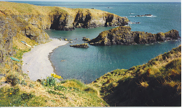
Blind Man Island is primarily known for its stunning natural beauty. The rugged coastline is adorned with picturesque cliffs and rocky outcrops, providing breathtaking views of the North Sea. The island is also home to a diverse range of flora and fauna, making it a haven for wildlife enthusiasts and nature lovers.

Although uninhabited today, Blind Man Island was once home to a small fishing community. Remnants of old cottages and fishing equipment can still be found, serving as a reminder of the island's past. Visitors can explore these historical sites and immerse themselves in the island's rich heritage.

Access to Blind Man Island is limited, as it can only be reached by boat. However, its remote location and tranquil atmosphere make it a popular destination for those seeking solitude and a break from the bustling city life.

In conclusion, Blind Man Island in Aberdeenshire offers a unique blend of history, natural beauty, and tranquility. Its rich folklore, stunning landscapes, and secluded location make it a hidden gem awaiting discovery.

If you have any feedback on the listing, please let us know in the comments section below.

Blind Man Images

Images are sourced within 2km of 57.36008/-1.9105088 or Grid Reference NK0529. Thanks to Geograph Open Source API. All images are credited.

Old Slains Castle
Old Slains Castle
Broad Haven Looking north-east up the coastline to Broad Haven.
Broad Haven
Looking north-east up the coastline to Broad Haven.
Mains of Slains Mains of Slains viewed from the road to the north.
Mains of Slains
Mains of Slains viewed from the road to the north.
Wetland near Blackhill Former loch adjacent to the A975 near Blackhill.
Wetland near Blackhill
Former loch adjacent to the A975 near Blackhill.
Barley near the A975 Billowing barley field next to the A975 near Slains School.
Barley near the A975
Billowing barley field next to the A975 near Slains School.
A species from the deep past The common horse-tail, Equisetum arvense, is an ancient species of plant whose ancestors were browsed by dinosaurs. Modern horsetails are only a few centimetres high but their ancestors included tree-like species up to 200 feet in height living in the Carboniferous forests. They all evolved long before the flowering plants came along and they produce spores rather than seeds. 

Horsetails grow in moist, rich soils in all parts of the world except Australasia. Some, including ours, produce two kinds of shoots. The first shoots to emerge in the spring are the reproductive squad and are topped with cone-like clusters of spore capsules. These are the ones in the photograph. In a couple of weeks time they will be replaced with green shoots whose role in life will be photosynthesis, growth and replenishing the energy stores.
A species from the deep past
The common horse-tail, Equisetum arvense, is an ancient species of plant whose ancestors were browsed by dinosaurs. Modern horsetails are only a few centimetres high but their ancestors included tree-like species up to 200 feet in height living in the Carboniferous forests. They all evolved long before the flowering plants came along and they produce spores rather than seeds. Horsetails grow in moist, rich soils in all parts of the world except Australasia. Some, including ours, produce two kinds of shoots. The first shoots to emerge in the spring are the reproductive squad and are topped with cone-like clusters of spore capsules. These are the ones in the photograph. In a couple of weeks time they will be replaced with green shoots whose role in life will be photosynthesis, growth and replenishing the energy stores.
Particoloured Tup This smart and rather unusual fellow was one of half a dozen tups roaming the cliffs. The others were mostly uniform in colour.
Particoloured Tup
This smart and rather unusual fellow was one of half a dozen tups roaming the cliffs. The others were mostly uniform in colour.
Fold Hinge Although it looks like a continuation, the section of the hinge in the black rocks is actually separated from the part on the left by a narrow sea inlet. This can be seen in <a href="https://www.geograph.org.uk/photo/1945678">NK0630 : Still More of the Recumbent Fold</a>.
Fold Hinge
Although it looks like a continuation, the section of the hinge in the black rocks is actually separated from the part on the left by a narrow sea inlet. This can be seen in NK0630 : Still More of the Recumbent Fold.
Folding the other way The most prominent hinges here close to the left, but this shows the other part of the structure, closing to the right, the whole forming an S-shaped fold.
Folding the other way
The most prominent hinges here close to the left, but this shows the other part of the structure, closing to the right, the whole forming an S-shaped fold.
Field Mushroom? I can't be certain what this is. There were several in the grass by the path. Any help with identification will be welcome.
Field Mushroom?
I can't be certain what this is. There were several in the grass by the path. Any help with identification will be welcome.
Mushrooms or Toadstools? Someone or something had uprooted the large fungus, so I moved it closer to the ones still in situ. I do not know what they are; I can only say that the large one did not smell at all appetising. Any help with identification welcome.
Mushrooms or Toadstools?
Someone or something had uprooted the large fungus, so I moved it closer to the ones still in situ. I do not know what they are; I can only say that the large one did not smell at all appetising. Any help with identification welcome.
South Newclochtow A clump of thistles clusters round the fence near South Newclochtow. There is barley on the field to the right, and grass with clover in the field on the left.
South Newclochtow
A clump of thistles clusters round the fence near South Newclochtow. There is barley on the field to the right, and grass with clover in the field on the left.
Slains Kirk, Collieston
Former fishermans' cottages, Collieston
Road out of the village
The Old Manse, Collieston
The big rock behind the car park, Collieston
Rocky coast, Collieston Unforgiving rocks stretch for several kilometres either side of the narrow entrance to Collieston harbour.
Rocky coast, Collieston
Unforgiving rocks stretch for several kilometres either side of the narrow entrance to Collieston harbour.
Show me another place!

Blind Man is located at Grid Ref: NK0529 (Lat: 57.36008, Lng: -1.9105088)

Unitary Authority: Aberdeenshire

Police Authority: North East

What 3 Words

///prefect.superhero.passports. Near Port Erroll, Aberdeenshire

Related Wikis

Old Slains Castle

Slains Castle (otherwise known as Old Slains Castle) is a ruined castle near Collieston in Aberdeenshire, Scotland. It is not to be confused with New Slains...

Collieston

Collieston is a small former fishing village on the North Sea coast in Aberdeenshire, Scotland. The village lies just north of the Sands of Forvie Special...

Meikle Loch

Meikle Loch is an inland loch some miles north of Collieston, Aberdeenshire, Scotland. It is designated as part of the Ythan Estuary complex, along with...

Cotehill Loch

Cotehill Loch is a freshwater loch located in Scotland in the Aberdeenshire area, approximately one mile (1.5 km) northwest of the coastal town of Collieston...

Ythan Estuary

The Ythan Estuary (Scottish Gaelic: Inbhir Eithein) is the tidal component of the Ythan River, emptying into the North Sea 19 kilometres (12 mi) north...

Whinnyfold

Whinnyfold or Whinneyfold is a small coastal village at the southern end of the Bay of Cruden in Aberdeenshire, Scotland. Whinnyfold (locally pronounced...

Hackley Head

Hackley Head (otherwise Forvie Ness) is a headland in Aberdeenshire, northeast Scotland. Hackley Head is located to the south of Hackley Bay and to the...

Forvie

Forvie was a village in what is now the Forvie National Nature Reserve, located at the modern location of Rockend some fourteen miles north of Aberdeen...

Nearby Amenities

Located within 500m of 57.36008,-1.9105088
Source: Old Landsat image trace
Lat/Long: 57.3642983/-1.9108434
Source: Old Landsat image trace
Lat/Long: 57.3636144/-1.9113283
Source: Old Landsat image trace
Lat/Long: 57.3632672/-1.9131533
Source: Old Landsat image trace
Lat/Long: 57.3632308/-1.9141607
Source: Old Landsat image trace
Lat/Long: 57.3628344/-1.9148356
Source: Old Landsat image trace
Lat/Long: 57.3621991/-1.9150523
Source: Old Landsat image trace
Lat/Long: 57.3616928/-1.9146982
Source: Old Landsat image trace
Lat/Long: 57.3615342/-1.9137455
Source: Old Landsat image trace
Lat/Long: 57.360686/-1.9119017
Source: Old Landsat image trace
Lat/Long: 57.3606114/-1.911735
Source: Old Landsat image trace
Lat/Long: 57.3599074/-1.9126576
Source: Old Landsat image trace
Lat/Long: 57.3599497/-1.9131603
Source: Old Landsat image trace
Lat/Long: 57.3600158/-1.9141478
Source: Old Landsat image trace
Lat/Long: 57.3600074/-1.9156446
Source: Old Landsat image trace
Lat/Long: 57.3596052/-1.9160317
Source: Old Landsat image trace
Lat/Long: 57.359051/-1.9164129
Source: Old Landsat image trace
Lat/Long: 57.3587912/-1.9165511
Source: Old Landsat image trace
Lat/Long: 57.3589551/-1.9171279
Power: pole
Lat/Long: 57.3612989/-1.9181836
Power: pole
Lat/Long: 57.3612077/-1.9170239
Power: pole
Lat/Long: 57.3610921/-1.9155736
Power: pole
Lat/Long: 57.3610446/-1.9148378
The data included in this document is from www.openstreetmap.org. The data is made available under ODbL.

Have you been to Blind Man?

Leave your review of Blind Man below (or comments, questions and feedback).