Smugglers' Hole

Coastal Feature, Headland, Point in Yorkshire

England

Smugglers' Hole

Flamborough Head, North Landing The Rails used to launch the lifeboat from its hut high above sea level can be seen.
Flamborough Head, North Landing Credit: Paul Allison

Smugglers' Hole is a notable coastal feature located in Yorkshire, England. Situated along the rugged and picturesque coastline, it is a prominent headland and point that has gained historical significance due to its association with smuggling activities during the 18th and 19th centuries.

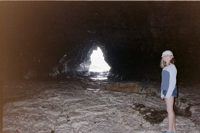
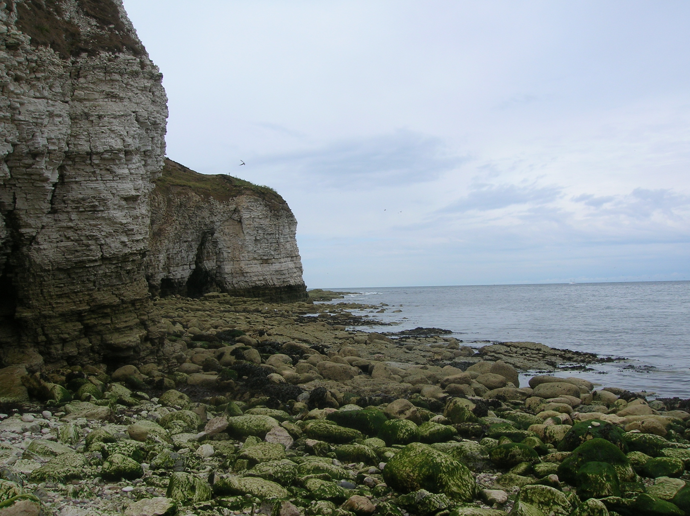
This captivating location is characterized by its towering cliffs and rocky outcrops, creating a dramatic backdrop against the crashing waves of the North Sea. Smugglers' Hole is particularly renowned for its intricate network of caves and hidden passages that were utilized by smugglers to transport contraband, such as alcohol, tobacco, and other goods, evading the authorities.

The strategic positioning of Smugglers' Hole made it an ideal location for these illicit activities. Its secluded nature, coupled with the treacherous and unpredictable nature of the coastline, provided smugglers with a perfect hideout and escape route. The labyrinthine caves and tunnels served as secret storage spaces and hideaways, ensuring the success of their operations.

Today, Smugglers' Hole stands as a popular tourist attraction, drawing visitors from far and wide to explore its historical past and breathtaking natural beauty. The caves can still be ventured into, although caution is advised due to the unstable nature of the rocks. Many visitors are intrigued by the tales of smugglers and the daring exploits that took place within these very caverns.

Overall, Smugglers' Hole in Yorkshire stands as a captivating coastal feature, offering a glimpse into the mysterious and thrilling world of smuggling, while also providing a stunning vista of the Yorkshire coastline.

If you have any feedback on the listing, please let us know in the comments section below.

Smugglers' Hole Images

Images are sourced within 2km of 54.131889/-0.11197558 or Grid Reference TA2372. Thanks to Geograph Open Source API. All images are credited.

Flamborough Head, North Landing The Rails used to launch the lifeboat from its hut high above sea level can be seen.
Flamborough Head, North Landing
The Rails used to launch the lifeboat from its hut high above sea level can be seen.
North Landing Looking South towards North landing
North Landing
Looking South towards North landing
North Landing North Landing at low tide in summer 2005
North Landing
North Landing at low tide in summer 2005
Cliffs At Thornwick Bay, Flamborough From holiday In Yorkshire
Cliffs At Thornwick Bay, Flamborough
From holiday In Yorkshire
Flamborough Cliffs Taken from Breil Nook towards Breil Head. Information on Flamborough can be found at these websites.
<span class="nowrap"><a title="http://en.wikipedia.org/wiki/Flamborough_Head" rel="nofollow ugc noopener" href="http://en.wikipedia.org/wiki/Flamborough_Head">Link</a><img style="margin-left:2px;" alt="External link" title="External link - shift click to open in new window" src="https://s1.geograph.org.uk/img/external.png" width="10" height="10"/></span>
<span class="nowrap"><a title="http://www.flamboroughuk.net/" rel="nofollow ugc noopener" href="http://www.flamboroughuk.net/">Link</a><img style="margin-left:2px;" alt="External link" title="External link - shift click to open in new window" src="https://s1.geograph.org.uk/img/external.png" width="10" height="10"/></span>
Flamborough Cliffs
Taken from Breil Nook towards Breil Head. Information on Flamborough can be found at these websites. LinkExternal link LinkExternal link
Smugglers Dream An inlet on the Flamborough Head Coast.
Smugglers Dream
An inlet on the Flamborough Head Coast.
Carter Lane, Flamborough A typical cliff view at Carter Lane, Flamborough.
Carter Lane, Flamborough
A typical cliff view at Carter Lane, Flamborough.
Underwater Rock Formations The North Sea from the tip of the cliffs at the North Landing, Flamborough. The underwater formations are called wave-cut platforms. They mark the former edge of the cliff line before erosion.
Underwater Rock Formations
The North Sea from the tip of the cliffs at the North Landing, Flamborough. The underwater formations are called wave-cut platforms. They mark the former edge of the cliff line before erosion.
North Landing The North Landing, Flamborough Head. Excellent for exploring caves when the tide is out. You can just make out Bempton Cliffs in the far top left of the photo.
North Landing
The North Landing, Flamborough Head. Excellent for exploring caves when the tide is out. You can just make out Bempton Cliffs in the far top left of the photo.
Flamborough Coastline The end of the cliffs at North Landing and Bempton Cliffs in view in the distance. Boat trips from the North Landing explore the caves around this headland and sometimes actually go into the caves themselves, swell permitting!
Flamborough Coastline
The end of the cliffs at North Landing and Bempton Cliffs in view in the distance. Boat trips from the North Landing explore the caves around this headland and sometimes actually go into the caves themselves, swell permitting!
Chalk Cliffs Flamborough's North Landing.
Chalk Cliffs
Flamborough's North Landing.
North Landing Another view of North Landing with the now disused Lifeboat Station in view bottom right.
North Landing
Another view of North Landing with the now disused Lifeboat Station in view bottom right.
Sea Cliffs The Sea Cliffs at the North Landing, Flamborough. The hut is used by the local fisherman to store all their belongings etc.
Sea Cliffs
The Sea Cliffs at the North Landing, Flamborough. The hut is used by the local fisherman to store all their belongings etc.
North landing, Flamborough Head. Chalk cliffs, sea caves, fishing boats, old lifeboat station.
North landing, Flamborough Head.
Chalk cliffs, sea caves, fishing boats, old lifeboat station.
Cliff top, Flamborough Head. The old iron rings set into concrete were formelly used to attach the ropes used by men climbing down the cliffs to harvest sea bird eggs.
Cliff top, Flamborough Head.
The old iron rings set into concrete were formelly used to attach the ropes used by men climbing down the cliffs to harvest sea bird eggs.
Chalk, North Landing Bay A clean break through the chalk reveals an almost pure white!
Chalk, North Landing Bay
A clean break through the chalk reveals an almost pure white!
Cave Interior A large cave entered on the east side of North Landing Bay in square TA2372.
It continues round to the north where it leads 
to a second entrance, pictured here.
Cave Interior
A large cave entered on the east side of North Landing Bay in square TA2372. It continues round to the north where it leads to a second entrance, pictured here.
The King 'The King' is the local name for this chalk stump.
Boat trips taken from North Landing Bay (behind the cliffs in the far distance)
allow such close up views of the coast from the sea!
The King
'The King' is the local name for this chalk stump. Boat trips taken from North Landing Bay (behind the cliffs in the far distance) allow such close up views of the coast from the sea!
Show me another place!

Smugglers' Hole is located at Grid Ref: TA2372 (Lat: 54.131889, Lng: -0.11197558)

Division: East Riding

Unitary Authority: East Riding of Yorkshire

Police Authority: Humberside

What 3 Words

///engine.motorist.rarely. Near Flamborough, East Yorkshire

Related Wikis

Flamborough

Flamborough is a village and civil parish in the East Riding of Yorkshire, England. It is situated approximately 4 miles (6 km) north-east of Bridlington...

Coastal erosion in Yorkshire

Coastal erosion in Yorkshire has been a process that has been documented since Roman times. Rates of erosion on the Holderness coast are known to be the...

Flamborough Head

Flamborough Head () is a promontory, 8 miles (13 km) long on the Yorkshire coast of England, between the Filey and Bridlington bays of the North Sea. It...

Flamborough Lifeboat Station

Flamborough Lifeboat Station is a Royal National Lifeboat Institution (RNLI) lifeboat station located at Flamborough in the East Riding of Yorkshire, England...

Nearby Amenities

Located within 500m of 54.131889,-0.11197558
Source: PGS
Lat/Long: 54.131213/-0.1127212
Source: PGS
Lat/Long: 54.1312956/-0.1137356
Source: PGS
Lat/Long: 54.1328426/-0.1170798
Parking
Lat/Long: 54.1312912/-0.1162097
Cafe
Thornwick Bay Cafe
Source: survey
Lat/Long: 54.1316247/-0.1162484
Barrier: kissing_gate
Foot: yes
Source: survey
Lat/Long: 54.1295286/-0.118401
Source: PGS
Lat/Long: 54.1312862/-0.1140875
Barrier: stile
Foot: yes
Lat/Long: 54.13124/-0.1109295
Barrier: stile
Foot: yes
Lat/Long: 54.132075/-0.1105339
Mermaid Hole
Natural: cave_entrance
Lat/Long: 54.1306755/-0.1045998
Horse Hole
Access: yes
Description: A small cave down on the beach at North Landing - the ceilings are high and wide. It goes back in under the clifftops appx 20 yards.
Direction: 90
Fee: no
Natural: cave_entrance
Lat/Long: 54.1294733/-0.1062599
The data included in this document is from www.openstreetmap.org. The data is made available under ODbL.

Have you been to Smugglers' Hole?

Leave your review of Smugglers' Hole below (or comments, questions and feedback).