Selchie Geo

Coastal Feature, Headland, Point in Shetland

Scotland

Selchie Geo

Peat extraction, Virdi Field
Peat extraction, Virdi Field Credit: John Lucas

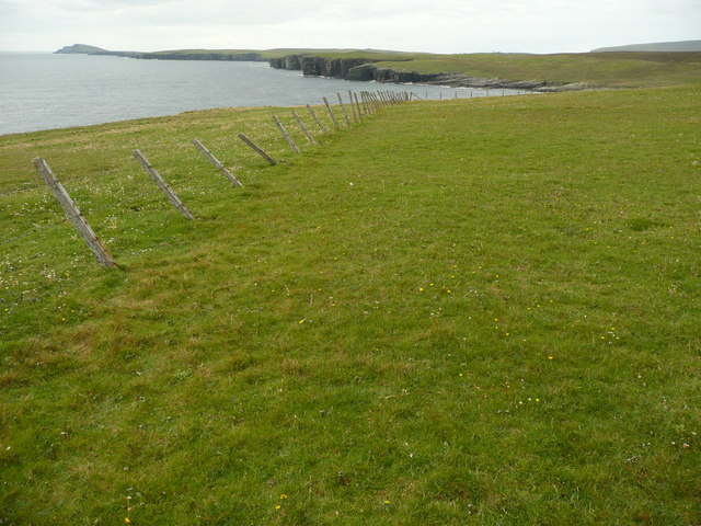
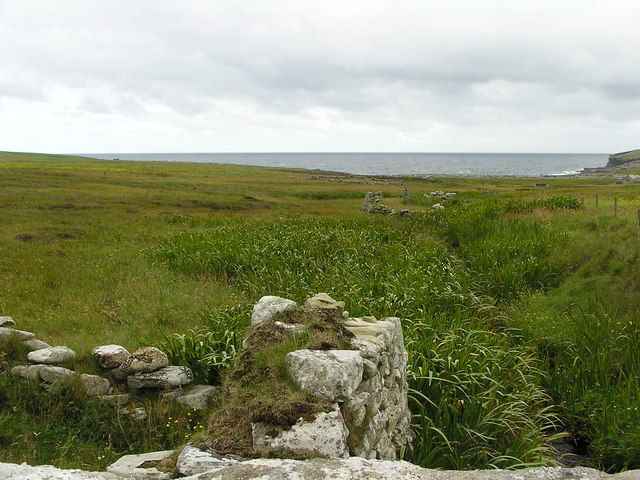
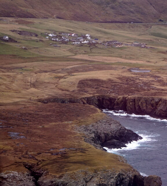
Selchie Geo is a prominent coastal feature located in Shetland, an archipelago in Scotland. It is a headland or point that juts out into the North Sea, offering breathtaking views of the surrounding landscape. The term "geo" is derived from the Norse word "gjá," which means a narrow inlet or cleft in the land formed by erosion.

Selchie Geo is known for its rugged and dramatic cliffs, which rise steeply from the sea. These cliffs are composed of layers of sedimentary rock, primarily sandstone and shale, which have been shaped over millions of years by the relentless action of waves and weathering. The resulting rock formations create a stunning display of colors and textures, ranging from deep reds and browns to pale yellows and grays.

The headland is also home to a diverse array of seabirds, including puffins, guillemots, and kittiwakes, which nest and roost in the cliffs. Their presence adds to the area's natural beauty and provides a unique opportunity for birdwatching enthusiasts.

Due to its exposed location, Selchie Geo can be subject to powerful waves and strong winds, making it a popular spot for surfers and windsurfers seeking challenging conditions. However, caution is advised when venturing too close to the cliff edges, as they can be unstable and pose a safety risk.

Overall, Selchie Geo is a remarkable coastal feature that showcases the raw power of nature and offers visitors a chance to experience the untamed beauty of Shetland's coastline.

If you have any feedback on the listing, please let us know in the comments section below.

Selchie Geo Images

Images are sourced within 2km of 59.951917/-1.2628138 or Grid Reference HU4118. Thanks to Geograph Open Source API. All images are credited.

Peat extraction, Virdi Field
A970 near Southpunds The A970 runs for 71 miles across most of the length of the "Mainland" in the Shetland Islands. It is a good-quality single-carriageway road for most of its route. Travelling from south to north, the road begins at Grutness near Sumburgh Airport and winds around the many hills and inlets passing close to a number of small villages without going through any large ones before Lerwick. After looping around Lerwick, a short spur runs to Scalloway whilst the main route continues northwards towards Brae where it crosses the narrow isthmus of Mavis Grind. At Sandy Lochs the road splits and a four-mile spur goes through Urafirth to Hillswick. The main route continuing to the right towards its northern terminus at Isbister. This last part of the route tends to be narrower with passing places.

<span class="nowrap"><a title="https://www.sabre-roads.org.uk/wiki/index.php?title=A970" rel="nofollow ugc noopener" href="https://www.sabre-roads.org.uk/wiki/index.php?title=A970">Link</a><img style="margin-left:2px;" alt="External link" title="External link - shift click to open in new window" src="https://s1.geograph.org.uk/img/external.png" width="10" height="10"/></span>  SABRE
A970 near Southpunds
The A970 runs for 71 miles across most of the length of the "Mainland" in the Shetland Islands. It is a good-quality single-carriageway road for most of its route. Travelling from south to north, the road begins at Grutness near Sumburgh Airport and winds around the many hills and inlets passing close to a number of small villages without going through any large ones before Lerwick. After looping around Lerwick, a short spur runs to Scalloway whilst the main route continues northwards towards Brae where it crosses the narrow isthmus of Mavis Grind. At Sandy Lochs the road splits and a four-mile spur goes through Urafirth to Hillswick. The main route continuing to the right towards its northern terminus at Isbister. This last part of the route tends to be narrower with passing places. LinkExternal link SABRE
A970 Northwards The A970 runs for 71 miles across most of the length of the "Mainland" in the Shetland Islands. It is a good-quality single-carriageway road for most of its route. Travelling from south to north, the road begins at Grutness near Sumburgh Airport and winds around the many hills and inlets passing close to a number of small villages without going through any large ones before Lerwick. After looping around Lerwick, a short spur runs to Scalloway whilst the main route continues northwards towards Brae where it crosses the narrow isthmus of Mavis Grind. At Sandy Lochs the road splits and a four-mile spur goes through Urafirth to Hillswick. The main route continuing to the right towards its northern terminus at Isbister. This last part of the route tends to be narrower with passing places.

<span class="nowrap"><a title="https://www.sabre-roads.org.uk/wiki/index.php?title=A970" rel="nofollow ugc noopener" href="https://www.sabre-roads.org.uk/wiki/index.php?title=A970">Link</a><img style="margin-left:2px;" alt="External link" title="External link - shift click to open in new window" src="https://s1.geograph.org.uk/img/external.png" width="10" height="10"/></span>  SABRE
A970 Northwards
The A970 runs for 71 miles across most of the length of the "Mainland" in the Shetland Islands. It is a good-quality single-carriageway road for most of its route. Travelling from south to north, the road begins at Grutness near Sumburgh Airport and winds around the many hills and inlets passing close to a number of small villages without going through any large ones before Lerwick. After looping around Lerwick, a short spur runs to Scalloway whilst the main route continues northwards towards Brae where it crosses the narrow isthmus of Mavis Grind. At Sandy Lochs the road splits and a four-mile spur goes through Urafirth to Hillswick. The main route continuing to the right towards its northern terminus at Isbister. This last part of the route tends to be narrower with passing places. LinkExternal link SABRE
Clumlie and Loch of Clumlie
Loch of Clumlie and Ward of Scousburgh
Levenwick Broch Broch with associated outbuildings and later wheelhouse. <span class="nowrap"><a title="https://canmore.org.uk/site/908/levenwick" rel="nofollow ugc noopener" href="https://canmore.org.uk/site/908/levenwick">Link</a><img style="margin-left:2px;" alt="External link" title="External link - shift click to open in new window" src="https://s1.geograph.org.uk/img/external.png" width="10" height="10"/></span>
Levenwick Broch
Broch with associated outbuildings and later wheelhouse. LinkExternal link
Loch of Clumlie Looking north.
Loch of Clumlie
Looking north.
Ruined croft house and broch at Clumlie Stones from the ruined broch (on the right) were probably re-used in constructing the croft buildings
Ruined croft house and broch at Clumlie
Stones from the ruined broch (on the right) were probably re-used in constructing the croft buildings
Shetland ponies near Clothie, South Mainland The square is mainly rough grassland. The few scattered houses in it didn't seem to me more distinctive than the ponies!
Shetland ponies near Clothie, South Mainland
The square is mainly rough grassland. The few scattered houses in it didn't seem to me more distinctive than the ponies!
Peat hill, south of Levenwick Old peat-workings and mires on a hill south of Levenwick.
Peat hill, south of Levenwick
Old peat-workings and mires on a hill south of Levenwick.
Loch of Troswickness Looking to the NW
Loch of Troswickness
Looking to the NW
Fogla Taing You can see Sumburgh Head in the distance. The cliffs at Fogla Taing and some of the best sandstone climbing in Shetland.
Fogla Taing
You can see Sumburgh Head in the distance. The cliffs at Fogla Taing and some of the best sandstone climbing in Shetland.
Burn at Troswick The ruins of old mills can be seen along the burn. Further down the burn one of the mills has been restored to working order.
Burn at Troswick
The ruins of old mills can be seen along the burn. Further down the burn one of the mills has been restored to working order.
Loch of Clumlie
Loch of Clumlie
Quinni Geo, Levenwick, from the air
Gorgeous walk The descent from the high point of Lee Taing.
On the left is the Burn of Briegeo as it exits the square to tumble into the sea.
A whole series of picturesque geos resolve as one walks north along here.
The ground is soft, the going easy - the day was wonderful!
Gorgeous walk
The descent from the high point of Lee Taing. On the left is the Burn of Briegeo as it exits the square to tumble into the sea. A whole series of picturesque geos resolve as one walks north along here. The ground is soft, the going easy - the day was wonderful!
Cliff-top wall This short wall is marked clearly on the larger scale map.  It is a good navaid to anyone trying to get a precise location.
Possibly an old stock barrier to prevent animals from venturing onto Lee Taing.
Cliff-top wall
This short wall is marked clearly on the larger scale map. It is a good navaid to anyone trying to get a precise location. Possibly an old stock barrier to prevent animals from venturing onto Lee Taing.
Show me another place!

Selchie Geo is located at Grid Ref: HU4118 (Lat: 59.951917, Lng: -1.2628138)

Unitary Authority: Shetland Islands

Police Authority: Highlands and Islands

What 3 Words

///lakeside.bagpipes.void. Near Sandwick, Shetland Islands

Related Wikis

Clumlie Broch

Clumlie Broch is an Iron Age broch located on Mainland, Shetland, in Scotland (grid reference HU40451811). == Location == Clumlie Broch is located in Dunrossness...

Levenwick

Levenwick is a small village about 17 miles (27 km) south of Lerwick, on the east side of the South Mainland of Shetland, Scotland. It is part of the parish...

Dunrossness

Dunrossness, (Old Norse: Dynrastarnes meaning "headland of the loud tide-race", referring to the noise of Sumburgh Roost) is the southernmost parish of...

Boddam, Shetland

Boddam is a village on the island of Mainland, in Shetland, Scotland. Boddam is an area of Dunrossness in the South Mainland of Shetland. Although Boddam...

Have you been to Selchie Geo?

Leave your review of Selchie Geo below (or comments, questions and feedback).