Horse Lie

Coastal Feature, Headland, Point in Shetland

Scotland

Horse Lie

South Harbour, Fair Isle
South Harbour, Fair Isle Credit: David Purchase

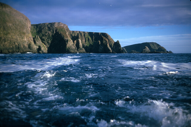
Horse Lie is a prominent coastal feature located in the Shetland Islands, situated off the northeast coast of Scotland. It is a distinctive headland or point that extends into the North Sea, marking the northernmost part of the Shetland mainland.

The area is characterized by steep cliffs that rise dramatically from the sea, reaching heights of approximately 150 meters (492 feet) at their highest point. These cliffs are composed of rugged rock formations, primarily consisting of sandstone and shale, which have been shaped over centuries by the relentless force of the ocean waves.

Horse Lie offers breathtaking views of the surrounding coastline, with its exposed position making it an ideal vantage point to observe the vast expanse of the North Sea. The area is home to a diverse range of marine wildlife, including seals, seabirds, and occasionally even whales and dolphins.

The headland is accessible by foot, with a footpath leading visitors along the cliff edge and offering stunning vistas at every turn. However, caution is advised as the cliffs can be dangerous, and visitors are advised to stay on the designated paths and avoid getting too close to the edge.

Horse Lie is a popular destination for nature enthusiasts, hikers, and photographers, who are captivated by its rugged beauty and wild ambiance. The area is also of geological significance, showcasing the natural processes that have shaped the Shetland Islands over millions of years.

If you have any feedback on the listing, please let us know in the comments section below.

Horse Lie Images

Images are sourced within 2km of 59.522627/-1.6579401 or Grid Reference HZ1970. Thanks to Geograph Open Source API. All images are credited.

South Harbour, Fair Isle
The Wick (Bay) of Hestigeo At the far south of Fair Isle, near the South Light.
The Wick (Bay) of Hestigeo
At the far south of Fair Isle, near the South Light.
Malcolm's Head At 107m, Malcolm's Head is the fifth highest hill on Fair Isle, after Ward Hill (217m), Burrashield Hill (150m), Sheep Rock (132m) and Vaasetter Hill (110m). Although one can argue about "What is a hill?", I do not think any other spot would really qualify, although there are many sea stacks.
Malcolm's Head
At 107m, Malcolm's Head is the fifth highest hill on Fair Isle, after Ward Hill (217m), Burrashield Hill (150m), Sheep Rock (132m) and Vaasetter Hill (110m). Although one can argue about "What is a hill?", I do not think any other spot would really qualify, although there are many sea stacks.
West coast of Fair Isle, looking back to Malcolm's Head The image position is uncertain.  Malcolm's Head is the headland  in the distance.  The west coast of Fair Isle sports some great cliff and geo scenery.
West coast of Fair Isle, looking back to Malcolm's Head
The image position is uncertain. Malcolm's Head is the headland in the distance. The west coast of Fair Isle sports some great cliff and geo scenery.
Winter Sea, Fair Isle
South Harbour Cro Stack in South Harbour; almost inevitably, Sheep Rock can be seen in the background.
South Harbour
Cro Stack in South Harbour; almost inevitably, Sheep Rock can be seen in the background.
Buildings at the end of the road, near the South Light You can also see the cemetery in the middle distance, centre of photo, which is also in this square.
Buildings at the end of the road, near the South Light
You can also see the cemetery in the middle distance, centre of photo, which is also in this square.
View across South Harbour, with Tirricks Fair Isle's Tirricks (Arctic Terns) had a disastrous breeding season in 2008 - food to rear chicks was so scarce they didn't even try, we were told by an RSPB officer.
View across South Harbour, with Tirricks
Fair Isle's Tirricks (Arctic Terns) had a disastrous breeding season in 2008 - food to rear chicks was so scarce they didn't even try, we were told by an RSPB officer.
Fair Isle coastline at Port Saider A very detailed map of Fair Isle on view at the Fair Isle Bird Observatory marks Port Saider slightly to the north of the position on the 1:25,000 OS Map.  This view south-west towards the Burrian is from the cliff edge at the OS location.
Fair Isle coastline at Port Saider
A very detailed map of Fair Isle on view at the Fair Isle Bird Observatory marks Port Saider slightly to the north of the position on the 1:25,000 OS Map. This view south-west towards the Burrian is from the cliff edge at the OS location.
Cliff edge of Meo Ness The lichens on the rocks at the cliff edge provide a great contrast to the green of Meo Ness.  The South Light is visible beyond South Harbour.
Cliff edge of Meo Ness
The lichens on the rocks at the cliff edge provide a great contrast to the green of Meo Ness. The South Light is visible beyond South Harbour.
The Burrian The Burrian is the offshore skerry viewed across one of the many geos on Fair Isle.
The Burrian
The Burrian is the offshore skerry viewed across one of the many geos on Fair Isle.
Heili Stack, Fair Isle One of several stacks and holms off the west coast of Malcolm's Head.
Heili Stack, Fair Isle
One of several stacks and holms off the west coast of Malcolm's Head.
Malcolm's Head Malcolm's Head summit with distant view towards Fair Isle Lighthouse.  Sheep graze the slopes of this TuMP keeping the grass short.  Ruined war buildings near summit.
Name: Malcolm's Head
Hill number: 103899
Height: 107m / 351ft
Area: 22: Shetland Islands
Class: 1
Grid ref: HZ195707 (est)
Drop: 82m
Col: 25m
Malcolm's Head
Malcolm's Head summit with distant view towards Fair Isle Lighthouse. Sheep graze the slopes of this TuMP keeping the grass short. Ruined war buildings near summit. Name: Malcolm's Head Hill number: 103899 Height: 107m / 351ft Area: 22: Shetland Islands Class: 1 Grid ref: HZ195707 (est) Drop: 82m Col: 25m
Looking Over The Edge At Kista Fair Isle has a rugged coastline with numerous sea stacks which make for many a dramatic view.
Looking Over The Edge At Kista
Fair Isle has a rugged coastline with numerous sea stacks which make for many a dramatic view.
Malcolm's Head, Fair Isle, from the sea Taken from the ferry en route from Lerwick to Kirkwall, several km to the NW.
Malcolm's Head, Fair Isle, from the sea
Taken from the ferry en route from Lerwick to Kirkwall, several km to the NW.
The low pastures at Malcolm's Head Beside the fresh painted South Light.
The low pastures at Malcolm's Head
Beside the fresh painted South Light.
The village and Sheep Rock from Malcolm's Head Tidy, well kept fields in the 'sheltered' centre of Fair Isle.
The village and Sheep Rock from Malcolm's Head
Tidy, well kept fields in the 'sheltered' centre of Fair Isle.
South Lighthouse, Fair Isle The last Scottish lighthouse to be automated in March 1998 see 
<span class="nowrap"><a title="http://www.nlb.org.uk/ourlights/history/fairislesouth.htm" rel="nofollow ugc noopener" href="http://www.nlb.org.uk/ourlights/history/fairislesouth.htm">Link</a><img style="margin-left:2px;" alt="External link" title="External link - shift click to open in new window" src="https://s1.geograph.org.uk/img/external.png" width="10" height="10"/></span>
South Lighthouse, Fair Isle
The last Scottish lighthouse to be automated in March 1998 see LinkExternal link
Show me another place!

Horse Lie is located at Grid Ref: HZ1970 (Lat: 59.522627, Lng: -1.6579401)

Unitary Authority: Shetland Islands

Police Authority: Highlands and Islands

What 3 Words

///looks.cookies.televise. Near Sumburgh, Shetland Islands

Related Wikis

Stroms Hellier

Stroms Hellier (Stroms Heelor) is a steep-sided rocky cove located off the Swartz Geo inlet on Fair Isle in the Scottish Shetland Islands. On 27 September...

El Gran Grifón

El Gran Grifón was the flagship of the Spanish Armada's supply squadron of Baltic hulks (built in and chartered from the City of Rostock, in modern-day...

Black Watch (full-rigged ship)

Black Watch was a large full-rigged ship built by Windsor shipbuilder Bennett Smith in Windsor, Nova Scotia. It was the last ship built by Smith in Windsor...

Fair Isle Airport

Fair Isle Airport (IATA: FIE, ICAO: EGEF), is a small airport located in Fair Isle, Shetland, Scotland. It is owned by the National Trust for Scotland...

Nearby Amenities

Located within 500m of 59.522627,-1.6579401
Malcolms Head
Place: locality
Lat/Long: 59.5203084/-1.6545205
The data included in this document is from www.openstreetmap.org. The data is made available under ODbL.

Have you been to Horse Lie?

Leave your review of Horse Lie below (or comments, questions and feedback).