Esma Taing

Coastal Feature, Headland, Point in Shetland

Scotland

Esma Taing

Papa Stour from Huxter, Sandness
Papa Stour from Huxter, Sandness Credit: Mike Pennington

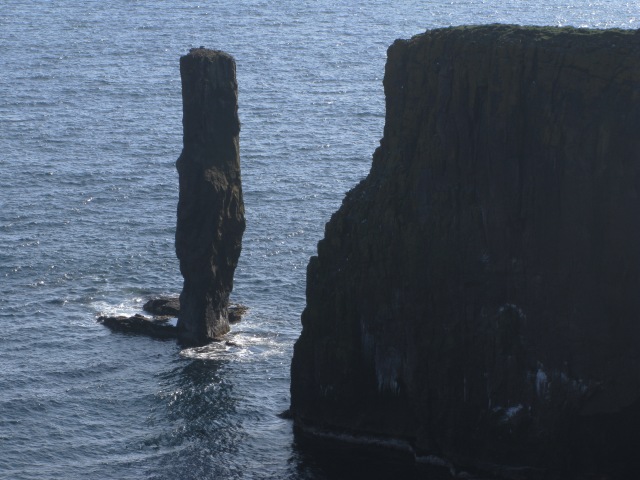
Esma Taing is a prominent coastal feature located in Shetland, a group of islands in the northernmost part of Scotland. It is specifically classified as a headland, which is a narrow strip of land that extends into the sea. This headland is characterized by its rugged and dramatic landscape, with steep cliffs and rock formations.

Esma Taing is notable for its unique geological features, shaped by millions of years of erosion from the powerful waves of the North Atlantic Ocean. The cliffs rise to impressive heights, providing breathtaking views of the surrounding coastline and the vast expanse of the sea. The rocks found in this area are primarily composed of sandstone and shale, displaying layers of sediment that have been compacted over time.

This coastal feature serves as an important habitat for various seabird species, including puffins, guillemots, and fulmars. The steep cliffs provide ideal nesting sites, and visitors to Esma Taing can often observe these birds in their natural environment.

In addition to its natural beauty, Esma Taing also holds historical significance. The area bears traces of ancient settlements, with archaeological sites dating back thousands of years. These remnants offer insights into the early human occupation of the Shetland Islands and provide a glimpse into the lives of its past inhabitants.

Esma Taing is a popular destination for nature enthusiasts, hikers, and photographers, who are drawn to its stunning coastal vistas and rich biodiversity. Visitors can explore the headland by following well-defined footpaths, ensuring a safe and enjoyable experience in this captivating part of Shetland's coastline.

If you have any feedback on the listing, please let us know in the comments section below.

Esma Taing Images

Images are sourced within 2km of 60.322427/-1.7138858 or Grid Reference HU1559. Thanks to Geograph Open Source API. All images are credited.

Papa Stour from Huxter, Sandness
Aesha Head One of the many fine stretches of coast on Papa Stours, Aesha Head is the furthest west point of the main island, though there are various smaller islands and skerries beyond.
Aesha Head
One of the many fine stretches of coast on Papa Stours, Aesha Head is the furthest west point of the main island, though there are various smaller islands and skerries beyond.
Natural Arch, Aesha Head This is a closer view of the fine arch in Aesha Head, with a glimpse of Lyra Skerry beyond.
Natural Arch, Aesha Head
This is a closer view of the fine arch in Aesha Head, with a glimpse of Lyra Skerry beyond.
Kirstan's Hole Actually, it isn't the Kirstan's Hole (or Christie's Hole) shown on the maps, but a second hole which opened suddenly a few years ago, where previously there had been a depression in the ground, into the same sea-cave system as the original Kirstan's Hole.
Kirstan's Hole
Actually, it isn't the Kirstan's Hole (or Christie's Hole) shown on the maps, but a second hole which opened suddenly a few years ago, where previously there had been a depression in the ground, into the same sea-cave system as the original Kirstan's Hole.
Plantiecrub near Flaes Point A plantiecrub is a small walled enclosure in which cabbage seedlings are grown until they are big enough to plant out in croft gardens. They are usually built well away from the croft to protect the seedlings against the crofters' hens.
Plantiecrub near Flaes Point
A plantiecrub is a small walled enclosure in which cabbage seedlings are grown until they are big enough to plant out in croft gardens. They are usually built well away from the croft to protect the seedlings against the crofters' hens.
Ruined Meal Mills Several traditional mills straddle this little burn. Inside the building was a fixed lower millstone, and a rotating upper millstone driven by the water falling on to the paddles below, which were mounted at 45º to the vertical drive shaft.
Ruined Meal Mills
Several traditional mills straddle this little burn. Inside the building was a fixed lower millstone, and a rotating upper millstone driven by the water falling on to the paddles below, which were mounted at 45º to the vertical drive shaft.
The Loch that Ebbs and Flows The interior of Papa Stour is mainly moorland, though there are several lochans in the central part. This one's curious name reflects its closeness to the sea, from which it is cut off only by an ayre or shingle spit.
The Loch that Ebbs and Flows
The interior of Papa Stour is mainly moorland, though there are several lochans in the central part. This one's curious name reflects its closeness to the sea, from which it is cut off only by an ayre or shingle spit.
Hurdibrack The last stretch of the footpath back from the west side of the island. In the middle distance is the wall which crosses the entire island, separating the arable land in the east from the pasture to the west.
Hurdibrack
The last stretch of the footpath back from the west side of the island. In the middle distance is the wall which crosses the entire island, separating the arable land in the east from the pasture to the west.
The Wall This is the wall which cuts across the whole island. The west side (left) has a steep face to prevent animals climbing over it. The east (right) side has a sloping face so that any animals which have managed to cross it can easily be driven back on to the pasture land.
The Wall
This is the wall which cuts across the whole island. The west side (left) has a steep face to prevent animals climbing over it. The east (right) side has a sloping face so that any animals which have managed to cross it can easily be driven back on to the pasture land.
Ruined House
Ruined House
Ruined house The number of ruined buildings on the island seem to far outnumber those still habitable or used.
Ruined house
The number of ruined buildings on the island seem to far outnumber those still habitable or used.
Road and ruins This is the main road for the island.  Even this close to the pier the ruins of abandoned crofts can be found just off the road.
Road and ruins
This is the main road for the island. Even this close to the pier the ruins of abandoned crofts can be found just off the road.
View towards Papa Stour Airstrip The cleared and smoothed ground in the upper right of the image is the airstrip for Papa Stour which is located in <a href="https://www.geograph.org.uk/gridref/HU1759">HU1759</a>.
View towards Papa Stour Airstrip
The cleared and smoothed ground in the upper right of the image is the airstrip for Papa Stour which is located in HU1759.
Unnamed Sea Stack Off Breigeo Head, Papa Stour (Big Isle of the Priests) At less than 20 metres high this little stack is not as impressive as it's compatriots such as a little down the coast <a href="https://www.geograph.org.uk/gridref/HU1461">HU1461</a>, but facing out onto the North Atlantic the situation is wild and imposing.

As with most sea stacks, this has probably formed and survived through being constituted from rock that is more solid and stable than that washed out from around them.  In many cases this results in providing ideal rock climbing routes in spectacular locations.  In this case, the rock visible in this image is of a good solid nature but as can be seen more clearly in <a href="https://www.geograph.org.uk/photo/798611">HU1560 : The problem with sea stacks...</a> it is overhanging and in addition lacks much in the way of cracks in which to place rock climbing protection.  Taken together these would make this an extremely difficult climb even if top roped.  The side of the stack facing away to the right of the image is also overhanging, albeit to a lesser extent, but the rock is somewhat green and slimy making it an unattractive ascent route.

Gaining access to the stack also presents some problems.  The water foaming around the stack prevents easy access by boat and even on a comparatively calm day such as that pictured here would make swimming to the stack a highly dangerous exercise.  The first visit to the top of the stack recorded by climbers is shown in the image <a href="https://www.geograph.org.uk/photo/798611">HU1560 : The problem with sea stacks...</a>.  For this, the only viable route to the stack was by Tyrolean traverse.
Unnamed Sea Stack Off Breigeo Head, Papa Stour (Big Isle of the Priests)
At less than 20 metres high this little stack is not as impressive as it's compatriots such as a little down the coast HU1461, but facing out onto the North Atlantic the situation is wild and imposing. As with most sea stacks, this has probably formed and survived through being constituted from rock that is more solid and stable than that washed out from around them. In many cases this results in providing ideal rock climbing routes in spectacular locations. In this case, the rock visible in this image is of a good solid nature but as can be seen more clearly in HU1560 : The problem with sea stacks... it is overhanging and in addition lacks much in the way of cracks in which to place rock climbing protection. Taken together these would make this an extremely difficult climb even if top roped. The side of the stack facing away to the right of the image is also overhanging, albeit to a lesser extent, but the rock is somewhat green and slimy making it an unattractive ascent route. Gaining access to the stack also presents some problems. The water foaming around the stack prevents easy access by boat and even on a comparatively calm day such as that pictured here would make swimming to the stack a highly dangerous exercise. The first visit to the top of the stack recorded by climbers is shown in the image HU1560 : The problem with sea stacks.... For this, the only viable route to the stack was by Tyrolean traverse.
The problem with sea stacks... The problem with sea stacks is how to get to them.

The sea conditions at the base of this one pretty much eliminate the possibilities of swimming.  One workable technique used here was to string a 100m abseil rope across the geo laying the rope on the top of the stack.  The rope can then be used for a tyrolean traverse to get over to the stack and back from it.
The problem with sea stacks...
The problem with sea stacks is how to get to them. The sea conditions at the base of this one pretty much eliminate the possibilities of swimming. One workable technique used here was to string a 100m abseil rope across the geo laying the rope on the top of the stack. The rope can then be used for a tyrolean traverse to get over to the stack and back from it.
Oystercatcher nest with eggs This nest was located in the pebbles at the high-point of the beach.  The eggs are camouflaged to be hard to see amongst the pebbles - although thankfully these were just noticeable enough to escape being trodden on.

The oystercatchers seem to be surviving relatively well on the island, whilst the previously abundant tern population has been largely destroyed by the skuas.
Oystercatcher nest with eggs
This nest was located in the pebbles at the high-point of the beach. The eggs are camouflaged to be hard to see amongst the pebbles - although thankfully these were just noticeable enough to escape being trodden on. The oystercatchers seem to be surviving relatively well on the island, whilst the previously abundant tern population has been largely destroyed by the skuas.
Lyra Stack Lyra Stack lies just to the south of Lyra Skerry which is the land in the right half of this image.
Lyra Stack
Lyra Stack lies just to the south of Lyra Skerry which is the land in the right half of this image.
Ruined meal mill The image shows the rear of one of the two mills at this location.  The image was taken from channel, now waterless, which fed water into the mill.
Ruined meal mill
The image shows the rear of one of the two mills at this location. The image was taken from channel, now waterless, which fed water into the mill.
Show me another place!

Esma Taing is located at Grid Ref: HU1559 (Lat: 60.322427, Lng: -1.7138858)

Unitary Authority: Shetland Islands

Police Authority: Highlands and Islands

What 3 Words

///ranted.decorated.coveted. Near Walls, Shetland Islands

Related Wikis

Papa Stour Airstrip

Papa Stour Airstrip is a small airstrip in the village of Biggings on the island of Papa Stour. Shetland, Scotland. == History == Papa Stour Airstrip opened...

Papa Stour

Papa Stour (Scots: Papa Stour) is one of the Shetland Islands in Scotland, with a population of under fifteen people, some of whom immigrated after an...

Biggings

Biggings is a village on the island of Papa Stour, in Shetland, Scotland. Papa Stour's church is situated at the south of Biggings. A homestead of Duke...

Forewick Holm

Forewick Holm is a 1-hectare (2.5-acre) island in the Sound of Papa in the Shetland islands, Scotland. Located between Papa Stour and the Sandness peninsula...

Have you been to Esma Taing?

Leave your review of Esma Taing below (or comments, questions and feedback).