Black Hole

Coastal Feature, Headland, Point in Aberdeenshire

Scotland

Black Hole

Forvie: the view along the beach to Rockend Almost at the northern limit of the wide sandy beach that runs some 12 miles from Aberdeen in the south to Rockend in the north. A windy day with rough seas that have carved intricate patterns into the sand.
Forvie: the view along the beach to Rockend Credit: Martyn Gorman

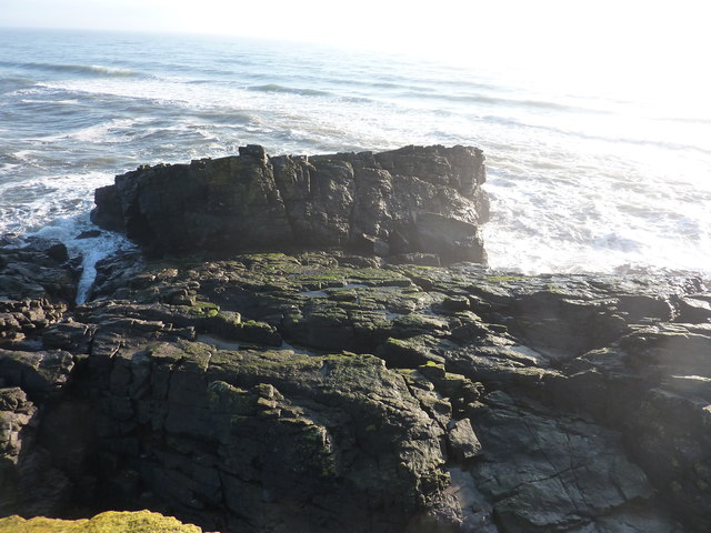
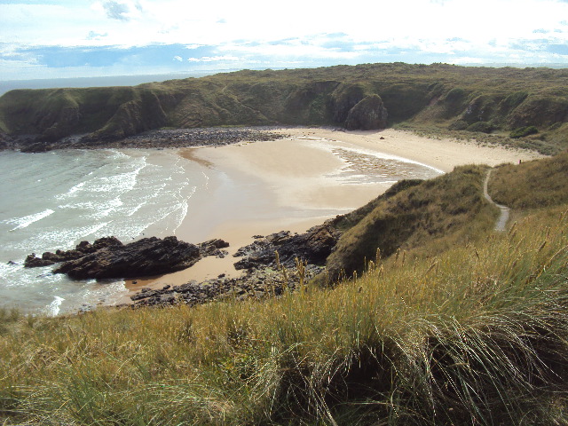
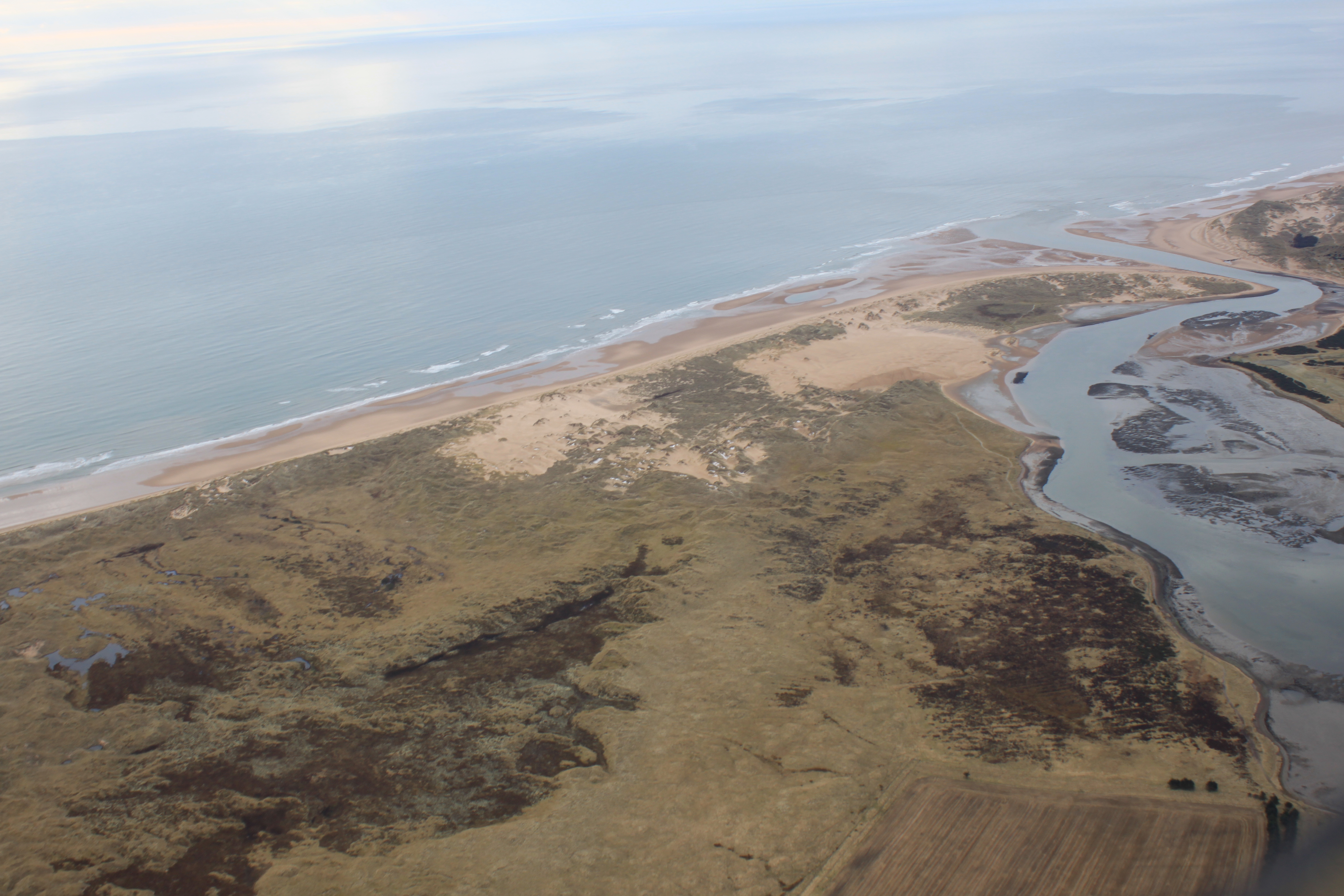
Black Hole is a prominent coastal feature located in Aberdeenshire, Scotland. It is a headland or point that juts out into the North Sea, offering spectacular views and natural beauty. The name "Black Hole" refers to a geological formation comprising towering cliffs and caves, which can be seen along the coastline.

The cliffs at Black Hole are made of rugged, sedimentary rock, providing a striking backdrop against the crashing waves of the North Sea. The area is known for its dramatic and picturesque scenery, attracting both local residents and tourists alike.

At low tide, visitors can explore the numerous caves that have formed over centuries of erosion. These caves are often adorned with colourful algae and moss, creating a unique and otherworldly atmosphere. The caves are also home to various marine species, including seals and seabirds, making Black Hole an ideal spot for wildlife enthusiasts.

In addition to its natural beauty, Black Hole also has historical significance. The area is believed to have been frequented by ancient inhabitants, as evidenced by the presence of prehistoric artifacts and remains found in the vicinity. Archaeological excavations have also revealed traces of early human settlements, further adding to the area's historical appeal.

Overall, Black Hole in Aberdeenshire is a captivating coastal feature that combines stunning natural scenery with a rich historical heritage. Its rugged cliffs, caves, and abundant wildlife make it a must-visit destination for nature lovers and history enthusiasts alike.

If you have any feedback on the listing, please let us know in the comments section below.

Black Hole Images

Images are sourced within 2km of 57.330524/-1.9558387 or Grid Reference NK0226. Thanks to Geograph Open Source API. All images are credited.

Forvie: the view along the beach to Rockend Almost at the northern limit of the wide sandy beach that runs some 12 miles from Aberdeen in the south to Rockend in the north. A windy day with rough seas that have carved intricate patterns into the sand.
Forvie: the view along the beach to Rockend
Almost at the northern limit of the wide sandy beach that runs some 12 miles from Aberdeen in the south to Rockend in the north. A windy day with rough seas that have carved intricate patterns into the sand.
Hackley Head at low tide A particularly low tide today, so this headland was worth a look to see if I could get into NK0326. No chance, I was 60m short, with a yawning gap below me ( rock-climbers only ), and I don't believe there is any rock showing 60m ahead.
Hackley Head at low tide
A particularly low tide today, so this headland was worth a look to see if I could get into NK0326. No chance, I was 60m short, with a yawning gap below me ( rock-climbers only ), and I don't believe there is any rock showing 60m ahead.
Rockend rocks from Hackley Head The sands in the distance stretch all the way to Aberdeen. Note the glorious weather - something about " a 100% probability of severe cold weather/icy conditions " down south.
Rockend rocks from Hackley Head
The sands in the distance stretch all the way to Aberdeen. Note the glorious weather - something about " a 100% probability of severe cold weather/icy conditions " down south.
Clouds Over Broad Haven Buchan coastline between Collieston and Forvie.
<span class="nowrap"><a title="http://en.wikipedia.org/wiki/Collieston" rel="nofollow ugc noopener" href="http://en.wikipedia.org/wiki/Collieston">Link</a><img style="margin-left:2px;" alt="External link" title="External link - shift click to open in new window" src="https://s1.geograph.org.uk/img/external.png" width="10" height="10"/></span>
Clouds Over Broad Haven
Buchan coastline between Collieston and Forvie. LinkExternal link
Fireplace in the Remains of Forvie Salmon Bothy Declining salmon stocks north of Aberdeen forced the abandonment of the salmon bothy on the edge of Forvie's Nature Reserve.  The bothy is now roofless, and will probably succumb to the same fate as Forvie Village; buried and forgotten beneath the ever shifting sands.

This shot taken from inside the bothy, showing the remains of a once substantial fireplace.
Fireplace in the Remains of Forvie Salmon Bothy
Declining salmon stocks north of Aberdeen forced the abandonment of the salmon bothy on the edge of Forvie's Nature Reserve. The bothy is now roofless, and will probably succumb to the same fate as Forvie Village; buried and forgotten beneath the ever shifting sands. This shot taken from inside the bothy, showing the remains of a once substantial fireplace.
Hackley Bay from North
Hackley Bay from top of path
Forvie Dunes Grass covered dunes on the south side of Forvie National Nature Reserve.
Forvie Dunes
Grass covered dunes on the south side of Forvie National Nature Reserve.
Looking seaward at Forvie Looking over the dunescape towards the North Sea at Forvie National Nature Reserve.
Looking seaward at Forvie
Looking over the dunescape towards the North Sea at Forvie National Nature Reserve.
Pillar at the end of the rainbow Sands of Forvie triangulation pillar with rainbow out to the north-west.
Pillar at the end of the rainbow
Sands of Forvie triangulation pillar with rainbow out to the north-west.
Looking south over Forvie Looking southwards over Forvie National Nature Reserve under a stormy sky.
Looking south over Forvie
Looking southwards over Forvie National Nature Reserve under a stormy sky.
Perthudden from Collieston Looking southwards over Perthudden from the clifftop path near Collieston.
Perthudden from Collieston
Looking southwards over Perthudden from the clifftop path near Collieston.
Beach at Forvie National Nature Reserve The turbines of the windfarm off the coast at Balmedie can be seen on the horizon.
Beach at Forvie National Nature Reserve
The turbines of the windfarm off the coast at Balmedie can be seen on the horizon.
Hackley Bay Spectacular bay on the coast off the Forvie National Nature Reserve. There are steep paths down to the beach at either side of the bay
Hackley Bay
Spectacular bay on the coast off the Forvie National Nature Reserve. There are steep paths down to the beach at either side of the bay
A sad relic of the railway age A thoroughly dilapidated railway carriage set amongst old dunes in the Forvie National Nature Reserve.
A sad relic of the railway age
A thoroughly dilapidated railway carriage set amongst old dunes in the Forvie National Nature Reserve.
Main path across Forvie National Nature Reserve Looking west. The old railway carriage at <a href="https://www.geograph.org.uk/photo/7251745">NK0026 : A sad relic of the railway age</a> can be seen at the foot of the slope.
Main path across Forvie National Nature Reserve
Looking west. The old railway carriage at NK0026 : A sad relic of the railway age can be seen at the foot of the slope.
Main path across Forvie National Nature Reserve Here passing through a patch of willow woodland.
Main path across Forvie National Nature Reserve
Here passing through a patch of willow woodland.
Track in Forvie National Nature Reserve Little used path which cuts directly across the Reserve on an inland route from Waterside to the Reserve Visitor Centre.
Track in Forvie National Nature Reserve
Little used path which cuts directly across the Reserve on an inland route from Waterside to the Reserve Visitor Centre.
Show me another place!

Black Hole is located at Grid Ref: NK0226 (Lat: 57.330524, Lng: -1.9558387)

Unitary Authority: Aberdeenshire

Police Authority: North East

What 3 Words

///listen.nodded.camera. Near Newburgh, Aberdeenshire

Related Wikis

Hackley Head

Hackley Head (otherwise Forvie Ness) is a headland in Aberdeenshire, northeast Scotland. Hackley Head is located to the south of Hackley Bay and to the...

Forvie

Forvie was a village in what is now the Forvie National Nature Reserve, located at the modern location of Rockend some fourteen miles north of Aberdeen...

Ythan Estuary

The Ythan Estuary (Scottish Gaelic: Inbhir Eithein) is the tidal component of the Ythan River, emptying into the North Sea 19 kilometres (12 mi) north...

Collieston

Collieston is a small former fishing village on the North Sea coast in Aberdeenshire, Scotland. The village lies just north of the Sands of Forvie Special...

Cotehill Loch

Cotehill Loch is a freshwater loch located in Scotland in the Aberdeenshire area, approximately one mile (1.5 km) northwest of the coastal town of Collieston...

Forvie National Nature Reserve

The Forvie National Nature Reserve is a national nature reserve owned and managed by NatureScot. It is located north of Newburgh in Aberdeenshire, in the...

Newburgh, Aberdeenshire

Newburgh is a coastal village in Aberdeenshire, Scotland. The village dates to 1261 AD, when Lord Sinclair wanted to establish a chapel in the area. Originally...

Newburgh On Ythan Golf Club

Newburgh On Ythan Golf Club was founded in 1888 by John Udny of Udny and a band of "founding fathers" and is one of the oldest golf courses in Scotland...

Nearby Amenities

Located within 500m of 57.330524,-1.9558387
Source: Old Landsat image trace
Lat/Long: 57.3345852/-1.9543023
Source: Old Landsat image trace
Lat/Long: 57.3342783/-1.9546778
Source: Old Landsat image trace
Lat/Long: 57.3344636/-1.9548066
Source: Old Landsat image trace
Lat/Long: 57.3343825/-1.9555147
Source: Old Landsat image trace
Lat/Long: 57.3341914/-1.9558902
Source: Old Landsat image trace
Lat/Long: 57.3338649/-1.9562425
Source: Old Landsat image trace
Lat/Long: 57.3334734/-1.9563837
Source: Old Landsat image trace
Lat/Long: 57.3329928/-1.9562232
Source: Old Landsat image trace
Lat/Long: 57.332651/-1.9556327
Source: Old Landsat image trace
Lat/Long: 57.3320314/-1.9529505
Source: Old Landsat image trace
Lat/Long: 57.3314349/-1.9534226
Source: Old Landsat image trace
Lat/Long: 57.3313886/-1.9535406
Source: Old Landsat image trace
Lat/Long: 57.3304214/-1.9561477
Source: Old Landsat image trace
Lat/Long: 57.3303346/-1.9562121
Source: Old Landsat image trace
Lat/Long: 57.3303867/-1.9566412
Source: Old Landsat image trace
Lat/Long: 57.3299002/-1.9560511
Source: Old Landsat image trace
Lat/Long: 57.3296454/-1.9591089
Source: Old Landsat image trace
Lat/Long: 57.3297612/-1.9593663
Source: Old Landsat image trace
Lat/Long: 57.3294716/-1.96104
Source: Old Landsat image trace
Lat/Long: 57.3291241/-1.9612761
Source: Old Landsat image trace
Lat/Long: 57.3289967/-1.9615765
Hackley Bay
Place: locality
Lat/Long: 57.3333298/-1.954414
Hackley Head
Place: locality
Wikidata: Q5637321
Wikipedia: en:Hackley Head
Lat/Long: 57.331761/-1.9518093
Black Hole
Place: locality
Lat/Long: 57.3301904/-1.9553733
The Smithy
Place: locality
Lat/Long: 57.3290845/-1.958356
The data included in this document is from www.openstreetmap.org. The data is made available under ODbL.

Have you been to Black Hole?

Leave your review of Black Hole below (or comments, questions and feedback).