Geodha Haisgeir
Coastal Feature, Headland, Point in Argyllshire
Scotland
Geodha Haisgeir

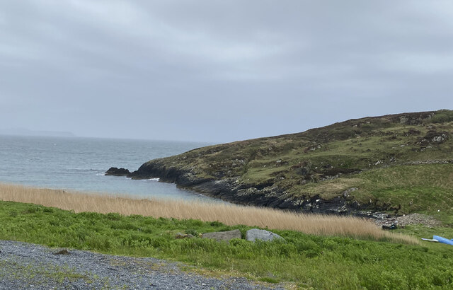
Geodha Haisgeir is a stunning coastal feature located in Argyllshire, Scotland. It is a headland or point that juts out into the Atlantic Ocean, offering breathtaking views of the surrounding area. This unique geological formation is characterized by its rugged cliffs, sandy beaches, and diverse wildlife.
The headland is known for its dramatic landscape, with towering cliffs that reach up to 100 meters in height. These cliffs are composed of layers of sedimentary rock, showcasing the area's geological history. The constant erosion from the crashing waves has created caves, arches, and stacks, adding to the allure of Geodha Haisgeir.
The sandy beaches surrounding the headland are a haven for nature lovers. They provide a perfect spot for picnics, sunbathing, and leisurely walks. The crystal-clear waters are ideal for swimming, and the area is popular among surfers due to its consistent waves.
Geodha Haisgeir is also home to a diverse range of wildlife. Seabirds, such as puffins, gannets, and fulmars, can be spotted nesting on the cliffs, while seals can often be seen basking on the rocks below. The surrounding waters are rich in marine life, attracting dolphins, porpoises, and even occasional sightings of whales.
For those seeking adventure, Geodha Haisgeir offers various outdoor activities. Hiking trails along the headland provide stunning panoramic views, while fishing enthusiasts can try their luck in the abundant waters. The area is also a popular spot for birdwatching, with many rare species being sighted.
Overall, Geodha Haisgeir is a captivating coastal feature that showcases the natural beauty and biodiversity of Argyllshire. Its rugged cliffs, sandy beaches, and diverse wildlife make it a must-visit destination for nature enthusiasts and outdoor adventurers alike.
If you have any feedback on the listing, please let us know in the comments section below.
Geodha Haisgeir Images
Images are sourced within 2km of 55.67384/-6.4992319 or Grid Reference NR1751. Thanks to Geograph Open Source API. All images are credited.


Geodha Haisgeir is located at Grid Ref: NR1751 (Lat: 55.67384, Lng: -6.4992319)
Unitary Authority: Argyll and Bute
Police Authority: Argyll and West Dunbartonshire
What 3 Words
///establish.computer.lizard. Near Portnahaven, Argyll & Bute
Related Wikis

Portnahaven
Portnahaven (Scottish Gaelic: Port na h-Abhainne, meaning river port) is a village on Islay in the Inner Hebrides, Scotland. The village is within the...

Orsay, Inner Hebrides
Orsay (Scottish Gaelic: Orasaigh) is a small island in the Inner Hebrides of Scotland. It lies a short distance off the west coast of the island of Islay...

Eilean Mhic Coinnich
Eilean Mhic Coinnich, also known as Mackenzie Island (although recorded on the Land Register as McKenseys Island), is an uninhabited island of 17.3 hectares...

Islay LIMPET
Islay LIMPET was the world's first commercial wave power device and was connected to the United Kingdom's National Grid. == History == Islay LIMPET (Land...
Nearby Amenities
Located within 500m of 55.67384,-6.4992319Have you been to Geodha Haisgeir?
Leave your review of Geodha Haisgeir below (or comments, questions and feedback).